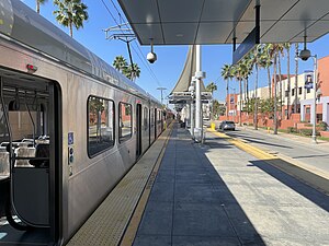
Aviation/LAX station is an elevated light rail station on the C Line of the Los Angeles Metro Rail system. It is located over Aviation Boulevard, after which the station is named, near its intersection with Imperial Highway and south of Century Freeway in Los Angeles, California. It opened as part of the Green Line on August 12, 1995. The station was initially named Aviation Blvd/I-105, but in 2003, it was simplified and renamed Aviation/LAX to highlight its proximity to Los Angeles International Airport.

Willowbrook/Rosa Parks station is a major transport hub and Los Angeles Metro Rail station that serves the A Line and C Line. The station, located at the intersection of Imperial Highway and Wilmington Avenue in the Willowbrook community of Los Angeles County, is a major transfer point for commuters.

Reseda station is a station on the G Line of the Los Angeles Metro Busway system. It is named after adjacent Reseda Boulevard, which travels north–south and crosses the east–west busway route. The station is in the Los Angeles neighborhood of Tarzana.

Balboa station is a station on the G Line of the Los Angeles Metro Busway system. It is named after adjacent Balboa Boulevard, which travels north–south and crosses the east–west transitway route. The station is in the Lake Balboa district of Los Angeles, in the central San Fernando Valley.

Sepulveda station is a station on the G Line of the Los Angeles Metro Busway system. It is named after nearby Sepulveda Boulevard, which travels north-south and crosses the east-west busway route. Unique among G Line stations, Sepulveda's platforms are not located at the cross street, but rather about a block west of it. The station is in the Van Nuys neighborhood of the City of Los Angeles, in the central San Fernando Valley.

Willow Street station is an at-grade light rail station on the A Line of the Los Angeles Metro Rail system. The station is located adjacent to Long Beach Boulevard its intersection with Willow Street, after which the station is named, in the Wrigley neighborhood of Long Beach, California.

Del Amo station is an elevated light rail station on the A Line of the Los Angeles Metro Rail system. The station is located between Compton Creek and Santa Fe Avenue, and elevated over the intersection of Del Amo Boulevard, after which the station is named, in the Los Angeles County community of Rancho Dominguez and near the city of Carson.

Lakewood Boulevard station is a below-grade light rail station on the C Line of the Los Angeles Metro Rail system. It is situated in the median of Interstate 105, below Lakewood Boulevard, after which the station is named. The station serves the city of Downey, California and opened as part of the Green Line on August 12, 1995.

Hawthorne/Lennox station is a below-grade light rail station on the C Line of the Los Angeles Metro Rail system. It is situated in the median of Interstate 105 and named after Hawthorne Boulevard and the Lennox community where it is located. The station is also close to the city of Hawthorne and opened as part of the Green Line on August 12, 1995.

El Segundo station is an elevated light rail station on the C Line of the Los Angeles Metro Rail system. It is located over El Segundo Boulevard, after which the station is named, near its intersection with Nash Street in El Segundo, California. It opened with the commencement of Green Line service on August 12, 1995.

Canoga station is a station on the G Line of the Los Angeles Metro Busway system located on Canoga Avenue in Canoga Park, in the western San Fernando Valley. It is part of the Los Angeles Metro Busway system.

Mariachi Plaza station is an underground light rail station on the E Line of the Los Angeles Metro Rail system. It is located under 1st Street at the intersection of Boyle Avenue, with the main exit located at Mariachi Plaza, after which the station is named. The plaza is the historic gateway to the Boyle Heights neighborhood of Los Angeles. This station opened in 2009 as part of the Gold Line Eastside Extension and was one of two underground stations on the Eastside Extension.

Little Tokyo/Arts District station is an underground light rail station on the Los Angeles Metro Rail system. It replaced an at-grade station with the same name that was located on the east side of Alameda Street between 1st Street and Temple Street, on the edge of Little Tokyo and the Arts District in Downtown Los Angeles. The at-grade station opened in 2009 as part of the Gold Line Eastside Extension and was served by the L Line. The at-grade station closed in October 2020, and the new underground station on the south side of 1st Street between Central Avenue and Alameda Street opened on June 16, 2023.

East LA Civic Center station is an at-grade light rail station on the E Line of the Los Angeles Metro Rail system. It is located at the intersection of 3rd Street and Mednik Avenue in East Los Angeles, California, adjacent to the Los Angeles County government buildings of the East Los Angeles Civic Center, after which the station is named. This station opened on November 15, 2009, as part of the Gold Line Eastside Extension.

Maravilla station is an at-grade light rail station on the E Line of the Los Angeles Metro Rail system. It is located at the intersection of 3rd Street and Ford Boulevard in East Los Angeles, California near Interstate 710. This station opened in 2009 as part of the Gold Line Eastside Extension.

Indiana station is an at-grade light rail station on the E Line of the Los Angeles Metro Rail system. It is located alongside South Indiana Street as the line transitions between 1st Street and 3rd Street on the eastern edge of the Boyle Heights neighborhood of Los Angeles. This station opened in 2009 as part of the Gold Line Eastside Extension.

Soto station is an underground light rail station on the E Line of the Los Angeles Metro Rail system. It is located underneath 1st Street at its intersection with Soto Street in the heart of the Boyle Heights neighborhood of Los Angeles. This station opened in 2009 as part of the Gold Line Eastside Extension and was one of two underground stations on the Eastside Extension.

Pico/Aliso station is an at-grade light rail station on the E Line of the Los Angeles Metro Rail system. It is located in the median of East 1st Street between South Anderson Street and South Utah Street in the Boyle Heights neighborhood of Los Angeles. This station opened on November 15, 2009, as part of the Gold Line Eastside Extension.
APU/Citrus College station is an at-grade light rail station on the A Line of the Los Angeles Metro Rail system. It is located between Palm Drive and Citrus Avenue, a block north of Foothill Boulevard, in Azusa, California. It is named after the nearby Azusa Pacific University (APU) and Citrus College.

Roscoe station is a station on the G Line of the Los Angeles Metro Busway system located in Canoga Park in the western San Fernando Valley, it opened in June 2012. It is part of the Los Angeles Metro Busway system. The station is currently in service as part of the Metro Orange Line Chatsworth Extension. The station has bicycle lockers. A parking lot was not planned for this station.