Bank Foot Metro station

Last updated

Bank Foot
Tyne and Wear Metro station
Bank Foot, Tyne and Wear Metro - geograph.org.uk - 610894.jpg
General information
Location Kenton Bank Foot, Newcastle upon Tyne
England
Coordinates 55°00′50″N1°40′41″W / 55.0139176°N 1.6780732°W / 55.0139176; -1.6780732 Coordinates: 55°00′50″N1°40′41″W / 55.0139176°N 1.6780732°W / 55.0139176; -1.6780732
Grid reference NZ206688
Transit authority Tyne and Wear PTE
Platforms2
Tracks2
Construction
Parking62 spaces
Bicycle facilities8 cycle pods
Disabled accessStep-free access to platform
Other information
Station codeBFT
Fare zoneB
History
Original company Tyne and Wear Metro
Key dates
10 May 1981Opened [lower-alpha 1]
Passengers
2017/180.11 million [1]
Services
Preceding station Tyne Wear Metro logo.svg Tyne and Wear Metro Following station
Kingston Park
towards South Hylton
Green Line Callerton Parkway
towards Airport
Location
Newcastle upon Tyne UK ward map 2010 (blank).svg
Red pog.svg
Bank Foot
Tyne and Wear UK location map.svg
Red pog.svg
Bank Foot
Location in Tyne and Wear, England

Bank Foot is a Tyne and Wear Metro station, serving the suburb of Kenton Bank Foot, Newcastle upon Tyne in Tyne and Wear, England. It joined the network as a terminus station on 10 May 1981, following the opening of the second phase of the network, between South Gosforth and Bank Foot. The station was used by 0.11 million passengers in 2017–18, making it the third-least-used station on the network, after St Peter's and Pallion.

Contents

History

The station is located at the site of the former Kenton Bank station, which opened on 1 June 1905 as part of the Gosforth and Ponteland Light Railway. The line closed to passengers on 17 June 1929, with goods services operating from the station until January 1966. [2] [3]

Following the opening of the Tyne and Wear Metro station as a terminus in May 1981, the approach to Bank Foot was single track, with one platform on the south side (now used by trains towards Airport). For the first few years of operation, the Tyne and Wear Metro shared the line with freight services running to ICI Callerton, where explosives were transferred from rail to road for onward transport to quarries in Northumberland. This traffic ceased following the closure of ICI Callerton, in March 1989.

There were originally three tracks here. On the south side was the platform line, on the north side a siding for use by the Tyne and Wear Metro, and in the middle the non-electrified through line for freight services. The ownership boundary between the Tyne and Wear Metro and British Rail was the level crossing on Station Road, to the west of the station.

When the line was extended to Airport, the bridge to the east was re-built as double track, with Bank Foot station re-modelled as a double track station. A second platform was built on the north side (now used for trains towards South Hylton). The level crossing was also re-built in the same style as the other open level crossings on the system.

Following the opening of the 3.5 km (2.2 mi) line between Bank Foot and Airport on 17 November 1991, the station opened to through services. [4] During the construction of the line, a dedicated bus service operated between Bank Foot and Newcastle International Airport. [5]

In October 2012, traffic enforcement cameras were installed at the level crossings at Bank Foot and Kingston Park. [6] Similar cameras were installed at Callerton Parkway in 2008. [7]

In 2018, the station, along with others on the Airport branch, were refurbished as part of the Metro: All Change programme. The project saw improvements to accessibility, security and energy efficiency, as well as the re-branding of the station to the new black and white corporate colour scheme. [8]

Facilities

Step-free access is available at all stations across the Tyne and Wear Metro network, with ramped access to both platforms at Bank Foot. The station is equipped with ticket machines, waiting shelter, seating, next train information displays, timetable posters, and an emergency help point on both platforms. Ticket machines are able to accept payment with credit and debit card (including contactless payment), notes and coins. [9] [10] The station is also fitted with smartcard validators, which feature at all stations across the network. [11] [12]

A pay and display car park is available, with 62 spaces. There is also the provision for cycle parking, with eight cycle pods available for use. [13]

Services

As of April 2021, the station is served by up to five trains per hour on weekdays and Saturday, and up to four trains per hour during the evening and on Sunday. [14]

Rolling stock used: Class 599 Metrocar

Notes

  1. Through services to Newcastle Airport commenced on 17 November 1991.

Related Research Articles

<span class="mw-page-title-main">Tyne and Wear Metro</span> Rapid-transit rail network in north-east England

The Tyne and Wear Metro is an overground and underground light rail rapid transit system serving Newcastle upon Tyne, Gateshead, North Tyneside, South Tyneside, and the City of Sunderland. The network opened in stages from August 1980 and now serves a total of 60 stations, with two lines covering 77.5 km (48.2 mi) of track. The Metro can be accessed from a mixture of under ground and above ground stations. It has been described as the "first modern light rail system in the United Kingdom". The system is currently owned and operated by the Tyne and Wear Passenger Transport Executive, thus is fully under public ownership and operation.

<span class="mw-page-title-main">South Gosforth Metro station</span> Tyne and Wear Metro station in Newcastle upon Tyne

South Gosforth is a Tyne and Wear Metro station, serving the suburb of Gosforth, Newcastle upon Tyne in Tyne and Wear, England. It joined the network on 11 August 1980, following the opening of the first phase of the network, between Haymarket and Tynemouth via Four Lane Ends.

<span class="mw-page-title-main">Heworth Interchange</span> Tyne and Wear Metro and railway station in Gateshead

Heworth Interchange consists of a National Rail, Tyne and Wear Metro and bus station. It is located in the suburb of Heworth, Gateshead in Tyne and Wear, England, and opened on 5 November 1979 for rail and bus services. The station joined the Tyne and Wear Metro network around two years later, on 15 November 1981.

<span class="mw-page-title-main">Ilford Road Metro station</span> Tyne and Wear Metro station in Newcastle upon Tyne

Ilford Road is a Tyne and Wear Metro station, primarily serving the suburb of Gosforth, Newcastle upon Tyne, England. It joined the network on 11 August 1980, following the opening of the first phase of the network, between Haymarket and Tynemouth via Four Lane Ends.

<span class="mw-page-title-main">Fawdon Metro station</span> Tyne and Wear Metro station in Newcastle upon Tyne

Fawdon is a Tyne and Wear Metro station, serving the Fawdon and Kenton districts of Newcastle upon Tyne. It joined the network on 10 May 1981, following the opening of the second phase of the network, between South Gosforth and Bank Foot, and is situated on the Green Line.

<span class="mw-page-title-main">Percy Main Metro station</span> Tyne and Wear Metro station in North Tyneside

Percy Main is a Tyne and Wear Metro station, serving the suburb of Percy Main, North Tyneside in Tyne and Wear, England. It joined the network on 14 November 1982, following the opening of the fourth phase of the network, between Tynemouth and St James via Wallsend.

<span class="mw-page-title-main">Wansbeck Road Metro station</span> Tyne and Wear Metro station in Newcastle upon Tyne

Wansbeck Road is a Tyne and Wear Metro station, serving the suburbs of Coxlodge and Gosforth, Newcastle upon Tyne in Tyne and Wear, England. It joined the network on 10 May 1981, following the opening of the second phase of the network, between South Gosforth and Bank Foot.

<span class="mw-page-title-main">Callerton Parkway Metro station</span> Tyne and Wear Metro station in Newcastle upon Tyne

Callerton Parkway is a Tyne and Wear Metro station, serving the hamlet of Black Callerton and suburb of Woolsington, Newcastle upon Tyne in Tyne and Wear, England. It joined the network on 17 November 1991, following the opening of the extension from Bank Foot to Newcastle Airport.

<span class="mw-page-title-main">West Monkseaton Metro station</span> Tyne and Wear Metro station in North Tyneside

West Monkseaton is a Tyne and Wear Metro station, serving the village of Earsdon and suburb of Monkseaton, North Tyneside in Tyne and Wear, England. It joined the network on 11 August 1980, following the opening of the first phase of the network, between Haymarket and Tynemouth via Four Lane Ends.

<span class="mw-page-title-main">Newcastle Airport Metro station</span> Tyne and Wear Metro station in Newcastle upon Tyne

Airport is a Tyne and Wear Metro station, serving Newcastle International Airport, Newcastle upon Tyne in Tyne and Wear, England. It joined the network as a terminus station on 17 November 1991, following the opening of the extension from Bank Foot to Airport.

<span class="mw-page-title-main">Seaburn Metro station</span> Tyne and Wear Metro station in Sunderland

Seaburn is a Tyne and Wear Metro station, serving the suburbs of Fulwell and Seaburn, City of Sunderland in Tyne and Wear, England. It joined the network on 31 March 2002, following the opening of the extension from Pelaw to South Hylton.

<span class="mw-page-title-main">Kingston Park Metro station</span> Tyne and Wear Metro station in Newcastle upon Tyne

Kingston Park is a Tyne and Wear Metro station, serving the suburb of Kingston Park, Newcastle upon Tyne in Tyne and Wear, England. It joined the network on 15 September 1985.

<span class="mw-page-title-main">Regent Centre Interchange</span> Tyne and Wear Metro station in Newcastle upon Tyne

Regent Centre is a Tyne and Wear Metro station in Zone B, serving the suburb of Gosforth, Newcastle upon Tyne. It joined the network on 10 May 1981, following the opening of the second phase of the network, between South Gosforth and Bank Foot.

<span class="mw-page-title-main">Manors Metro station</span> Tyne and Wear Metro station in Newcastle upon Tyne

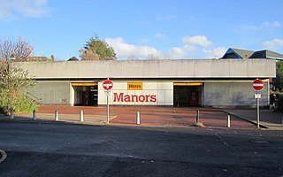
Manors is a Tyne and Wear Metro station, serving the Shieldfield area in Newcastle upon Tyne. It joined the network on 14 November 1982, following the opening of the fourth phase of the network, between Tynemouth and St James via Wallsend. The station is located near to Manors National Rail station, which is on the East Coast Main Line. However, the stations are not directly connected.

<span class="mw-page-title-main">Pallion Metro station</span> Tyne and Wear Metro station in Sunderland

Pallion is a Tyne and Wear Metro station, serving the suburb of Pallion, City of Sunderland in Tyne and Wear, England. It joined the network on 31 March 2002, following the opening of the Wearside extension – a project costing in the region of £100 million. The station was used by 92,060 passengers in 2017–18, making it the least-used station on the network.

<span class="mw-page-title-main">Transport in Tyne and Wear</span> Overview of transport in Tyne and Wear

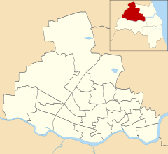
Tyne and Wear is a metropolitan area covering the cities of Newcastle upon Tyne and Sunderland, as well as North and South Tyneside, Gateshead and Washington.

<span class="mw-page-title-main">Ponteland Railway</span> Partially operational railway line in Northumberland and Tyne and Wear

The Ponteland Railway was a 7-mile (11 km) single-track branch line, which linked Gosforth in Tyne and Wear with Ponteland in Northumberland. A 1+14-mile (2 km) sub-branch line also ran between Ponteland and Darras Hall.

<span class="mw-page-title-main">Kenton Bank railway station</span> Disused railway station in Tyne and Wear on the Ponteland Railway

Kenton Bank was a railway station on the Ponteland Railway, which ran between South Gosforth and Ponteland, with a sub-branch line to Darras Hall. The station served Kenton in Newcastle upon Tyne.

Callerton was a railway station on the Ponteland Railway, which ran between South Gosforth and Ponteland, with a sub-branch line to Darras Hall. The station served Woolsington in Newcastle upon Tyne.

Coxlodge was a railway station on the Ponteland Railway, which ran between South Gosforth and Ponteland, with a sub-branch line to Darras Hall. The station served Coxlodge and Fawdon in Newcastle upon Tyne.

References

  1. "Tyne & Wear Metro usage figures". 2017–2018. Retrieved 21 August 2019.
  2. "Disused Stations: Kenton Bank Station". Disused Stations. Retrieved 24 May 2020.
  3. "Ponteland Light Railway & Darras Hall Branch". Northumbrian Railways. Archived from the original on 3 April 2008. Retrieved 3 April 2008.{{cite web}}: CS1 maint: unfit URL (link)
  4. "Metro's airport extension celebrates its 25th year". Nexus. 17 November 2016. Retrieved 24 May 2020.
  5. "OK for airport". Commercial Motor . 3 May 1990. p. 25. Retrieved 24 May 2020.{{cite web}}: CS1 maint: url-status (link)
  6. "Safety cameras for Metro level crossings". Nexus. 16 October 2012. Retrieved 24 May 2020.
  7. "Cameras for Metro train crossing". BBC News. 19 April 2008. Retrieved 23 March 2014.
  8. Peskett, Joe (3 October 2017). "£300k scheme to improve access at five Newcastle metro stations". Access and Mobility Professional. Retrieved 24 May 2020.
  9. "Metro passengers feel the benefit of contactless payment". Nexus. 13 January 2014. Retrieved 24 May 2020.
  10. "Revamp for Metro ticket machines". BBC News. 11 December 2011. Retrieved 24 May 2020.
  11. "City Metro stations get new smart ticket machines and gates". Nexus. 22 October 2012. Retrieved 24 May 2020.
  12. "Pop card validators at Metro stations are put through their paces". Nexus. 21 March 2013. Retrieved 24 May 2020.
  13. "Timetables and stations: Bank Foot". Nexus. Retrieved 24 May 2020.
  14. "Timetables and stations: Bank Foot". Tyne and Wear Passenger Transport Executive . Archived from the original on 19 November 2020. Retrieved 30 March 2021.