Barkley Regional Airport

Last updated
Barkley Regional Airport
Barkley Regional Airport Logo 2023.png
New Barkley Regional Terminal.jpg
New Terminal at Barkley Regional Airport, 2023
Summary
Airport typePublic
OwnerBarkley Regional Airport Authority
Serves Jackson Purchase Region
Elevation  AMSL 410 ft / 125 m
Coordinates 37°03′37″N088°46′23″W / 37.06028°N 88.77306°W / 37.06028; -88.77306
Website FlyBarkley.com
Map
USA Kentucky relief location map.svg
Airplane silhouette.svg
PAH
Usa edcp relief location map.png
Airplane silhouette.svg
PAH
Runways
Direction LengthSurface
ftm
5/236,5001,981Asphalt
14/325,4991,676Asphalt
Statistics
Aircraft operations (2018)23,537
Based aircraft (2018)40
Total passengers served (2016)40,770

Barkley Regional Airport( IATA : PAH [2] , ICAO : KPAH, FAA LID : PAH) is an American domestic airport in West Paducah, Kentucky, 14 miles west of Paducah in McCracken County. [1] It is used for general aviation and sees one airline, subsidized by the Essential Air Service program.

Contents

The only airline is Contour Airlines, with Embraer 145 flights to Charlotte Douglas International Airport in Charlotte, North Carolina. A new $43M terminal building opened in June 2023, roughly 70 years after the original terminal was built in 1953. [3]

The Federal Aviation Administration (FAA) National Plan of Integrated Airport Systems for 2023-2027 categorized it as a non-hub primary commercial service facility. [4]

Federal Aviation Administration records say Barkley Regional had 13,643 passenger boardings (enplanements) in calendar year 2021 and 14,677 in 2022. [5]

History

Barkley Regional Airport is named after former Vice President of the United States Alben W. Barkley, who was from western Kentucky. The airport was previously served by Northwest Airlink (operated by Mesaba Airlines) Saab 340 regional turboprops with service to Memphis International Airport. When Northwest Airlines merged with Delta Air Lines, service to Memphis from Paducah was discontinued. New airline service began when Chicago-based United Airlines started daily Canadair CRJ200 regional jets nonstop to Chicago O'Hare International Airport with this service operated by SkyWest Airlines flying as United Express on behalf of United. Service began in the winter of 2010. This service was replaced by Contour Airlines on December 6, 2022, with nonstop flights to Charlotte, NC, using Embraer 145 regional jets.

Originally built as a military airfield in 1941, thanks to the efforts of then Senator Alben Barkley, the airfield was originally used to facilitate U.S. Army Air Corps B-17 bomber crew training which was taking place at nearby Dyersburg, TN. In 1945 the U.S. government deeded the land to the city of Paducah and McCracken County, making it available for civilian use.

On April 1, 1946, a Chicago and Southern Air Lines (C&S Air Lines) Douglas DC-3 was the first airline flight out of Paducah and the airport has had scheduled airline flights ever since. Chicago and Southern was then acquired by Delta Air Lines which in turn continued to serve Paducah. [6] Ozark Airlines arrived in 1951. According to the Official Airline Guide (OAG), two airlines were serving Paducah in 1976: Delta with McDonnell Douglas DC-9-30 jets nonstop from Evansville and Memphis as well as direct, no change of plane DC-9-30 jet flights from Atlanta, Birmingham, AL, Boston, Chicago O'Hare Airport, Indianapolis and Philadelphia, and Ozark with nonstop McDonnell Douglas DC-9-30 jet and/or Fairchild FH-227B turboprop flights from Clarksville, TN, Louisville, Nashville and St. Louis as well as direct, no change of plane DC-9-30 jet flights from Chicago O'Hare Airport, Columbia, MO, Indianapolis, Kansas City and Milwaukee. [7] Delta left in 1979 and Ozark pulled out in 1980.

Several commuter and regional air carriers operating turboprop aircraft served Paducah during the 1980s. In 1981 Air Illinois was operating nonstop service from Cape Girardeau, MO, Carbondale, IL, Memphis and St. Louis with larger Hawker Siddeley HS 748 regional aircraft as well as with smaller de Havilland Canada DHC-6 Twin Otter and Handley Page Jetstream commuter aircraft while Allegheny Commuter was flying on behalf of USAir nonstop from Louisville with Beechcraft commuter aircraft. [8] In 1985 Allegheny Commuter had expanded its service on behalf of USAir with nonstops from Evansville, Louisville, Nashville, and Owensboro, KY with Beechcraft 99s while Britt Airways was flying nonstop from Cape Girardeau, Evansville, Memphis and St. Louis with Fairchild Swearingen Metroliner propjets. [9] By 1989 three airlines were serving the airport: American Eagle operating on behalf of American Airlines with nonstop service from Nashville flown with Fairchild Swearingen Metroliners, Northwest Airlink flying on behalf of Northwest Airlines nonstop from Evansville and Memphis with British Aerospace BAe Jetstream 31 and Saab 340 aircraft, and Trans World Express operated by Air Midwest on behalf of Trans World Airlines (TWA) nonstop from Evansville and St. Louis flown with Fairchild Swearingen Metroliners and Saab 340 aircraft. [10]

Facilities

Barkley Regional Airport covers 1,018 acres (412 ha) at an elevation of 410 feet (125 m). It has two asphalt runways: 5/23 is 6,500 by 150 feet (1,981 x 46 m) and 14/32 is 5,499 by 150 feet (1,676 x 46 m). [1] An expansion of runway 14/32 was completed in December 2005.

In 2015 the airport had 23,269 aircraft operations, average 63 per day: 80% general aviation, 8% military, 6% air taxi and 6% airline. In March 2017, 40 aircraft were based at the airport: 29 single-engine, 6 multi-engine, 4 jet and 1 helicopter. [1]

FBO, Fixed Base Operator Midwest Aviation provides Charter services, flight training, aircraft maintenance, aircraft rental, avionics service, aircraft sales, and other aviation services. website https://www.midwest-aviation.com/

FAA data visit: FAA data

Airline and destination

Passenger

AirlinesDestinationsRefs.
Contour Airlines Charlotte [11]

Statistics

Carrier shares (January 2023 – December 2023) [12]
Carrier  Passengers (arriving and departing)
Contour
24,810(100%)
Top domestic destinations (January 2023 – December 2023) [12]
RankAirportPassengersAirline
1 Charlotte 12,480Contour

Accidents and incidents

See also

Related Research Articles

<span class="mw-page-title-main">Waterloo Regional Airport</span> Airport

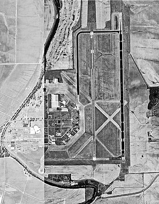
Waterloo Regional Airport ( Livingston Betsworth Field) is four miles (6 km) northwest of Waterloo, in Black Hawk County, Iowa. It is used for general aviation and sees one airline.

Golden Triangle Regional Airport is a public use airport in Lowndes County, Mississippi. The airport is located approximately midway between the cities of Starkville, Columbus, and West Point, Mississippi, and serves the surrounding Golden Triangle region of Mississippi and parts of West Alabama. GTR is used for general and military aviation, and charter aircraft.

<span class="mw-page-title-main">Evansville Regional Airport</span> Public airport in Indiana, US

Evansville Regional Airport is three miles north of Evansville, in Vanderburgh County, Indiana, United States. It is owned and operated by the Evansville-Vanderburgh Airport Authority District.

<span class="mw-page-title-main">Eastern Oregon Regional Airport</span> Airport

Eastern Oregon Regional Airport is a public airport three miles northwest of Pendleton, in Umatilla County, Oregon, United States. Commercial service is provided by Boutique Air to Portland, subsidized by the Essential Air Service program.

Hays Regional Airport is three miles southeast of Hays, in Ellis County, Kansas, United States. It is used for general aviation and sees one airline, United Express.

<span class="mw-page-title-main">Columbia Regional Airport</span> Airport in Missouri, United States of America

Columbia Regional Airport is a commercial passenger airport serving Columbia, Missouri. Located about 12 miles (19 km) southeast of Columbia in Boone County, Missouri, it is the only commercial airport in Mid-Missouri and also serves the state capital of Jefferson City. As of 2022, commercial passenger service is provided by American Airlines subsidiary American Eagle. The airport opened in 1968, replacing the Columbia Municipal Airport off of Interstate 70. It is frequently used for charter flights by college athletic teams visiting the University of Missouri and for MU team flights.

<span class="mw-page-title-main">Falls International Airport</span> Airport

Falls International Airport is a city-owned public-use airport located in International Falls, a city in Koochiching County, Minnesota, United States. It is mostly used for general aviation but is also served by one commercial airline with scheduled passenger service subsidized by the Essential Air Service program.

<span class="mw-page-title-main">Fort Smith Regional Airport</span> Public airport in Fort Smith, Arkansas, US

Fort Smith Regional Airport is a public use airport located near the Interstate 540 freeway three nautical miles (6 km) southeast of the central business district of Fort Smith, in Sebastian County, Arkansas, United States. FSM is governed by the Fort Smith Airport Commission as established by the City of Fort Smith, Arkansas. It serves the transportation needs of residents and businesses of western Arkansas and eastern Oklahoma. FSM is currently served by American Eagle, the regional airline affiliate of American Airlines. It has a large population of corporate and general aviation aircraft. A full-service fixed-base operator (FBO), Signature Flight Support, provides service to general aviation, airline, and military operators.

Memorial Field Airport is located in City of Hot Springs, in Garland County, Arkansas, United States, 3 miles (4.8 km) southwest of Downtown Hot Springs. It serves nearby Hot Springs National Park. The airport is used for general aviation; airline flights are subsidized by the federal government's Essential Air Service program at a cost of $1,637,012.

<span class="mw-page-title-main">Greenville Mid-Delta Airport</span> Airport

Greenville Mid-Delta Airport, operating as Mid Delta Regional Airport until 2011, is a public use airport in unincorporated Washington County, Mississippi, United States. It is located five nautical miles northeast of the central business district of Greenville, the city that owns the airport. It is served by one commercial airline, Contour Airlines, which is subsidized by the Essential Air Service program. Formerly, the facility was known as Greenville Air Force Base.

<span class="mw-page-title-main">Houghton County Memorial Airport</span> Airport in Calumet Michigan, United States

Houghton County Memorial Airport is a county-owned public-use airport located four nautical miles southwest of the central business district of Calumet, a village in Houghton County, Michigan, United States. The airport is situated in the unincorporated community of Oneco in Franklin Township, near the village of Calumet on the Keweenaw Peninsula in northwest of the Upper Peninsula of Michigan. A limited scheduled commercial service is available, subsidized by the Essential Air Service program. In addition, Royale Air Service provides a seaplane service to Isle Royale National Park depending on traveler demand.

<span class="mw-page-title-main">Chippewa Valley Regional Airport</span> Airport located in Chippewa County, Wisconsin

Chippewa Valley Regional Airport is a public use airport in Chippewa County, Wisconsin, United States. The airport is owned by Eau Claire county and is located 3 nautical miles north of the central business district of the city of Eau Claire, Wisconsin.

<span class="mw-page-title-main">Owensboro–Daviess County Regional Airport</span> Small airport in Kentucky

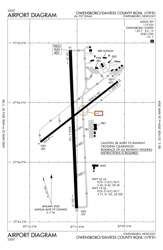
Owensboro–Daviess County Airport is a public use airport located three miles southwest of Owensboro, in Daviess County, Kentucky. The airport is owned by both the city and county. One airline schedules passenger flights, subsidized by the Essential Air Service program.

<span class="mw-page-title-main">Tupelo Regional Airport</span> Airport

Tupelo Regional Airport is a public use airport located 3.7 miles; 3.2 nautical miles (6 km) west of the central business district of Tupelo, a city in Lee County, Mississippi, United States. It is owned by the Tupelo Airport Authority. The airport is mostly used for general aviation, but is also served by one commercial airline with scheduled passenger service subsidized by the federal Essential Air Service (EAS) program. Many college football teams visiting the University of Mississippi, 49 miles west in Oxford, fly into Tupelo.

<span class="mw-page-title-main">Hattiesburg–Laurel Regional Airport</span> Airport in U.S., Moselle postal address

Hattiesburg–Laurel Regional Airport, nicknamed Airport City, is a public airport located in unincorporated Jones County, Mississippi.

<span class="mw-page-title-main">Meridian Regional Airport</span> Airport

Meridian Regional Airport is a joint civil-military public use airport located at Key Field, a joint-use public/military airfield. It is located 3 nautical miles southwest of Meridian, a city in Lauderdale County, Mississippi, United States. The Meridian Airport Authority owns the airport. At 10,003 feet (3,049 m), Key Field is home to the longest public use runway in Mississippi. It is mostly used for general aviation and military traffic, but it is also served by one commercial airline with scheduled passenger service subsidized by the Essential Air Service program.

<span class="mw-page-title-main">Muskegon County Airport</span> Airport in Michigan, USA

Muskegon County Airport is a county-owned, public-use airport in Muskegon County, Michigan, United States. The airport is located four nautical miles south of the central business district of Muskegon, Michigan, in Norton Shores. It is mostly used for general aviation but is also served by Southern Airways Express flying Cessna 208 Caravan aircraft to Chicago-O'Hare, subsidized by the Essential Air Service program.

<span class="mw-page-title-main">Pellston Regional Airport</span> Airport

Pellston Regional Airport, also known as Pellston Regional Airport of Emmet County, is a public airport located one mile (1.6 km) northwest of the central business district of Pellston, a village in Emmet County, Michigan, United States. It is included in the Federal Aviation Administration (FAA) National Plan of Integrated Airport Systems for 2017–2021, in which it is categorized as a non-hub primary commercial service facility.

<span class="mw-page-title-main">Chippewa County International Airport</span> Airport

Chippewa County International Airport is a public use airport in Chippewa County, Michigan, United States. It is located 15 nautical miles south of the central business district of Sault Ste. Marie, Michigan. The airport is owned by the Chippewa County Economic Development Corporation. It was formerly the Kincheloe Air Force Base.

<span class="mw-page-title-main">Alpena County Regional Airport</span> Airport in Alpena County, Michigan, United States

Alpena County Regional Airport is a county-owned, public-use, joint civil-military airport in Alpena County, Michigan, United States. The airport is located six nautical miles west of the central business district of Alpena, off of M-32. It straddles the boundary between Maple Ridge Township on the north and Wilson Township on the south. It is mostly used for general aviation, but is also served by one commercial airline, an affiliate of Delta Connection, with freight services provided by an affiliate of FedEx Feeder

References

  1. 1 2 3 4 FAA Airport Form 5010 for PAH PDF . Federal Aviation Administration. effective March 2, 2017.
  2. "IATA Airport Code Search (PAH: Barkley Regional)". International Air Transport Association . Retrieved July 11, 2013.
  3. "New Terminal Officially Opens With Ribbon Cutting". Barkley Regional Airport. Retrieved August 2, 2023.
  4. "List of NPIAS Airports" (PDF). FAA.gov. Federal Aviation Administration. 6 October 2022. Retrieved 20 November 2023.
  5. "Enplanements for CY 2022" (PDF, 424 KB). CY 2022 Passenger Boarding and All-Cargo Data. Federal Aviation Administration. September 1, 2023.
  6. http://www.timetableimages.com, Aug. 1, 1958 Delta Air Lines system timetable
  7. Feb. 1, 1976 Official Airline Guide (OAG), North American Edition, Paducah, KY flight schedules
  8. "PAH81p1". www.departedflights.com.
  9. "PAH85p1". www.departedflights.com.
  10. "PAH89p1". www.departedflights.com.
  11. "Order Selecting Air Carrier". United States Department of Transportation . August 21, 2022. Retrieved April 22, 2024.
  12. 1 2 "RITA BTS Transtats – PAH" . Retrieved 6 December 2018.
  13. "Plane fall victim is laid to rest for now". Corbin Times Tribune . 14 November 1991. Retrieved August 4, 2023.
  14. "Dental records may identify man who fell from plane". Corbin Times Tribune . 5 March 1992. Retrieved August 4, 2023.
  15. "Unsolved Mysteries with Robert Stack - Season 5, Episode 1 - Full Episode". Unsolved Mysteries . Retrieved August 4, 2023.
  16. "TV crew meticulous in show on John Doe". The Paducah Sun . 18 May 1992. Retrieved August 4, 2023.
  17. "Man killed in 1991 fall from plane finally identified". Bowling Green Daily News. Retrieved August 4, 2023.
  18. "Former McCracken County Coroner reflects on Barkley Regional Airport John Doe case 30 years later". WPSD-TV . 30 September 2021. Retrieved August 4, 2023.

Other sources