McCracken County, Kentucky

Last updated

McCracken County
McCracken County Courthouse KY.JPG
McCracken County courthouse in Paducah
Map of Kentucky highlighting McCracken County.svg
Location within the U.S. state of Kentucky
Kentucky in United States.svg
Kentucky's location within the U.S.
Coordinates: 37°04′N88°43′W / 37.06°N 88.72°W / 37.06; -88.72
CountryFlag of the United States.svg United States
StateFlag of Kentucky.svg  Kentucky
Founded1825
Named for Virgil McCracken
Seat Paducah
Largest cityPaducah
Area
  Total268 sq mi (690 km2)
  Land249 sq mi (640 km2)
  Water19 sq mi (50 km2)  7.2%
Population
 (2020)
  Total67,875
  Estimate 
(2023)
67,428 Decrease2.svg
  Density250/sq mi (98/km2)
Time zone UTC−6 (Central)
  Summer (DST) UTC−5 (CDT)
Congressional district 1st
Website mccrackencountyky.gov

McCracken County is a county located in the far west portion of U.S. state of Kentucky. As of the 2020 census, the population was 67,875. [1] The county seat and only municipality is Paducah. [2] McCracken County was the 78th county formed in the state, having been created in 1825. [3] It is part of the historic Jackson Purchase, territory sold by the Chickasaw people to General Andrew Jackson and Governor Isaac Shelby; this territory was located at the extreme western end of Kentucky.

Contents

Paducah developed based on its "River and Rail" traffic. Steamboats, barges, and the Illinois Central Railroad were the basis of the economy into the late 20th century. In the 1920s, the Illinois Central built the largest operating, and maintenance base in the world here.

McCracken County is the central county of the Paducah, KY-IL Metropolitan Statistical Area.

History

McCracken County was founded in 1825 from Hickman County; it was named for Captain Virgil McCracken of Woodford County, Kentucky, who was killed in the Battle of Frenchtown in southeastern Michigan during the War of 1812. [4] [5]

The Battle of Paducah occurred during the American Civil War in McCracken County on March 25, 1864. The skirmish between the Union and Confederate troops ended in a Confederate victory. A total of 140 men were killed during the battle.

In addition to having an economy influenced by river traffic, the county's economy was strengthened by construction of the railroad to Paducah. The railroads based operations and maintenance in Paducah, and the men in many families had careers as firemen, repairment, and related jobs.

Law and government

Federal

McCracken County makes up Kentucky's 1st congressional district and elects a representative to the US Congress.

State

In the Kentucky General Assembly, McCracken is represented by the entirety of District 3 representing Paducah; a portion of District 2 representing the south of the county and Graves County; most of the county outside of Paducah by District 1, which encompasses counties of Ballard, Carlisle, Hickman and Fulton along the Mississippi River; and a tiny sliver of the east of McCracken County near Reidland is represented by the 6th District (centered on Marshall and Lyon counties).

In the State Senate, all of McCracken County is represented by the 2nd District and its State Senator Danny Carroll (R).

County

The county is led by an elected County Judge Executive, Craig Clymer, and three commissioners elected from single-member districts.

Geography

According to the United States Census Bureau, the county has a total area of 268 square miles (690 km2), of which 249 square miles (640 km2) is land and 19 square miles (49 km2) (7.2%) is water. [6] The county's northern border with Illinois is formed by the Ohio River, and its northeastern border by the Tennessee River.

Adjacent counties

National protected area

Demographics

Historical population
CensusPop.Note
1830 1,297
1840 4,745265.8%
1850 6,06727.9%
1860 10,36070.8%
1870 13,98835.0%
1880 16,26216.3%
1890 21,05129.4%
1900 28,73336.5%
1910 35,06422.0%
1920 37,2466.2%
1930 46,27124.2%
1940 48,5344.9%
1950 49,1371.2%
1960 57,30616.6%
1970 58,2811.7%
1980 61,3105.2%
1990 62,8792.6%
2000 65,5144.2%
2010 65,5650.1%
2020 67,8753.5%
2023 (est.)67,428 [7] −0.7%
U.S. Decennial Census [8]
1790-1960 [9] 1900-1990 [10]
1990-2000 [11] 2010-2020 [1]

As of the census [12] of 2000, there were 65,514 people, 27,736 households, and 18,444 families residing in the county. The population density was 261 per square mile (101/km2). There were 30,361 housing units at an average density of 121 per square mile (47/km2). The racial makeup of the county was 86.76% White, 10.88% Black or African American, 0.22% Native American, 0.51% Asian, 0.05% Pacific Islander, 0.40% from other races, and 1.18% from two or more races. Hispanic or Latino of any race were 1.06% of the population.

There were 27,736 households, out of which 29.60% had children under the age of 18 living with them, 51.10% were married couples living together, 12.20% had a female householder with no husband present, and 33.50% were non-families. 29.70% of all households were made up of individuals, and 12.30% had someone living alone who was 65 years of age or older. The average household size was 2.31 and the average family size was 2.86.

In the county, the population was spread out, with 23.40% under the age of 18, 7.90% from 18 to 24, 28.10% from 25 to 44, 24.70% from 45 to 64, and 15.90% who were 65 years of age or older. The median age was 39 years. For every 100 females, there were 90.50 males. For every 100 females age 18 and over, there were 86.30 males.

The median income for a household in the county was $33,865, and the median income for a family was $42,513. Males had a median income of $36,417 versus $22,704 for females. The per capita income for the county was $19,533. About 11.40% of families and 15.10% of the population were below the poverty line, including 21.90% of those under age 18 and 12.30% of those age 65 or over.

Education

Public elementary and secondary education in the county is provided by two school districts:

Several private schools also provide K-12 education. These institutions include the St. Mary System and Community Christian Academy.

Higher education is provided by West Kentucky Community and Technical College in Paducah, part of the Kentucky Community and Technical College System. Like all other schools in this system, WKCTC offers associate degrees. The state's largest public university, the University of Kentucky, operates a branch campus of its College of Engineering at WKCTC. Murray State University offers bachelor's degree programs and master's degrees. A new 43,000 square foot facility located on a 23-acre campus adjacent to WKCTC was opened in 2014.

Communities

City

Census-designated places

Unincorporated communities

Politics

United States presidential election results for McCracken County, Kentucky [13]
Year Republican Democratic Third party
No.%No.%No.%
2020 21,82065.04%11,19533.37%5341.59%
2016 20,77466.36%9,13429.18%1,3994.47%
2012 19,97965.40%10,06232.94%5101.67%
2008 19,04361.92%11,28536.69%4261.39%
2004 18,21861.14%11,36138.13%2180.73%
2000 14,74555.25%11,41242.76%5321.99%
1996 10,22140.42%12,67050.10%2,3969.48%
1992 10,65739.25%13,34149.13%3,15511.62%
1988 12,16049.34%12,20849.54%2751.12%
1984 12,90350.08%12,53548.65%3271.27%
1980 10,28142.27%13,36554.94%6792.79%
1976 6,99730.84%14,95665.92%7343.24%
1972 11,26057.69%7,56738.77%6913.54%
1968 5,88727.33%9,74145.21%5,91627.46%
1964 4,54321.83%16,17877.75%870.42%
1960 9,68943.59%12,53956.41%00.00%
1956 7,07633.29%14,10366.34%790.37%
1952 6,05132.93%12,30266.95%220.12%
1948 3,25121.57%11,18374.19%6404.25%
1944 4,19027.71%10,84671.73%840.56%
1940 3,55423.43%11,56276.23%520.34%
1936 3,16022.85%10,55776.33%1130.82%
1932 3,14025.12%9,18873.51%1711.37%
1928 7,36856.93%5,53542.76%400.31%
1924 4,97940.54%6,02849.08%1,27410.37%
1920 6,08540.89%8,49657.10%2992.01%
1916 3,05839.96%4,35656.92%2393.12%
1912 1,30822.62%2,94850.99%1,52626.39%

See also

Related Research Articles

<span class="mw-page-title-main">Livingston County, Kentucky</span> County in Kentucky, United States

Livingston County is a county located in the U.S. state of Kentucky. As of the 2020 census, the population was 8,888. Its county seat is Smithland and its largest community is Ledbetter. The county was established in 1798 from land taken from Christian County and is named for Robert R. Livingston, a member of the Committee of Five that drafted the U.S. Declaration of Independence. The county was strongly pro-Confederate during the American Civil War and many men volunteered for the Confederate Army. Livingston County is part of the Paducah, KY-IL Metropolitan Statistical Area. It is a prohibition or dry county with the exception of Grand Rivers which voted to allow alcohol sales in 2016.

<span class="mw-page-title-main">Graves County, Kentucky</span> County in Kentucky, United States

Graves County is a county located on the southwest border of the U.S. Commonwealth of Kentucky. As of the 2020 census, the population was 36,649. Its county seat is Mayfield. The county was formed in 1824 and was named for Major Benjamin Franklin Graves, a politician and fallen soldier in the War of 1812.

<span class="mw-page-title-main">Carlisle County, Kentucky</span> County in Kentucky, United States

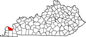
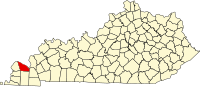
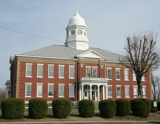
Carlisle County is a county located in the U.S. state of Kentucky. As of the 2020 census, the population was 4,826, making it the fourth-least populous county in Kentucky. Its county seat is Bardwell. The county was founded in 1886 and named for John Griffin Carlisle, a Speaker of the United States House of Representatives from Kentucky. It remains a prohibition or dry county. Carlisle County is included in the Paducah, KY-IL, Metropolitan Statistical Area.

<span class="mw-page-title-main">Ballard County, Kentucky</span> County in Kentucky, United States

Ballard County is a county located in the west portion of the U.S. state of Kentucky. As of the 2020 census, the population was 7,728. Its county seat is Wickliffe and its largest city is LaCenter. The county was created by the Kentucky State Legislature in 1842 and is named for Captain Bland Ballard, a soldier, statesman, and member of the Kentucky General Assembly. Ballard County is part of the Paducah, KY-IL Metropolitan Statistical Area.

<span class="mw-page-title-main">Pope County, Illinois</span> County in Illinois, United States

Pope County is the southeasternmost county in the U.S. state of Illinois. According to the 2020 census, it had a population of 3,763, making it the second-least populous county in Illinois. Its county seat is Golconda. The county was organized in 1816 from portions of Gallatin and Johnson counties and named after Nathaniel Pope, a politician and jurist from the Illinois Territory and State of Illinois.

<span class="mw-page-title-main">Massac County, Illinois</span> County in Illinois, United States

Massac County is a county in the U.S. state of Illinois. According to the 2020 census, it had a population of 14,169. Established in 1843 and named for a French fort founded in the 18th century, its county seat is Metropolis. Massac County is included in the Paducah, KY-IL Metropolitan Statistical Area. It is located along the Ohio River, in the portion of the state known locally as "Little Egypt".

<span class="mw-page-title-main">Johnson County, Illinois</span> County in Illinois, United States

Johnson County is a county in the U.S. state of Illinois. According to the 2020 census, it has a population of 13,308. Its county seat is Vienna. It is located in the southern portion of Illinois known locally as "Little Egypt".

<span class="mw-page-title-main">Brookport, Illinois</span> City in Illinois, United States

Brookport is a city in Massac County, Illinois, United States. The population was 725 at the 2020 census, down from 984 in 2010. It is part of the Paducah, KY-IL Metropolitan Statistical Area.

<span class="mw-page-title-main">Joppa, Illinois</span> Village in Illinois, United States

Joppa is a village in Massac County, Illinois, United States, along the Ohio River. The population was 350 as of the 2020 census. It is part of the Paducah, KY-IL Metropolitan Statistical Area.

<span class="mw-page-title-main">Metropolis, Illinois</span> City in Illinois, United States

Metropolis is a city located along the Ohio River in Massac County, Illinois, United States. As of the 2020 census, it had a population of 5,969, down from 6,537 in 2010. Metropolis is the county seat of Massac County and is part of the Paducah, KY-IL Micropolitan Statistical Area in Southern Illinois.

<span class="mw-page-title-main">Kevil, Kentucky</span> City in Kentucky, United States

Kevil is a home rule-class city in Ballard County, Kentucky, United States. The population was 595 as of the 2020 census, It is part of the Paducah KY-IL Metropolitan Statistical Area.

<span class="mw-page-title-main">Carrsville, Kentucky</span> City in Kentucky, United States

Carrsville is a home rule-class city beside the Ohio River in Livingston County, Kentucky, in the United States. The population was 50 at the 2010 census, declining from 64 as of 2000. It is part of the Paducah, KY-IL Metropolitan Statistical Area. It is situated just west of the junction of where Buck Creek empties into the Ohio River.

<span class="mw-page-title-main">Ledbetter, Kentucky</span> CDP in Kentucky, United States

Ledbetter is a census-designated place (CDP) in Livingston County, Kentucky, United States. The population was 1,683 at the 2010 census, down slightly from 1,700 in 2000, thus making it the largest and most populous community in Livingston County. It is part of the Paducah, KY-IL Micropolitan Statistical Area, laying directly across the Tennessee River from Paducah.

<span class="mw-page-title-main">Hendron, Kentucky</span> Census-designated place in Kentucky, United States

Hendron is an unincorporated community and census-designated place (CDP) in McCracken County, Kentucky, United States. The population was 4,774 at the 2020 census. It is part of the Paducah, KY-IL Metropolitan Statistical Area.

<span class="mw-page-title-main">Lone Oak, Kentucky</span> Unincorporated community in Kentucky, United States

Lone Oak is an unincorporated community and former city in McCracken County, Kentucky, United States. The population was 454 at the 2000 census, the last before its disincorporation. It is a part of the Paducah, KY-IL Metropolitan Statistical Area.

<span class="mw-page-title-main">Massac, Kentucky</span> Census-designated place in Kentucky, United States

Massac is a census-designated place (CDP) in McCracken County, Kentucky, United States. The population was 4,635 at the 2020 census. It is part of the Paducah, KY-IL Metropolitan Statistical Area.

<span class="mw-page-title-main">Paducah, Kentucky</span> City in Kentucky, United States

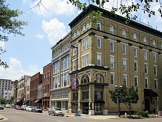
Paducah is a home rule-class city in and the county seat of McCracken County, Kentucky, United States. The largest city in the Jackson Purchase region, it is located in the Southeastern United States at the confluence of the Tennessee and the Ohio rivers, halfway between St. Louis, Missouri, to the northwest and Nashville, Tennessee, to the southeast. As of the 2020 census, the population was 27,137, up from 25,024 in 2010. Twenty blocks of the city's downtown have been designated as a historic district and listed on the National Register of Historic Places.

Reidland is an unincorporated community and census-designated place (CDP) in McCracken County, Kentucky, United States. The population was 4,526 at the 2020 census. It is part of the Paducah, KY-IL Metropolitan Statistical Area.

The Paducah, KY–IL Metropolitan Statistical Area, as defined by the United States Census Bureau, is an area consisting of five counties – three in the Jackson Purchase region of Kentucky, a fourth Kentucky county bordering the Purchase, and one in Southern Illinois – anchored by the city of Paducah, Kentucky. The Paducah KY-IL Micropolitan Statistical Area was upgraded to Metropolitan Statistical Area (MSA) status on July 21, 2023, by the Office of Management and Budget.. Carlisle County, Kentucky, was added to the area following the 2020 Census of the Population. The total MSA population from the 2020 United States Census was 103,486.

<span class="mw-page-title-main">Farley, Kentucky</span> Census-designated place in Kentucky, United States

Farley is a census-designated place (CDP) in McCracken County, Kentucky, United States. The population was 4,374 as of the 2020 census, down from 4,701 in 2010. It is part of the Paducah, KY-IL Metropolitan Statistical Area. The area was listed by the U.S. Census Bureau as Woodlawn-Oakdale starting with the 1980 census and as Farley starting with the 2010 census.

References

  1. 1 2 "State & County QuickFacts". United States Census Bureau. Retrieved June 30, 2022.
  2. "Find a County". National Association of Counties. Archived from the original on May 31, 2011. Retrieved June 7, 2011.
  3. Collins, Lewis (1877). History of Kentucky. p. 593. ISBN   9780722249208.
  4. E., Kleber, John; Kentucky, University Press of; Policy, Institute for Regional Analysis and Public; Library, Camden-Carroll; University, Morehead State (2000). "The Kentucky Encyclopedia". www.kyenc.org. Retrieved July 4, 2018.{{cite web}}: |last3= has generic name (help)CS1 maint: multiple names: authors list (link)
  5. The Register of the Kentucky State Historical Society, Volume 1. Kentucky State Historical Society. 1903. pp.  36.
  6. "2010 Census Gazetteer Files". United States Census Bureau. August 22, 2012. Archived from the original on August 12, 2014. Retrieved August 17, 2014.
  7. "Annual Estimates of the Resident Population for Counties: April 1, 2020 to July 1, 2023". United States Census Bureau. Retrieved March 14, 2024.
  8. "U.S. Decennial Census". United States Census Bureau. Retrieved August 17, 2014.
  9. "Historical Census Browser". University of Virginia Library. Retrieved August 17, 2014.
  10. "Population of Counties by Decennial Census: 1900 to 1990". United States Census Bureau. Retrieved August 17, 2014.
  11. "Census 2000 PHC-T-4. Ranking Tables for Counties: 1990 and 2000" (PDF). United States Census Bureau. Archived (PDF) from the original on October 9, 2022. Retrieved August 17, 2014.
  12. "U.S. Census website". United States Census Bureau . Retrieved January 31, 2008.
  13. Leip, David. "Dave Leip's Atlas of U.S. Presidential Elections". uselectionatlas.org. Retrieved July 4, 2018.

37°04′N88°43′W / 37.06°N 88.72°W / 37.06; -88.72