Livingston County, Kentucky

Last updated

Livingston County
Livingston County Courthouse, Smithland.jpg
Livingston County Courthouse in Smithland
Map of Kentucky highlighting Livingston County.svg
Location within the U.S. state of Kentucky
Kentucky in United States.svg
Kentucky's location within the U.S.
Coordinates: 37°13′N88°21′W / 37.21°N 88.35°W / 37.21; -88.35
CountryFlag of the United States.svg United States
StateFlag of Kentucky.svg  Kentucky
Founded1798
Named for Robert R. Livingston
Seat Smithland
Largest community Ledbetter
Area
  Total342 sq mi (890 km2)
  Land313 sq mi (810 km2)
  Water29 sq mi (80 km2)  8.5%
Population
 (2020)
  Total8,888
  Estimate 
(2023)
8,892 Increase2.svg
  Density26/sq mi (10/km2)
Time zone UTC−6 (Central)
  Summer (DST) UTC−5 (CDT)
Congressional district 1st
Website livingstoncountyky.com

Livingston County is a county located in the U.S. state of Kentucky. As of the 2020 census, the population was 8,888. [1] Its county seat is Smithland and its largest community is Ledbetter. [2] The county was established in 1798 from land taken from Christian County and is named for Robert R. Livingston, a member of the Committee of Five that drafted the U.S. Declaration of Independence. [3] The county was strongly pro-Confederate during the American Civil War and many men volunteered for the Confederate Army. [4] [5] Livingston County is part of the Paducah, KY-IL Metropolitan Statistical Area. It is a prohibition or dry county with the exception of Grand Rivers which voted to allow alcohol sales in 2016. [6]

Contents

History

Geography

According to the U.S. Census Bureau, the county has a total area of 342 square miles (890 km2), of which 313 square miles (810 km2) is land and 29 square miles (75 km2) (8.5%) is water. [7] The western border with Illinois is formed by the Ohio River.

Adjacent counties

Major highways

Demographics

Historical population
CensusPop.Note
1800 2,856
1810 3,67428.6%
1820 5,82458.5%
1830 5,9712.5%
1840 9,02551.1%
1850 6,578−27.1%
1860 7,2139.7%
1870 8,20013.7%
1880 9,16511.8%
1890 9,4743.4%
1900 11,35419.8%
1910 10,627−6.4%
1920 9,732−8.4%
1930 8,608−11.5%
1940 9,1276.0%
1950 7,184−21.3%
1960 7,029−2.2%
1970 7,5968.1%
1980 9,21921.4%
1990 9,062−1.7%
2000 9,8048.2%
2010 9,519−2.9%
2020 8,888−6.6%
2023 (est.)8,892 [8] 0.0%
U.S. Decennial Census [9]
1790-1960 [10] 1900-1990 [11]
1990-2000 [12] 2010-2021 [13]

As of the census [14] of 2010, there were 9,519 people living in the county. The population density was 31 per square mile (12/km2). There were 4,772 housing units at an average density of 15 per square mile (5.8/km2). The racial makeup of the county was 98.49% White, 0.14% Black or African American, 0.42% Native American, 0.03% Asian, 0.01% Pacific Islander, 0.28% from other races, and 0.63% from two or more races. 0.75% of the population were Hispanics or Latinos of any race.

There were 3,996 households, out of which 29.50% had children under the age of 18 living with them, 60.40% were married couples living together, 7.90% had a female householder with no husband present, and 27.60% were non-families. 24.40% of all households were made up of individuals, and 11.00% had someone living alone who was 65 years of age or older. The average household size was 2.42 and the average family size was 2.86.

The age distribution was 22.30% under the age of 18, 7.50% from 18 to 24, 28.20% from 25 to 44, 27.00% from 45 to 64, and 14.90% who were 65 years of age or older. The median age was 40 years. For every 100 females, there were 97.80 males. For every 100 females age 18 and over, there were 97.70 males.

The median income for a household in the county was $31,776, and the median income for a family was $39,486. Males had a median income of $33,633 versus $19,617 for females. The per capita income for the county was $17,072. About 7.60% of families and 10.30% of the population were below the poverty line, including 10.70% of those under age 18 and 15.80% of those age 65 or over.

Communities

Cities

Census-designated places

Other unincorporated communities

North Livingston

South Livingston

Ghost Town

Notable people

Politics

United States presidential election results for Livingston County, Kentucky [15]
Year Republican Democratic Third party
No.%No.%No.%
2020 4,01080.14%93918.76%551.10%
2016 3,57076.86%88719.10%1884.05%
2012 3,08968.48%1,34629.84%761.68%
2008 2,89062.92%1,62235.31%811.76%
2004 2,67556.84%2,00742.65%240.51%
2000 2,11850.07%2,02247.80%902.13%
1996 1,25831.70%2,22856.15%48212.15%
1992 1,33931.05%2,38655.33%58713.61%
1988 1,83446.92%2,05252.49%230.59%
1984 1,86647.96%2,00751.58%180.46%
1980 1,67041.67%2,28757.06%511.27%
1976 87825.71%2,49773.12%401.17%
1972 1,67359.96%1,06538.17%521.86%
1968 1,07932.63%1,27238.46%95628.91%
1964 82127.56%2,14772.07%110.37%
1960 1,63951.92%1,51848.08%00.00%
1956 1,24740.94%1,79558.93%40.13%
1952 1,10241.48%1,55458.49%10.04%
1948 67128.81%1,62269.64%361.55%
1944 1,20241.56%1,68658.30%40.14%
1940 1,18436.85%2,01362.65%160.50%
1936 1,03935.26%1,89764.37%110.37%
1932 1,07032.31%2,23167.36%110.33%
1928 1,76759.12%1,21740.72%50.17%
1924 1,26740.84%1,76857.00%672.16%
1920 1,79047.30%1,93351.08%611.61%
1916 92340.04%1,28755.84%954.12%
1912 73235.11%1,00948.39%34416.50%

See also

Related Research Articles

<span class="mw-page-title-main">McCracken County, Kentucky</span> County in Kentucky, United States

McCracken County is a county located in the far west portion of U.S. state of Kentucky. As of the 2020 census, the population was 67,875. The county seat and only municipality is Paducah. McCracken County was the 78th county formed in the state, having been created in 1825. It is part of the historic Jackson Purchase, territory sold by the Chickasaw people to General Andrew Jackson and Governor Isaac Shelby; this territory was located at the extreme western end of Kentucky.

<span class="mw-page-title-main">Rockcastle County, Kentucky</span> County in Kentucky, United States

Rockcastle County is a county located in the southeastern part of the U.S. state of Kentucky. As of the 2020 census, the population was 16,037. Its county seat is Mt. Vernon. The county was founded in 1810 and named for the Rockcastle River, which runs through it. The river, in turn, is named for its majestic rock cliffs. Rockcastle County is part of the Richmond-Berea, KY Micropolitan Statistical Area, which is also included in the Lexington-Fayette–Richmond–Frankfort, KY combined statistical area.

<span class="mw-page-title-main">Lyon County, Kentucky</span> County in Kentucky, United States

Lyon County is a county located in the U.S. state of Kentucky. As of the 2020 census, the population was 8,680. Its county seat is Eddyville. The county was formed from Caldwell County, Kentucky in 1854 and named for former Congressman Chittenden Lyon.

<span class="mw-page-title-main">Crittenden County, Kentucky</span> County in Kentucky, United States

Crittenden County is a county in the U.S. state of Kentucky. At the 2020 census, the population was 8,990. Its county seat and only municipality is Marion. The county was formed in 1842 and named for John J. Crittenden, senator and future Governor of Kentucky.

<span class="mw-page-title-main">Scott County, Illinois</span> County in Illinois, United States

Scott County is a county located in the U.S. state of Illinois. According to the 2020 census, it had a population of 4,949, making it the fourth-least populous county in Illinois. Its county seat is Winchester.

<span class="mw-page-title-main">Pope County, Illinois</span> County in Illinois, United States

Pope County is the southeasternmost county in the U.S. state of Illinois. According to the 2020 census, it had a population of 3,763, making it the second-least populous county in Illinois. Its county seat is Golconda. The county was organized in 1816 from portions of Gallatin and Johnson counties and named after Nathaniel Pope, a politician and jurist from the Illinois Territory and State of Illinois.

<span class="mw-page-title-main">Hardin County, Illinois</span> County in Illinois, United States

Hardin County is a county located in the U.S. state of Illinois. According to the 2020 census, it has a population of 3,649, making it the least populous county in Illinois. Its county seat is Elizabethtown. Hardin County is located in the part of the state known as Little Egypt. Hardin County was named for Hardin County, Kentucky, which was named in honor of Colonel John Hardin, an officer in the American Revolutionary War and the Northwest Indian War.

<span class="mw-page-title-main">Livingston, Illinois</span> Village in Illinois, United States

Livingston is a village in Madison County, Illinois, United States. The population was 763 at the 2020 census, down from 858 in 2010.

<span class="mw-page-title-main">Smithland, Iowa</span> City in Iowa, United States

Smithland is a city in Woodbury County, Iowa, United States. It is part of the Sioux City, IA–NE–SD Metropolitan Statistical Area. The population was 181 at the time of the 2020 census.

<span class="mw-page-title-main">Blandville, Kentucky</span> Inactive city in Kentucky, United States

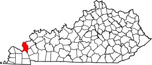
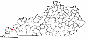
Blandville is an inactive home rule-class city in Ballard County, Kentucky, in the United States. It was founded in 1842 and named for Captain Bland Ballard, a hero of the War of 1812. It was formally incorporated by the state assembly in 1845. Blandville was the seat of Ballard County from 1842 to 1881, when the seat was moved to Wickliffe. The population was 73 as of the 2020 census. It is part of the Paducah, KY-IL Metropolitan Statistical Area.

<span class="mw-page-title-main">Bardwell, Kentucky</span> City in Kentucky, United States

Bardwell is a home rule-class city in and the county seat of Carlisle County, Kentucky, United States. The city was formally incorporated by the state assembly in 1878. The population was 714 at the 2020 census, down from 723 in 2010. Bardwell is included in the Paducah, KY-IL Metropolitan Statistical Area.

<span class="mw-page-title-main">Dycusburg, Kentucky</span> Unincorporated community in Kentucky, United States

Dycusburg is an unincorporated community in Crittenden County, Kentucky, United States. The population was 26 at the 2010 census.

<span class="mw-page-title-main">Carrsville, Kentucky</span> City in Kentucky, United States

Carrsville is a home rule-class city beside the Ohio River in Livingston County, Kentucky, in the United States. The population was 50 at the 2010 census, declining from 64 as of 2000. It is part of the Paducah, KY-IL Metropolitan Statistical Area. It is situated just west of the junction of where Buck Creek empties into the Ohio River.

<span class="mw-page-title-main">Grand Rivers, Kentucky</span> City in Kentucky, United States

Grand Rivers is a home rule-class city in Livingston County, Kentucky, in the United States. The population was 382 at the 2010 census, up from 343 in 2000. It is part of the Paducah, KY-IL Metropolitan Statistical Area.

<span class="mw-page-title-main">Ledbetter, Kentucky</span> CDP in Kentucky, United States

Ledbetter is a census-designated place (CDP) in Livingston County, Kentucky, United States. The population was 1,683 at the 2010 census, down slightly from 1,700 in 2000, thus making it the largest and most populous community in Livingston County. It is part of the Paducah, KY-IL Micropolitan Statistical Area, laying directly across the Tennessee River from Paducah.

<span class="mw-page-title-main">Salem, Kentucky</span> City in Kentucky, United States

Salem is a home rule-class city in Livingston County, Kentucky, in the United States. Salem is part of the Paducah, KY-IL metropolitan statistical area. The population was 752 during the 2010 census, down from 769 in 2000. It the second-largest community in Livingston County, but the census-designated place of Ledbetter has more than twice the population of Salem.

<span class="mw-page-title-main">Smithland, Kentucky</span> City in Kentucky, United States

Smithland is a home rule-class city in Livingston County, Kentucky, United States, at the confluence of the Ohio and Cumberland Rivers. The population was 301 at the 2010 census, a drop from 401 in 2000. It is the county seat of Livingston County.

Reidland is an unincorporated community and census-designated place (CDP) in McCracken County, Kentucky, United States. The population was 4,526 at the 2020 census. It is part of the Paducah, KY-IL Metropolitan Statistical Area.

The Paducah, KY-IL Micropolitan Statistical Area, as defined by the United States Census Bureau, is an area consisting of five counties – three in the Jackson Purchase region of Kentucky, a fourth Kentucky county bordering the Purchase, and one in southern Illinois – anchored by the city of Paducah, Kentucky. The Paducah KY-IL Micropolitan Statistical Area was upgraded to Metropolitan Statistical Area (MSA) status on July 21, 2023, by the Office of Management and Budget.. Carlisle County, Kentucky, was added to the area following the 2020 Census of the Population. The total MSA population from the 2020 United States Census was 103,486.

<span class="mw-page-title-main">Farley, Kentucky</span> Census-designated place in Kentucky, United States

Farley is a census-designated place (CDP) in McCracken County, Kentucky, United States. The population was 4,374 as of the 2020 census, down from 4,701 in 2010. It is part of the Paducah, KY-IL Metropolitan Statistical Area. The area was listed by the U.S. Census Bureau as Woodlawn-Oakdale starting with the 1980 census and as Farley starting with the 2010 census.

References

  1. "Census - Geography Profile: Livingston County, Kentucky". United States Census Bureau . Retrieved December 30, 2022.
  2. "Find a County". National Association of Counties. Retrieved June 7, 2011.
  3. Collins, Lewis (1877). History of Kentucky. p. 478. ISBN   9780722249208.
  4. Collins, Lewis (1882). Collins' Historical Sketches of Kentucky: History of Kentucky, Volume 2. Collins & Company. p. 26.
  5. The Register of the Kentucky State Historical Society, Volume 1. Kentucky State Historical Society. 1903. pp.  36.
  6. Fuller, Leanne. "Voters decide to allow alcohol sales in Grand Rivers". WPSD Local 6. Retrieved November 15, 2021.
  7. "2010 Census Gazetteer Files". United States Census Bureau. August 22, 2012. Archived from the original on August 12, 2014. Retrieved August 17, 2014.
  8. "Annual Estimates of the Resident Population for Counties: April 1, 2020 to July 1, 2023". United States Census Bureau. Retrieved March 14, 2024.
  9. "U.S. Decennial Census". United States Census Bureau. Retrieved August 17, 2014.
  10. "Historical Census Browser". University of Virginia Library. Retrieved August 17, 2014.
  11. "Population of Counties by Decennial Census: 1900 to 1990". United States Census Bureau. Retrieved August 17, 2014.
  12. "Census 2000 PHC-T-4. Ranking Tables for Counties: 1990 and 2000" (PDF). United States Census Bureau. Archived (PDF) from the original on March 27, 2010. Retrieved August 17, 2014.
  13. "State & County QuickFacts". United States Census Bureau. Archived from the original on June 7, 2011. Retrieved March 6, 2014.
  14. "U.S. Census website". United States Census Bureau . Retrieved January 31, 2008.
  15. Leip, David. "Dave Leip's Atlas of U.S. Presidential Elections". uselectionatlas.org. Retrieved July 4, 2018.

37°13′N88°21′W / 37.21°N 88.35°W / 37.21; -88.35