Wolfe County, Kentucky

Last updated

Wolfe County
Wolfe County, Kentucky courthouse.jpg
Wolfe County courthouse in Campton
Map of Kentucky highlighting Wolfe County.svg
Location within the U.S. state of Kentucky
Kentucky in United States.svg
Kentucky's location within the U.S.
Coordinates: 37°44′N83°29′W / 37.74°N 83.49°W / 37.74; -83.49
CountryFlag of the United States.svg United States
StateFlag of Kentucky.svg  Kentucky
Founded1860
Named for The Wolfe family out of Western North Carolina
Seat Campton
Largest cityCampton
Area
  Total223 sq mi (580 km2)
  Land222 sq mi (570 km2)
  Water0.6 sq mi (2 km2)  0.3%
Population
 (2020)
  Total6,562
  Estimate 
(2023)
6,282 Decrease2.svg
  Density29/sq mi (11/km2)
Time zone UTC−5 (Eastern)
  Summer (DST) UTC−4 (EDT)
Congressional district 6th

Wolfe County is a county located in the U.S. state of Kentucky. As of the 2020 census, the population was 6,562. [1] Its county seat is Campton. [2] The county is named for Nathaniel Wolfe.

Contents

History

Wolfe County was formed on March 5, 1860, from portions of Breathitt County, Morgan County, Owsley County and Powell County. It was named for Nathaneal Wolfe, a member of the legislative assembly. [3]

Campton, the county's seat was reportedly formed from camp town in Wolfe County. A small creek winding through Campton, Swift Creek, is named after Jonathan Swift of the legend of Swift's silver mine. Swift supposedly buried treasure in the area which has never been recovered.

Geography

According to the U.S. Census Bureau, the county has a total area of 223 square miles (580 km2), of which 222 square miles (570 km2) is land and 0.6 square miles (1.6 km2) (0.3%) is water. [4]

Adjacent counties

National protected area

State protected area

Demographics

Historical population
CensusPop.Note
1870 3,603
1880 5,63856.5%
1890 7,18027.4%
1900 8,76422.1%
1910 9,86412.6%
1920 8,783−11.0%
1930 8,425−4.1%
1940 9,99718.7%
1950 7,615−23.8%
1960 6,534−14.2%
1970 5,669−13.2%
1980 6,69818.2%
1990 6,503−2.9%
2000 7,0658.6%
2010 7,3554.1%
2020 6,562−10.8%
2023 (est.)6,282 [5] −4.3%
U.S. Decennial Census [6]
1790-1960 [7] 1900-1990 [8]
1990-2000 [9] 2010-2021 [10]

As of the census [11] of 2000, there were 7,065 people, 2,816 households, and 1,976 families residing in the county. The population density was 32 per square mile (12/km2). There were 3,264 housing units at an average density of 15 per square mile (5.8/km2). The racial makeup of the county was 99.24% White, 0.24% Black or African American, 0.08% Native American, 0.03% Asian, 0.03% Pacific Islander, 0.06% from other races, and 0.33% from two or more races. 0.51% of the population were Hispanic or Latino of any race.

There were 2,816 households, out of which 33.60% had children under the age of 18 living with them, 52.30% were married couples living together, 12.50% had a female householder with no husband present, and 29.80% were non-families. 27.00% of all households were made up of individuals, and 9.70% had someone living alone who was 65 years of age or older. The average household size was 2.45 and the average family size was 2.96.

In the county, the population was spread out, with 25.90% under the age of 18, 9.40% from 18 to 24, 28.50% from 25 to 44, 23.50% from 45 to 64, and 12.70% who were 65 years of age or older. The median age was 36 years. For every 100 females there were 98.50 males. For every 100 females age 18 and over, there were 96.10 males.

The median income for a household in the county was $19,310, and the median income for a family was $23,333. Males had a median income of $23,859 versus $18,952 for females. The per capita income for the county was $10,321. About 29.90% of families and 35.90% of the population were below the poverty line, including 50.20% of those under age 18 and 26.70% of those age 65 or over.

Wolfe County is the poorest county in the United States, by median household income. [12]

Politics

Wolfe County, like most of Eastern Kentucky, is historically Democratic. In 2000, George W. Bush narrowly won the county and became the first Republican to do so, but the county still proved its Democratic loyalty by supporting John Kerry by a comfortable margin in the next election. However, the county has indeed drifted away from the Democrats at the presidential level as Mitt Romney won the county 60% to 30% in 2012, and Donald Trump with an even wider margin of 68% to 28%.

Wolfe remained reliably Democratic at the state level for some time after ceasing to favor the Democratic Party at the presidential level; it voted against Matt Bevin in both of his gubernatorial elections. Wolfe County has not voted for a Republican gubernatorial candidate since 1979 when it voted for Republican and former Governor Louie Nunn over Democrat John Y. Brown Jr. Along with nearby Elliott County, it was, until 2020, one of only two counties in Kentucky to have voted against Senator Mitch McConnell in each of his elections. In 2020, however, both counties voted for McConnell over his Democratic challenger, Amy McGrath. [13]

United States presidential election results for Wolfe County, Kentucky [14]
Year Republican Democratic Third party
No.%No.%No.%
2020 2,09770.39%83928.16%431.44%
2016 1,80468.46%75328.58%782.96%
2012 1,54260.26%97638.14%411.60%
2008 1,40847.44%1,49350.30%672.26%
2004 1,38543.90%1,74455.28%260.82%
2000 1,26752.25%1,13646.85%220.91%
1996 77233.61%1,29756.46%2289.93%
1992 69725.97%1,67462.37%31311.66%
1988 91636.94%1,51661.13%481.94%
1984 1,25746.68%1,39451.76%421.56%
1980 95133.90%1,81464.67%401.43%
1976 65926.81%1,77772.29%220.90%
1972 93648.83%95749.92%241.25%
1968 75834.35%1,16252.65%28713.00%
1964 56221.64%2,01877.71%170.65%
1960 1,25944.76%1,55455.24%00.00%
1956 1,05938.62%1,68361.38%00.00%
1952 87635.98%1,55763.94%20.08%
1948 81329.73%1,91870.13%40.15%
1944 88937.98%1,45061.94%20.09%
1940 1,03231.88%2,20568.12%00.00%
1936 97238.13%1,57761.87%00.00%
1932 90928.13%2,32171.81%20.06%
1928 1,27048.36%1,35651.64%00.00%
1924 82133.72%1,59765.59%170.70%
1920 93938.61%1,47660.69%170.70%
1916 64536.67%1,10862.99%60.34%
1912 39525.92%87357.28%25616.80%

Events

The annual Swift Silver Mine Festival is held on Labor Day weekend each year. It includes a parade and vendors in the downtown Campton area.

Communities

City

Census-designated place

Other unincorporated places

Notable people

See also

Related Research Articles

<span class="mw-page-title-main">Macon County, Tennessee</span> County in Tennessee, United States

Macon County is a county located in the U.S. state of Tennessee As of the 2020 census, the population was 25,216. Its county seat is Lafayette. Macon County is part of the Nashville-Davidson–Murfreesboro–Franklin, TN Metropolitan Statistical Area.

<span class="mw-page-title-main">Simpson County, Kentucky</span> County in Kentucky, United States

Simpson County is a county located in the south central portion of the U.S. state of Kentucky. As of the 2020 census, the total population was 19,594. Its county seat is Franklin.

<span class="mw-page-title-main">Rockcastle County, Kentucky</span> County in Kentucky, United States

Rockcastle County is a county located in the southeastern part of the U.S. state of Kentucky. As of the 2020 census, the population was 16,037. Its county seat is Mt. Vernon. The county was founded in 1810 and named for the Rockcastle River, which runs through it. The river, in turn, is named for its majestic rock cliffs. Rockcastle County is part of the Richmond-Berea, KY Micropolitan Statistical Area, which is also included in the Lexington-Fayette–Richmond–Frankfort, KY combined statistical area.

<span class="mw-page-title-main">Morgan County, Kentucky</span> County in Kentucky, United States

Morgan County is a county located in the U.S. state of Kentucky. As of the 2020 census, the population was 13,726. Its county seat is West Liberty. The county is among the dry counties, which means that the sale of alcohol is restricted or prohibited.

<span class="mw-page-title-main">Menifee County, Kentucky</span> County in Kentucky, United States

Menifee County is a county located in the U.S. state of Kentucky. As of the 2020 census, the population was 6,113, making it the fifth-least populous county in Kentucky. Its county seat is Frenchburg. The county is named for Richard Hickman Menefee, U.S. Congressman, although the spelling has changed. It is a prohibition or dry county. Menifee County is part of the Mount Sterling, KY Micropolitan Statistical Area, which is also included in the Lexington-Fayette–Richmond–Frankfort, KY combined statistical area. It is located in the foothills of the Cumberland Plateau.

<span class="mw-page-title-main">Magoffin County, Kentucky</span> County in Kentucky, United States

Magoffin County is a county located in the U.S. state of Kentucky. As of the 2020 census, the population was 11,637. Its county seat is Salyersville. The county was formed in 1860 from adjacent portions of Floyd, Johnson, and Morgan Counties. It was named for Beriah Magoffin who was Governor of Kentucky (1859–62).

<span class="mw-page-title-main">Lincoln County, Kentucky</span> County in Kentucky, United States

Lincoln County is a county located in south-central Kentucky. As of the 2020 census, the population was 24,275. Its county seat is Stanford. Lincoln County is part of the Danville, KY Micropolitan Statistical Area.

<span class="mw-page-title-main">Lee County, Kentucky</span> County in Kentucky, United States

Lee County is a county located in the U.S. state of Kentucky. As of the 2020 census, the population was 7,395. Its county seat is Beattyville. The county was formed in 1870 from parts of Breathitt, Estill, Owsley and Wolfe counties. The county was named for Robert E. Lee. The area of Kentucky where Lee County is located was a pro-union region of Kentucky but the legislature that created the county was controlled by former Confederates. The town of Proctor, named for the Rev. Joseph Proctor, was the first county seat. The first court was held on April 25, 1870, in the old Howerton House. The local economy at the time included coal mining, salt gathering, timber operations, and various commercial operations. It had a U.S. post office from 1843 until 1918.

<span class="mw-page-title-main">Knott County, Kentucky</span> County in Kentucky, United States

Knott County is a county located in the U.S. state of Kentucky. As of the 2020 census, the population was 14,251. Its county seat is Hindman. The county was formed in 1884 and is named for James Proctor Knott, Governor of Kentucky (1883–1887). It is a prohibition or dry county. Its county seat is home to the Hindman Settlement School, founded as America's first settlement school. The Knott County town of Pippa Passes is home to Alice Lloyd College.

<span class="mw-page-title-main">Elliott County, Kentucky</span> County in Kentucky, United States

Elliott County is a county located in the U.S. state of Kentucky. Its county seat is Sandy Hook. The county was formed in 1869 from parts of Morgan, Lawrence, and Carter counties, and is named for John Milton Elliott a judge, U.S. Congressman, and a member of the 1st Confederate States Congress from Kentucky; he was also involved in the formation of the Confederate government of Kentucky. Some historians, however, contend the county was named after John Milton Elliot's father, John Lyle Elliot a U.S. Congressman and Confederate Justice of the Kentucky Court of Appeals. In regard to alcohol sales, Elliott County is a dry county, meaning the sale of alcoholic beverages is prohibited everywhere in the county.

<span class="mw-page-title-main">Casey County, Kentucky</span> County in Kentucky, United States

Casey County is a county located in the U.S. Commonwealth of Kentucky. As of the 2020 census, the population was 15,941. Its county seat is Liberty. The county was formed in 1806 from the western part of Lincoln County and named for Colonel William Casey, a pioneer settler who moved his family to Kentucky in 1779. It is the only Kentucky county entirely in the Knobs region. Casey County is home to annual Casey County Apple Festival, and is a prohibition or dry county. It is considered part of the Appalachian region of Kentucky.

<span class="mw-page-title-main">Carroll County, Kentucky</span> County in Kentucky, United States

Carroll County is a county located in the northern part of the U.S. state of Kentucky. Its county seat is Carrollton. The county was formed in 1838 and named for Charles Carroll of Carrollton, the last living signer of the Declaration of Independence. It is located at the confluence of the Kentucky and Ohio Rivers.

<span class="mw-page-title-main">Breathitt County, Kentucky</span> County in Kentucky, United States

Breathitt County is a county in the eastern Appalachian portion of the U.S. state of Kentucky. As of the 2020 census, the population was 13,718. Its county seat is Jackson. The county was formed in 1839 and was named for John Breathitt, who was Governor of Kentucky from 1832 to 1834. Breathitt County was a prohibition or dry county, until a public vote in July 2016 that allowed alcohol sales.

<span class="mw-page-title-main">Bath County, Kentucky</span> County in Kentucky, United States

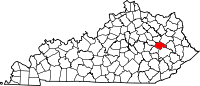
Bath County is a county located in the U.S. state of Kentucky. As of the 2020 census, the population was 12,750. The county seat is Owingsville. The county was formed in 1811. Bath County is included in the Mount Sterling, KY Micropolitan Statistical Area, which is also included in the Lexington-Fayette–Richmond–Frankfort, KY combined statistical area.

<span class="mw-page-title-main">Jackson, Kentucky</span> City in Kentucky, United States

Jackson is a home rule-class city in and the county seat of Breathitt County, Kentucky, in the United States. The population was 2,231 according to the 2010 U.S. census.

<span class="mw-page-title-main">Hazel, Kentucky</span> City in Kentucky, United States

Hazel is a home rule-class city in Calloway County, Kentucky, United States. The population was 410 at the 2010 census.

<span class="mw-page-title-main">Albany, Kentucky</span> City in Kentucky, United States

Albany is a home rule-class city in Clinton County, Kentucky, in the United States. The population was 2,033 at the 2010 census. It is the county seat of Clinton County. It is located on U.S. Route 127, about 6 miles (10 km) north of the Tennessee border.

<span class="mw-page-title-main">Campton, Kentucky</span> City in Kentucky, United States

Campton is a home rule-class city in and the county seat of Wolfe County, Kentucky, United States. The population was 441 at the 2010 census.

<span class="mw-page-title-main">Campton, New Hampshire</span> Town in New Hampshire, United States

Campton is a town in Grafton County, New Hampshire, United States. The population was 3,343 at the 2020 census. Campton, which includes the villages of Blair, Campton Hollow, Lower Campton and West Campton, is home to Blair State Forest and Livermore Falls State Forest. It is located in the foothills of the White Mountains, and parts of the White Mountain National Forest are in the northeast and northwest.

<span class="mw-page-title-main">Blakely, Pennsylvania</span> Borough in Pennsylvania, United States

Blakely is a borough in Lackawanna County, Pennsylvania, United States. It is part of Northeastern Pennsylvania. The population was 6,657 at the 2020 census.

References

  1. "Census - Geography Profile: Wolfe County, Kentucky". United States Census Bureau . Retrieved December 30, 2022.
  2. "Find a County". National Association of Counties. Retrieved June 7, 2011.
  3. The Register of the Kentucky State Historical Society, Volume 1. Kentucky State Historical Society. 1903. pp.  37.
  4. "2010 Census Gazetteer Files". United States Census Bureau. August 22, 2012. Archived from the original on August 12, 2014. Retrieved August 20, 2014.
  5. "Annual Estimates of the Resident Population for Counties: April 1, 2020 to July 1, 2023". United States Census Bureau. Retrieved March 14, 2024.
  6. "U.S. Decennial Census". United States Census Bureau. Retrieved August 20, 2014.
  7. "Historical Census Browser". University of Virginia Library. Retrieved August 20, 2014.
  8. "Population of Counties by Decennial Census: 1900 to 1990". United States Census Bureau. Retrieved August 20, 2014.
  9. "Census 2000 PHC-T-4. Ranking Tables for Counties: 1990 and 2000" (PDF). United States Census Bureau. Archived (PDF) from the original on March 27, 2010. Retrieved August 20, 2014.
  10. "State & County QuickFacts". United States Census Bureau. Archived from the original on September 5, 2015. Retrieved March 6, 2014.
  11. "U.S. Census website". United States Census Bureau . Retrieved January 31, 2008.
  12. "Explore Census Data".
  13. "2020 Kentucky Senate Results". Politico. Retrieved November 7, 2020.
  14. Leip, David. "Dave Leip's Atlas of U.S. Presidential Elections". uselectionatlas.org. Retrieved July 6, 2018.

37°44′N83°29′W / 37.74°N 83.49°W / 37.74; -83.49