Todd County, Kentucky

Last updated

Todd County
Todd County KY Courthouse.png
Todd County Courthouse
Map of Kentucky highlighting Todd County.svg
Location within the U.S. state of Kentucky
Kentucky in United States.svg
Kentucky's location within the U.S.
Coordinates: 36°50′N87°11′W / 36.84°N 87.18°W / 36.84; -87.18
CountryFlag of the United States.svg United States
StateFlag of Kentucky.svg  Kentucky
Founded1820
Named for John Todd
Seat Elkton
Largest cityElkton
Area
  Total377 sq mi (980 km2)
  Land374 sq mi (970 km2)
  Water2.6 sq mi (7 km2)  0.7%
Population
 (2020)
  Total12,243
  Estimate 
(2023)
12,494 Increase2.svg
  Density32/sq mi (13/km2)
Time zone UTC−6 (Central)
  Summer (DST) UTC−5 (CDT)
Congressional district 1st
Website www.toddcounty.ky.gov

Todd County is a county located in the U.S. state of Kentucky. As of the 2020 census, the population was 12,243. [1] Its county seat is Elkton. [2] The county is named for Colonel John Todd, who was killed at the Battle of Blue Licks in 1782 during the American Revolution. [3] [4]

Contents

History

Early history

Todd County consists of two geographical regions known historically as the high country to the north and low country to the south. The northern highlands consist of steep-sloped sandstone terrain with forests of oak, walnut and poplar. The landscape contains steep bluffs and sharp rises and falls within the terrain. The southern lowlands consist of rolling limestone flatlands void of aquifer sinks and consist of dense but sparse forests of oak, walnut poplar and ash. [5] The historic inhabitants of the region before European encounter were the Iroquoian language-speaking Cherokee, who had migrated centuries earlier from areas around the Great Lakes. They used the lands for hunting and gathering. [6]

Todd County lies within what was originally considered the western portion of the Commonwealth of Virginia. Many of the original white settlers came when the area was still considered part of Virginia. This part of southern Kentucky was designated to be awarded to Virginia veterans of the American Revolutionary War as payment for their services. [7]

Justinian Cartwright may have been the first settle in what is now Todd County. However, the first proven residents are Edward Shanklin Jr., Matthew and David Rolston, and John Huston and his sons James and Granville Huston. [8] Samuel Davis, father of Jefferson Davis, and John Wilson were also early settlers of the county. Kentucky Governor Greenup made the first Kentucky land grants to veterans William Croghan, David Logan, Edward Shanklin Jr., and John Wilson, among others. [6]

Todd County was created in response to a petition for "home government," since travel to the county seats of Logan and Christian was arduous. The petition had been written by the magisterial court, consisting of Edward Shanklin, John Gray, Robert Coleman, Henry Gorin, John Taylor, H. C. Ewing, John S Anderson, William Hopper, John Mann and Joseph Frazer, had made the request. [9] The legislature of the Commonwealth of Kentucky accordingly passed an act creating of the county from portions of Christian and Logan counties on April 1, 1820. The new county was named for Colonel John Todd, who had been killed at the Battle of Blue Licks in 1782. [6]

Development

Agriculture is a revered tradition in Todd County. The lowlands are of the finest rich soil types, including "Pembroke" soil. The lowlands are prized for their high growth yields. In the early 19th century, Major John Gray established a stagecoach hub in the county with travel routes radiating to larger American cities from the central point. His widely known Stagecoach Inn located in "Graysville," now Guthrie, Kentucky, was at the center of the travel routes. Major Gray's stagecoach empire was highly successful, and he soon became wealthy due to its popularity in the region. Major Gray built a house, a simple two-story shed-roofed, brick one-pile dwelling, now known as "Halcyon," or the John Gray House.

Gray wanted a town to be established near his home that would become the county seat. Gray designed the city, which included a town square from which hundreds of lots radiated. He called it "Elkton" after the elk herds that watered at a spring near the town center. Gray designed the town square as a trapezoid instead of a square, with the south side of the town square larger than the north so that as the sun traversed across the sky, the buildings on the east and west would benefit from prolonged periods of daily sunlight. Gray contributed funding for a county courthouse, which was erected at the center of the square. The brick building stood two stories with a cupola at the top.

After Major Gray died, the building was deemed in a state of ruin due to improper construction methods and torn down to erect a new courthouse. The new Todd County courthouse was erected by order of the Fiscal Court in 1834. R. Rowland designed the building in the Federal Style with an integration of Greek-Revival style motifs. The brick building, which is extant in the 21st century, stands two stories tall with tripartite windows and large Greek-Revival lintels. The building originally had a smaller federal style cupola, but this was later replaced with a late Victorian clock tower in the second Empire style, which remains today.

Civil War

Kentucky was a source of slaves for the cotton plantations in the lower South, and the slave trade was a profitable business for many Kentuckians. However, most Kentuckians did not own slaves. Those who did were wealthy plantation owners who stood to lose a lot if slavery were abolished. The major slave-owning areas in the state were the Bluegrass region, Henderson and Oldham counties on the Ohio River, and the western Kentucky counties of Trigg, Christian, Todd, and Warren. Many Kentuckians from these areas joined the Confederate army. Nevertheless, Kentucky's allegiance was divided during the Civil War. The state was officially neutral until September 1861, when it pledged its support to the Union. In response, a pro-Confederate Confederate government of Kentucky was formed by representatives from several Kentucky counties, with a second capital at Bowling Green.

Geography

According to the U.S. Census Bureau, the county has a total area of 377 square miles (980 km2), of which 374 square miles (970 km2) is land and 2.6 square miles (6.7 km2) (0.7%) is water. [10]

Adjacent counties

Demographics

Historical population
CensusPop.Note
1830 8,680
1840 9,99115.1%
1850 12,26822.8%
1860 11,575−5.6%
1870 12,6129.0%
1880 15,99426.8%
1890 16,8145.1%
1900 17,3713.3%
1910 16,488−5.1%
1920 15,694−4.8%
1930 13,520−13.9%
1940 14,2345.3%
1950 12,890−9.4%
1960 11,364−11.8%
1970 10,823−4.8%
1980 11,8749.7%
1990 10,940−7.9%
2000 11,9719.4%
2010 12,4604.1%
2020 12,243−1.7%
2023 (est.)12,494 [11] 2.1%
U.S. Decennial Census [12]
1790-1960 [13] 1900-1990 [14]
1990-2000 [15] 2010-2021 [16]

As of the census [17] of 2000, there were 11,971 people, 4,569 households, and 3,367 families residing in the county. The population density was 32 per square mile (12/km2). There were 5,121 housing units at an average density of 14 per square mile (5.4/km2). The racial makeup of the county was 89.32% White, 8.75% Black or African American, 0.15% Native American, 0.17% Asian, 0.03% Pacific Islander, 0.87% from other races, and 0.71% from two or more races. 1.66% of the population were Hispanic or Latino of any race.

There were 4,569 households, out of which 33.50% had children under the age of 18 living with them, 58.70% were married couples living together, 11.60% had a female householder with no husband present, and 26.30% were non-families. 23.00% of all households were made up of individuals, and 11.10% had someone living alone who was 65 years of age or older. The average household size was 2.59 and the average family size was 3.05.

In the county, the population was spread out, with 26.60% under the age of 18, 8.70% from 18 to 24, 28.40% from 25 to 44, 22.40% from 45 to 64, and 14.00% who were 65 years of age or older. The median age was 36 years. For every 100 females there were 94.80 males. For every 100 females age 18 and over, there were 92.70 males.

The median income for a household in the county was $29,718, and the median income for a family was $36,043. Males had a median income of $28,502 versus $20,340 for females. The per capita income for the county was $15,462. About 14.70% of families and 17.20% of the population were below the poverty line, including 21.90% of those under age 18 and 22.00% of those age 65 or over.

Attractions

Communities

Cities

Census-designated places

Other unincorporated communities

Notable residents

Politics

United States presidential election results for Todd County, Kentucky [19]
Year Republican Democratic Third party
No.%No.%No.%
2020 4,06275.74%1,20522.47%961.79%
2016 3,61275.58%1,04221.80%1252.62%
2012 3,24768.82%1,40329.74%681.44%
2008 3,33667.52%1,54331.23%621.25%
2004 3,24268.20%1,49131.36%210.44%
2000 2,64663.20%1,49635.73%451.07%
1996 1,91246.43%1,74442.35%46211.22%
1992 1,69140.24%1,85844.22%65315.54%
1988 2,28257.66%1,63241.23%441.11%
1984 2,36455.23%1,50535.16%4119.60%
1980 1,94548.86%1,95649.13%802.01%
1976 1,09530.44%2,43667.72%661.83%
1972 1,96459.25%1,22236.86%1293.89%
1968 1,43331.99%1,08224.16%1,96443.85%
1964 1,33932.73%2,73866.93%140.34%
1960 1,84639.50%2,82760.50%00.00%
1956 1,48032.28%3,08767.33%180.39%
1952 1,40131.73%2,99567.82%200.45%
1948 82720.45%2,92972.43%2887.12%
1944 1,36331.16%2,99068.36%210.48%
1940 1,43629.97%3,33769.64%190.40%
1936 1,17828.21%2,98771.53%110.26%
1932 1,56228.11%3,96671.38%280.50%
1928 2,49650.78%2,41649.16%30.06%
1924 1,94241.50%2,67957.24%591.26%
1920 2,66344.31%3,29254.78%550.92%
1916 1,67144.19%2,05154.24%591.56%
1912 1,43545.33%1,48246.81%2497.86%

See also

Related Research Articles

<span class="mw-page-title-main">Shelby County, Iowa</span> County in Iowa, United States

Shelby County is a county located in the U.S. state of Iowa. As of the 2020 census, the population was 11,746. The county seat is Harlan. Its name is in honor of Isaac Shelby, the first Governor of Kentucky.

<span class="mw-page-title-main">Cheyenne County, Nebraska</span> County in Nebraska, United States

Cheyenne County is a county in the U.S. state of Nebraska. As of the 2020 United States Census, the population was 9,468. Its county seat is Sidney. The county was formed in 1871 and named for the Cheyenne Native American tribe.

<span class="mw-page-title-main">Washington County, Kentucky</span> County in Kentucky, United States

Washington County is a county located in the U.S. state of Kentucky. As of the 2020 census, the population was 12,027. Its county seat is Springfield. The county is named for George Washington. Washington County was the first county formed in the Commonwealth of Kentucky when it reached statehood, and the sixteenth county formed. The center of population of Kentucky is located in Washington County, in the city of Willisburg. The county is dry, meaning that the sale of alcohol is prohibited, but it contains the "wet" city of Springfield, where retail alcohol sales are allowed. This classifies the jurisdiction as a moist county. Three wineries operate in the county and are licensed separately to sell to the public. Jacob Beam, founder of Jim Beam whiskey, sold his first barrel of whiskey in Washington County.

<span class="mw-page-title-main">Spencer County, Kentucky</span> County in Kentucky, United States

Spencer County is a county located in the U.S. state of Kentucky. As of the 2020 census, the total population was 19,490. Its county seat is Taylorsville. The county was founded in 1824 and named for Spier Spencer.

<span class="mw-page-title-main">Simpson County, Kentucky</span> County in Kentucky, United States

Simpson County is a county located in the south central portion of the U.S. state of Kentucky. As of the 2020 census, the total population was 19,594. Its county seat is Franklin.

<span class="mw-page-title-main">Logan County, Kentucky</span> County in Kentucky, United States

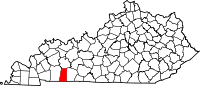
Logan County is a county in the southwest Pennyroyal Plateau area of the U.S. Commonwealth of Kentucky. As of the 2020 census, the population was 27,432. Its county seat is Russellville.

<span class="mw-page-title-main">Lawrence County, Kentucky</span> County in Kentucky, United States

Lawrence County is a county located in the U.S. state of Kentucky. As of the 2020 census, the population was 16,293. Its county seat is Louisa. The county is named for James Lawrence, and co-founded by Isaac Bolt, who served as a Lawrence County Commissioner and Justice of the Peace. Lawrence County is the home of bluegrass music and country music star Tyler Childers. It is the birthplace of the late Chief Justice of the United States Frederick Moore Vinson and former Kentucky Governor Paul E. Patton. In regard to alcoholic beverage sales, Lawrence County is considered a "moist" county, meaning alcohol sales are only allowed within the city limits of Louisa. There are no alcohol sales within the rest of the county. Only two stores sell liquor, and most convenience stores sell beer and malted beverages.

<span class="mw-page-title-main">Fleming County, Kentucky</span> County in Kentucky, United States

Fleming County is a county located in the U.S. state of Kentucky. As of the 2020 census, the population was 15,082. Its county seat is Flemingsburg. The county was formed in 1798 and named for Colonel John Fleming, an Indian fighter and early settler. It is a moist county. In 1998, the Kentucky General Assembly designated Fleming County as the Covered Bridge Capital of Kentucky.

<span class="mw-page-title-main">Crittenden County, Kentucky</span> County in Kentucky, United States

Crittenden County is a county in the U.S. state of Kentucky. At the 2020 census, the population was 8,990. Its county seat and only municipality is Marion. The county was formed in 1842 and named for John J. Crittenden, senator and future Governor of Kentucky.

<span class="mw-page-title-main">Christian County, Kentucky</span> County in Kentucky, United States

Christian County is a county located in the U.S. state of Kentucky. As of the 2020 census, the population was 72,748. Its county seat is Hopkinsville. The county was formed in 1797. Christian County is part of the Clarksville, Tennessee–Kentucky Metropolitan Statistical Area.

<span class="mw-page-title-main">Caldwell County, Kentucky</span> County in Kentucky, United States

Caldwell County is a county located in the U.S. state of Kentucky. As of the 2020 census, the population was 12,649. Its county seat is Princeton. The county was formed in 1809 from Livingston County, Kentucky and named for John Caldwell, who participated in the George Rogers Clark Indian Campaign of 1786 and was the second lieutenant governor of Kentucky. Caldwell was a prohibition or dry county until 2013, when the citizens voted to lift the ban.

<span class="mw-page-title-main">Bourbon County, Kentucky</span> County in Kentucky, United States

Bourbon County is a county located in the U.S. state of Kentucky. As of the 2020 census, the population was 20,252. Its county seat is Paris. Bourbon County is part of the Lexington-Fayette, KY Metropolitan Statistical Area. It is one of Kentucky's nine original counties, and is best known for its historical association with bourbon whiskey.

<span class="mw-page-title-main">Hardinsburg, Kentucky</span> City in Kentucky, United States

Hardinsburg is a home rule-class city in Breckinridge County, Kentucky, in the United States. It is the seat of its county. The population was 2,343 at the 2010 census. Hardinsburg was named after Captain William Hardin.

<span class="mw-page-title-main">Alexandria, Kentucky</span> City in Kentucky, United States

Alexandria is a home rule-class city in Campbell County, Kentucky, in the United States. Along with Newport, it is one of the dual seats of the county. The population was 10,341 at the 2020 census.

<span class="mw-page-title-main">Hustonville, Kentucky</span> City in Kentucky, United States

Hustonville is a home rule-class city in Lincoln County, Kentucky, in the United States. The population was 405 at the 2010 census. It is part of the Danville Micropolitan Statistical Area.

<span class="mw-page-title-main">Stanford, Kentucky</span> City in Kentucky, United States

Stanford is a home rule-class city in Lincoln County, Kentucky, United States. It is one of the oldest settlements in Kentucky, having been founded in 1775. Its population was 3,487 at the 2010 census and an estimated 3,686 in 2018. It is the county seat of Lincoln County. Stanford is part of the Danville Micropolitan Statistical Area.

<span class="mw-page-title-main">Lewisburg, Kentucky</span> City in Kentucky, United States

Lewisburg is a home rule-class city in Logan County, Kentucky, in the United States. The population was 810 at the 2010 census, down from 903 at the 2000 census.

<span class="mw-page-title-main">Greenville, Kentucky</span> City in Kentucky, United States

Greenville is a home rule-class city in Muhlenberg County, Kentucky, in the United States. It is the seat of its county. The population was 4,492 as of the 2020 census.

<span class="mw-page-title-main">Allensville, Kentucky</span> Unincorporated community in Kentucky, United States

Allensville is a census-designated place and former city in Todd County, Kentucky, in the United States. The population was 189 at the 2000 census. Settled in the 19th century and formally incorporated in 1867, the city was named for a pioneer family in the area. The city government was officially dissolved in 2017 after years of inactivity.

<span class="mw-page-title-main">Elkton, Kentucky</span> City in Kentucky, United States

Elkton is a home rule-class city in and the county seat of Todd County, Kentucky, United States. The population was 2,062 at the 2010 census.

References

  1. "Census - Geography Profile: Todd County, Kentucky". United States Census Bureau . Retrieved December 30, 2022.
  2. "Find a County". National Association of Counties. Retrieved June 7, 2011.
  3. The Register of the Kentucky State Historical Society, Volume 1. Kentucky State Historical Society. 1903. p. 37.
  4. "Origin of Todd County, Kentucky". kentuckygenealogy.org. July 7, 2015.
  5. "Groundwater Resources of Todd County, Kentucky". www.uky.edu.
  6. 1 2 3 Perrin, William Henry. History of Todd County, Kentucky. Chicago: F. A. Battey Publishing, 1884. Print.
  7. "Land Allocations after Revolutionary War" Archived 2007-11-07 at the Wayback Machine , Secretary of State, Virginia website
  8. Todd County, Kentucky Genealogy
  9. "Political Development of Todd County, Kentucky". kentuckygenealogy.org. July 7, 2015.
  10. "2010 Census Gazetteer Files". United States Census Bureau. August 22, 2012. Archived from the original on August 12, 2014. Retrieved August 20, 2014.
  11. "Annual Estimates of the Resident Population for Counties: April 1, 2020 to July 1, 2023". United States Census Bureau. Retrieved March 14, 2024.
  12. "U.S. Decennial Census". United States Census Bureau. Retrieved August 20, 2014.
  13. "Historical Census Browser". University of Virginia Library. Retrieved August 20, 2014.
  14. "Population of Counties by Decennial Census: 1900 to 1990". United States Census Bureau. Retrieved August 20, 2014.
  15. "Census 2000 PHC-T-4. Ranking Tables for Counties: 1990 and 2000" (PDF). United States Census Bureau. Archived (PDF) from the original on March 27, 2010. Retrieved August 20, 2014.
  16. "State & County QuickFacts". United States Census Bureau. Retrieved March 6, 2014.
  17. "U.S. Census website". United States Census Bureau . Retrieved January 31, 2008.
  18. "Kent Greenfield Stats - Baseball-Reference.com". Baseball-Reference.com.
  19. Leip, David. "Dave Leip's Atlas of U.S. Presidential Elections". uselectionatlas.org.

36°50′N87°11′W / 36.84°N 87.18°W / 36.84; -87.18