Barnby Dun

Last updated

Barnby Dun
Village
Barnby Dun with Kirk Sandall - Canal Bridge.jpg
Lifting bridge
South Yorkshire UK location map.svg
Red pog.svg
Barnby Dun
Location within South Yorkshire
  London 148 mi (238 km)
Civil parish
Metropolitan borough
Shire county
Metropolitan county
Region
Country England
Sovereign state United Kingdom
Post town Doncaster
Postcode district DN3
Dialling code 01302
Police South Yorkshire
Fire South Yorkshire
Ambulance Yorkshire
UK Parliament
List of places
UK
England
Yorkshire
53°34′N1°04′W / 53.57°N 1.07°W / 53.57; -1.07

Barnby Dun is a village in Doncaster, South Yorkshire, England. Together with Kirk Sandall it forms the civil parish of Barnby Dun with Kirk Sandall. It lies between Arksey and Stainforth. It is located about 4 miles north-east of Doncaster town centre.

Contents

Barnby Dun has a long history and was mentioned in the Domesday Book of 1086. [1] The village has a church dedicated to Saint Peter and Saint Paul, the structure of which dates back to the 13th century. Throughout its history, it has been a primarily agricultural village with later ties to industry; railways arrived at the village in the 1840s, and the nearby Thorpe Marsh Power Station opened in 1963. [2] Today, Barnby Dun is a residential area with a mix of modern and older properties.

There are local shops, a primary school, and recreational facilities, such as a village hall and playing fields, in the area. The village is known for its friendly community and good transport links to nearby towns and cities, making it a popular choice for families and commuters.

The parish church of St Peter & St Paul is Grade I listed. [3]

The village is located 21.3 miles (34.2 km) from Sheffield. [4] The village has 3,362 inhabitants (2016). [5] Barnby upon Don was a civil parish until 1921 when it became part of Barnby Dun with Kirk Sandall. [6] The civil parish had 774 inhabitants in 1921. [7]

Geology

The bedrock on which Barnby Dun is built is primarily sedimentary and composed of sandstone and gravel. The village sits atop the Chester Formation, the bedrock of which was formed around 247.1 million years ago during the Olenekian age of the Triassic period. Its parent rock unit is the Sherwood Sandstone Group.

In the newer parts of the village to the east, River Terrace Deposits are found dating to the present Quaternary period, composed primarily of sand and gravel. Late Pleistocene alluvium deposits can be found in the far west of the village around the River Don Navigation canal, due to silt, clay and gravel deposition on the River Don floodplain.

In a few areas in the north of the village, Pleistocene Glaciofluvial Deposits can be found dating to between 860 and 116 thousand years ago, likely corresponding to the Middle Pleistocene Glacial Maximum of 140 thousand years ago. The village is bounded to the north and west by the Hemingbrough Glaciolacustrine Formation of the Devensian Stage, deposits of which can be found within the parish of Barnby Dun at Thorpe Marsh. [8]

History

Pre-Norman era (pre–1066)

Evidence of farming upwards of 2,000 years ago has been discovered in the north of Barnby Dun near Ling House, where a brickwork pattern field system [9] was identified. One human cremation was also identified, potentially dating back further to the Bronze Age. [10]

Before the arrival of the Normans in 1066, there are mentioned in the Domesday Book three landholders. These were Anglo-Saxon men named Ulfkil, Ketilbert and Oswulf, the first of whom was lord of the manor and held two taxed bovates. [11] Ketilbert and Oswulf, however, both held nine bovates in the parish [12] [13] and a priest and church are named in the lands of Oswulf, constituting the first reference of a religious site in Barnby Dun. [14]

In the Domesday Book, Barnby Dun is referred to as "Barnebi", highlighting the village's name as of Norse origin when part of the Danelaw. The most prominent explanation for its etymology pertains to a "village of the children", [15] most likely referring to a settlement held jointly by multiple heirs. [16] Some interpretations, however, claim the village's etymology links to being a boundary of the Forest of Barnsdale, an ancient forest (later royal forest) which may have once rivalled Sherwood Forest in area. [17]

Post-Norman medieval period (1066–1453)

By 1086, upon the publication of the Domesday Book, the lands of Ulfkil and lordship of the manor had been granted to the Count of Mortain, comprising 18 bovates, [11] while the lands of Ketilbert and Oswulf had been respectively granted to Roger of Bully and William de Percy, who each held nine bovates as their predecessors had. [12] [13] The latter's land was managed as lord by Mauger le Vavasour, who also held land near the present-day centre of Doncaster, [18] and whose son of the same name was born in Barnby Dun. [19]

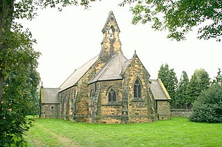
In 1221, the first reference is made to a church leader of "St Peter in Barnebi", during a dispute between the monks of Roche Abbey and Hugh, parson of the church in Barnby Dun, who had been accused of interfering with the right of the monks to collect tithes of grain in the village. The outcome of the dispute, adjudicated by the Abbot of Selby and two priors in York, was that the monks would continue to collect tithes in Barnby Dun as long as payment of eleven pounds of incense were made to the church annually, and that an adequate area of land was cultivated by the monks. [20]

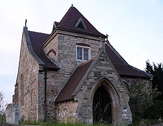
In 1244, the second recorded church leader - Benedict - can be found as rector of the church of St Peter and St Paul, Barneby. Later on in the 13th century, likely during the term of rector William de la Ryvere, the original wooden structure of the church was replaced by the beginnings of the present-day limestone building, though many additions and alterations have been made throughout the intervening centuries. [14]

During the 1221 dispute, one Hugh Folioth or Foliot is named, and it appears that throughout 13th century the Foliot family were landholders in Barnby Dun, including Richard Foliot who held one quarter of the village by 1292. [21] Some five years later, in 1297, the manor of Barnby Dun is referenced as being held by Richard de Barnby and his family [22] and other de Barnbys are referenced as potential lords in Barnby Dun around this time. [23] In 1347, the widow of Frank de Barnby - Idonia - leased the manor of Barnby-upon-Don to Piere de Marchelay for the remainder of his life. [24] Also in the 1340s, during the term of John de Barneby, the rectory of Barnby Dun was replaced by a vicarage. [25] It remains as such to the present day.

The Poll Tax of 1379 records 108 households in Barnby Dun, here referred to as Barmby super Done, and the tax collected from the village totalled 36 shillings and three pence. The village's vicar at the time, John Prest, can be seen on the tax as Johannes Presteson, and many other surnames display the agrarian nature of the village and of the time. [26] The church tower was constructed in 1450 during the vicariate of William Russel. [14]

On 27 October 1452 occurred the rape and abduction of Joan Beaumont in the village of Thorpe in Balne, which lies in the parish of Barnby Dun. Joan, the widow of Sir Henry Beaumont (1411-1447), [27] was abducted at high mass from the 12th-century chapel beside the manor house by a group of some forty men led by Edward Lancaster of Skipton - who raped, threatened and forcefully married her - and including John Paslewe [Pashley], [28] a resident of Barnby Dun proper. Beaumont's servants, John Cooke and John Louth, were also assaulted and 100 shillings were stolen from the Beaumont estate. [29] A petition was made to parliament in 1453 by Joan's son Henry and contracted husband Charles Nowell, Esq. which resulted in Lancaster's imprisonment and the reformation of marriage annulment laws to reduce the vulnerability of widowed women. [30]

Portington family (1480–1798)

In 1480, John Portington was born in Barnby Dun, the son of Thomas Portington who himself was son of Robert Portington, who both lived in the village but had originally hailed from Portington, East Riding of Yorkshire. [31] The 1480s mark the arrival of the Portington family, who would go on to become lords of the manor in Barnby Dun and be associated with the village for the best part of 300 years after their arrival.

By the end of the 16th century, the Portingtons had lived in Barnby Dun for over a century and had been involved in land disputes through the 16th century, [32] including the seizure of tithe payment to the parsonage in Hatfield in the 1530s. [33] In the 1530s and 40s, Lionel Portington and Thomas Hungate were involved in disputes over the manor of Barnby Dun [34] [35] and Hungate was leased part of the manor by Mary I in 1553. [36] A similar set of manors including Barnby Dun were in 1581 leased by Elizabeth I to Thomas Heneage. [37]

The manor of Barnby Dun by the late 16th century mostly belonged to the Blyth family. Throughout the 1580s and 90s, John Blyth, William Blyth and Anthony Blyth - who also owned part of the manor of Quarmby - were involved in a series of conveyances and indentures primarily including the Kaye family, [38] [39] William West, [40] [41] John Farrar, [42] Edward Bathecombe [42] and Roger Gregory [40] - of the prominent and ancient Gregory family [43] - which resulted in a complicated moiety comprising several lords.

Parish records at Barnby Dun's church of St Peter and St Paul began in 1599. [44]

Approach boldly, reader, whosoe’er thou art, if an honest man and one who follows the King, but if less than that depart, lest unknowingly, and by chance, thou shouldst press with thy heel these pious ashes, for Roger Portington’s bones lying beneath can ill bear a rebel’s foot. A man of ancient lineage and faithful to his chief illustrious, broken down by plunder and imprisonment, weary of years, as it were heavy with sleep, has gone to sleep, awaiting the morn of resurrection with Jane his wife, till the last trumpet shall sound.

17th-century memorial to Roger Portington,Church of St Peter and St Paul, Barnby Dun (translated from original Latin)

In 1637, Charles I granted - among other lands and tenements - free rents and tenancies in Barnby Dun to his third cousin The Earl of Lennox, [45] which may have pre-emptively evidenced a strong royalist sentiment on behalf of the most senior Portington and lord at the time, Roger Portington. Thus, at the outbreak of the English Civil War in the 1640s, Portington enlisted as a Lieutenant-Colonel and fought for his monarch but was taken prisoner for 16 years in Hull, [46] his commitment being remembered after his liberation in 1660 on a 17th-century memorial which remains to the present day in Barnby Dun's church. [47] [14] [43]

Seemingly as a result of his service to the royalist cause, by 1673 Portington - now in his seventh decade - was solely referred to as the lord of the manor of Barnby Dun. He died in late 1683 [48] and the manor passed to his eldest son, also named Roger. The Portingtons remained as lords of the manor until the death of his grandson, a fourth Roger Portington, on 13 May 1751. [29] The last remaining Portington in Barnby Dun was Ann Portington, sister of the final Roger Portington, who in November 1793 aged 73 was declared a lunatic. [49] She died in January 1798.

Arrival of industry (1730–2012)

After significant deliberation in the 1720s, the passage of the River Dun Navigation Acts in 1725 and 1726 and later disagreements in the early 1730s, [50] [51] [52] a cut was made for the construction of the River Dun Navigation canal, and a lock [50] and flood banks were constructed at Barnby Dun. [2]

In 1766, Thorpe Marsh and Grumble Hurst - both lands in the parish of Barnby Dun, though parts of Grumble Hurst lied in the parish of Arksey [53] - were enclosed. The enclosure award was granted two years later. Barnby Dun would itself later be enclosed in 1803, the award being granted in 1808. [54] [55]

On 10 July 1798, a 29-year-old James Bruce, fifth son of the 5th Earl of Elgin and former Member of Parliament for Marlborough, was drowned in the River Don while attempting to cross at Barnby Dun on horseback.

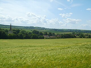
The following year, flooding was mentioned at the River Don in Barnby Dun. [56] In 1822, the population of the village was 495, excluding an additional population of 122 in Thorpe in Balne, of the same parish. There was also recorded one house in an area of the parish known as Reedholme, [57] which was ruined by 1849. [58] Reedholme and the ruins of Reedholme House are now part of Thorpe Marsh Nature Reserve.

By the early 1820s, plans were being produced for the construction of a railway which would pass through Barnby Dun. [59] [60] [61] The original South Yorkshire Railway opened in 1849, but did not pass through Barnby Dun until 1856 when a line along the River Dun Navigation was created between Doncaster and Thorne. [62] The line was opened on 7 July 1856, along with the first railway station in Barnby Dun.

In 1860, prominent landowner George Frederick Milnthorp - who also held part of the manor alongside Richard Heptonstall and one Mr. Ross in 1881 [43] - built the first of three malt kilns in the village, located near to the boundary with Kirk Sandall. This represented one of the first shifts in employment opportunity after the agricultural era for residents of Barnby Dun. [2]

The West Riding and Grimsby Railway opened in 1866, intersecting the north of Barnby Dun. [63] This railway line is now crossable in the parish at Applehurst Lane (private), [64] Thorpe Road, [65] Bramwith Road [66] and Stainforth Road. [67]

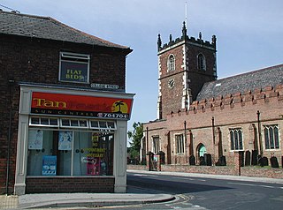
Although schools had been mentioned in Barnby Dun throughout the 19th century, the first official school opened in the village came in 1871 by the vicar of the time, John Duffin. The first headmaster was Charles Newbound. [68] Also in 1871, the population of the parish was recorded as 484. [2] Duffin, who had studied at St John's College, Cambridge, [43] became the longest serving church leader on record at St Peter and St Paul by 1890, and he died on 3 April 1906 at the age of 80, having served as vicar in Barnby Dun for 50 years. During his term, in 1887, the number of bells in the church were increased to six. [14]

Barnby Dun's methodist church records began in 1875. [69]

In 1909, a pipe organ was installed in the church by Norman & Beard, [14] which was given by George Frederick Milnthorp and Andrew Carnegie of Skibo Castle. It replaced an earlier 1862 organ by Samuel Meacock (1826-1903), given by John Henry Newsome, [70] who had also given to the church a stained glass window to the memory of his father, James Newsome, his mother and his elder brother. [43] Milnthorp died on 5 May 1923 aged 81 after having sold much of his land on the boundary with Kirk Sandall to Pilkington's Glass Works. [2]

Sandhurst was built on Station Road by Samuel Porter in 1910 [71] alongside significant sand and gravel workings in the area and near Park Hill around the same time. [72] [73] The Star Inn, originally located closer to the canal, [74] was rebuilt opposite Ramper Lane by architect Harry Armitage Hickson in the early 1920s. [75] [76]

The construction of Thorpe Marsh Power Station began in 1959 and the station opened in 1963, providing a new, significant opportunity for employment in Barnby Dun. [2] Four workmen were accidentally killed at Thorpe Marsh on 7 January 1973, [77] and a memorial stone was placed by the site of the power station. It has since been relocated to the church of St Peter and St Paul. [78]

It was announced on 8 June 1993 that Thorpe Marsh Power Station would be closing following the privatisation and dissolution of the Central Electricity Generating Board in 1991. The station closed in 1994 [79] and its six cooling towers were progressively demolished on 1 April, 10 June, 5 August and 19 August 2012. [80] No explosives were used to protect the River Don, and bulldozers were used instead. [81]

Recent history (1967–present)

On 4 September 1967, Barnby Dun railway station was closed and later demolished in July 2008. [82]

The Old Manor House at Barnby Dun was demolished in 1969 and its surrounding land replaced by a housing estate. [83] [84]

Thorpe Marsh Nature Reserve, on the ancient pasture and marshland site adjacent to Thorpe Marsh Power Station, was opened on 16 May 1980. [85] It is now managed by Yorkshire Wildlife Trust, [86] while the banks of Thorpe Marsh Drain are maintained by the Environment Agency. [87]

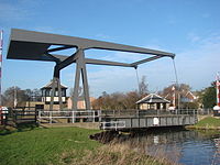
In 1982, the old wooden swing bridge across the River Dun Navigation canal connecting Madam Lane and Fordstead Lane was demolished and replaced by a new bascule bridge which remains to the present day. [88]

In 1994, Barnby Dun Old School closed and was replaced by Barnby Dun Primary Academy. The Old School was reopened in July 2005 as a community centre, and the site is leased to local businesses. [2]

Large housing developments were undertaken in the east of Barnby Dun in 2000, followed by further plans to develop housing on a 27.7-acre site north of Hatfield Lane in 2019. The construction of 166 houses were proposed by Stonebridge Homes, though such plans are yet to come to fruition. [89]

Transport

Boats are used on the canal and River Don. Barnby Dun railway station operated here until its closure. Kirk Sandall railway station still operates close by.

Education

Barnby Dun Primary School is here. Arksey School is in the neighbouring village of Arksey.

See also

Related Research Articles

<span class="mw-page-title-main">Hatfield, South Yorkshire</span> Town and civil parish in South Yorkshire, England

Hatfield is a town and civil parish in the City of Doncaster in South Yorkshire, England. It had a population of 17,236 at the 2011 Census. The town is located on the A18 road between Doncaster and Scunthorpe, and to the west of the M18 motorway. It shares a railway station with Stainforth on the line between Goole and Scunthorpe, and Doncaster. Recorded history in the parish extends as far back as 730, when Bede wrote about the Northumbrian King, Edwin, being killed in battle in the area.

<span class="mw-page-title-main">Doncaster Central (UK Parliament constituency)</span> Parliamentary constituency in the United Kingdom since 1983

Doncaster Central is a constituency represented in the House of Commons of the UK Parliament since 1997 by Dame Rosie Winterton of the Labour Party. Since 2017, Winterton has served as one of three Deputy Speakers of the House; she is the second MP for the constituency to be a Deputy Speaker, after Harold Walker.

<span class="mw-page-title-main">Skellow</span> Village in South Yorkshire, England

Skellow is a village in the Doncaster district, in the county of South Yorkshire, England. Historically part of the West Riding of Yorkshire, the village is roughly 5 miles (8 km) north-west of Doncaster. The village falls in the Askern Spa Ward of Doncaster MBC. To the north and south is mixed farmland, the A1 runs immediately along the western edge of the village, and to the east Skellow merges with the adjacent village of Carcroft along the B1220 road.

<span class="mw-page-title-main">Eastrington</span> Village and civil parish in the East Riding of Yorkshire, England

Eastrington is a small village and civil parish in the East Riding of Yorkshire, England. It is situated approximately 3 miles (5 km) to the east of Howden and 17 miles (27 km) south east of York.

<span class="mw-page-title-main">Whitley, North Yorkshire</span> Village in North Yorkshire, England

Whitley is a village in North Yorkshire, England, close to the Aire and Calder Navigation and the M62 motorway. The population of the village at the 2001 census was recorded as being 574, which had risen to 1,021 by the time of the 2011 census. In 2015, North Yorkshire County Council estimated the population to have risen again to 1,110. It was historically part of the West Riding of Yorkshire until 1974. From 1974 to April 2023 it was in the Selby District of North Yorkshire.

<span class="mw-page-title-main">Barnby Dun with Kirk Sandall</span> Civil parish in England

Barnby Dun with Kirk Sandall is a civil parish in the Metropolitan Borough of Doncaster in South Yorkshire, England. According to the 2001 census it had a population of 8,524 and by 2011 this had risen to 8,592. The parish covers Barnby Dun and Kirk Sandall, both parts of the Doncaster urban area.

<span class="mw-page-title-main">Strafforth and Tickhill</span> Former district in Yorkshire, England

Strafforth and Tickhill, originally known as Strafforth, was the southernmost wapentake in the West Riding of Yorkshire, England. The west of the district, plus a detached area in the east, constituted the Upper Division, while the central area and a detached part in the extreme east constituted the Lower Division.

The South Yorkshire Railway was a railway company with lines in the West Riding of Yorkshire, England.

<span class="mw-page-title-main">Bramwith railway station (West Riding and Grimsby Railway)</span> Disused railway station in South Yorkshire, England

Bramwith (WR&G) railway station, which was named Barnby Dun on opening, believed to be 1872, due to its close proximity to the village of that name, took the name Bramwith,, from the village of Kirk Bramwith, near Doncaster, South Yorkshire, England although it was over two miles away. This was possibly to avoid confusion with the station rebuilt on the Manchester, Sheffield and Lincolnshire Railway's straightened line between Doncaster and Thorne. The station was also closer to the village of Thorpe-in-Balne, to the north, than Kirk Bramwith. It was located at the level crossing near the junction of North Field Lane with Bramwith Lane, east of the River Don Navigation.

<span class="mw-page-title-main">Wintringham, North Yorkshire</span> Village and civil parish in North Yorkshire, England

Wintringham is a village and civil parish in North Yorkshire, England. The village is near the A64 road and 6 miles (9.7 km) east of Malton.

<span class="mw-page-title-main">Thorpe Marsh Power Station</span> Former coal-fired power station

Thorpe Marsh Power Station was a 1 GW coal-fired power station near Barnby Dun in South Yorkshire, England. The station was commissioned in 1963 and closed in 1994. In 2011, permission was given for the construction of a gas-fired power station on the site.

<span class="mw-page-title-main">Sandal Magna</span> Suburb in Wakefield, West Yorkshire, England

Sandal Magna or Sandal is a suburb of Wakefield, West Yorkshire, England with a population in 2001 of 5,432. An ancient settlement, it is the site of Sandal Castle and is mentioned in the Domesday Book. It is 2 mi (3.2 km) south from Wakefield, 8 mi (13 km) north of Barnsley. The Battle of Wakefield was fought here in the 15th century during the Wars of the Roses.

<span class="mw-page-title-main">Kirk Smeaton</span> Village and civil parish in North Yorkshire, England

Kirk Smeaton is a village and civil parish in North Yorkshire, England. It is located at the southern end of the county, close to South Yorkshire and East Riding of Yorkshire. Historically, the village was part of the West Riding of Yorkshire until 1974.

<span class="mw-page-title-main">Edenthorpe</span> Village and civil parish in South Yorkshire, England

Edenthorpe is a village and civil parish on the eastern edge of Doncaster, South Yorkshire, England. At the 2001 census, it had a population of 4,752, increasing slightly to 4,776 at the 2011 Census. The village lies 4 miles (6.4 km) to the north east of Doncaster city centre.

<span class="mw-page-title-main">Kirk Sandall</span> Village in South Yorkshire, England

Kirk Sandall is an outer suburb of Doncaster, located around 4 miles (6.4 km) north-east of the city centre, in the civil parish of Barnby Dun with Kirk Sandall, in the county of South Yorkshire, England.

<span class="mw-page-title-main">St Oswald's Church, Kirk Sandall</span> Church in South Yorkshire, England

St Oswald's Church is a redundant Anglican church in Kirk Sandall, near Doncaster, South Yorkshire, England. It is recorded in the National Heritage List for England as a designated Grade II* listed building, and is under the care of the Churches Conservation Trust.

<span class="mw-page-title-main">Sutton-on-Hull</span> Suburb of Kingston upon Hull, East Riding of Yorkshire, England

Sutton-on-Hull is a suburb of the city of Kingston upon Hull, in the ceremonial county of the East Riding of Yorkshire, England. It is located 3 miles (4.8 km) north east of the city centre and has the B1237 road running through it which connects the A165 road with the A1033.

Barnby Dun with Kirk Sandall is a civil parish in the metropolitan borough of Doncaster, South Yorkshire, England. The parish contains four listed buildings that are recorded in the National Heritage List for England. Of these, one is listed at Grade I, the highest of the three grades, one is at Grade II*, the middle grade, and the others are at Grade II, the lowest grade. The parish contains the villages of Barnby Dun and Kirk Sandall, and the surrounding area. The listed buildings consist of two churches, a churchyard cross, and a barn and cart shed.

<span class="mw-page-title-main">Thorpe Marsh Nature Reserve</span> Nature reserve in South Yorkshire, England

Thorpe Marsh Nature Reserve is a 77-hectare (190-acre) nature reserve located south-west of Thorpe in Balne, north of Doncaster in South Yorkshire, England. The reserve is managed and maintained by a team of volunteers under the Yorkshire Wildlife Trust as well as Doncaster Metropolitan Borough Council.

References

  1. The Domesday Book online. "Yorkshire: West Riding A-B" . Retrieved 2 January 2018.
  2. 1 2 3 4 5 6 7 "Barnby Dun History". www.barnbydunoldschool.co.uk. Retrieved 15 May 2024.
  3. Historic England. "Church of St Peter and St Paul (1151488)". National Heritage List for England . Retrieved 10 November 2021.
  4. "Distance from Barnby Dun [SE618094]". Genuki. Retrieved 2 January 2018.
  5. "Barnby Dun". City Population. Retrieved 2 January 2018.
  6. "Relationships and changes Barnby upon Don AP/CP through time". A Vision of Britain through Time. Retrieved 3 April 2023.
  7. "Population statistics Barnby upon Don AP/CP through time". A Vision of Britain through Time. Retrieved 3 April 2023.
  8. "British Geological Survey". www.bgs.ac.uk. BGS. Retrieved 21 August 2022.
  9. "LiDAR terrain map and aerial photograph of 53.574337, -1.081859 (SE 60895 09027), Barnby Dun Doncaster SE 61 09, , 53.574337,-1.081859, 53.57434, -1.08186 () ()". www.archiuk.com. Retrieved 30 May 2024.
  10. "The Lings, Barnby Dun, Doncaster. An Archaeological Evaluation". archaeologydataservice.ac.uk. Retrieved 30 May 2024.
  11. 1 2 Catalogue description Place name: Barnby Dun, Yorkshire Folio: 307v Great Domesday Book Domesday... 1086.
  12. 1 2 Catalogue description Place name: Barnby Dun, Yorkshire Folio: 321v Great Domesday Book Domesday... 1086.
  13. 1 2 Catalogue description Place name: Barnby Dun, Yorkshire Folio: 319v Great Domesday Book Domesday... 1086.
  14. 1 2 3 4 5 6 "Welcome to the Church of St Peter and St Paul, Barnby Dun". www.beakondoncaster.co.uk. Retrieved 29 May 2024.
  15. "Key to English Place-names". kepn.nottingham.ac.uk. Retrieved 29 May 2024.
  16. Mills, A. D. (1 January 2011), "Barnby", A Dictionary of British Place Names, Oxford University Press, doi:10.1093/acref/9780199609086.001.0001, ISBN   978-0-19-960908-6 , retrieved 29 May 2024
  17. Britain, Safer (5 December 2017). "Yorkshire's Robin Hood: The Barnsdale Secret : Robin Hood, the Forgotten Forest of Barnsdale and the Lost King of the North". Yorkshire's Robin Hood. Retrieved 30 May 2024.
  18. "Doncaster | Domesday Book". opendomesday.org. Retrieved 30 May 2024.
  19. "FamilySearch.org". ancestors.familysearch.org. Retrieved 30 May 2024.
  20. Award relating to tithes in Barnby. 1221.
  21. Catalogue description Debtor: Richard Foliot [who held one-quarter of Barnby Dun, Strafforth Wapentake, W.R.,... (in Latin). 14 July 1292.
  22. Catalogue description Debtor: Richard de Barnby {Bernaby} knight [family held Barnby Dun in Strafforth... (in Latin). 18 June 1297.
  23. Catalogue description Debtor: Thomas, son of Thomas [? lord] of Barnby Dun {super Done} [Strafforth Wapentake,... (in Latin). 13 July 2023.
  24. Confirmation by John Earl de Warenne of lease for life. 1347.
  25. "Genuki: Data from the 'Collectio Rerum Ecclesiasticarum' from the year 1842., Yorkshire (West Riding)". www.genuki.org.uk. Retrieved 30 May 2024.
  26. "Genuki: Subsidy Roll (Poll Tax) for 1379 for the Yorkshire parish of Barnby Dun, Yorkshire (West Riding)". www.genuki.org.uk. Retrieved 30 May 2024.
  27. Hebrew, Dr Wilton McDonald-black. "Henry de Beaumont (± 1411-± 1447) » M(a)cDonald Family Site - black Jewish YAHYA family line 3 » Genealogy Online". Genealogy Online. Retrieved 30 May 2024.
  28. "Pashley Surname Origin, Meaning & Last Name History". forebears.io. Retrieved 30 May 2024.
  29. 1 2 September 9, Roger Luffman |; Reply, 2012 at 7:46 pm | (3 September 2012). "James Fretwell's Diary – circa 1720". Doncaster History. Retrieved 30 May 2024.{{cite web}}: CS1 maint: numeric names: authors list (link)
  30. Catalogue description Petitioners: Henry Beaumont, knight; Charles Nowell, esquire; John Twycrosse, yeoman. ... 1453.
  31. www.familysearch.org https://www.familysearch.org/tree/person/details/9V5N-NC2 . Retrieved 30 May 2024.{{cite web}}: Missing or empty |title= (help)
  32. Catalogue description Robert Whitehed v John Portyngton: land in Barnby upon Don, Yorkshire. [Standard... 1517.
  33. Catalogue description Short title: Portyngton v Snydall. Plaintiffs: Thomas Portyngton of Hensam (i.e.,... 1533–1538.
  34. Catalogue description Short title: Portyngton v Hungate. Plaintiffs: Lionel, brother and heir of Thomas... 1544–1551.
  35. Catalogue description Short title: Hungayt v Partyngton. Plaintiffs: Thomas HUNGAYT, esquire, and Isabel his... 1538–1544.
  36. Catalogue description Lease, for 21 years, granted by Mary I to Thomas Hungate, esq, one of the four chief... 14 November 1553.
  37. Catalogue description Lease, for 57½ years, granted by Elizabeth I to Thomas Heneage, treasurer of her... (in Latin). 8 May 1581.
  38. Catalogue description Indenture whereby John Blythe, Elizabeth his wife, and William Blythe of Rotherham... 1587.
  39. Catalogue description Ante nuptial agreement between John Blyth of Quarmby and John Kaye of Wodsome. Thomas... 1575–1586.
  40. 1 2 Catalogue description Assignment by Thomas Cleyton to William, son of William West, and Roger Gregory of the... 1594–1601.
  41. Catalogue description Short title: West v Blyth. Plaintiffs: William West . Defendants: William Blyth and... 1591–1596.
  42. 1 2 Conveyance. 7 December 1591.
  43. 1 2 3 4 5 "Barnby upon Don Genealogy Resources & Parish Registers | West Riding". forebears.io. Retrieved 30 May 2024.
  44. Barnby Dun, St Peter and St Paul parish records. 1599–1979.
  45. Copy letters patent from King Charles I. 1637.
  46. "Civil War Petitions". www.civilwarpetitions.ac.uk. Retrieved 30 May 2024.
  47. [25307] St Peter & St Paul, Barnby Dun : Roger Portington, 20 June 2009, retrieved 30 May 2024
  48. www.familysearch.org https://www.familysearch.org/tree/person/details/KCFD-N5L . Retrieved 31 May 2024.{{cite web}}: Missing or empty |title= (help)
  49. Catalogue description Ann Portington, spinster of Barmby upon Dunn [Barnby Dun], Yorkshire: commission and... 14 November 1793.
  50. 1 2 COPY of proposals concerning the navigation upon the River Don, signed by Richd. Whitaker (Mayor) and Sam'l. Shore. 5 February 1731.
  51. Letter from Edward Simpson to Joseph Mellish. 15 March 1731.
  52. Letter from Edward Simpson to Joseph Mellish. 15 April 1731.
  53. "Genuki". www.genuki.org.uk. Retrieved 31 May 2024.
  54. Volume of Local Enclosure Acts. 1761–1828.
  55. Barnby Dun with Kirk Sandall parish council records. <corpname>Barnby Dun with Kirk Sandall parish council</corpname>. 1768–1959.{{cite book}}: CS1 maint: others (link)
  56. Letter to Bryan Cooke from G(eorge) Cooke at Wheatley. 17 April 1799.
  57. "Genuki: Barnby Dun, Yorkshire (West Riding)". www.genuki.org.uk. Retrieved 31 May 2024.
  58. "View map: Ordnance Survey, Yorkshire 277 (includes: Armthorpe; Barnby Dun with Kirk Sandall; Bentley with Arksey; Doncaster.) - Ordnance Survey Six-inch England and Wales, 1842-1952". maps.nls.uk. Retrieved 31 May 2024.
  59. (1) Plan of an intended railroad from Wentbridge to Barnby upon Dun and a branch there from Womersley to Kirk Smeaton all in the West Riding of the county of York, 1822; (2) Section... to Barnby upon Dun; (3) Section of the intended branch... to Kirk Smeaton. 30 September 1822.
  60. Correspondence addressed to M. Ellison about effect on Sheffield Collieries of proposed railways from Worsbro' Bridge to Oxspring, and Womersley to Barnby Dun. 1821–1822.
  61. Plan for a proposed rail road intended to be made from or near to Barnby upon Dun to the lime rocks at Womersley with a branch therefrom on the south side of the river Went at Norton Priory to the turnpike road at Wentbridge all in the West Riding of the county of York, 1821. 29 September 1821.
  62. Accounts and Papers of the House of Commons. Ordered to be printed. 1857.
  63. Lancashire & Yorkshire and Great Eastern Junction Railway. 1864.
  64. "Applehurst Lane Level Crossing - The ABC Railway Guide". abcrailwayguide.uk. Retrieved 31 May 2024.
  65. "Thorpe Road Level Crossing - The ABC Railway Guide". abcrailwayguide.uk. Retrieved 31 May 2024.
  66. "Bramwith Road Level Crossing - The ABC Railway Guide". abcrailwayguide.uk. Retrieved 31 May 2024.
  67. "Stainforth Road Level Crossing - The ABC Railway Guide". abcrailwayguide.uk. Retrieved 31 May 2024.
  68. "About Us". www.barnbydunoldschool.co.uk. Retrieved 31 May 2024.
  69. Barnby Dun Methodist Church records. <corpname>Barnby Dun Methodist Church</corpname>. 1875–1980.{{cite book}}: CS1 maint: others (link)
  70. "NPOR | The National Pipe Organ Register". npor.org.uk. Retrieved 31 May 2024.
  71. "Sandhurst, Station Road, Barnby Dun" (PDF). Robinson Hornsby. Retrieved 31 May 2024.
  72. Plan of Sand and Gravel Pits, Barnby Dun. Shows area and dates of working. Coloured. Plan No. 117 Scale 60' - 1". 8 September 1919.
  73. Articles of partnership between S. Porter and Son., Barnby Dun contractors and F. G. Foster, of Selby, surveyor. Sand and gravel workings. 14 August 1914.
  74. "View map: Ordnance Survey, Yorkshire CCLXXVII.3 (Barnby Dun With Kirk Sandall; Hatfield; Stainforth) - Ordnance Survey 25 inch England and Wales, 1841-1952". maps.nls.uk. Retrieved 31 May 2024.
  75. Records of H A Hickson of Doncaster, Architect. Hickson, H A, fl 1934 - 1936, architect of Doncaster. 1921–1940.{{cite book}}: CS1 maint: others (link)
  76. "Map Document View". www.oldmapsonline.org. Retrieved 31 May 2024.
  77. "Thorpe Marsh Power Station (Workmen's Deaths) (Hansard, 5 March 1973)". api.parliament.uk. Retrieved 31 May 2024.
  78. Bateman, Stephanie (23 March 2023). "Relocation of memorial stone marking the lives of those killed at Thorpe Marsh Power Station now in the grounds of Barnby Dun Church". Doncaster Free Press. Retrieved 31 May 2024.
  79. "Thorpe Marsh Power Station (Hansard, 16 June 1993)". api.parliament.uk. Retrieved 31 May 2024.
  80. "ABLE Thorpe Marsh | Able UK". 4 October 2014. Archived from the original on 4 October 2014. Retrieved 31 May 2024.
  81. "Thorpe Marsh Power Station Cooling Towers, Doncaster". www.theviewfromthenorth.org. Retrieved 31 May 2024.
  82. Catalogue description Proposed withdrawal of passenger services from Barnby Dun Station. 1967.
  83. http://sytimescapes.org.uk/files/u1/docs/D9b-Doncaster-Nucleated-Settlement-Gazeteerv3.pdf
  84. "Manor House From The West At Barnby Dun (OS60/F11/2) Archive Item - Ordnance Survey Collection | Historic England". historicengland.org.uk. Retrieved 31 May 2024.
  85. "Article - The History of Thorpe Marsh Power Station (by Dave Cook)". priorieshistoricalsociety.blogspot.com. Retrieved 31 May 2024.
  86. "Thorpe Marsh". www.ywt.org.uk. Retrieved 31 May 2024.
  87. "Thorpe Marsh Gas Pipeline Examining Authority's Report of Findings and Conclusions and Recommendation to the Secretary of State for Energy and Climate Change (p. 111; 8.6.15, 8.6.16)" (PDF). Infrastructure Planning Inspectorate. The Planning Inspectorate (Kelvin MacDonald). Archived (PDF) from the original on 30 July 2022. Retrieved 29 July 2022.
  88. Barnby Dun: photographs of the building of the Bascule Bridge 1982 and local personalities 1984-1992. Clark, Neil G, d 2001, of Barnby Dun. 1984–1992.{{cite book}}: CS1 maint: others (link)
  89. Farrell, Stephen (18 January 2024). "Housing plans submitted for South Yorkshire site". Insider Media Limited. Retrieved 31 May 2024.