West Yorkshire is a metropolitan and ceremonial county in the Yorkshire and the Humber region of England. It borders North Yorkshire to the north and east, South Yorkshire and Derbyshire to the south, Greater Manchester to the south-west, and Lancashire to the west. The city of Leeds is the largest settlement.

Doncaster is a city in South Yorkshire, England. Named after the River Don, it is the administrative centre of the City of Doncaster metropolitan borough, and is the second largest settlement in South Yorkshire after Sheffield. Noted for its horse racing and railway history, it is situated in the Don Valley on the western edge of the Humberhead Levels and east of the Pennines. The built up area had a population of 87,455 at the 2021 census, whilst the wider metropolitan borough had a population of 308,100.

The West Riding of Yorkshire is one of three historic subdivisions of Yorkshire, England. From 1889 to 1974 the riding was an administrative county named County of York, West Riding. The lieutenancy at that time included the city of York and as such was named "West Riding of the County of York and the County of the City of York". The riding ceased to be used for administrative purposes in 1974, when England's local government was reformed.
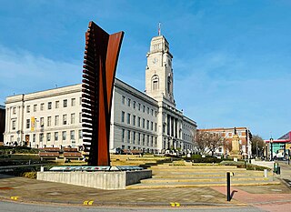
Barnsley is a market town in South Yorkshire, England. It is the main settlement of the Metropolitan Borough of Barnsley and the fourth largest settlement in South Yorkshire. The town's population was 96,888 in 2021, while the wider borough had a population of 244,600 in the 2021 census.

North East Derbyshire is a local government district in Derbyshire, England. The council is based in the large village of Wingerworth. The district also includes the towns of Dronfield and Clay Cross as well as numerous villages and surrounding rural areas.

The Metropolitan Borough of Rotherham is a metropolitan borough of South Yorkshire, England. It is named after its main settlement of Rotherham. The wider borough spans a larger area and covers the outlying towns of Maltby, Swinton, Wath-upon-Dearne, Dinnington. As well as the villages of Rawmarsh and Laughton. A large valley spans the entire borough and is referred to as the "Rother Valley".
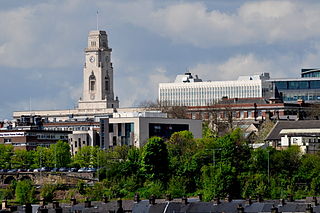
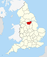
The Metropolitan Borough of Barnsley is a metropolitan borough in South Yorkshire, England; the main settlement is Barnsley and other notable towns include Penistone, Wombwell and Hoyland.

The Redcliffe-Maud Report was published in 1969 by the Royal Commission on Local Government in England, under the chairmanship of Lord Redcliffe-Maud. Although the commission's proposals were broadly accepted by the Labour government, they were set aside by the Conservative government elected in 1970.
Sheffield is a geographically diverse city in England. It nestles in the eastern foothills of the Pennines and the confluence of five rivers: Don, Sheaf, Rivelin, Loxley and Porter. As such, much of the city is built on hillsides, with views into the city centre or out to the countryside. The city is roughly one third urban, one third rural and one third in the Peak District. At its lowest point the city stands just 29 metres above sea level at Blackburn Meadows on the Rotherham border, rising up to over 500 m in some parts of the city to a peak of 548m at High Stones on the Derbyshire border; however, 89% of the housing in the city is between 100 and 200 metres above sea level. Over 95% of the population resides in the main urban area.
The Local Government Commission for England was established by the Local Government Act 1958 to review the organisation of local government, and make "such proposals as are hereinafter authorised for effecting changes appearing to the Commissions desirable in the interests of effective and convenient local government". Most of the commission's proposals failed to reach consensus and were not implemented, and the body was dissolved in 1967.

The A6195 road runs through the Dearne Valley in South Yorkshire, England.

Scouting in Yorkshire and the Humber is largely represented by the Scout Association of the United Kingdom and some Groups of traditional Scouting including the Baden-Powell Scouts' Association.

The South Yorkshire County Council (SYCC) — also known as South Yorkshire Metropolitan County Council — was the top-tier local government authority for the metropolitan county of South Yorkshire from 1 April 1974 to 31 March 1986. A strategic authority, with responsibilities for roads, public transport, planning, emergency services and waste disposal, it was composed of 100 directly elected members drawn from the four metropolitan boroughs of South Yorkshire: Barnsley, Doncaster, Rotherham and Sheffield.

The South Yorkshire Forest was a partnership initiative of the twelve Community Forests in England, started in 1991. The programme aimed to create attractive landscapes in the South Yorkshire area through improvement and regeneration of woodlands, wetlands, farmland, meadows, industrial sites and residential areas. Member organisations of the South Yorkshire Forest Partnership included the Forestry Commission, Natural England and the four local authorities of South Yorkshire: Sheffield City Council, Doncaster Metropolitan Borough Council, Barnsley Metropolitan Borough Council and Rotherham Metropolitan Borough Council.

The South Yorkshire Mayoral Combined Authority is the combined authority for South Yorkshire in England, with powers over transport, economic development and regeneration. It covers a total area of 3,484 km2 (1,345 sq mi) with a population of 1.8 million. The four metropolitan boroughs of South Yorkshire – Sheffield, Rotherham, Doncaster and Barnsley – are full members of the authority, while the Derbyshire Dales, North East Derbyshire, Chesterfield and Bolsover districts of Derbyshire, and the Bassetlaw district of Nottinghamshire, are non-constituent members.

The South and West Yorkshire Green Belt is an environmental and planning policy that regulates the rural space within the Yorkshire and the Humber region of England. The function of the green belt policy in South and West Yorkshire is to manage development around the cities, towns and villages in the West Yorkshire Urban Area, the Sheffield urban area, Barnsley and Doncaster, to discourage urban sprawl. It is managed by local planning authorities on guidance from central government.
This page includes the election results of the Yorkshire Party, a regional political party based in Yorkshire.

The Borough of Chesterfield is a non-metropolitan district with borough status in Derbyshire, England. It is named after the town of Chesterfield, its largest settlement, and also contains the town of Staveley and the large village of Brimington.