Barron Gorge National Park

Last updated

Barron Gorge National Park
Queensland
KurandaScenicRlyView2.JPG
Glacier Rock, 2009
Australia Queensland location map.svg
Red pog.svg
Barron Gorge National Park
Nearest town or city Cairns
Coordinates 16°50′34″S145°39′08″E / 16.84278°S 145.65222°E / -16.84278; 145.65222
Established1940
Area28 km2 (10.8 sq mi)
Managing authorities Queensland Parks and Wildlife Service
Website Barron Gorge National Park
See also Protected areas of Queensland

Barron Gorge National Park is a protected area in the Cairns Region, Queensland, Australia. It lies predominantly within the locality of Barron Gorge. [1] [2]

Contents

Geography

The park is 1,404 km northwest of Brisbane and 2 kilometres (1.2 mi) from Kuranda. Barron Gorge is part of the Wet Tropics World Heritage Area. [3] Skyrail Rainforest Cableway is a 7.5 kilometre scenic cableway running above the Barron Gorge National Park in the Wet Tropics of Queensland's World Heritage Area north of Cairns which has won more than 25 awards. The Kuranda Scenic Railway line passes through the park with a station at Barron Falls. [3] Two trains run from and return to Cairns daily. [4] The original weir, constructed in 1934 at the top of the falls, is visible from the station lookout and Skyrail's Barron Falls Station Archived 19 February 2017 at the Wayback Machine lookouts.

Landforms

View from the Skyrail Rainforest Cableway BARRON FALLS NATIONAL PARK.jpg
View from the Skyrail Rainforest Cableway
Barron Falls Barron falls january2005.JPG
Barron Falls

Barron Gorge formed where the Barron River passes over the eastern escarpment of the Atherton Tablelands. [5] Barron Falls cascade 265 m to the gorge below. Two waterfalls—Stoney Creek Falls and Surprise Creek Falls—exist on tributaries of the Barron River within the park. Slopes around the gorge are steep with some at a 45° angle. This made construction of the railway hazardous. 23 people died during its construction. [5]

History

In 1885, the explorer Archibald Meston described the Barron Falls in flood where the raging waters "rush together like wild horses as they enter the straight in the dread finish of their last race ... (where) the currents of air created by the cataract waved the branches of the trees hundreds of feet overhead ... the rock shook like a mighty steamer tumbling with the vibrations of the screw."

In 1935, the waters of the Barron River were harnessed in the Barron Gorge Hydroelectric Power Station to generate Queensland's first hydroelectric power. Two hundred metres from the base of the Barron Falls an underground power station was carved into the cliff face. Water was delivered through pipes to drive the turbines, two 1,200 kW turbo-alternators. The substation, workshops and staff houses were built around the area now forming the Skyrail station.

The Djabugandji Bama (Aboriginal people) are the traditional owners of the area known as Djirri Nyundu Nyrrumba, which includes Barron Gorge National Park. Ownership of the park returned to its traditional owners on 17 December 2004. [6] This is the first park in Queensland to have a native title determination. [7] Visitors to the park have not faced any changes under the new owners but Aboriginals were then able to hold traditional religious ceremonies.

Flora and fauna

Bird's-nest fern and elkhorn ferns grow amongst Candlenut, Corkwood, Native olive and False Red Sandalwood trees at the bottom of the gorge. [5]

The park forms part of the Wooroonooran Important Bird Area, identified as such by BirdLife International because it supports populations of a range of bird species endemic to Queensland's Wet Tropics. [8] Noisy pittas and the orange-footed scrubfowl are two species of bird that may be commonly seen. The southern cassowary is occasionally spotted in the southern section of the park. [5] Nocturnal animals are relatively common. These include a variety of possums and flying foxes as well as Lumholtz's tree-kangaroo and the northern quoll. [5]

See also

Related Research Articles

<span class="mw-page-title-main">Tully Gorge National Park</span> Protected area in Queensland, Australia

Tully Gorge is a national park in Queensland, Australia, 1,338 km northwest of Brisbane. The park forms part of the Wooroonooran Important Bird Area, identified as such by BirdLife International because it supports populations of a range of bird species endemic to Queensland's Wet Tropics.

<span class="mw-page-title-main">Wooroonooran National Park</span> Protected area in Queensland, Australia

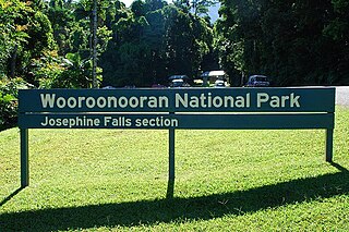
Wooroonooran National Park is a national park in Queensland, Australia, 1,367 km northwest of Brisbane, between Innisfail and Cairns.

<span class="mw-page-title-main">Mount Bartle Frere</span> Mountain in Queensland, Australia

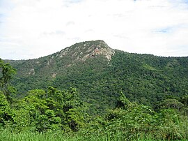
Mount Bartle Frere is the highest mountain in Queensland at an elevation of 1,611 metres (5,285 ft). The mountain was named after Sir Henry Bartle Frere, a British colonial administrator and then president of the Royal Geographical Society by George Elphinstone Dalrymple in 1873. Bartle Frere was British Governor of Cape Colony at the outset of the Anglo-Zulu War.

<span class="mw-page-title-main">Wet Tropics of Queensland</span> Natural world heritage site in Queensland, Australia

The Wet Tropics of Queensland World Heritage Site consists of approximately 8,940 km2 of Australian wet tropical forests growing along the north-east Queensland portion of the Great Dividing Range. The Wet Tropics of Queensland meets all four of the criteria for natural heritage for selection as a World Heritage Site. World Heritage status was declared in 1988, and on 21 May 2007 the Wet Tropics were added to the Australian National Heritage List.

<span class="mw-page-title-main">Kuranda, Queensland</span> Town in Queensland, Australia

Kuranda is a rural town and locality on the Atherton Tableland in the Shire of Mareeba, Queensland, Australia. In the 2016 census, Kuranda had a population of 3,008 people. It is 25 kilometres (16 mi) from Cairns, via the Kuranda Range road. It is surrounded by tropical rainforest and adjacent to the Wet Tropics of Queensland World Heritage listed Barron Gorge National Park.

<span class="mw-page-title-main">Skyrail Rainforest Cableway</span>

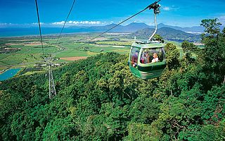
Skyrail Rainforest Cableway is a 7.5-kilometre (4.7 mi) scenic tourist cableway running above the Barron Gorge National Park, in the Wet Tropics of Queensland’s World Heritage Area in Australia. It operates from the Smithfield terminal in Cairns to the Kuranda terminal on the Atherton Tableland. It has won more than 25 awards.

The Barron Gorge Hydroelectric Power Station in Queensland, Australia is an electricity power station commissioned in 1963 with a maximum capacity of 66 megawatts (89,000 hp). It is in the locality of Barron Gorge in the Wet Tropics World Heritage Area 20 kilometres (12 mi) north-west of Cairns. It replaced an earlier station which was the first underground power station in the country and the first hydroelectric station in Queensland. The power station was refurbished in 2006.

<span class="mw-page-title-main">Barron Falls</span> Waterfall in Queensland, Australia

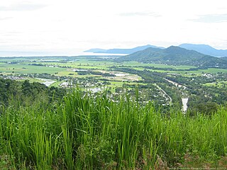
Barron Falls is a steep tiered cascade waterfall in Kuranda, Shire of Mareeba, Queensland, Australia. The falls are created by the Barron River descending from the Atherton Tablelands to the Cairns coastal plain.

<span class="mw-page-title-main">Djabugay</span> Australian Aboriginal people

The Djabugay people are a group of Australian Aboriginal people who are the original inhabitants of mountains, gorges, lands and waters of a richly forested part of the Great Dividing Range including the Barron Gorge and surrounding areas within the Wet Tropics of Queensland.

<span class="mw-page-title-main">Kuranda Scenic Railway</span>

The Kuranda Scenic Railway is a tourist railway service that operates along the heritage-listed Cairns-to-Kuranda railway line. Constructed in 1891, the line runs from Cairns, Queensland, over the Great Dividing Range to the town of Kuranda on the Atherton Tableland. Along the way, the route passes through the Macalister Range, as well as the suburbs of Stratford, Freshwater and Redlynch. Along the way, the train also stops at a lookout, which provides views of Barron Falls.

<span class="mw-page-title-main">Smithfield, Queensland</span> Suburb of Cairns, Queensland, Australia

Smithfield is a suburb of Cairns in the Cairns Region, Queensland, Australia. In the 2021 census Smithfield had a population of 6,664 people.

<span class="mw-page-title-main">Surprise Creek Falls</span> Waterfall in Far North Queensland, Australia

The Surprise Creek Falls, a segmented waterfall on the Surprise Creek, is located in the UNESCO World Heritage–listed Wet Tropics in the Far North region of Queensland, Australia.

<span class="mw-page-title-main">Bellenden Ker Range</span>

The Bellenden Ker Range, also known as the Wooroonooran Range is a coastal mountain range in Far North Queensland, Australia. Part of the Great Dividing Range it is located between Gordonvale and Babinda.

<span class="mw-page-title-main">Caravonica, Queensland</span> Suburb of Cairns, Queensland, Australia

Caravonica is a suburb of Cairns in the Cairns Region, Queensland, Australia. In the 2016 census, Caravonica had a population of 1,989 people.

<span class="mw-page-title-main">Wooroonooran Important Bird Area</span>

The Wooroonooran Important Bird Area comprises some 5125 km2 of mainly forested land in the Wet Tropics of Queensland World Heritage Site, of Far North Queensland, Australia.

<span class="mw-page-title-main">Kuranda National Park</span> Protected area in Queensland, Australia

Kuranda National Park is a national park in Far North Queensland, Australia. Like many national parks in the area it belongs to the Wet Tropics World Heritage Area. The park protects an important wildlife corridor in which rainforest and open eucalypt forest predominate. Walking, mountain biking and four-wheel driving are popular recreational activities.

<span class="mw-page-title-main">Cairns-to-Kuranda railway line</span> Railway line in Queensland, Australia

The Cairns-to-Kuranda Railway is a heritage-listed railway line from the Cairns Region to the Shire of Mareeba, both in Queensland, Australia. It commences at Redlynch, a suburb of Cairns and travels up the Great Dividing Range to Kuranda within the Shire of Mareeba on the Atherton Tableland. It was built from 1913 to 1915 by Queensland Railways. Components of it include Stoney Creek Bridge, the Rail Bridge over Christmas Creek, Kuranda railway station, and Surprise Creek Rail Bridge. It was added to the Queensland Heritage Register on 21 August 1992. The railway is used to operate a tourist rail service, the Kuranda Scenic Railway. It forms part of the Tablelands railway line.

<span class="mw-page-title-main">Barron Gorge, Queensland</span> Suburb of Cairns Region, Queensland, Australia

Barron Gorge is a rural locality in the Cairns Region, Queensland, Australia. In the 2016 census Barron Gorge had a population of 0 people.

<span class="mw-page-title-main">Macalister Range, Queensland</span> Suburb of Cairns Region, Queensland, Australia

Macalister Range is a coastal locality in the Cairns Region, Queensland, Australia. In the 2021 census, Macalister Range had a population of 0 people.

<span class="mw-page-title-main">Kuranda Fig Tree Avenue</span> Historic site in Queensland, Australia

Kuranda Fig Tree Avenue is a heritage-listed avenue of trees at Coondoo Street, Kuranda, Shire of Mareeba, Queensland, Australia. It was built in 1931. It is also known as Avenue of Ficus Microcarpa and Ficus Obliqua trees. It was added to the Queensland Heritage Register on 27 July 2018.

References

  1. "Barron Gorge National Park – Cairns Region (entry 1762)". Queensland Place Names. Queensland Government . Retrieved 24 June 2017.
  2. "Queensland Globe". State of Queensland . Retrieved 4 March 2018.
  3. 1 2 "Barron Gorge National Park". Department of National Parks, Recreation, Sport and Racing. 8 October 2013. Archived from the original on 4 August 2014. Retrieved 6 September 2014.
  4. "Kuranda Scenic Railway – The Tour". Queensland Rail. Archived from the original on 31 March 2009. Retrieved 8 May 2009.
  5. 1 2 3 4 5 Shilton, Peter (2005). Natural areas of Queensland. Mount Gravatt, Queensland: Goldpress. pp. 45–47. ISBN   0-9758275-0-2.
  6. Jeff Waters (17 December 2004). "National park to be handed back to traditional owners" (transcript). AM. Australian Broadcasting Corporation. Archived from the original on 10 November 2012. Retrieved 23 October 2009.
  7. "Nature, culture and history". Department of Environment and Science Queensland. Queensland Government. 8 September 2006. Archived from the original on 5 May 2019. Retrieved 20 May 2019.
  8. BirdLife International. (2011). Important Bird Areas factsheet: Wooroonooran. Downloaded from "BirdLife International - conserving the world's birds". Archived from the original on 30 June 2007. Retrieved 2012-12-09. on 2 December 2011.