Whitsunday Islands National Park

Last updated

Whitsunday Islands National Park
Queensland
IUCN category II (national park)

Whitsunday islands.jpg

Whitehaven beach on Whitsunday Island
Australia Queensland location map.svg
Red pog.svg
Whitsunday Islands National Park
Coordinates 20°3′37″S148°52′27″E / 20.06028°S 148.87417°E / -20.06028; 148.87417 Coordinates: 20°3′37″S148°52′27″E / 20.06028°S 148.87417°E / -20.06028; 148.87417
Established 1944
Area 170 km2 (65.6 sq mi)
Managing authorities Queensland Parks and Wildlife Service
Website Whitsunday Islands National Park
See also Protected areas of Queensland

Whitsunday Islands is a national park in Queensland, Australia, 920 kilometres (570 mi) northwest of Brisbane. It contains Whitsunday Island and 31 others. [1]

National park park used for conservation purposes of animal life and plants

A national park is a park in use for conservation purposes. Often it is a reserve of natural, semi-natural, or developed land that a sovereign state declares or owns. Although individual nations designate their own national parks differently, there is a common idea: the conservation of 'wild nature' for posterity and as a symbol of national pride. An international organization, the International Union for Conservation of Nature (IUCN), and its World Commission on Protected Areas (WCPA), has defined "National Park" as its Category II type of protected areas.

Queensland North-east state of Australia

Queensland is the second-largest and third-most populous state in the Commonwealth of Australia. Situated in the north-east of the country, it is bordered by the Northern Territory, South Australia and New South Wales to the west, south-west and south respectively. To the east, Queensland is bordered by the Coral Sea and Pacific Ocean. To its north is the Torres Strait, with Papua New Guinea located less than 200 km across it from the mainland. The state is the world's sixth-largest sub-national entity, with an area of 1,852,642 square kilometres (715,309 sq mi).

Brisbane capital city of Queensland, Australia

Brisbane is the capital of and the most populated city in the Australian state of Queensland, and the third most populous city in Australia. Brisbane's metropolitan area has a population of approximately 2.5 million, and the South East Queensland metropolitan region, centred on Brisbane, encompasses a population of more than 3.6 million. The Brisbane central business district stands on the historic European settlement and is situated inside a peninsula of the Brisbane River, about 15 kilometres from its mouth at Moreton Bay. The metropolitan area extends in all directions along the floodplain of the Brisbane River Valley between Moreton Bay and the Great Dividing Range, sprawling across several of Australia's most populous local government areas (LGAs)—most centrally the City of Brisbane, which is by far the most populous LGA in the nation. The demonym of Brisbane is "Brisbanite" or "Brisbanian".

Contents

Geography

Hill Inlet, 2009 Whitsunday Islands National Park (23979794372).jpg
Hill Inlet, 2009

The Whitsunday Islands lie midway along Australia's Queensland coast and are bordered by the Great Barrier Reef and the waters of the Coral Sea. Migrating humpback whales favour the waters around the Whitsunday Islands as a calving ground between May and September each year. [2] Marine stingers are found in the waters of the islands between October and May. [2]

Whitsunday Islands island group

The Whitsunday Islands are a collection of continental islands of various sizes off the central coast of Queensland, Australia, approximately 900 kilometres north of Brisbane. The northernmost of the islands are situated off the coast by the town of Bowen while the southernmost islands are off the coast by Proserpine. The island group is centered on Whitsunday Island, while the group's commercial center is Hamilton Island. The traditional owners of the area are the Ngaro people and the Gia people whose Juru Clan has the only legally recognized native title in the region.

Great Barrier Reef Coral reef system off the east coast of Australia, World Heritage Site

The Great Barrier Reef is the world's largest coral reef system composed of over 2,900 individual reefs and 900 islands stretching for over 2,300 kilometres (1,400 mi) over an area of approximately 344,400 square kilometres (133,000 sq mi). The reef is located in the Coral Sea, off the coast of Queensland, Australia. The Great Barrier Reef can be seen from outer space and is the world's biggest single structure made by living organisms. This reef structure is composed of and built by billions of tiny organisms, known as coral polyps. It supports a wide diversity of life and was selected as a World Heritage Site in 1981. CNN labelled it one of the seven natural wonders of the world. The Queensland National Trust named it a state icon of Queensland.

Coral Sea A marginal sea of the South Pacific off the northeast coast of Australia

The Coral Sea is a marginal sea of the South Pacific off the northeast coast of Australia, and classified as an interim Australian bioregion. The Coral Sea extends 2,000 kilometres (1,200 mi) down the Australian northeast coast.

The region spans from the beaches of Bowen in the north and Laguna Whitsundays in the south. All 74 of the islands are surrounded by the Great Barrier Reef and only eight of them are inhabited.

Bowen, Queensland Town in Queensland, Australia

Bowen is a coastal town and locality in the Whitsunday Region on the eastern coast of Queensland, Australia. The town of Merinda and the Abbot Point coal shipping port are also within the locality of Bowen. At the 2016 census, Bowen had a population of 10,377.

On Whitsunday Island is the six km long Whitehaven Beach. [3] The beach has camping and picnic facilities in its foredunes. A walking track links to Chance Bay.

Whitehaven Beach

Whitehaven Beach is a 7 km stretch along Whitsunday Island, Australia. The island is accessible by boat, seaplane & helicopter from Airlie Beach, as well as Hamilton Island. It lies across from Stockyard Beach, better known as Chalkie's Beach, on Haslewood Island. The beach is known for its crystal white silica sands and turquoise coloured waters. The beach has barbeque and camping facilities.

Access

Access is by private or commercial boat from Airlie Beach or Shute Harbour. [1]

Airlie Beach, Queensland Town in Queensland, Australia

Airlie Beach is a coastal locality in the Whitsunday Region of Queensland, Australia. In the 2016 census, Airlie Beach had a population of 1,208 people.

See also

Queensland is the second largest state in Australia. It contains 472 separate protected areas with a total land area of 69,388 km2 (26,791 sq mi). 223 of these are National parks, which is the highest number of any Australian state or territory, totalling 65,871 km2 (25,433 sq mi). Seven others are Scientific National Parks, totalling 522 km2 (202 sq mi).

Related Research Articles

Great Barrier Reef Marine Park Protected area in Queensland, Australia

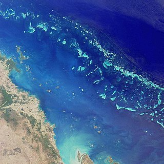
The Great Barrier Reef Marine Park protects a large part of Australia's Great Barrier Reef from damaging activities. It is a vast multiple-use Marine Park which supports a wide range of uses, including commercial marine tourism, fishing, ports and shipping, recreation, scientific research and Indigenous traditional use. Fishing and the removal of artefacts or wildlife is strictly regulated, and commercial shipping traffic must stick to certain specific defined shipping routes that avoid the most sensitive areas of the park. The Great Barrier Reef is the largest and best known coral reef ecosystem in the world. Its reefs, almost 3000 in total, represent about 10 per cent of all the coral reef areas in the world. It supports an amazing variety of biodiversity, providing a home to thousands of coral and other invertebrate species, bony fish, sharks, rays, marine mammals, marine turtles, sea snakes, as well as algae and other marine plants.

Brampton Islands National Park Protected area in Queensland, Australia

Brampton Islands is a national park in the Mackay Region, Queensland, Australia, 834 kilometres (518 mi) northwest of Brisbane. The park covers much of Brampton Island and all of Carlisle Island.

Green Island National Park Protected area in Queensland, Australia

Green Island National Park is a protected area declared over a small coral cay of Green Island, Cairns Region, Queensland, Australia. It is known to the local Gungganyji Aboriginal peoples as Dabuukji. The Gungganyji people used the island as an initiation ground.

Lizard Island Protected area in Queensland, Australia

Lizard Island is an island on the Great Barrier Reef in Queensland (Australia), 1624 km northwest of Brisbane and part of the Lizard Island Group that also includes Palfrey Island. It is part of the Lizard Island National Park. Lizard Island is within Cook Shire.

South Cumberland Islands National Park Protected area in Queensland, Australia

South Cumberland Islands is a national park in Queensland, Australia, 831 km northwest of Brisbane. It is famous for the Marine stingers which can be found in the waters of the park between October and May.

Hinchinbrook Island island in Australia

Hinchinbrook Island lies east of Cardwell and north of Lucinda, separated from the northern coast of Queensland, Australia by the narrow Hinchinbrook Channel. Hinchinbrook Island is part of the Great Barrier Reef Marine Park and wholly protected within the Hinchinbrook Island National Park, except for a small and abandoned resort. It is the largest island on the Great Barrier Reef. It is also the largest island national park in Australia.

Great Keppel Island Town in Queensland, Australia

Great Keppel Island lies 15 kilometres (9.3 mi) from the coast off Yeppoon in the Shire of Livingstone, Queensland, Australia. It is part of the Capricorn Coast of Central Queensland. The island is the largest of the eighteen islands in the Keppel Group, and covers an area of 1308 hectares. It is within the local government area of Shire of Livingstone.

Great Barrier Reef Airport airport

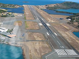
Great Barrier Reef Airport or Hamilton Island Airport is a privately owned public use aerodrome and is the primary airport of the Whitsunday Islands Group, and the airport of Hamilton Island. The airport is settled on mostly reclaimed land and due the island's tourism status, is occupied mostly and favoured by Australia's leading low-cost airline Jetstar Airways, as well as Virgin Australia and Qantas. Hamilton Island Airport handles direct flights from Sydney, Melbourne, Brisbane and Cairns and is also the airport launch pad for scenic flights to the Great Barrier Reef and Whitehaven Beach. Private flights and charters also fly into Great Barrier Reef Airport, along with locally operated helicopters, light planes and seaplanes.

Air Whitsunday Australian charter airline

Air Whitsunday is a charter airline based in Australia that operates a fleet of seaplanes. The company also operates tours.

Geography of Queensland

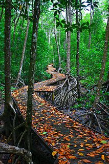
The geography of Queensland in the north-east of Australia, is varied. It includes tropical islands, sandy beaches, flat river plains that flood after monsoon rains, tracts of rough, elevated terrain, dry deserts, rich agricultural belts and densely populated urban areas.

The Ngaro were a seafaring Australian Aborigine group of people that inhabited the Whitsunday Islands and coastal regions of Queensland, in an area that archaeologically shows evidence of human habitation since 9000 BP. Ngaro society was destroyed by warfare with traders, colonists, and the Australian Native Police. The Native Police Corps forcibly relocated the remaining Ngaro aborigines in 1870 to a penal colony on Palm Island or to the lumber mills of Brampton Island as forced laborers.

Great Palm Island, also known as Palm Island, or by the Aboriginal name Bwgcolman; is a tropical island with a resident community of about 2,000 people. The island has an area of 55 km2 (21 sq mi). The official area figure of 70.9 km² refers to Aboriginal Shire of Palm Island and includes nine smaller islands. It is in Queensland, Australia, off the east coast of northern Queensland, situated 65 kilometres (40 mi) northwest of Townsville, and 800 kilometres (500 mi) north of the Tropic of Capricorn. The Australia Post lists the local post office as Palm Island, QLD. It is the main island of the Greater Palm group, and consists of small bays, sandy beaches and steep forested mountains rising to a peak of 548 metres (1,798 ft). The ocean surrounding the island is part of the Great Barrier Reef Marine Park where extraction and fishing are regulated.

Hamilton Island (Queensland) island

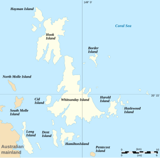
Hamilton Island is the largest inhabited island of the Whitsunday Islands in Queensland, Australia. It is positioned approximately 887 kilometres (551 mi) north of Brisbane and 512 kilometres (318 mi) south of Cairns. It is also the only island in the Great Barrier Reef with its own commercial airport, with short direct flights from Sydney, Melbourne, Brisbane and Cairns. Like most in the Whitsunday group, Hamilton Island was formed as sea levels rose which created numerous drowned mountains that are situated close to the east coast of Queensland. At the 2011 Australian Census, the island recorded a population of 1,208 people. Hamilton Island is a popular tourist destination all year round. In late August, the island plays host to its annual Hamilton Island Race Week yachting festival, in which more than 250 yachts from across Australia and New Zealand gather for a week of races around the Whitsunday Islands. This is only one of many events hosted on the island. Hamilton Island has won multiple awards including the Australian Traveller 'Most Desirable Island Escape' Award in 2015.

Chalkies Beach

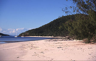
Chalkie's Beach is located on the western coast of Haslewood Island in the Whitsunday Islands of Queensland, Australia. It lies across from the more popular Whitehaven Beach on the main Whitsunday Island.

References

  1. 1 2 "About Whitsunday Islands". Department of National Parks, Sport and Racing. 1 December 2014. Retrieved 7 March 2016.
  2. 1 2 Explore Queensland's National Parks. Prahran, Victoria: Explore Australia Publishing. 2008. p. 19. ISBN   978-1-74117-245-4.
  3. Short, Andrew D.; Brad Farmer (2012). 101 Best Australian Beaches. NewSouth. p. 208. ISBN   1742245994 . Retrieved 7 March 2016.

Commons-logo.svg Media related to Whitsunday Islands National Park at Wikimedia Commons