Whitsunday Region

Last updated

Whitsunday Region
Queensland
Whitsunday LGA Qld 2008.png
Location within Queensland
ProserpineAerialAug2017.jpg
Aerial view of Proserpine, the service & administrative centre and ultimately gateway to the region by road, rail and air
Population35,050 (2018) [1]
 • Density1.47151/km2 (3.8112/sq mi)
Established2008
Area23,819 km2 (9,196.6 sq mi) [1]
MayorJulie Hall (One Nation) [2]
Council seat Proserpine
Region North Queensland
State electorate(s)
Federal division(s)
Whitsunday regional council logo.svg
Website Whitsunday Region
LGAs around Whitsunday Region:
Burdekin Coral Sea Coral Sea
Charters Towers Whitsunday Region Coral Sea
Isaac Isaac Mackay

The Whitsunday Region is a local government area located in North Queensland, Australia. Established in 2008, it was preceded by two previous local government areas with a history extending back to the establishment of regional local government in Queensland in 1879.

Contents

It has an estimated operating budget of A$48.8m.

History

Prior to 2008, the new Whitsunday Region was an entire area of two previous and distinct local government areas:

The Bowen Municipality was constituted on 7 August 1863 under the Municipalities Act 1858 (a piece of New South Wales legislation inherited by Queensland at its separation four years earlier). On 11 November 1879, the Wangaratta Division was created as one of 74 divisions around Queensland under the Divisional Boards Act 1879. With the passage of the Local Authorities Act 1902, Wangaratta became a shire and Bowen became a town on 31 March 1903.

On 19 January 1910, the Shire of Proserpine was excised from Wangaratta. It was renamed on 18 February 1989.

On 2 April 1960, the Town of Bowen was abolished, and merged into the Shire of Wangaratta, which was renamed Bowen. [3]

In July 2007, the Local Government Reform Commission released its report and recommended that the two areas amalgamate. [4] Both councils and residents across the board opposed amalgamation, although amalgamation with each other was the preferred option of each if forced to choose. On 15 March 2008, the Shires formally ceased to exist, and elections were held on the same day to elect councillors and a mayor to the Regional Council.

In 2012, a petition signed by over 1600 people requested that the Whitsunday Region be de-amalgamated. Although the number of signatories was sufficiently large, the Queensland Government refused the request for a de-amalgamation vote arguing that the financial modelling did not show that deamalgamation would be financially viable. [5]

In March 2017, many areas of the Whitsunday Region were damaged by Cyclone Debbie. The Proserpine Council Chambers was extensively damaged. [6]

Cyclone Debbie recovery

A new $6 million council administration building will be constructed in Proserpine during late 2018/2019, after this facility is completed workers that are temporarily being housed in Cannonvale will re-locate back to Proserpine. This will be a major new building that will also include a new disaster hub and resilience center. [7]

Wards

The council is split into six divisions, each returning one councillor, plus a mayor.

Towns and localities

The Whitsunday Region includes the following settlements:

Libraries

The Whitsunday Regional Council operate public libraries at Bowen, Cannonvale, Collinsville, and Proserpine. [8]

Population

Proserpine, a major population centre in the Whitsunday Region, home to the region's hospital, railway station, airport and a variety of educational facilities from early education up to secondary school. Proserpine Skyline Panorama.jpg
Proserpine, a major population centre in the Whitsunday Region, home to the region's hospital, railway station, airport and a variety of educational facilities from early education up to secondary school.
YearPopulation
(Total)
Population
(Bowen)
Population
(Whitsunday)
193311,4777,5433,934
194711,7008,0833,617
195413,0948,5184,576
196114,6049,4915,113
196615,6169,3426,274
197116,65110,2316,420
197619,03811,2927,746
198124,47813,64510,833
198625,94514,36411,581
199129,38814,16115,227
199631,20214,41116,791
200132,02113,69818,323
200636,15814,62521,533
201633,778
202137,152

List of mayors

#NamePartyYears in office
1 Mike Brunker [9] Labor 2008–2012
2Jennifer Whitney [10] Independent 2012–2016
3 Andrew Willcox [11] [12] Liberal National 2016–2022
4Julie Hall [13] One Nation 2022–present

See also

Related Research Articles

<span class="mw-page-title-main">Airlie Beach, Queensland</span> Suburb of Whitsunday Region, Queensland, Australia

Airlie Beach is a coastal locality and resort town in the Whitsunday Region of Queensland, Australia. In the 2016 census, Airlie Beach had a population of 1,208 people.

<span class="mw-page-title-main">Shute Harbour</span> Suburb of Whitsunday Region, Queensland, Australia

Shute Harbour is a coastal locality and harbour in the Whitsunday Region of Queensland, Australia. It has port facilities and transport options for people seeking to access the Whitsunday Islands and holiday destinations.

<span class="mw-page-title-main">Proserpine, Queensland</span> Town in Queensland, Australia

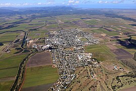
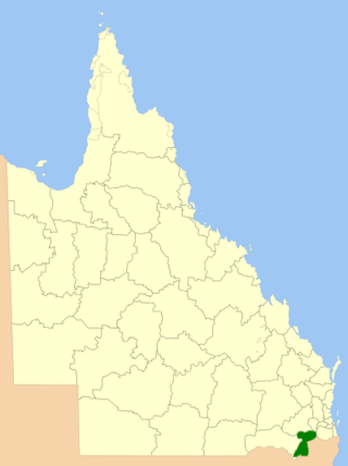
Proserpine is a rural town and locality in the Whitsunday Region, Queensland, Australia. In the 2021 census, the locality of Proserpine had a population of 3,614 people.

<span class="mw-page-title-main">Shire of Bowen</span> Local government area in Queensland, Australia

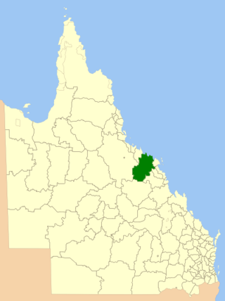
The Shire of Bowen was a local government area in the North Queensland region of Queensland, Australia. The shire, administered from the town of Bowen, covered an area of 21,184.4 square kilometres (8,179.3 sq mi), and existed as a local government entity from 1879 until 2008, when it amalgamated with the Shire of Whitsunday to form the Whitsunday Region.

<span class="mw-page-title-main">Shire of Whitsunday</span> Local government area in Queensland, Australia

The Shire of Whitsunday was a local government area located in the North Queensland region of Queensland, Australia. The shire, administered from the town of Proserpine, covered an area of 2,678.3 square kilometres (1,034.1 sq mi), and existed as a local government entity from 1910 until 2008, when it amalgamated with the Shire of Bowen to form the Whitsunday Region.

<span class="mw-page-title-main">Shire of Croydon</span> Local government area in Queensland, Australia

The Shire of Croydon is a local government area in western Queensland, Australia. The shire, administered from the town of Croydon, covers an area of 29,498 square kilometres (11,389.2 sq mi). The council consists of a mayor plus four councillors, each of whom represents the entire Shire.

<span class="mw-page-title-main">Shire of Torres</span> Local government area in Queensland, Australia

The Shire of Torres is a local government area located in Far North Queensland, Australia, covering large sections of the Torres Strait Islands and the northern tip of Cape York Peninsula north of 11°S latitude. It holds two distinctions—it is the northernmost Local Government Area in Australia, and is the only one to abut an international border – it is at one point just 73 kilometres (45 mi) from Papua New Guinea. It is administered from Thursday Island.

<span class="mw-page-title-main">North Burnett Region</span> Local government area in Queensland, Australia

The North Burnett Region is a local government area in Queensland, Australia in the northern catchment of the Burnett River. Established in 2008, it was preceded by several previous local government areas with histories extending back to the early 1900s.

<span class="mw-page-title-main">Maranoa Region</span> Local government area in Queensland, Australia

Maranoa Region is a local government area in South West Queensland, Australia. The town of Roma is the administrative headquarters of the region.

<span class="mw-page-title-main">Isaac Region</span> Local government area in Queensland, Australia

The Isaac Region is a local government area located in Central Queensland, Queensland, Australia created in March 2008 as a result of the report of the Local Government Reform Commission released in July 2007.

<span class="mw-page-title-main">Cassowary Coast Region</span> Local government area in Queensland, Australia

The Cassowary Coast Region is a local government area in the Far North Queensland region of Queensland, Australia, south of Cairns and centred on the towns of Innisfail, Cardwell and Tully. It was created in 2008 from a merger of the Shire of Cardwell and the Shire of Johnstone.

<span class="mw-page-title-main">Tablelands Region</span> Local government area in Queensland, Australia

The Tablelands Region is a local government area in Far North Queensland, Australia inland from the city of Cairns. Established in 2008, it was preceded by four previous local government areas which dated back more than a century. On 1 January 2014, one of those local government areas, the Shire of Mareeba, was re-established independent of the Tablelands Region.

<span class="mw-page-title-main">Longreach Region</span> Local government area in Queensland, Australia

The Longreach Region is a local government area in Central West Queensland, Australia. Established in 2008, it superseded three previous local government areas that had existed for more than a century.

<span class="mw-page-title-main">Blackall-Tambo Region</span> Local government area in Queensland, Australia

The Blackall-Tambo Region is a local government area in Central West Queensland, Australia. Established in 2008, it was preceded by two previous local government areas dating from the 1870s.

<span class="mw-page-title-main">Toowoomba Region</span> Local government area in Queensland, Australia

The Toowoomba Region is a local government area located in the Darling Downs part of Queensland, Australia. Established in 2008, it was preceded by several previous local government areas with histories extending back to the early 1900s and beyond.

<span class="mw-page-title-main">Charters Towers Region</span> Local government area in Queensland, Australia

The Charters Towers Region is a local government area in North Queensland, Australia southwest of, and inland from the city of Townsville, based in Charters Towers. Established in 2008, it was preceded by two previous local government areas which dated back to the 1870s.

<span class="mw-page-title-main">Fraser Coast Region</span> Local government area in Queensland, Australia

The Fraser Coast Region is a local government area in the Wide Bay–Burnett region of Queensland, Australia, about 250 kilometres (160 mi) north of Brisbane, the state capital. It is centred on the twin cities of Hervey Bay and Maryborough and also contains Fraser Island (K'gari). It was created in 2008 from a merger of the Cities of Maryborough and Hervey Bay and the Shires of Woocoo and most of Tiaro. In June 2018 it had a population of 105,463.

<span class="mw-page-title-main">Southern Downs Region</span> Local government area in Queensland, Australia

The Southern Downs Region is a local government area in the Darling Downs region of Queensland, Australia, along the state's boundary with New South Wales. It was created in 2008 from a merger of the Shire of Warwick and the Shire of Stanthorpe.

<span class="mw-page-title-main">Gympie Region</span> Local government area in Queensland, Australia

The Gympie Region is a local government area in the Wide Bay–Burnett region of Queensland, Australia, about 170 kilometres (110 mi) north of Brisbane, the state capital. It is between the Sunshine Coast and Hervey Bay and centred on the town of Gympie. It was created in 2008 from a merger of the Shires of Cooloola and Kilkivan and part of the Shire of Tiaro.

Michael Raymond "Mike" Brunker is an Australian politician currently serving as Whitsunday Regional Councillor for Division 6, a position he has held since 2016. He previously served as the first mayor of Whitsunday Region from 2008 to 2012, and mayor of the Shire of Bowen for 11 years from 1997 until its amalgamation with Whitsunday Shire in 2008. He was first elected to local government as a Bowen Shire councillor in 1994.

References

  1. 1 2 "3218.0 – Regional Population Growth, Australia, 2017-18: Population Estimates by Local Government Area (ASGS 2018), 2017 to 2018". Australian Bureau of Statistics. Australian Bureau of Statistics. 27 March 2019. Retrieved 25 October 2019. Estimated resident population, 30 June 2018.
  2. "Mayors and Councillors".
  3. "Order in Council". Queensland Government Gazette . 4 February 1960. p. 203:477-478.
  4. Queensland Local Government Reform Commission (July 2007). Report of the Local Government Reform Commission (PDF). Vol. 2. pp. 340–345. ISBN   978-1-921057-11-3. Archived (PDF) from the original on 19 March 2011. Retrieved 3 June 2010.
  5. "No de-amalgamation for Whitsundays". Whitsunday Times . 20 September 2012. Archived from the original on 25 July 2017. Retrieved 25 July 2017.
  6. "Proserpine Council Chamber damaged in Cyclone Debbie". Whitsunday Regional Council. 1 April 2017. Archived from the original on 21 October 2018. Retrieved 21 October 2018.
  7. "$5m funding windfall for Proserpine". Whitsunday Regional Council. 23 May 2018. Archived from the original on 28 June 2018. Retrieved 10 September 2018.
  8. "Opening hours and locations". Whitsunday Regional Council . Archived from the original on 2 February 2018. Retrieved 2 February 2018.
  9. "2008 Whitsunday Regional Council - Mayoral Election - Election Summary". results.ecq.qld.gov.au. Archived from the original on 1 April 2016. Retrieved 27 May 2016.
  10. "2012 Whitsunday Regional Council - Mayoral Election - Election Summary". results.ecq.qld.gov.au. Archived from the original on 2 June 2016. Retrieved 27 May 2016.
  11. "2016 Whitsunday Regional Council - Mayoral Election - Election Summary". results.ecq.qld.gov.au. Archived from the original on 22 April 2016. Retrieved 27 May 2016.
  12. "2020 Local Government Elections: Saturday, 28 March 2020". Electoral Commission of Queensland. 2020. Retrieved 16 June 2020.[ dead link ]
  13. "Mayors and Councillors".

20°00′44″S148°13′23″E / 20.01222°S 148.22306°E / -20.01222; 148.22306