Related Research Articles
Technical and further education or simply TAFE is the common name in English-speaking countries in Oceania for vocational education, as a subset of tertiary education. TAFE institutions provide a wide range of predominantly vocational courses.

The Great Dividing Range, also known as the East Australian Cordillera or the Eastern Highlands, is a cordillera system in eastern Australia consisting of an expansive collection of mountain ranges, plateaus and rolling hills. It runs roughly parallel to the east coast of Australia and forms the fifth-longest land-based mountain chain in the world, and the longest entirely within a single country. It is mainland Australia's most substantial topographic feature and serves as the definitive watershed for the river systems in eastern Australia, hence the name.
CountryLink was a passenger rail and road service brand that operated in regional areas of New South Wales, and to and from Canberra, Brisbane and Melbourne. Originally created as a business unit of the State Rail Authority of New South Wales, it later became a subsidiary of RailCorp. CountryLink operated rail services using XPT and Xplorer rolling stock, with connecting coach services operated under contract by private operators.

Western Australia (WA) is divided into regions according to a number of systems.

The Mallee is a sub-region of Loddon Mallee covering the most north-westerly part of Victoria, Australia and is bounded by the South Australian and New South Wales borders. Definitions of the south-eastern boundary vary, however, all are based on the historic Victorian distribution of mallee eucalypts. These trees dominate the surviving vegetation through most of Mallee,. Its biggest settlements are Mildura and Swan Hill.
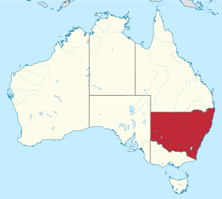
New South Wales is Australia's most populous state, located in the east coast of the continent. It is in the southern hemisphere between latitudes 28 and 38 degrees south of the equator and longitudes 141 and 154 degrees east of the Universal Prime Meridian. The state is in the warm temperate climatic zone.
AFL Victoria Country is an Australian rules football governing body with jurisdiction over the state of Victoria outside metropolitan Melbourne on behalf of AFL Victoria. As well as administering and promoting the code in the regions, it often arbitrates disputes in areas such as player clearances and club movements between country leagues, and may also be called upon as a higher authority of appeal. The organisation was formed as a result of a merger between Victorian Country Football League (VCFL) and AFL Victoria in November 2012.

The South Western Slopes, also known as the South West Slopes, is a region predominantly in New South Wales, Australia. It covers the lower inland slopes of the Great Dividing Range, extending from north of Dunedoo through central NSW and into northeast Victoria, meeting its southwestern end around Beechworth. More than 90% of the region is in the state of New South Wales and it occupies about 10% of that state.
The North West Slopes region of New South Wales, Australia, refers generally to the area west of the Northern Tablelands, to the north of the Central West region and to the east of the Far West region. Despite its name, the region is in north-central New South Wales, corresponding generally to the Australian Bureau of Meteorology's forecast area of North West Slopes and Plains. The administrative areas of the region include the city of Tamworth, Gunnedah, Moree, Narrabri and Inverell.

Esperance Plains, also known as Eyre Botanical District, is a biogeographic region in southern Western Australia on the south coast between the Avon Wheatbelt and Hampton bioregions, and bordered to the north by the Mallee region. It is a plain punctuated by granite and quartz outcrops and ranges, with a semi-arid Mediterranean climate and vegetation consisting mostly of mallee-heath and proteaceous scrub. About half of the region has been cleared for intensive agriculture. Recognised as a bioregion under the Interim Biogeographic Regionalisation for Australia (IBRA), it was first defined by John Stanley Beard in 1980.

Mallee, also known as Roe Botanical District, is a biogeographic region in southern Western Australia. Located between the Esperance Plains, Avon Wheatbelt and Coolgardie bioregions, it has a low, gently undulating topography, a semi-arid mediterranean climate, and extensive Eucalyptus mallee vegetation. It has an area of 73,975.59 square kilometres (28,562.13 sq mi). About half of the region has been cleared for intensive agriculture. Recognised as a region under the Interim Biogeographic Regionalisation for Australia (IBRA), it was first defined by John Stanley Beard in 1980.
In the state of New South Wales, Australia, there are many areas which are commonly known by regional names. Regions are areas that share similar characteristics. These characteristics may be natural such as the Murray River, the coastline, or the Snowy Mountains. Alternatively, the characteristics may be cultural, such as a viticulture land use. New South Wales is divided by numerous regional boundaries, based on different characteristics. In many cases boundaries defined by different agencies are coterminous.
Between 1979 and 1983 almost all of eastern Australia was affected by a major drought.

Victoria is the southernmost mainland state of Australia. With an area of 227,444 km2 (87,817 sq mi), it is Australia's sixth largest state/territory, comparable in size to the island of Great Britain or the U.S. state of Utah. It is bound to the northwest by South Australia, directly north by New South Wales, and also shares a maritime border with Tasmania across the Bass Strait to the south. Most of Victoria's northern border lies along the Murray River. The eastern half of the state is dominated by the Australian Alps and the surrounding highlands of the Great Dividing Range, which also to a lesser extent extend far into the west of the state and ease off after The Grampians. By comparison the north and northwest of the state is extremely flat with little prominence.
The regions of Victoria vary according to the different ways that the Australian state of Victoria is divided into distinct geographic regions. The most commonly used regions are those created by the state government for the purposes of economic development.

The geography of Queensland in the north-east of Australia, is varied. It includes tropical islands, sandy beaches, flat river plains that flood after monsoon rains, tracts of rough, elevated terrain, dry deserts, rich agricultural belts and densely populated urban areas.
In the Australian state of Tasmania, there are many areas which are commonly known by regional names. Regions are areas that share similar characteristics. These characteristics may be natural such as the Furneaux Islands, the coastline, or the Central Highlands. Alternatively, the characteristics may be cultural, such as a viticulture land use. Tasmania is divided by numerous regional boundaries, based on different characteristics. In many cases boundaries defined by different government agencies are coterminous and are often cited by the Australian and local media that tend to distinguish between North West, West Coast, Southern, and East Coast.
In South Australia, one of the states of Australia, there are many areas which are commonly known by regional names. Regions are areas that share similar characteristics. These characteristics may be natural such as the Murray River, the coastline, desert or mountains. Alternatively, the characteristics may be cultural, such as common land use. South Australia is divided by numerous sets of regional boundaries, based on different characteristics. In many cases boundaries defined by different agencies are coterminous.
2022 was an extremely wet year for Australia, coming out of a back-to-back La Niña in the summer of 2021-22, a Negative Indian Ocean Dipole developing over the winter and a third back-to-back La Niña in the spring of 2022.
References
- ↑ "New South Wales Forecast Areas Map". Archived from the original on 12 November 2009. Retrieved 6 November 2006. NSW regions map
- ↑ "Northern Territory Forecast Areas Map". Archived from the original on 5 October 2006. Retrieved 3 October 2006. NT regions map
- ↑ "Queensland Forecast Areas Map". Archived from the original on 5 October 2006. Retrieved 3 October 2006. QLD regions map
- ↑ "South Australian Forecast Areas Map". Archived from the original on 31 August 2009. Retrieved 23 February 2015. SA regions map
- ↑ "Tasmanian Forecast Areas Map". Archived from the original on 5 October 2006. Retrieved 3 October 2006. Tasmania regions map
- ↑ "Victorian Forecast Areas Map". Archived from the original on 31 August 2009. Retrieved 16 October 2010. VIC regions map
- ↑ "Victorian Regions and Regional Cities". Regional Development Victoria. Victorian Government. Archived from the original on 26 July 2014. Retrieved 10 August 2014.
- ↑ "Western Australian Forecast Areas Map". Archived from the original on 2 March 2008. Retrieved 1 March 2008. Western Australia regions