The Coral Sea Islands Territory is an external territory of Australia which comprises a group of small and mostly uninhabited tropical islands and reefs in the Coral Sea, north-east of Queensland, Australia. The only inhabited island is Willis Island. The territory covers 780,000 km2 (301,160 sq mi), most of which is ocean, extending east and south from the outer edge of the Great Barrier Reef and includes Heralds Beacon Island, Osprey Reef, the Willis Group and fifteen other reef/island groups. Cato Island is the highest point in the Territory.
Protected areas of Tasmania consist of protected areas located within Tasmania and its immediate onshore waters, including Macquarie Island. It includes areas of crown land managed by Tasmanian Government agencies as well as private reserves. As of 2016, 52% of Tasmania's land area has some form of reservation classification, the majority is managed by the Tasmania Parks & Wildlife Service. Marine protected areas cover about 7.9% of state waters.
An islet is a very small, often unnamed island. Most definitions are not precise, but some suggest that an islet has little or no vegetation and cannot support human habitation. It may be made of rock, sand and/or hard coral; may be permanent or tidal ; and may exist in the sea, lakes, rivers or any other sizeable bodies of water.
Long Island is a densely populated island in the southeastern geographical area of the State of New York.

Broken Bay, a semi-mature tide-dominated drowned valley estuary, is a large inlet of the Tasman Sea located about 50 kilometres (31 mi) north of Sydney on the Central Coast of New South Wales, Australia; being one of the bodies of water that separate greater Metropolitan Sydney from the Central Coast. Broken Bay is the first major bay north of Sydney Harbour in the state capital of Sydney.
The Hawkesbury River, or Hawkesbury-Nepean River, is a river located northwest of Sydney, New South Wales, Australia. The Hawkesbury River and its associated main tributary, the Nepean River, almost encircle the metropolitan region of Sydney. Between Wisemans Ferry and the Pacific Ocean marks the boundary of Greater Metropolitan Sydney in the south and the Central Coast region to the north.

Port Stephens, an open youthful tide-dominated drowned-valley estuary, is a large natural harbour of approximately 134 square kilometres (52 sq mi) located in the Hunter and Mid North Coast regions of New South Wales, Australia.
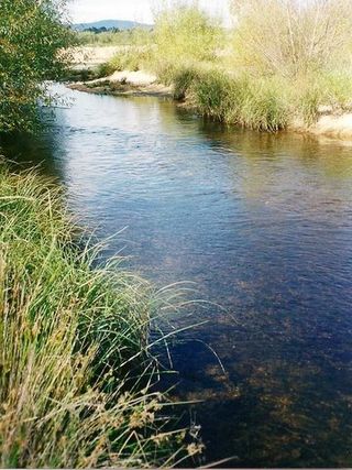
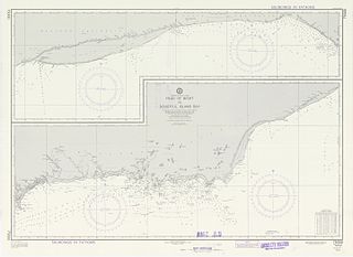
The Shoalhaven River is a perennial river that rises from the Southern Tablelands and flows into an open mature wave dominated barrier estuary near Nowra on the South Coast of New South Wales, Australia.

The Snares Islands, known colloquially as The Snares, is a group of uninhabited islands lying about 200 km (120 mi) south of New Zealand's South Island and to the south-southwest of Stewart Island / Rakiura. The Snares consist of the main North East Island and the smaller Broughton Island and Alert Stack, as well as the Western Chain Islands some 5 km (3.1 mi) to the west-southwest. Collectively, the Snares have a total land area of 3.4 km2 (1.3 sq mi).
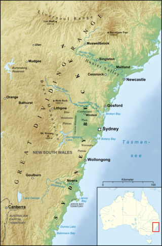
The Sydney Basin is an interim Australian bioregion and is both a structural entity and a depositional area, now preserved on the east coast of New South Wales, Australia and with some of its eastern side now subsided beneath the Tasman Sea. The basin is named for the city of Sydney, on which it is centred.

Maria Island or wukaluwikiwayna in palawa kani is a mountainous island located in the Tasman Sea, off the east coast of Tasmania, Australia. The 115.5-square-kilometre (44.6 sq mi) island is contained within the Maria Island National Park, which includes a marine area of 18.78 square kilometres (7.25 sq mi) off the island's northwest coast. The island is about 20 kilometres (12 mi) in length from north to south and, at its widest, is about 13 kilometres (8.1 mi) west to east. At its closest point, Point Lesueur, the island lies approximately 4 kilometres (2.5 mi) off the east coast of Tasmania.

Pittwater is a semi-mature tide dominated drowned valley estuary, located about 40 kilometres (25 mi) north of the Sydney central business district, New South Wales, Australia; being one of the bodies of water that separate greater Metropolitan Sydney from the Central Coast.
The Ringgold Isles are an archipelago in Fiji, forming an outlier group to Vanua Levu. The Budd, Nukusemanu, and Heemskercq Reefs form part of the group. The group is mostly uninhabited, but Qelelevu has a small village. In 2008 Pacific rats were eradicated from seven islands of the group in an endeavour facilitated by BirdLife International's Fiji Programme.

The geography of Sydney is characterised by its coastal location on a basin bordered by the Pacific Ocean to the east, the Blue Mountains to the west, the Hawkesbury River to the north and the Woronora Plateau to the south. Sydney lies on a submergent coastline on the east coast of New South Wales, where the ocean level has risen to flood deep river valleys (rias) carved in the Sydney sandstone. Port Jackson, better known as Sydney Harbour, is one such ria.
The Archipelago of the Recherche, known locally as the Bay of Isles, is a group of 105 islands, and over 1200 "obstacles to shipping", off the south coast of Western Australia. The islands stretch 230 km (140 mi) from east to west and to 50 km (31 mi) off-shore encompassing an area of approximately 4,000 square kilometres (1,544 sq mi). The western group is near Esperance and the eastern group at Israelite Bay. They are located in coastal waters, part of which is designated the Recherche Archipelago Nature Reserve.

The Nuyts Archipelago is an island group located in South Australia in the Great Australian Bight to the south of the town of Ceduna on the west coast of the Eyre Peninsula. It consisting of mostly granitic islands and reefs that provide breeding sites for Australian sea lions and support colonies of short-tailed shearwater. It also includes the island group known as the Isles of St Francis. All the islands with exception of a part of Evans Island, are located within the following protected areas: the Nuyts Archipelago Wilderness Protection Area and the Nuyts Archipelago Conservation Park.

Nepean Bay is a bay located on the north-east coast of Kangaroo Island in the Australian state of South Australia about 130 kilometres south-south-west of Adelaide. It was named by the British navigator, Matthew Flinders, after Sir Evan Nepean on 21 March 1802.

Captain Cook Cruises is an Australian cruise operator. As of January 2018, the company operated 21 vessels on Sydney Harbour, providing a range of Government contracted and non-contracted Ferry services, Sightseeing, Dining and Charter Cruises.

Western Kangaroo Island Marine Park is a marine protected area in the Australian state of South Australia located in the state’s coastal waters adjoining both the west coast of Kangaroo Island and Lipson Reef, an islet located to the south of Kangaroo Island.