List of islands of Tuvalu

Last updated

Tuvalu consists of nine separate islands: six atolls and three reef islands. [1] An atoll typically consists of several motus: Tuvalu has a total of 124 islands and islets. Each island is surrounded by a coral reef. The soils of Tuvalu's islands are usually shallow, porous, alkaline, coarse-textured, with carbonate mineralogy and high pH values of up to 8.2 to 8.9. [2] The soils are usually deficient in most of the important nutrients needed for plant growth, so garden beds need to be enhanced with mulch to increase their fertility. [2] Tuvalu's small, widely scattered atolls have a total land area of only about 26 square kilometres (10 square miles) making Tuvalu the fourth-smallest country in the world.

Contents

The sea level at the Funafuti tide gauge has been rising at a rate of 3.9 mm per year, and it has been determined that rising sea levels are causing more wave energy to be transferred across reef surfaces, which has tended to push more sand onto island shorelines, increasing islands’ land area. [3] Over a recent four-decade period, there was a net increase in the land area of the islets of 2.9% (73.5 ha), although the changes were not uniform: About 74% of them increased in size and about 27% decreased in size.

Islands of Tuvalu

The islands of Tuvalu are spread out between the latitude of to 10° south and longitude of 176° to 180°, west of the International Date Line. [4]

The name, Tuvalu, means "eight standing together" in Tuvaluan.

The Coral reefs of Tuvalu consists of three reef islands and six atolls, containing approximately 710 km2 (270 sq mi) of reef platforms. [5] The reef islands have a different structure to the atolls, and are perhaps better described as “reef platforms,” as they are small, tabular platforms that lack the salt-water lagoon typically found on reef islands. [6] The reef platforms do have a completely enclosed rim of dry land, and the rim surrounds the remnants of a lagoon, but these lagoon remnants have no connection to the open sea, and tend to dry up as coral debris accumulates in them over time. [7] For example, Niutao has two brackish, saline lakes which are the degraded remnants of an ancient lagoon.

The smallest island, Niulakita, which is the ninth island in the Tuvaluan archipelago, has not been continuously inhabited. It has been privately owned since 1944, when the Gilbert and Ellice Islands Colony administration purchased the island and granted people from Vaitupu permission to settle there. However, in 1949, a successor administration made the controversial decision to expel the Vaitupuans from Niulakita, and arrange for residents of Niutao to settle there instead, because Niutao was considered to be overpopulated. [8] Niulakita is a separate local government district, but it is administered as part of Niutao, and is represented in the Parliament of Tuvalu by members of the constituency of Niutao.

Tv-map.png Flag of Tuvalu-(star interpretation).svg
Atoll/IslandMain
village
Land
area
(km2)
Total
area
(km2)
Pop.
(c. 2017)
Min. number
of islets
Number of
villages
Location
Atolls
Funafuti Vaiaku 2.402776,3203098°31′S 179°13′E
Nanumea Lolua 3.87225125205°41′S 176°09′E
Nui Tanrake 2.831761021407°13′29″S 177°09′37″E
Nukufetau Savave 2.9914559733208°00′S 178°22′E
Nukulaelae Fangaua 1.824330015209°22′52″S 179°51′08″E
Vaitupu Asau 5.60101,0619707°28′S 178°41′E
Islands
Nanumanga Tonga 3.003.0049151)2 06°20′S176°25′E / 6.333°S 176.417°E / -6.333; 176.417
Niulakita Niulakita 0.400.403411 10°45′S179°30′E / 10.750°S 179.500°E / -10.750; 179.500
Niutao Kulia 2.532.5358241)2 06°06′S177°16′E / 6.100°S 177.267°E / -6.100; 177.267
Total
25.4452010,50712434 
1) main island plus islets in landlocked lagoon

At least 11 islands are inhabited, expanded over the biggest isles of the nine atolls, plus two islands in Funafuti. Tuvalu has ISO 3166-2 codes defined for 1 town council (Funafuti) and 7 island councils. Niulakita, which now has its own island council, is not listed as it is administered as part of Niutao.

Royal Society of London investigation of the formation of coral reefs at Funafuti

Coordinates:
8deg19'S 179deg08'E / 8.31degS 179.13degE / -8.31; 179.13 (Funafuti) Tuvalu - Funafuti - Approach.jpg
Coordinates: 8°19′S179°08′E / 8.31°S 179.13°E / -8.31; 179.13 (Funafuti)
The atoll of Funafuti; borings into a coral reef and the results, being the report of the Coral Reef Committee of the Royal Society (1904) The atoll of Funafuti; borings into a coral reef and the results, being the report of the Coral Reef Committee of the Royal Society (1904) (14762635691).jpg
The atoll of Funafuti; borings into a coral reef and the results, being the report of the Coral Reef Committee of the Royal Society (1904)
The atoll of Funafuti; borings into a coral reef and the results, being the report of the Coral Reef Committee of the Royal Society (1904) The atoll of Funafuti; borings into a coral reef and the results, being the report of the Coral Reef Committee of the Royal Society (1904) (14765813295).jpg
The atoll of Funafuti; borings into a coral reef and the results, being the report of the Coral Reef Committee of the Royal Society (1904)

An expedition (Funafuti Coral Reef Boring Expedition of the Royal Society) under Professor William Sollas of Oxford University, conducted by the Royal Society of London carried out drilling on the coral reef at Funafuti in 1896, 1897 and 1898. [9]

HMS Penguin, under the command of Captain Arthur Mostyn Field, delivered the 1896 expedition to Funafuti in the Ellice Islands, arriving on 21 May 1896, and returned to Sydney on 22 August 1896. [7] From 1896 to 1899 the Penguin was under the command of Captain Arthur Mostyn Field and her surveying work included further voyages to Funafuti atoll to deliver the expeditions of the Royal Society in 1897 and 1898. [10] The surveys carried out by the Penguin resulted in the preparation of the Admiralty Nautical Chart 2983 for the islands. [11]

The Royal Society of London were investigating the formation of coral reefs and whether traces of shallow-water organisms could be found at depth in the coral of Pacific atolls. Three expeditions used drilling equipment to take core samples of the coral reef. The boreholes on Fongafale islet are at the site now called Darwin's Drill, [12] A goal of the expeditions was to drill down to confirm that the coral material was located on a base of volcanic rock. This investigation followed the work on the structure and distribution of coral reefs conducted by Charles Darwin in the Pacific. However, the geologic history of atolls is more complex than Darwin (1842) and Davis (1928) envisioned. [13]

First expedition (1896)

The expedition was led by Professor William Johnson Sollas of the University of Oxford and included Professor Edgeworth David and Walter George Woolnough of the University of Sydney. [9] [14]

Second expedition (1897)

The expedition was led by Professor Edgeworth David of the University of Sydney (that included George Sweet as second-in-command, and Walter George Woolnough). [15]

Third expedition (1898)

The expedition was led by Alfred Edmund Finckh of the University of Sydney. [16] [17]

Results of the Royal Society expeditions

The purpose of the expedition was to attempt to settle the question as to the formation of coral atolls. The first expedition experienced defects in the boring machinery and the bore penetrated only slightly more than 100 feet (approx. 31 m). The second expedition reached a depth of 557 feet (170 m). The third expedition was successful in carrying the bore to 1,114 feet (340 m). [18] [19] The results provided support for Charles Darwin's theory of subsidence; [20] in which there are four stages in development of coral reefs: a volcanic island forms, is surrounded by a fringing coral reef, as it subsides slowly a wide barrier reef forms, then after it has sunk below sea level the coral continues to grow forming a circular atoll. However, the geologic history of atolls is more complex than Darwin (1842) and Davis (1920 & 1928) envisioned. [13]

Structure of Funafuti atoll

Funafuti atoll Funafuti.jpg
Funafuti atoll

The average depth in the Funafuti lagoon (Te Namo) is about 20 fathoms (36.5 metres or 120 feet). [21]

Funafuti is an almost circular and conical submarine mountain 12,000 feet high, originally volcanic, and of immense geological age, much older than the relatively young and active mountains of the New Hebrides and Solomons. At its base on the ocean bed it is 30 miles wide in one of the directions tested, and 28 miles wide on the other. It rises in a gentle slope which gradually steepens to a point 2,400 feet below water level, after which it rises at an angle of 80 degrees to 840 feet below water level. From this point it rises vertically, like an enormous pillar, till reaches the surface in the form of a reef enclosing a lagoon of irregular size, but of which the extremities give a measurement of 13.5 by 10.0 miles”. [21]

See also

Related Research Articles

<span class="mw-page-title-main">Tuvalu</span> Country in Oceania

Tuvalu, formerly known as the Ellice Islands, is an island country in the Polynesian subregion of Oceania in the Pacific Ocean, about midway between Hawaii and Australia. It lies east-northeast of the Santa Cruz Islands, northeast of Vanuatu, southeast of Nauru, south of Kiribati, west of Tokelau, northwest of Samoa and Wallis and Futuna, and north of Fiji.

<span class="mw-page-title-main">Geography of Tuvalu</span> Overview of the geography of Tuvalu

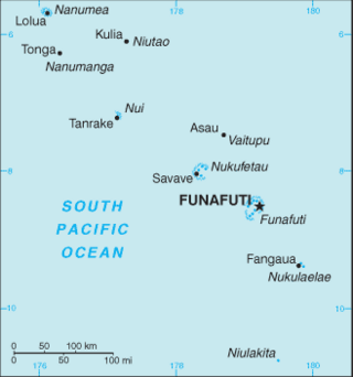
The Western Pacific nation of Tuvalu, formerly known as the Ellice Islands, is situated 4,000 kilometers (2,500 mi) northeast of Australia and is approximately halfway between Hawaii and Australia. It lies east-northeast of the Santa Cruz Islands, southeast of Nauru, south of Kiribati, west of Tokelau, northwest of Samoa and Wallis and Futuna and north of Fiji. It is a very small island country of 26 km2 (10 sq mi). Due to the spread out islands it has the 38th largest Exclusive Economic Zone of 749,790 km2 (289,500 sq mi). In terms of size, it is the second-smallest country in Oceania.

<span class="mw-page-title-main">Atoll</span> Ring-shaped coral reef

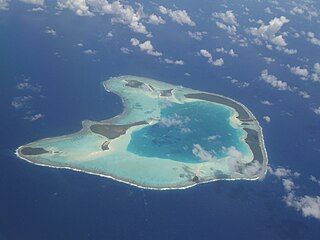
An atoll is a ring-shaped island, including a coral rim that encircles a lagoon. There may be coral islands or cays on the rim. Atolls are located in warm tropical or subtropical parts of the oceans and seas where corals can develop. Most of the approximately 440 atolls in the world are in the Pacific Ocean.

<span class="mw-page-title-main">History of Tuvalu</span>

The first inhabitants of Tuvalu were Polynesians, so the origins of the people of Tuvalu can be traced to the spread of humans out of Southeast Asia, from Taiwan, via Melanesia and across the Pacific islands of Polynesia.

<span class="mw-page-title-main">Fongafale</span> Island in Funafuti, Tuvalu

Fongafale is the largest of Funafuti's islets in Tuvalu. It is a long narrow sliver of land, 12 kilometres long and between 10 and 400 metres wide, with the South Pacific Ocean and reef on the east and the protected lagoon on the west. The north part is the Tengako peninsula, and Funafuti International Airport runs from northeast to southwest on the widest part of the island, with the village and administrative centre of Vaiaku on the lagoon side.

<span class="mw-page-title-main">Edgeworth David</span> Welsh-Australian geologist (1858–1934)

Sir Tannatt William Edgeworth David was a Welsh Australian geologist and Antarctic explorer. A household name in his lifetime, David's most significant achievements were discovering the major Hunter Valley coalfield in New South Wales and leading the first expedition to reach the South Magnetic Pole. He also served with distinction in World War I.

<span class="mw-page-title-main">Tepuka</span> Island in Funafuti atoll, Tuvalu

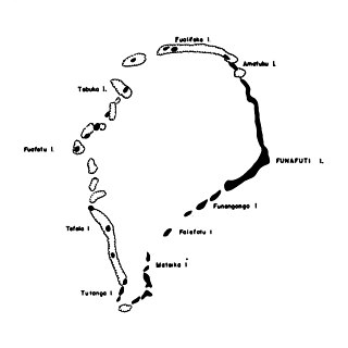
Tepuka is an island eighteen kilometers west of Fongafale, in the northwest of Funafuti, the main atoll of the Oceanian nation of Tuvalu. Te puka, or Pouka, is the name of a tree - Hernandia peltata.

<span class="mw-page-title-main">William Johnson Sollas</span> British geologist and anthropologist

Prof William Johnson Sollas PGS FRS FRSE LLD was a British geologist and anthropologist. After studying at the City of London School, the Royal College of Chemistry and the Royal School of Mines he matriculated to St. John's College, Cambridge, where he was awarded First Class Honours in geology. After some time spent as a University Extension lecturer he became lecturer in Geology and Zoology at University College, Bristol in 1879, where he stayed until he was offered the post of Professor of Geology at Trinity College Dublin. In 1897 he was offered the post of Professor of Geology at the University of Oxford, which he accepted.

Funafala is an islet of Funafuti, Tuvalu that is inhabited by five families, with a church also located on the islet. Funafala means 'the pandanus of Funa', the name of a chief, after whom also the group has been named Funafuti.

<span class="mw-page-title-main">Tepuka Vili Vili</span> Islet in Tuvalu

Tepuka Vili Vili or Tepuka Savilivili is an islet of Funafuti, Tuvalu.

<span class="mw-page-title-main">Tutanga</span> Islet in Funafuti atoll, Tuvalu

Tutanga is an uninhabited islet which is the most southern islet of Funafuti, Tuvalu. This islet has also been called Tuaeriki.

<span class="mw-page-title-main">Tuvalu–United States relations</span> Bilateral relations

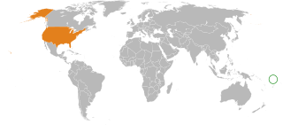
Tuvalu – United States relations are bilateral relations between Tuvalu and the United States.

<span class="mw-page-title-main">Outline of Tuvalu</span> Overview of and topical guide to Tuvalu

The following outline is provided as an overview of and topical guide to Tuvalu:

<span class="mw-page-title-main">Funafuti</span> Atoll and one of nine districts of Tuvalu

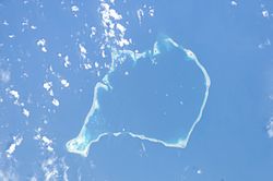
Funafuti is the capital of the island nation of Tuvalu. It has a population of 6,320 people, and so it has more people than the rest of Tuvalu combined, with approximately 60% of the population. It consists of a narrow sweep of land between 20 and 400 metres wide, encircling a large lagoon 18 km long and 14 km wide. The average depth of the Funafuti lagoon is about 20 fathoms. With a surface area of 275 square kilometres (106.2 sq mi), it is by far the largest lagoon in Tuvalu. The land area of the 33 islets around the atoll of Funafuti totals 2.4 square kilometres (0.9 sq mi); taken together, they constitute less than one percent of the total area of the atoll. Cargo ships can enter Funafuti's lagoon and dock at the port facilities on Fongafale.

<i>The Structure and Distribution of Coral Reefs</i> Book published in 1842 by Charles Darwin

The Structure and Distribution of Coral Reefs, Being the first part of the geology of the voyage of the Beagle, under the command of Capt. Fitzroy, R.N. during the years 1832 to 1836, was published in 1842 as Charles Darwin's first monograph, and set out his theory of the formation of coral reefs and atolls. He conceived of the idea during the voyage of the Beagle while still in South America, before he had seen a coral island, and wrote it out as HMS Beagle crossed the Pacific Ocean, completing his draft by November 1835. At the time there was great scientific interest in the way that coral reefs formed, and Captain Robert FitzRoy's orders from the Admiralty included the investigation of an atoll as an important scientific aim of the voyage. FitzRoy chose to survey the Keeling Islands in the Indian Ocean. The results supported Darwin's theory that the various types of coral reefs and atolls could be explained by uplift and subsidence of vast areas of the Earth's crust under the oceans.

<span class="mw-page-title-main">Climate change in Tuvalu</span> Emissions, impacts and responses of Tuvalu related to climate change

Climate change is particularly threatening for the long-term habitability of the island country of Tuvalu, which has a land area of only 26 square kilometres (10 sq mi) and an average elevation of less than 2 metres (6.6 ft) above sea level, with the highest point of Niulakita being about 4.6 metres (15 ft) above sea level. Potential threats to the country due to climate change include rising sea levels, increasingly severe tropical cyclones, high temperatures, and drought. King tides can combine with storm surges and the rising sea level to inundate the low lying atolls.

The Funafuti Conservation Area is a marine conservation area covering 33 square kilometers of reef, lagoon and motu (islets) on the western side of Funafuti atoll in Tuvalu. The marine environment of the conservation area includes reef, lagoon, channel and ocean; and are home to many species of fish, corals, algae and invertebrates. The islets are nesting sites for the green sea turtle and Fualopa hosts a breeding colony of black noddy.

<span class="mw-page-title-main">Tuvaluan mythology</span>

Tuvaluan mythology tells stories of the creation of the islands of Tuvalu and of the founding ancestors of each island. While on some of the islands there are stories of spirits creating the islands, a creation story that is found on many of the islands is that te Pusi mo te Ali created the islands of Tuvalu; te Ali is believed to be the origin of the flat atolls of Tuvalu and te Pusi is the model for the coconut palms that are important in the lives of Tuvaluans. The strength of this belief has the consequence that Moray eel are tapu and are not eaten.

<span class="mw-page-title-main">Coral reefs of Tuvalu</span> List of coral reefs in Tuvalu

The coral reefs of Tuvalu consist of three reef islands and six atolls, containing approximately 710 km2 (270 sq mi) of reef platforms. The islands of the Tuvalu archipelago are spread out between the latitude of 5° to 10° south and longitude of 176° to 180°, west of the International Date Line. The islands of Tuvalu are volcanic in origin. On the atolls, an annular reef rim surrounds the lagoon, and may include natural reef channels. The reef islands have a different structure to the atolls, and are described as reef platforms as they are smaller tabular reef platforms that do not have a salt-water lagoon, although they may have a completely closed rim of dry land, with the remnants of a lagoon that has no direct connection to the open sea or that may be drying up.

<span class="mw-page-title-main">Protected areas of Tuvalu</span> Protected areas in Tuvalu

Protected areas of Tuvalu consist of protected areas located within the central Pacific country of Tuvalu and its territorial waters. One such area is the Funafuti Conservation Area, which is a marine protected area on the western reef area of Funafuti atoll.

References

  1. "EU-SOPAC Project Report 50: TUVALU TECHNICAL REPORT High-Resolution Bathymetric Survey Fieldwork undertaken from 19 September to 24 October 2004" (PDF). Pacific Islands Applied Geoscience Commission c/o SOPAC Secretariat. October 2018. Retrieved 21 October 2019.
  2. 1 2 "Tuvalu Fifth National Report to the Convention on Biological Diversity". Government of Tuvalu. 2016. Retrieved 11 November 2023.
  3. Paul S. Kench, Murray R. Ford & Susan D. Owen (9 February 2018). "Patterns of island change and persistence offer alternate adaptation pathways for atoll nations". Nature Communications. 9 (1): 605. doi:10.1038/s41467-018-02954-1. PMC   5807422 . PMID   29426825.
  4. "Maps of Tuvalu" . Retrieved 15 January 2021.
  5. Morris, C., & Mackay, K. (2008). Status of coral reefs in the Southwest Pacific: Fiji, Nauru, New Caledonia, Samoa, Solomon Islands, Tuvalu and Vanuatu (Report). Status of coral reefs of the world (Townsville: Australian Institute of Marine Science). pp. 177–188.{{cite report}}: CS1 maint: multiple names: authors list (link)
  6. Paul S. Kench, Murray R. Ford & Susan D. Owen (9 February 2018). "Patterns of island change and persistence offer alternate adaptation pathways for atoll nations (Supplementary Note 1)". Nature Communications. 9 (1): 605. doi:10.1038/s41467-018-02954-1. PMC   5807422 . PMID   29426825. S2CID   256641955 . Retrieved 11 February 2018.
  7. 1 2 Hedley, Charles (1896). "General account of the Atoll of Funafuti" (PDF). Australian Museum Memoir. 3 (2): 1–72. doi:10.3853/j.0067-1967.3.1896.487.
  8. "Foua Tofiga". tighar.org. Archived from the original on 2 February 2017. Retrieved 26 April 2015.
  9. 1 2 Sollas, William J. (1899). "Funafati: the study of a coral atoll". Natural Science. 14: 17–37.
  10. Admiral Sir Arthur Mostyn Field (1855–1950) from nmm.ac.uk
  11. Admiralty Nautical Chart 2983. United Kingdom Hydrographic Office (UKHO).
  12. Lal, Andrick. South Pacific Sea Level & Climate Monitoring Project – Funafuti atoll (PDF). SPC Applied Geoscience and Technology Division (SOPAC Division of SPC). pp. 35 & 40. Archived from the original (PDF) on 3 February 2014.
  13. 1 2 Dickinson, William R. (2009). "Pacific Atoll Living: How Long Already and Until When?" (PDF). GSA Today. 19 (3): 4–10. doi: 10.1130/GSATG35A.1 .
  14. Dr. Alfred Edmund Finckh (11 September 1934). "TO THE EDITOR OF THE HERALD". The Sydney Morning Herald . National Library of Australia. p. 6. Retrieved 20 June 2012.
  15. David, Mrs Edgeworth, Funafuti or Three Months On A Coral Atoll: an unscientific account of a scientific expedition, London: John Murray, 1899
  16. Cantrell, Carol. Finckh, Alfred Edmund (1866–1961). Australian Dictionary of Biography, National Centre of Biography, Australian National University. Retrieved 23 December 2012.
  17. K. A. Rodgers and Carol Cantrell (1989). "Alfred Edmund Finckh 1866-1961: Leader of the 1898 Coral Reef Boring Expedition to Funafuti" (PDF). Historical Records of Australian Science. 7 (4). Historical Records of Australian Science, Volume 7, Number 4, pp. 393–403: 393–403. doi:10.1071/hr9890740393. PMID   11617111 . Retrieved 23 December 2012.
  18. The Funafuti Coral-Boring Expedition, Address by Professor David (PDF). The Sydney Morning Herald. 11 December 1897.
  19. "TO THE EDITOR OF THE HERALD". The Sydney Morning Herald . National Library of Australia. 11 September 1934. p. 6. Retrieved 20 June 2012.
  20. "CORAL FORMATION". The Argus . Melbourne: National Library of Australia. 10 December 1897. p. 5. Retrieved 19 June 2012.
  21. 1 2 Coates, A. (1970). Western Pacific Islands. H.M.S.O. p. 349.