Beach, North Dakota | |
---|---|
Coordinates: 46°54′57″N104°00′16″W / 46.91583°N 104.00444°W | |
Country | United States |
State | North Dakota |
County | Golden Valley |
Settled | 1900 |
Incorporated (village) | 1908 |
Incorporated (city) | 1909 |
Named for | Capt. Warren C. Beach |
Government | |
• Mayor | Walter Losinski |
Area | |
• Total | 2.57 sq mi (6.67 km2) |
• Land | 2.55 sq mi (6.61 km2) |
• Water | 0.02 sq mi (0.06 km2) |
Elevation | 2,776 ft (846 m) |
Population | |
• Total | 981 |
• Estimate (2022) [4] | 977 |
• Density | 384.40/sq mi (148.40/km2) |
Time zone | UTC-7 (Mountain (MST)) |
• Summer (DST) | UTC-6 (MDT) |
ZIP code | 58621 |
Area code | 701 |
FIPS code | 38-05420 |
GNIS feature ID | 1027837 [5] |
Highways | I-94, ND 16 |
Website | beachnd.com |
Beach is a city in and the county seat of Golden Valley County in the State of North Dakota. [6] The population was 981 at the 2020 census. [3] Beach was incorporated in 1909. Walter Losinski was elected mayor of Beach in June 2022. [7]
Beach was first settled circa 1900. It was named for Captain Warren C. Beach of the U.S. Army's 11th Infantry. Beach had led an expedition of railroad surveyors through the area in 1880. The post office was established in 1902, and the town was incorporated first as a village in 1908 and as a city in 1909. It was named the county seat of Golden Valley County in 1912. [1]
In April 1911, the then ex-president and long-term fixture of the Badlands region, Theodore Roosevelt, made his last trip to the area, stopping in Beach and nearby Medora. His visit to Medora passed without incident, but the visit to Beach was marred by a strongly negative reception to Roosevelt's speech. He first expressed surprise that the town of Beach even existed, based upon such marginal land. This was undoubtedly due to the lack of flora and fauna, the wear and strain he endured in the 10 years he ranched in the area, and Rocky Mountain and Great Plains blizzard of 1886–7. [8] [9] [10] Roosevelt's speech had a strong conservationist element, suggesting to local ranchers there should only be one cow for every 12 acres (49,000 m2) of land, which led to local disenchantment with the president.
The incident is likely to have critically influenced his commentary and estrangement with the region, culminating in October 1918. While giving a morale speech regarding World War I in then strongly anti-war North Dakota, a side trip to the Badlands was suggested. Roosevelt demurred, stating "[i]t is a mistake for one to hit the back trail after many years have passed. One finds things have changed, the old picture destroyed, the romance gone . . . It's best that it should be so, but I don't want to see the place again. I'd rather try and remember it as it was." [11]
Beach is located in western North Dakota along the border with Montana. According to the United States Census Bureau, the city has a total area of 1.93 square miles (5.00 km2), all land. [12]
Census | Pop. | Note | %± |
---|---|---|---|
1910 | 1,003 | — | |
1920 | 1,106 | 10.3% | |
1930 | 1,263 | 14.2% | |
1940 | 1,178 | −6.7% | |
1950 | 1,461 | 24.0% | |
1960 | 1,460 | −0.1% | |
1970 | 1,408 | −3.6% | |
1980 | 1,381 | −1.9% | |
1990 | 1,205 | −12.7% | |
2000 | 1,116 | −7.4% | |
2010 | 1,019 | −8.7% | |
2020 | 981 | −3.7% | |
2022 (est.) | 977 | [4] | −0.4% |
U.S. Decennial Census [13] 2020 Census [3] |
As of the census of 2010, there were 1,019 people, 498 households, and 251 families living in the city. The population density was 528.0 inhabitants per square mile (203.9/km2). There were 601 housing units at an average density of 311.4 per square mile (120.2/km2). The racial makeup of the city was 97.4% White, 0.6% African American, 0.4% Native American, 0.1% Asian, 0.1% Pacific Islander, 0.7% from other races, and 0.7% from two or more races. Hispanic or Latino of any race were 2.2% of the population.
There were 498 households, of which 23.1% had children under the age of 18 living with them, 42.6% were married couples living together, 5.2% had a female householder with no husband present, 2.6% had a male householder with no wife present, and 49.6% were non-families. 43.8% of all households were made up of individuals, and 22.9% had someone living alone who was 65 years of age or older. The average household size was 2.05 and the average family size was 2.90.
The median age in the city was 46.2 years. 22.5% of residents were under the age of 18; 5.4% were between the ages of 18 and 24; 20% were from 25 to 44; 29.2% were from 45 to 64; and 23% were 65 years of age or older. The gender makeup of the city was 47.3% male and 52.7% female.
As of the census of 2000, there were 1,116 people, 470 households, and 292 families living in the city. [14] The population density was 610.3 inhabitants per square mile (235.6/km2). There were 570 housing units at an average density of 311.7 per square mile (120.3/km2). The racial makeup of the city was 98.66% White, 0.18% Native American, 0.18% Asian, 0.54% from other races, and 0.45% from two or more races. Hispanic or Latino of any race were 0.99% of the population.
There were 470 households, out of which 28.3% had children under the age of 18 living with them, 51.7% were married couples living together, 7.0% had a female householder with no husband present, and 37.7% were non-families. 36.0% of all households were made up of individuals, and 19.1% had someone living alone who was 65 years of age or older. The average household size was 2.29 and the average family size was 3.00.
In the city, the population was spread out, with 25.4% under the age of 18, 5.4% from 18 to 24, 22.0% from 25 to 44, 21.6% from 45 to 64, and 25.6% who were 65 years of age or older. The median age was 43 years. For every 100 females, there were 80.6 males. For every 100 females age 18 and over, there were 76.3 males.
The median income for a household in the city was $28,977, and the median income for a family was $35,536. Males had a median income of $25,515 versus $17,857 for females. The per capita income for the city was $14,450. About 10.9% of families and 17.6% of the population were below the poverty line, including 31.6% of those under age 18 and 7.2% of those age 65 or over.
According to the Köppen Climate Classification system, Beach has a borderline humid continental climate, abbreviated Dfb on climate maps, and it closely borders upon a cool semi-arid climate, abbreviated BSk. [15]
Climate data for Beach, North Dakota, 1991–2020 normals, extremes 1906–2011 | |||||||||||||
---|---|---|---|---|---|---|---|---|---|---|---|---|---|
Month | Jan | Feb | Mar | Apr | May | Jun | Jul | Aug | Sep | Oct | Nov | Dec | Year |
Record high °F (°C) | 61 (16) | 68 (20) | 84 (29) | 93 (34) | 99 (37) | 106 (41) | 110 (43) | 108 (42) | 102 (39) | 93 (34) | 79 (26) | 67 (19) | 110 (43) |
Mean maximum °F (°C) | 48.5 (9.2) | 52.8 (11.6) | 67.0 (19.4) | 77.6 (25.3) | 85.4 (29.7) | 92.2 (33.4) | 97.5 (36.4) | 96.2 (35.7) | 92.6 (33.7) | 79.5 (26.4) | 64.1 (17.8) | 49.0 (9.4) | 99.7 (37.6) |
Mean daily maximum °F (°C) | 27.3 (−2.6) | 31.0 (−0.6) | 43.1 (6.2) | 56.3 (13.5) | 67.4 (19.7) | 76.5 (24.7) | 84.6 (29.2) | 85.0 (29.4) | 73.9 (23.3) | 56.5 (13.6) | 40.9 (4.9) | 30.2 (−1.0) | 56.1 (13.4) |
Daily mean °F (°C) | 16.8 (−8.4) | 20.7 (−6.3) | 31.7 (−0.2) | 43.0 (6.1) | 54.0 (12.2) | 63.5 (17.5) | 70.1 (21.2) | 69.5 (20.8) | 59.4 (15.2) | 44.4 (6.9) | 30.6 (−0.8) | 20.3 (−6.5) | 43.7 (6.5) |
Mean daily minimum °F (°C) | 6.2 (−14.3) | 10.4 (−12.0) | 20.3 (−6.5) | 29.7 (−1.3) | 40.5 (4.7) | 50.5 (10.3) | 55.6 (13.1) | 53.9 (12.2) | 44.9 (7.2) | 32.3 (0.2) | 20.3 (−6.5) | 10.4 (−12.0) | 31.3 (−0.4) |
Mean minimum °F (°C) | −18.3 (−27.9) | −12.9 (−24.9) | −3.4 (−19.7) | 12.8 (−10.7) | 25.7 (−3.5) | 38.0 (3.3) | 45.3 (7.4) | 40.5 (4.7) | 28.3 (−2.1) | 12.7 (−10.7) | −1.1 (−18.4) | −17.3 (−27.4) | −26.5 (−32.5) |
Record low °F (°C) | −40 (−40) | −43 (−42) | −40 (−40) | −8 (−22) | 10 (−12) | 26 (−3) | 32 (0) | 29 (−2) | 11 (−12) | −15 (−26) | −20 (−29) | −38 (−39) | −43 (−42) |
Average precipitation inches (mm) | 0.53 (13) | 0.50 (13) | 0.79 (20) | 1.70 (43) | 2.36 (60) | 2.50 (64) | 2.47 (63) | 1.56 (40) | 1.81 (46) | 1.27 (32) | 0.49 (12) | 0.52 (13) | 16.5 (419) |
Average snowfall inches (cm) | 5.0 (13) | 5.5 (14) | 5.2 (13) | 4.1 (10) | 1.9 (4.8) | 0.0 (0.0) | 0.0 (0.0) | 0.0 (0.0) | 0.1 (0.25) | 2.5 (6.4) | 3.3 (8.4) | 5.2 (13) | 32.8 (82.85) |
Average precipitation days (≥ 0.01 in) | 3.9 | 3.5 | 4.4 | 5.4 | 8.3 | 9.1 | 7.1 | 4.9 | 4.9 | 4.5 | 3.4 | 3.8 | 63.2 |
Average snowy days (≥ 0.1 in) | 3.1 | 3.3 | 2.8 | 1.6 | 0.6 | 0.0 | 0.0 | 0.0 | 0.2 | 0.7 | 2.1 | 3.4 | 17.8 |
Source: NOAA (mean maxima/minima, snow/snow days 1981–2010) [16] [17] [18] |
Wibaux is a town in and the county seat of Wibaux County, Montana, United States. It is the only incorporated town in Wibaux County. The population was 462 at the 2020 census.
Medora is a city in Billings County, North Dakota, United States. The only incorporated place in Billings County, it is also the county seat. Much of the surrounding area is part of either Little Missouri National Grassland or Theodore Roosevelt National Park. The population was 121 at the 2020 census. It is part of the Dickinson Micropolitan Statistical Area.
Lansford is a city in Bottineau County, North Dakota, United States. The population was 238 at the 2020 census. Lansford was founded in 1903.
Newburg is a city in Bottineau County, North Dakota, United States. The population was 96 at the 2020 census. Newburg was founded in 1906.
Columbus is a city in Burke County, North Dakota, United States. The population was 139 at the 2020 census. Columbus was founded in 1906. Both this town and nearby Larson were named for an early postmaster who served the area, making it possibly the only town so named that was not named for Christopher Columbus.
Powers Lake is a city in Burke County, North Dakota, United States. The population was 385 at the 2020 census. Powers Lake was founded in 1909.
Munich is a city in Cavalier County, North Dakota, United States. The population was 190 at the 2020 census. The city was named after Munich, Germany.
Halliday is a city in Dunn County, North Dakota, United States. The population was 241 at the 2020 census. Halliday was founded in 1914.
Velva is a city in McHenry County, North Dakota, United States. Part of the Minot Micropolitan Statistical Area, it was founded in 1897 and the population was 1,086 at the 2020 census. Southeast of Minot, Velva is at the southernmost point of the Souris River.
Watford City, founded in 1914, is a city in and the county seat of McKenzie County, North Dakota, United States. The population was 6,207 at the 2020 census, making it the 13th most populous city in North Dakota. Because Watford City is part of the Bakken field, the North Dakota oil boom has significantly increased population and construction since the 2010 census.
Underwood is a city in McLean County, North Dakota, United States. The population was 784 at the 2020 census.
Washburn is a city in southern McLean County, North Dakota, United States. Located along the upper Missouri River, it is the county seat of McLean County. The population was 1,300 at the 2020 census.
Hankinson is a city in Richland County, North Dakota, United States. The population was 921 at the 2020 census. Hankinson was founded in 1886. It is part of the Wahpeton, ND–MN Micropolitan Statistical Area.
Lidgerwood is a city in Richland County, North Dakota, United States. The population was 600 at the 2020 census. Lidgerwood was founded in 1886. It is part of the Wahpeton, ND–MN Micropolitan Statistical Area.
Dickinson is a city in and the county seat of Stark County, North Dakota, United States. The population was 25,679 at the 2020 census, and was estimated to be 24,979 in 2022, making it the 7th most populous city in North Dakota. Dickinson is home to the Ukrainian Cultural Institute, which has a museum and holds events year round for the local Ukrainian community. Western North Dakota has a high concentration of people of Ukrainian descent.
Sharon is a city in Steele County, North Dakota, United States. The population was 86 at the 2020 census. Sharon was founded in 1896.
Edgemont is a city in Fall River County, South Dakota, United States. The population was 725 at the 2020 census. The city lies on the far southern edge of the Black Hills in southwestern South Dakota.
Parkston is a city in Hutchinson County, South Dakota, United States. The population was 1,567 at the 2020 census.
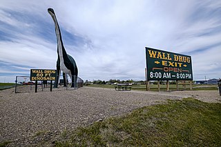
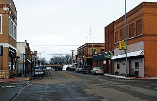
Wall is a town in Pennington County, South Dakota, United States. The population was 699 at the 2020 census.
Wasta(Lakota: wašté) is a town in Pennington County, South Dakota, United States, situated along the Cheyenne River. It had a population of 65 at the 2020 census.
{{cite web}}
: CS1 maint: numeric names: authors list (link)[ dead link ]