West Fargo, North Dakota | |
---|---|
Motto: "A City on the Grow" | |
Coordinates: 46°52′20″N96°52′18″W / 46.87222°N 96.87167°W | |
Country | United States |
State | North Dakota |
County | Cass |
Government | |
• Mayor | Bernie Dardis |
Area | |
• Total | 16.42 sq mi (42.52 km2) |
• Land | 16.18 sq mi (41.89 km2) |
• Water | 0.24 sq mi (0.63 km2) |
Elevation | 899 ft (274 m) |
Population | |
• Total | 38,626 |
• Estimate (2022) [4] | 39,985 |
• Rank | US: 999th ND: 5th |
• Density | 2,388.01/sq mi (922.03/km2) |
• Demonym | West Fargoan |
Time zone | UTC-6 (Central (CST)) |
• Summer (DST) | UTC-5 (CDT) |
ZIP code | 58078 |
Area code | 701 |
FIPS code | 38-84780 |
GNIS feature ID | 1036321 [2] |
Highways | I-94, US 10 |
Website | westfargond.gov |
West Fargo is a city in Cass County, North Dakota, United States. It is, as of the 2020 census, the fifth most populous city in the state of North Dakota with a population of 38,626, [3] and it is one of the state's fastest growing cities. [5] The city is part of the Fargo-Moorhead, ND-MN Metropolitan Statistical Area.
West Fargo began as a whistle stop called "Sheyenne Crossing" on the Northern Pacific Railway, named for the nearby Sheyenne River. [6] [7] [8]
A post office operated from 1874 to 1885. [6]
The settlement was renamed "Haggartville", and then "Haggart", after the owner of the land, John E. Haggart, a businessman who served as postmaster, U.S. marshall, and first sheriff of Cass County. [6] [9] Settlers began arriving in the area, and in 1876 the first school was built, School District No. 6. [9]
Equity Co-op Packing Company was formed by a group of farmer, and the Equity Packing Plant—a meat processing plant—was erected in the settlement in 1919. [9] Twenty-four homes were built, as well as a hotel, restaurant, and general store. [9] [10] The Equity company fell into bankruptcy in 1922, and was sold to Armour and Company in 1925, when the settlement's name was changed to "Village of West Fargo". [9] The settlement was a major agricultural processor during the 1930s, and most of the residents were meat packinghouse workers; teams at West Fargo High School continue to be called the "packers". [11] The plant utilized an assembly line to process meat, and its motto stated it used "every part of the animal except the squeal." [10] The plant also produced fertilizer, adhesives, and soap. [10] The meat packing era ended in West Fargo when the Armour plant closed in 1960. [10]
In 1989, the cities of West Fargo and Riverside merged. [9]
According to the United States Census Bureau, the city has a total area of 14.72 square miles (38.12 km2), of which 14.44 square miles (37.40 km2) is land and 0.28 square miles (0.73 km2) is water. [12]
This climatic region is typified by large seasonal temperature differences, with warm (and often humid) summers and cold (sometimes severely cold) winters. According to the Köppen Climate Classification system, West Fargo has a humid continental climate, abbreviated "Dfb" on climate maps. [13]
Census | Pop. | Note | %± |
---|---|---|---|
1940 | 707 | — | |
1950 | 1,632 | 130.8% | |
1960 | 3,328 | 103.9% | |
1970 | 5,161 | 55.1% | |
1980 | 10,099 | 95.7% | |
1990 | 12,287 | 21.7% | |
2000 | 14,940 | 21.6% | |
2010 | 25,830 | 72.9% | |
2020 | 38,626 | 49.5% | |
2022 (est.) | 39,985 | [4] | 3.5% |
U.S. Decennial Census [14] 2020 Census [3] |
According to the 2008–2012 American Community Survey 5-Year Estimates, the ancestry is as follows:
As of the census of 2010, [16] there were 25,830 people, 10,348 households and 6,823 families residing in the city. The population density was 1,788.8 inhabitants per square mile (690.7/km2). There were 10,760 housing units at an average density of 745.2 per square mile (287.7/km2). The racial makeup was 93.5% White, 2.0% African American, 1.0% Native American, 1.4% Asian, 0.4% from other races, and 1.8% from two or more races. Hispanic or Latino of any race were 1.8% of the population.
There were 10,348 households, of which 36.2% had children under the age of 18 living with them, 52.8% were married couples living together, 9.1% had a female householder with no husband present, 4.0% had a male householder with no wife present, and 34.1% were non-families. 26.4% of all households were made up of individuals, and 6.6% had someone living alone who was 65 years of age or older. The average household size was 2.49 and the average family size was 3.04.
The median age was 32.6 years. 26.9% of residents were under the age of 18; 9.3% were between the ages of 18 and 24; 32.9% were from 25 to 44; 23.2% were from 45 to 64; and 7.8% were 65 years of age or older. The gender makeup of the city was 49.6% male and 50.4% female.
As of the census of 2000, there were 14,940 people, 5,771 households and 4,091 families residing in the city. The population density was 2,049.2 inhabitants per square mile (791.2/km2). There were 5,968 housing units at an average density of 818.6 per square mile (316.1/km2). The racial makeup was 96.40% White, 0.42% African American, 1.04% Native American, 0.28% Asian, 0.02% Pacific Islander, 0.67% from other races, and 1.16% from two or more races. Hispanic or Latino of any race were 1.41% of the population.
The top six ancestry groups in the city are German (47.9%), Norwegian (39.7%), Irish (8.3%), Swedish (7.2%), French (5.2%), English (4.8%).
There were 5,771 households, of which 40.1% had children under the age of 18 living with them, 57.3% were married couples living together, 9.9% had a female householder with no husband present, and 29.1% were non-families. 23.7% of all households were made up of individuals, and 5.9% had someone living alone who was 65 years of age or older. The average household size was 2.59 and the average family size was 3.09.
29.2% of the population were under the age of 18, 8.9% from 18 to 24, 34.0% from 25 to 44, 21.2% from 45 to 64, and 6.7% who were 65 years of age or older. The median age was 32 years. For every 100 females, there were 97.4 males. For every 100 females age 18 and over, there were 94.4 males.
The median household income was $44,542 and the median family income was $51,765. Males had a median income of $32,105 and females $22,148. The per capita income was $19,368. About 4.7% of families and 6.3% of the population were below the poverty line, including 7.8% of those under age 18 and 14.8% of those age 65 or over.
Technology companies with West Fargo locations include:
Annual events and sites of interest:
The West Fargo Public Library is located in the Clayton A. Lodoen Center. The library moved into this facility in 2005. [33]
The West Fargo Park District maintains 30 parks, bike paths, and facilities that include Scheels Soccer Complex, Veterans Memorial Arena, Rustad Recreation Center and Veterans Memorial Pool. [34]
The City of West Fargo is governed by a Board of City Commissioners, which consists of the President of the Board (Mayor) and four City Commissioners. The current mayor of West Fargo as of 2018 is Bernie Dardis. [35]
Fargo City Hall opened in May 1975. [36] The building includes a public library, city offices, and police parking. [37] [38]
West Fargo Public Schools serves the city of West Fargo, much of southwestern Fargo, the suburb of Reile's Acres, and the communities of Horace and Harwood. [39]
The school district operates two early childhood schools (Clayton A. Lodoen Kindergarten Center and Osgood Kindergarten Center), ten elementary schools (Aurora Elementary, Eastwood Elementary, Freedom Elementary, Harwood Elementary, Horace Elementary, Independence Elementary, L.E. Berger Elementary, Liberty 5th Grade, South Elementary, and Westside Elementary), two middle schools (Cheney Middle and Liberty Middle) and three high schools (West Fargo High School, Sheyenne High, and Community High). [40]
In 2016, the school district began construction of an $18.5 million competitive pool facility at the L.E. Berger Elementary School. [41]
In 2016, West Fargo High School teacher Michelle Strand earned the Presidential Award of Excellence in Mathematics and Science Teaching. [42]
West Fargo news is covered in several newspapers and magazines including:
West Fargo works with North Dakota Department of Transportation, [48] Fargo-Moorhead Metropolitan Council of Governments (Metro COG), [49] and Fargo Moorhead Metro Area Transit [50] to meet the transportation needs of West Fargo citizens.
West Fargo Municipal Airport is 6 miles (9.7 km) northwest of Fargo. [51]
The Police Department has grown from three officers in 1968, to 61 sworn officers as of 2018. [52]
Public Works Department oversees streets, sewer and water, sanitation and forestry for the city. [53] "There are eight (8) existing wells within the City. The total pumping capacity of all wells together is 3,500 gallons per minute (5 million gallons per day)." [54]
West Fargo Fire and Rescue has 23 career and 45 part-time positions. The department has two stations and provides "all hazard" services including fire suppression, community risk reduction, basic life support EMS, hazmat, and technical rescue specialties such as water/ice rescue, high angle rope rescue and tactical EMS.[ citation needed ]
Clay County is a county in the U.S. state of Minnesota. As of the 2020 census, the population was 65,318. Its county seat is Moorhead.
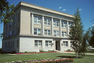
Steele County is a county in the U.S. state of North Dakota. As of the 2020 census, the population was 1,798, making it the fifth-least populous county in North Dakota. Its county seat since 1919 is Finley.
Richland County is a county in the far southeast corner of the U.S. state of North Dakota. As of the 2020 census, the population was 16,529. Its county seat is Wahpeton.
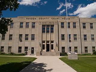
Ransom County is a county in the U.S. state of North Dakota. As of the 2020 census, the population was 5,703. Its county seat is Lisbon.
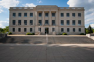
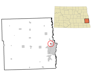
Cass County is a county in the U.S. state of North Dakota. As of the 2020 census, the population was 184,525. Cass County is the most populous county in North Dakota, accounting for nearly 24% of the state's population. The county seat is Fargo, the state's most populous city. The county is named for George Washington Cass, president of the Northern Pacific Railway from 1872 to 1875. It is the only Cass County in the United States that is not named after Lewis Cass.
Benson County is a county in the U.S. state of North Dakota. As of the 2020 census, the population was 5,964. Its county seat is Minnewaukan. The county was created on March 9, 1883 by the Dakota Territory legislature, and was named for Bertil W. Benson, a Dakota Territory legislator at the time. The county government was organized on June 4, 1884, and its boundary lines were altered by two legislative actions in 1885.
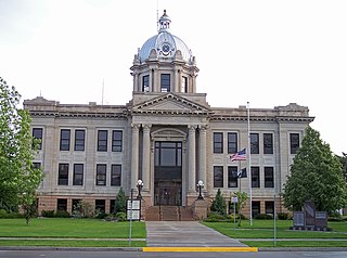
Barnes County is a county in the U.S. state of North Dakota. As of the 2020 census, the population was 10,853. Its county seat is Valley City.
Moorhead is a city in and the county seat of Clay County, Minnesota, United States, on the banks of the Red River of the North. Located in the Red River Valley, an extremely fertile and active agricultural region, Moorhead is also home to several corporations and manufacturing industries. Across the river from Fargo, North Dakota, Moorhead helps form the core of the Fargo–Moorhead ND-MN Metropolitan Area. The population was 44,505 at the 2020 census.
Eden Prairie is a city 12 miles (19 km) southwest of downtown Minneapolis in Hennepin County and the 16th-largest city in the State of Minnesota, United States. At the 2020 census, it had a population of 64,198. The city is adjacent to the north bank of the Minnesota River, upstream from its confluence with the Mississippi River.
Valley City is a city in and the county seat of Barnes County, North Dakota, United States. The population was 6,575 during the 2020 census, making it the 12th most populous city in North Dakota. Valley City was founded in 1874.
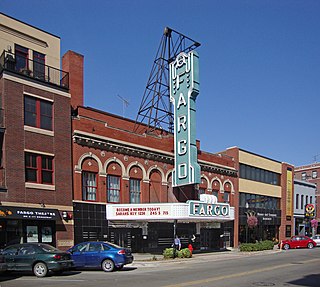
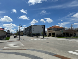
Fargo is a city in and the county seat of Cass County, North Dakota, United States. According to the 2020 census, its population was 125,990, making it the most populous city in the state and the 216th most populous city in the United States. Fargo, along with its twin city of Moorhead, Minnesota, and the adjacent cities of West Fargo, North Dakota and Dilworth, Minnesota, form the core of the Fargo–Moorhead, ND-MN Metropolitan Statistical Area (MSA). The MSA had a population of 248,591 in 2020.
Harwood is a city in Cass County, North Dakota, United States. The population was 794 at the 2020 census. It has become a bedroom community of the nearby Fargo-Moorhead area. Harwood was founded in 1881.
Horace is a city in Cass County, North Dakota, United States. As of the 2020 census, the population was 3,085.
Mapleton is a city in Cass County, North Dakota, United States. It sits on the banks of the Maple River. The population was 1,320 at the 2020 census. Mapleton serves as a bedroom community of the Fargo-Moorhead metropolitan area. The core cities are ten miles to the east of Mapleton.
Reile's Acres is a city in Cass County, North Dakota, United States. The population was 703 at the 2020 census. It is a suburb of Fargo. Reile's Acres was founded in 1977.
Sheyenne is a city in Eddy County, North Dakota, United States. The population was 186 at the 2020 census. Sheyenne was founded in 1883. A community center and the Log Cabin Museum are located on Main Street. On the east end of town there is a park with campsites located on Warsing Dam. Sheyenne is also home to two Lutheran churches: Grace Lutheran and First Lutheran.
Devils Lake is a city in and the county seat of Ramsey County, North Dakota, United States. The population was 7,192 at the 2020 census. It is named after the nearby body of water called Devils Lake. The first house built by an Euro-American settler was in 1882. It was surveyed in 1883 and named Creelsburg and later Creel City, after the surveyor, Heber M. Creel. In 1884 it was renamed Devils Lake.
Hillsboro is a small city in Traill County, North Dakota. It is the county seat of Traill County. The population was 1,649 at the 2020 census. Hillsboro was founded in 1881.
Osgood was a city in Cass County, North Dakota in the United States. The city was located on the east side of the Sheyenne River, three miles south of West Fargo. Osgood was founded in 1884 as "Garfield". The name was changed to "Osgood", in honor of the landowner who ceded the site to C.C. Furnberg, who located a country store and post office at the town site. The post office and country store ceased operations in 1953. Furnberg's son, Oscar, donated the store to the Cass County Historical Society, where it was restored and put on display at the Bonanzaville, USA pioneer village museum. Today, Osgood is no longer a city. Instead, the general vicinity of Osgood is now a neighborhood of Fargo, North Dakota, centered on a golf course. The course and neighborhood still bear the "Osgood" name. Many roads in the neighborhood, such as Fernberg Place and Houkum Court, were named after families who originally lived in the town. Pictures of the former town can be found in the Osgood Golf Course clubhouse and in the Osgood Hornbacher's supermarket.
Bonanzaville, USA is a history museum complex in West Fargo, North Dakota. Bonanzaville, the museum of the Cass County Historical Society, is made up of forty buildings on 12 acres (49,000 m2), many of them are historic and from the region. These buildings have been moved to the museum grounds and now form a village setting. Most of the buildings have a special theme. Displays include a prairie church, a general store, a drug store, a fire station, Fargo's first house, and a schoolhouse. There are also several newer buildings which have been constructed on the grounds including an aircraft museum and an automobile museum.
{{cite web}}
: CS1 maint: archived copy as title (link)