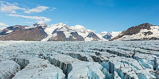
A glacier is a persistent body of dense ice that is constantly moving under its own weight. A glacier forms where the accumulation of snow exceeds its ablation over many years, often centuries. It acquires distinguishing features, such as crevasses and seracs, as it slowly flows and deforms under stresses induced by its weight. As it moves, it abrades rock and debris from its substrate to create landforms such as cirques, moraines, or fjords. Although a glacier may flow into a body of water, it forms only on land and is distinct from the much thinner sea ice and lake ice that form on the surface of bodies of water.
Jim Wickwire is the first American to summit K2, the second highest mountain in the world. Wickwire is also known for surviving an overnight solo bivouac on K2 at an elevation above 27,000 ft or 8,200 m; considered "one of the most notorious bivouacs in mountaineering history".

Glaciology is the scientific study of glaciers, or more generally ice and natural phenomena that involve ice.
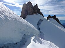
A crevasse is a deep crack, that forms in a glacier or ice sheet that can be a few inches across to over 40 feet. Crevasses form as a result of the movement and resulting stress associated with the shear stress generated when two semi-rigid pieces above a plastic substrate have different rates of movement. The resulting intensity of the shear stress causes a breakage along the faces.

An arête is a narrow ridge of rock that separates two valleys. It is typically formed when two glaciers erode parallel U-shaped valleys. Arêtes can also form when two glacial cirques erode headwards towards one another, although frequently this results in a saddle-shaped pass, called a col. The edge is then sharpened by freeze-thaw weathering, and the slope on either side of the arête steepened through mass wasting events and the erosion of exposed, unstable rock. The word arête is actually French for "edge" or "ridge"; similar features in the Alps are often described with the German equivalent term Grat.

A pyramidal peak, sometimes called a glacial horn in extreme cases, is an angular, sharply pointed mountain peak which results from the cirque erosion due to multiple glaciers diverging from a central point. Pyramidal peaks are often examples of nunataks.

The Jungfraujoch is a saddle connecting two major 4000ers of the Bernese Alps: the Jungfrau and the Mönch. It lies at an elevation of 3,463 metres (11,362 ft) above sea level and is directly overlooked by the rocky prominence of the Sphinx. The Jungfraujoch is a glacier saddle, on the upper snows of the Aletsch Glacier, and part of the Jungfrau-Aletsch area, situated on the boundary between the cantons of Bern and Valais, halfway between Interlaken and Fiesch.

A cirque is an amphitheatre-like valley formed by glacial erosion. Alternative names for this landform are corrie and cwm. A cirque may also be a similarly shaped landform arising from fluvial erosion.

An icefall is a portion of certain glaciers characterized by relatively rapid flow and chaotic crevassed surface, caused in part by gravity. The term icefall is formed by analogy with the word waterfall, which is a similar phenomenon of the liquid phase but at a more spectacular speed. When ice movement of a glacier is faster than elsewhere, because the glacier bed steepens or narrows, and the flow cannot be accommodated by plastic deformation, the ice fractures, forming crevasses. Where two fractures meet, seracs can be formed. When the movement of the ice slows down, the crevasses can coalesce, resulting in the surface of the glacier becoming smoother.

The Khumbu Icefall is located at the head of the Khumbu Glacier and the foot of the Western Cwm, which lies at an elevation of 5,486 metres (17,999 ft) on the Nepali slopes of Mount Everest, not far above Base Camp and southwest of the summit. The icefall is considered one of the most dangerous stages of the South Col route to Everest's summit.

A serac is a block or column of glacial ice, often formed by intersecting crevasses on a glacier. Commonly house-sized or larger, they are dangerous to mountaineers, since they may topple with little warning. Even when stabilized by persistent cold weather, they can be an impediment to glacier travel.

The Kangshung Face or East Face is the eastern-facing side of Mount Everest, one of the Tibetan sides of the mountain. It is 3,350 metres (11,000 ft) from its base on the Kangshung Glacier to the summit. It is a broad face, topped on the right by the upper Northeast Ridge, and on the left by the Southeast Ridge and the South Col. Most of the upper part of the face is composed of hanging glaciers, while the lower part consists of steep rock buttresses with couloirs between them. The steep southern third of the Kangshung Face also comprises the Northeastern Face of Lhotse; this section may be considered a separate face altogether following the division of the South "Neverest" Buttress up to the South Col. It is considered to be a dangerous route of ascent, compared to the standard North Col and South Col routes, and it is the most remote face of the mountain, with a longer approach.
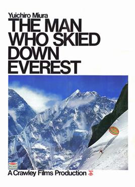
The Man Who Skied Down Everest is a Canadian documentary about Yuichiro Miura, a Japanese alpinist who skied down Mount Everest in 1970. The film was produced by Crawley Films' "Budge" Crawley and directed by Crawley and Bruce Nyznik.

A cirque glacier is formed in a cirque, a bowl-shaped depression on the side of or near mountains. Snow and ice accumulation in corries often occurs as the result of avalanching from higher surrounding slopes. If a cirque glacier advances far enough, it may become a valley glacier. Additionally, if a valley glacier retreats enough that it is within the cirque, it becomes a cirque glacier again.

The Coalman Glacier is a glacier located on the upper slopes of Mount Hood in the U.S. state of Oregon. It is the mountain's highest glacier ranging from about 11,200 to 10,500 ft, located within the crater rim, southwest of the peak. It was named for Elija Coalman, an early mountain guide who climbed Mount Hood 586 times.

The 1922 British Mount Everest expedition was the first mountaineering expedition with the express aim of making the first ascent of Mount Everest. This was also the first expedition that attempted to climb Everest using bottled oxygen. The expedition attempted to climb Everest from the northern side out of Tibet. At the time, Everest could not be attempted from the south out of Nepal as the country was closed to Western foreigners.

A randkluft or rimaye is the headwall gap between a glacier or snowfield and the adjacent rock face at the back of the cirque or, more loosely, between the rock face and the side of the glacier.

The 1933 British Mount Everest expedition was, after the reconnaissance expedition of 1921, and the 1922 and 1924 expeditions, the fourth British expedition to Mount Everest and the third with the intention of making the first ascent.

A glacier head is the top of a glacier. Although glaciers seem motionless to the observer they are in constant motion and the terminus is always either advancing or retreating.

The 1955 British Kangchenjunga expedition succeeded in climbing the 28,168-foot (8,586 m) Kangchenjunga, the third highest mountain in the world, for the first time. The expedition complied with a request from the Sikkim authorities that the summit should not be trodden on so the climbers deliberately stopped about five feet below the summit. George Band and Joe Brown reached the top on 25 May 1955, and they were followed the next day by Norman Hardie and Tony Streather. The expedition was led by Charles Evans who had been deputy leader on the 1953 British Mount Everest expedition.