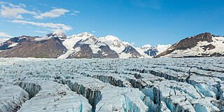
A glacier is a persistent body of dense ice that is constantly moving under its own weight. A glacier forms where the accumulation of snow exceeds its ablation over many years, often centuries. It acquires distinguishing features, such as crevasses and seracs, as it slowly flows and deforms under stresses induced by its weight. As it moves, it abrades rock and debris from its substrate to create landforms such as cirques, moraines, or fjords. Although a glacier may flow into a body of water, it forms only on land and is distinct from the much thinner sea ice and lake ice that form on the surface of bodies of water.

A moraine is any accumulation of unconsolidated debris, sometimes referred to as glacial till, that occurs in both currently and formerly glaciated regions, and that has been previously carried along by a glacier or ice sheet. It may consist of partly rounded particles ranging in size from boulders down to gravel and sand, in a groundmass of finely-divided clayey material sometimes called glacial flour. Lateral moraines are those formed at the side of the ice flow, and terminal moraines were formed at the foot, marking the maximum advance of the glacier. Other types of moraine include ground moraines and medial moraines.
Landforms are categorized by characteristic physical attributes such as their creating process, shape, elevation, slope, orientation, rock exposure, and soil type.
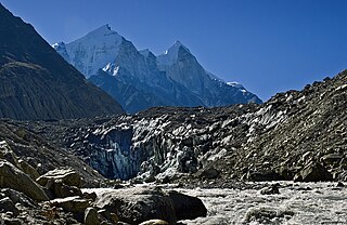
Gangotri is located in Uttarkashi District, Uttarakhand, India in a region bordering Tibet. This glacier, one of the primary sources of the Ganges, has a volume of over 27 cubic kilometers. The glacier is about 30 kilometres long and 2 to 4 km wide. Around the glacier are the peaks of the Gangotri Group, including several peaks notable for extremely challenging climbing routes, such as Shivling, Thalay Sagar, Meru, and Bhagirathi III. It flows roughly northwest, originating in a cirque below Chaukhamba, the highest peak of the group.
A crevasse is a deep crack that forms in a glacier or ice sheet. Crevasses form as a result of the movement and resulting stress associated with the shear stress generated when two semi-rigid pieces above a plastic substrate have different rates of movement. The resulting intensity of the shear stress causes a breakage along the faces.

A jökulhlaup is a type of glacial outburst flood. It is an Icelandic term that has been adopted in glaciological terminology in many languages. It originally referred to the well-known subglacial outburst floods from Vatnajökull, Iceland, which are triggered by geothermal heating and occasionally by a volcanic subglacial eruption, but it is now used to describe any large and abrupt release of water from a subglacial or proglacial lake/reservoir.

A kettle is a depression or hole in an outwash plain formed by retreating glaciers or draining floodwaters. The kettles are formed as a result of blocks of dead ice left behind by retreating glaciers, which become surrounded by sediment deposited by meltwater streams as there is increased friction. The ice becomes buried in the sediment and when the ice melts, a depression is left called a kettle hole, creating a dimpled appearance on the outwash plain. Lakes often fill these kettles; these are called kettle hole lakes. Another source is the sudden drainage of an ice-dammed lake and when the block melts, the hole it leaves behind is a kettle. As the ice melts, ramparts can form around the edge of the kettle hole. The lakes that fill these holes are seldom more than 10 m (33 ft) deep and eventually fill with sediment. In acid conditions, a kettle bog may form but in alkaline conditions, it will be kettle peatland.

Melt ponds are pools of open water that form on sea ice in the warmer months of spring and summer. The ponds are also found on glacial ice and ice shelves. Ponds of melted water can also develop under the ice, which may lead to the formation of thin underwater ice layers called false bottoms.
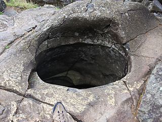
A giant's kettle, also known as either a giant's cauldron, moulin pothole, or glacial pothole, is a typically large and cylindrical pothole drilled in solid rock underlying a glacier either by water descending down a deep moulin or by gravel rotating in the bed of subglacial meltwater stream.
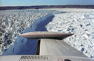
Jakobshavn Glacier, also known as Ilulissat Glacier, is a large outlet glacier in West Greenland. It is located near the Greenlandic town of Ilulissat and ends at the sea in the Ilulissat Icefjord.

A tunnel valley is a U-shaped valley originally cut under the glacial ice near the margin of continental ice sheets such as that now covering Antarctica and formerly covering portions of all continents during past glacial ages. They can be as long as 100 km (62 mi), 4 km (2.5 mi) wide, and 400 m (1,300 ft) deep.
Glacial surges are short-lived events where a glacier can advance substantially, moving at velocities up to 100 times faster than normal. Surging glaciers cluster around a few areas. High concentrations of surging glaciers occur in the Karakoram, Pamir Mountains, Svalbard, the Canadian Arctic islands, Alaska and Iceland, although overall it is estimated that only one percent of all the world's glaciers ever surge. In some glaciers, surges can occur in fairly regular cycles, with 15 to 100 or more surge events per year. In other glaciers, surging remains unpredictable. In some glaciers, however, the period of stagnation and build-up between two surges typically lasts 10 to 200 years and is called the quiescent phase. During this period the velocities of the glacier are significantly lower, and the glaciers can retreat substantially.

Glacier morphology, or the form a glacier takes, is influenced by temperature, precipitation, topography, and other factors. The goal of glacial morphology is to gain a better understanding of glaciated landscapes and the way they are shaped. Types of glaciers can range from massive ice sheets, such as the Greenland ice sheet, to small cirque glaciers found perched on mountain tops. Glaciers can be grouped into two main categories:

Meltwater is water released by the melting of snow or ice, including glacial ice, tabular icebergs and ice shelves over oceans. Meltwater is often found during early spring when snow packs and frozen rivers melt with rising temperatures, and in the ablation zone of glaciers where the rate of snow cover is reducing. Meltwater can be produced during volcanic eruptions, in a similar way in which the more dangerous lahars form. It can also be produced by the heat generated by the flow itself.

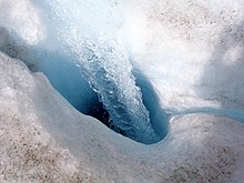
A supraglacial lake is any pond of liquid water on the top of a glacier. Although these pools are ephemeral, they may reach kilometers in diameter and be several meters deep. They may last for months or even decades at a time, but can empty in the course of hours.

Ice sheet dynamics describe the motion within large bodies of ice such as those currently on Greenland and Antarctica. Ice motion is dominated by the movement of glaciers, whose gravity-driven activity is controlled by two main variable factors: the temperature and the strength of their bases. A number of processes alter these two factors, resulting in cyclic surges of activity interspersed with longer periods of inactivity, on both hourly and centennial time scales. Ice-sheet dynamics are of interest in modelling future sea level rise.

Overdeepening is a characteristic of basins and valleys eroded by glaciers. An overdeepened valley profile is often eroded to depths which are hundreds of metres below the lowest continuous surface line along a valley or watercourse. This phenomenon is observed under modern day glaciers, in salt-water fjords and fresh-water lakes remaining after glaciers melt, as well as in tunnel valleys which are partially or totally filled with sediment. When the channel produced by a glacier is filled with debris, the subsurface geomorphic structure is found to be erosionally cut into bedrock and subsequently filled by sediments. These overdeepened cuts into bedrock structures can reach a depth of several hundred metres below the valley floor.
Subglacial streams are conduits of glacial meltwater that flow at the base of glaciers and ice caps. Meltwater from the glacial surface travels downward throughout the glacier, forming an englacial drainage system consisting of a network of passages that eventually reach the bedrock below, where they form subglacial streams. Subglacial streams form a system of tunnels and interlinked cavities and conduits, with water flowing under extreme pressures from the ice above; as a result, flow direction is determined by the pressure gradient from the ice and the topography of the bed rather than gravity. Subglacial streams form a dynamic system that is responsive to changing conditions, and the system can change significantly in response to seasonal variation in meltwater and temperature. Water from subglacial streams is routed towards the glacial terminus, where it exits the glacier. Discharge from subglacial streams can have a significant impact on local, and in some cases global, environmental and geological conditions. Sediments, nutrients, and organic matter contained in the meltwater can all influence downstream and marine conditions. Climate change may have a significant impact on subglacial stream systems, increasing the volume of meltwater entering subglacial drainage systems and influencing their hydrology.

A glacier stream is a channelized area that is formed by a glacier in which liquid water accumulates and flows. Glacial streams are also commonly referred to as "glacier stream" or/and "glacial meltwater stream". The movement of the water is influenced and directed by gravity and the melting of ice. The melting of ice forms different types of glacial streams such as supraglacial, englacial, subglacial and proglacial streams. Water enters supraglacial streams that sit at the top of the glacier via filtering through snow in the accumulation zone and forming slush pools at the FIRN zone. The water accumulates on top of the glacier in supraglacial lakes and into supraglacial stream channels. The meltwater then flows through various different streams either entering inside the glacier into englacial channels or under the glacier into subglacial channels. Finally, the water leaves the glacier through proglacial streams or lakes. Proglacial streams do not only act as the terminus point but can also receive meltwater. Glacial streams can play a significant role in energy exchange and in the transport of meltwater and sediment.
A meltwater channel is a channel cut into ice, bedrock or unconsolidated deposits by the flow of water derived from the melting of a glacier or ice-sheet. The channel may form on the surface of, within, beneath, along the margins of or downstream from the ice mass. Accordingly it would be referred to as supraglacial, englacial, subglacial, lateral or proglacial.