
Coffs Harbour, locally nicknamed Coffs, is a coastal city on the Mid North Coast of New South Wales, Australia, 540 km (340 mi) north of Sydney, and 390 km (240 mi) south of Brisbane. It is one of the largest urban centres on the North Coast, with a population of 78,759 as per 2021 census. The Gumbaynggirr are the original people of the Coffs Harbour region.
Sawtell is a suburb of the City of Coffs Harbour in northern New South Wales, Australia. It borders Toormina to the West.

Ulong is a small village located on the Mid North Coast region, neighbouring the Northern Tablelands, of New South Wales, Australia. It has a community hall, public school, cafe-post office and an Ex-services Club.

Forest Coach Lines is an Australian bus and coach operator. Founded in 1930 in the Northern Suburbs of Sydney, since 2016 it has expanded with purchases in the Mid North Coast and North West Slopes regions in New South Wales. It is a subsidiary of ComfortDelGro Australia.
Toormina is a suburb in the City of Coffs Harbour, on the east coast of New South Wales, Australia. Located in the city's south, Toormina is near the seaside suburb of Sawtell.
Bonville is a small town located on the Mid North Coast of New South Wales, Australia, 11 kilometres south of Coffs Harbour and in the local government area of City of Coffs Harbour. It has a population of 1,891 as of 2006. The town's name supposedly derives from "Bongol Bongol/Bongil Bongil", which in Gumbaingirr, means a place where one stays a long time.

The City of Coffs Harbour is a local government area in the mid north coast region of New South Wales, Australia. The area under administration is 1,175 square kilometres (454 sq mi), expanded in 2004 to take in parts of the former Pristine Waters local government area.

Mourilyan is a town and locality in the Cassowary Coast Region, Queensland, Australia. It was established around the Mourilyan sugar mill which provided much of the employment in the area until it was destroyed by Cyclone Larry on 20 March 2006. In the 2016 census, Mourilyan had a population of 571 people.
Raleigh is a small town in the Mid North Coast region of New South Wales, Australia, in Bellingen Shire. At the 2011 census, Raleigh had a population of 550. The town is south of Coffs Harbour and Sawtell and north of Nambucca Heads. It is located in Raleigh County and is perhaps named after it. It has one school, Raleigh Public School, which is located opposite a Norco dairy factory. A railway station on the North Coast line opened in 1915, but was subsequently closed and demolished.

Tullibigeal is a small farming community in the Central West region of New South Wales, Australia. It has a population of 233 in the 2016 census.
Lowanna is a village in the Coffs Harbour hinterland, officially a suburb of the City of Coffs Harbour. It has a Community Hall, Primary School, Preschool, Tennis Court and General Store. The name Lowanna is an Aboriginal language word meaning "girl". Lowanna had a train station on the now-closed Dorrigo railway line.
Racecourse is a suburb of Mackay in the Mackay Region, Queensland, Australia. In the 2021 census Racecourse had a population of 181 people.
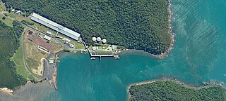
Mourilyan Harbour is a coastal locality and harbour within the Cassowary Coast Region, Queensland, Australia. In the 2021 census, Mourilyan Harbour had a population of 142 people.

Alexandra is a suburb of Mackay in the Mackay Region, Queensland, Australia. In the 2016 census, Alexandra had a population of 193 people.
Glenella is a mixed-use town and suburb of Mackay in the Mackay Region, Queensland, Australia. In the 2016 census, Glenella had a population of 4,519 people.
Richmond is a suburb of Mackay in the Mackay Region, Queensland, Australia. In the 2016 census Richmond had a population of 486 people.
Duingal is a locality in the Bundaberg Region, Queensland, Australia. In the 2021 census, Duingal had a population of 70 people.
Goolboo is a rural locality in the Cassowary Coast Region of Queensland, Australia. In the 2021 census, Goolboo had a population of 25 people.
Germantown is a rural locality in the Cassowary Coast Region, Queensland, Australia. In the 2021 census, Germantown had a population of 52 people.
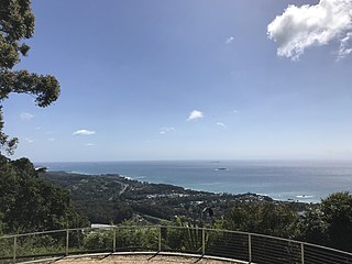
Korora is a suburb of the City of Coffs Harbour in New South Wales, Australia, located 6 km north of the city centre. Korora is located in a basin that runs from the foothills of the Great Dividing Range in the west to Korora Bay in the east. It is bisected by the Pacific Highway, which runs south to north between Sydney and Brisbane. The section of Korora between the Pacific Highway and the coast is mainly residential, with some tourist facilities. The section west of the Highway consists of larger residential blocks and farms growing mainly bananas and blueberries. The west-most section of Korora is forested and includes part of the Ulidarra National Park. The Korora basin is drained by creeks that flow into Pine Brush Creek and enter the sea at Hills Beach.

