City of Greater Taree

Last updated

Greater Taree
New South Wales
Greater taree LGA NSW.png
Location in New South Wales
Coordinates 31°54′S152°27′E / 31.900°S 152.450°E / -31.900; 152.450
Population46,541 (2011) [1]
 • Density12.48/km2 (32.3/sq mi)
Established1981
Abolished12 May 2016 (2016-05-12)
Area3,730 km2 (1,440.2 sq mi)
MayorPaul Hogan (Unaligned)
Council seat Taree
Region Mid North Coast
State electorate(s)
Federal division(s) Lyne
Website Greater Taree
LGAs around Greater Taree:
Walcha Port Macquarie-Hastings Tasman Sea
Gloucester Greater Taree Tasman Sea
Gloucester Great Lakes Tasman Sea

The Greater Taree City Council (GTCC) was a local government area on the Mid North Coast of New South Wales, Australia, until 12 May 2016 when it was amalgamated to form part of the Mid-Coast Council. It was originally formed in 1981 from the Manning Shire, and the Taree and Wingham Municipal Councils. The council was centred on Taree, located adjacent to the Manning River, the Pacific Highway and the North Coast railway line.

Contents

The last serving mayor of GTCC was Cr. Paul Hogan, an unaligned politician.

Towns and localities

Towns and localities included in the former GTCC were:

Demographics

At the last 2011 Census performed for the local government area, there were 46,541 people in the GTCC government area, of these 48.7% were male and 51.3% were female. Aboriginal and Torres Strait Islander people made up 5.4% of the population, double the national average. The median age of people in the City of Greater Taree was 46 years; some nine years higher than the national median. Children aged 0 – 14 years made up 18.6% of the population and people aged 65 years and over made up 22.5% of the population. Of people in the area aged 15 years and over, 50.0% were married and 14.8% were either divorced or separated. [1]

Population growth in the GTCC between the 2001 Census and the 2006 Census has been 5.39%; and in the subsequent five years was 3.09%. When compared with total population growth of Australia for the same periods, being 5.78% and 8.32% respectively, population growth in the GTCC local government area was significantly lower than the national average. [2] The median weekly income for residents within the GTCC was significantly below the national average, [1] [3] being one of the factors that place the GTCC in an area of social disadvantage.

At the 2011 Census, the last to be performed for the former council, the proportion of residents in the local government area who stated their ancestry as Australian or Anglo-Saxon exceeded 83% of all residents (national average was 65.2%). In excess of 62% of all residents in the GTCC had nominated a religious affiliation with Christianity at the 2011 Census, which was higher than the national average of 50.2%. Meanwhile, as at the Census date, compared to the national average, households in the GTCC government area had a significantly lower than average proportion (3.4%) where two or more languages are spoken (national average was 20.4%); and a significantly higher proportion (93.3%) where English only was spoken at home (national average was 76.8%). [1]

Selected historical census data for Greater Taree local government area
Census year2001 [2] 2006 [3] 2011 [1]
PopulationEstimated residents on Census night42,83845,14546,541
LGA rank in terms of size within New South Wales
% of New South Wales population0.67%
% of Australian population0.23%Steady2.svg 0.23%Decrease2.svg 0.22%
Cultural and language diversity
Ancestry,
top responses
Australian 34.3%
English 33.1%
Irish 8.0%
Scottish 7.6%
German 2.9%
Language,
top responses
(other than English)
German 0.2%Steady2.svg 0.2%Increase2.svg 0.3%
Italian 0.2%Decrease2.svg 0.1%Steady2.svg 0.1%
Dutch 0.2%Steady2.svg 0.2%Decrease2.svg 0.1%
Cantonese 0.1%Increase2.svg 0.2%Decrease2.svg 0.1%
French n/cn/cIncrease2.svg 0.1%
Religious affiliation
Religious affiliation,
top responses
Anglican 34.9%Decrease2.svg 33.3%Decrease2.svg 32.3%
Catholic 20.0%Increase2.svg 20.1%Decrease2.svg 19.2%
No Religion 11.5%Increase2.svg 14.8%Increase2.svg 18.4%
Uniting Church 8.7%Decrease2.svg 7.5%Decrease2.svg 6.8%
Presbyterian and Reformed 5.1%Decrease2.svg 4.7%Decrease2.svg 4.4%
Median weekly incomes
Personal incomeMedian weekly personal incomeA$336A$395
% of Australian median income72.1%68.5%
Family incomeMedian weekly family incomeA$635A$930
% of Australian median income61.8%62.8%
Household incomeMedian weekly household incomeA$798A$770
% of Australian median income68.1%62.4%

Council

Previous composition and election method

GTCC was last formed with nine councillors, including the mayor, for a fixed four-year term of office. The mayor was directly elected while eight other councillors were elected proportionally as one entire ward. The last election was held on 8 September 2012, and the makeup of the council when it was amalgamated into the Mid-Coast Council, including the mayor, was as follows: [4] [5]

PartyCouncillors
  Independents and Unaligned9
Total9

The current Council, elected in 2012, in order of election, is: [5]

CouncillorPartyNotes
 Paul Hogan Unaligned Mayor [4]
 Trent JennisonUnalignedElected on Paul Hogan's ticket
 Peter Epov Independent
 Kathryn BellIndependent
 Alan TickleUnaligned
 David KeeganIndependent
 Brad ChristensenIndependent
 David WestUnaligned
 Robyn JenkinsUnaligned

History

The first movement to establish the GTCC began in November 1959. The Taree Municipal Council applied to the Department of Local Government to extend its boundaries to the coastal area between Old Bar and Seal Rocks. [6]

At an inquiry of the Boundaries Commission at Taree in 1976, the Dungog Shire proposed that the areas covered by the shires of Dungog, Gloucester, Great Lakes and Manning and the municipalities of Taree and Wingham be combined into two areas "to elevate local government to its proper role". At this stage, Taree Municipal Council proposed only their merger with the Municipality of Wingham. A decision was postponed for five years. [6] Due to the town of Taree not having a town hall, the Taree Municipal Council could not be renamed to The Greater Taree City Council as planned. However, by merging the Municipality of Taree and Municipality of Wingham together so that Taree could claim the town hall in Wingham as they own, only then could the formation of the Greater Taree City Council be formed.

On 1 January 1981, the City of Greater Taree was proclaimed, encompassing the Municipalities of Taree and Wingham and the Manning Valley Shire. [6] [7]

A 2015 review of local government boundaries by the NSW Government Independent Pricing and Regulatory Tribunal had recommended the merger of a number of adjoining councils. In the initial proposal, the City of Greater Taree was not included in any amalgamation proposals. The amalgamation of the Gloucester, Great Lakes and Greater Taree councils was proclaimed on 12 May 2016, and followed the submission for such an amalgamation by Gloucester Shire Council. [8]

Related Research Articles

<span class="mw-page-title-main">Taree</span> Town in New South Wales, Australia

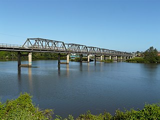
Taree is a town on the Mid North Coast, New South Wales, Australia. Taree and nearby Cundletown were settled in 1831 by William Wynter. Since then Taree has grown to a population of 26,381, and is the centre of a significant agricultural district. Situated on a floodplain by the Manning River, it is 16 km from the Tasman Sea coast, and 317 km north of Sydney.

<span class="mw-page-title-main">City of Kogarah</span> Former local government area in New South Wales, Australia

The City of Kogarah was a local government area in the St George region of southern Sydney, in the state of New South Wales, Australia. The centre of the city is located 14 kilometres (8.7 mi) south-west of the Sydney central business district and west of Botany Bay.

<span class="mw-page-title-main">City of Hawkesbury</span> Local government area in New South Wales, Australia

The City of Hawkesbury is a local government area of New South Wales, Australia, the City of Hawkesbury is located on the North and North Western edge of the Greater Sydney region and is adjacent to the Sydney metropolitan area, about 50 kilometres (31 mi) north-west of the Sydney central business district. Hawkesbury City is named after the Hawkesbury River.

<span class="mw-page-title-main">Wingham, New South Wales</span> Town in New South Wales, Australia

Wingham is a town in the Mid North Coast region of New South Wales, Australia in the Mid-Coast Council area 329 kilometres (204 mi) north of Sydney. According to the 2021 census, Wingham had a population of 5,395.

<span class="mw-page-title-main">Gwydir Shire</span> Local government area in New South Wales, Australia

Gwydir Shire is a local government area located in the New England region of New South Wales, Australia. The northern boundary of the Shire is located adjacent to the border between New South Wales and Queensland.

<span class="mw-page-title-main">City of Parramatta</span> Local government area in New South Wales, Australia

The City of Parramatta, also known as Parramatta Council, is a local government area located west of central Sydney in the Greater Western Sydney region. Parramatta Council is situated between the City of Ryde and Cumberland, where the Cumberland Plain meets the Hornsby Plateau, approximately 25 kilometres (16 mi) west of the Sydney central business district, in New South Wales, Australia. The city occupies an area of 84 square kilometres (32 sq mi) spanning across suburbs in Greater Western Sydney including the Hills District, and a small section of Northern Sydney to the far north east of its area. According to the 2016 census, City of Parramatta had an estimated population of 226,149. The city houses the Parramatta central business district which is one of the key suburban employment destinations for the region of Greater Western Sydney.

<span class="mw-page-title-main">City of Wollongong</span> Local government area in New South Wales, Australia

The City of Wollongong is a local government area in the Illawarra region of New South Wales, Australia. The area is situated adjacent to the Tasman Sea, the Princes Motorway and the Illawarra railway line.

<span class="mw-page-title-main">Port Stephens Council</span> Local government area in New South Wales, Australia

Port Stephens Council is a local government area in the Hunter Region of New South Wales, Australia. The area is just north of Newcastle and is adjacent to the Pacific Highway which runs through Raymond Terrace, the largest town and Council seat. The area is named after Port Stephens, which is the major geographical feature of the area. It extends generally from the Hunter River in the south, to near Clarence Town in the north, and from the Tasman Sea in the east, to just south of Paterson in the west. The mayor of Port Stephens Council is Ryan Palmer. Palmer was caught in a major scandal in 2022 following the purchase of an $86,000 Ford Ranger for mayoral and personal use. Port Stephens is about two and a half hours north of Sydney.

<span class="mw-page-title-main">Great Lakes Council</span> Former local government area in New South Wales, Australia

Great Lakes Council was a local government area in the Mid North Coast region of New South Wales, Australia. The area is situated adjacent to the shores of Port Stephens, Myall Lakes and Wallis Lake and the Pacific Highway and the Lakes Way. On 12 May 2016 the council was dissolved and the area included in the Mid-Coast Council, along with the City of Greater Taree and Gloucester Shire.

<span class="mw-page-title-main">Gloucester Shire</span> Former local government area in New South Wales, Australia

Gloucester Shire was a local government area in the Mid North Coast and Upper Hunter regions of New South Wales, Australia. The Shire was situated adjacent to the Bucketts Way and the North Coast railway line.

<span class="mw-page-title-main">Narrabri Shire</span> Local government area in New South Wales, Australia

Narrabri Shire is a local government area in the North West Slopes region of New South Wales, Australia. The Shire is located adjacent to the Namoi River and the Newell and Kamilaroi Highways.

<span class="mw-page-title-main">City of Maitland</span> Local government area in New South Wales, Australia

The City of Maitland is a local government area in the lower Hunter region of New South Wales, Australia. The area is situated adjacent to the New England Highway and the Hunter railway line.

<span class="mw-page-title-main">City of Newcastle</span> Local government area in New South Wales, Australia

The City of Newcastle is a local government area in the Hunter region of New South Wales, Australia. The City of Newcastle incorporates much of the area of the Newcastle metropolitan area.

<span class="mw-page-title-main">City of Wagga Wagga</span> Local government area in New South Wales, Australia

City of Wagga Wagga is a local government area in the Riverina region of southern New South Wales, Australia.

<span class="mw-page-title-main">Dungog Shire</span> Local government area in New South Wales, Australia

Dungog Shire is a local government area in the Hunter region of New South Wales, Australia. The Shire is situated adjacent to the Barrington Tops and consists predominantly of very rugged to hilly country which becomes less rugged from north to south.

<span class="mw-page-title-main">Georges River Council</span> Local government area in New South Wales, Australia

Georges River Council is a local government area located in the St George region of Sydney located south of the CBD, in New South Wales, Australia. The Council was formed on 12 May 2016 from the merger of the Hurstville City Council and Kogarah City Council.

<span class="mw-page-title-main">MidCoast Council</span> Local government area in New South Wales, Australia

MidCoast Council is a local government area (LGA) located in the Mid North Coast region of New South Wales, Australia. The council was formed on 12 May 2016 through a merger of the Gloucester Shire, Great Lakes and City of Greater Taree councils.

<span class="mw-page-title-main">Bayside Council</span> Local government area in New South Wales, Australia

Bayside Council is a southern local government area in New South Wales, Australia. It is located in Sydney, around part of Botany Bay, 7 kilometres (4.3 mi) to 12 kilometres (7.5 mi) south of the CBD. It includes suburbs of Southern Sydney and the St George area separated by the Cooks River as well as a small portion in the Eastern suburbs, south-east of the CBD. It comprises an area of 50 square kilometres (19 sq mi) and as at the 2016 census had a population of 156,058.

<span class="mw-page-title-main">Wingham Memorial Town Hall</span> Historic site in New South Wales, Australia

Wingham Memorial Town Hall is a heritage-listed town hall at 52 Farquhar Street, Wingham, Mid-Coast Council, New South Wales, Australia. It was designed by James T. Chambers and built from 1922 to 1924. It is also known as Wingham Town Hall and Wingham Council Chambers. The property is owned by Mid-Coast Council. It was added to the New South Wales State Heritage Register on 8 April 2016.

Manning Shire was a local government area in the Mid North Coast region of New South Wales, Australia.

References

  1. 1 2 3 4 5 Australian Bureau of Statistics (31 October 2012). "Greater Taree (C)". 2011 Census QuickStats. Retrieved 30 November 2012. OOjs UI icon edit-ltr-progressive.svg
  2. 1 2 Australian Bureau of Statistics (9 March 2006). "Greater Taree (C)". 2001 Census QuickStats. Retrieved 30 November 2012. OOjs UI icon edit-ltr-progressive.svg
  3. 1 2 Australian Bureau of Statistics (25 October 2007). "Greater Taree (C)". 2006 Census QuickStats. Retrieved 30 November 2012.
  4. 1 2 "Greater Taree City Council - Mayoral Election". Local Government Elections 2012. Electoral Commission of New South Wales. 15 September 2012. Retrieved 28 September 2012.
  5. 1 2 "Greater Taree City Council – Summary of First Preference and Group Votes for each Candidate". Local Government Elections 2012. Electoral Commission of New South Wales. 16 September 2012. Retrieved 28 September 2012.
  6. 1 2 3 Ramsland, John (1987). The Struggle Against Isolation – A History of the Manning Valley. North Sydney, New South Wales: Library of Australian History. pp. 300–301. ISBN   0-908120-67-2.
  7. "Taree". The Age . 16 August 2007. Retrieved 7 October 2008.
  8. Toole, Paul (March 2016). "Dungog and Maitland councils Proposal" (PDF). Minister for Local Government. Government of New South Wales . Retrieved 8 March 2016.