Bontoc, Mountain Province

Last updated

Bontoc
Municipality of Bontoc
Bontoc top view from terraces (Bontoc, Mountain Province; 11-30-2022).jpg
Bontoc in 2022
Flag of Bontoc, Mountain Province.png
Bontoc Mountain Province.png
Ph locator mountain province bontoc.png
Map of Mountain Province with Bontoc highlighted
OpenStreetMap
Bontoc, Mountain Province
Philippines location map (square).svg
Red pog.svg
Bontoc
Location within the Philippines
Coordinates: 17°05′24″N120°58′38″E / 17.09°N 120.9772°E / 17.09; 120.9772
Country Philippines
Region Cordillera Administrative Region
Province Mountain Province
District Lone district
Founded 1908
Barangays 16 (see Barangays)
Government
[1]
  Type Sangguniang Bayan
   Mayor Jerome B. Tudlong, Jr.
   Vice Mayor Eusebio S. Kabluyen
   Representative Maximo Y. Dalog Jr.
   Municipal Council
Members
   Electorate 17,135 voters (2022)
Area
[3]
  Total396.10 km2 (152.94 sq mi)
Elevation
1,173 m (3,848 ft)
Highest elevation
1,833 m (6,014 ft)
Lowest elevation
804 m (2,638 ft)
Population
 (2020 census) [4]
  Total24,104
  Density61/km2 (160/sq mi)
   Households
6,452
Economy
   Income class 2nd municipal income class
   Poverty incidence
10.01
% (2018) [5]
   Revenue 193.7 million (2020)
   Assets 380.3 million (2020)
   Expenditure 147.8 million (2020)
   Liabilities 159.8 million (2020)
Service provider
   Electricity Mountain Province Electric Cooperative (MOPRECO)
Time zone UTC+8 (PST)
ZIP code
2616
PSGC
IDD : area code +63(0)74
Native languages Balangao
Bontoc
Ilocano
Tagalog
Website lgubontoc.gov.ph

Bontoc, officially the Municipality of Bontoc (Ilocano : Ili ti Bontoc; Tagalog : Bayan ng Bontoc), is a 2nd class municipality and capital of the province of Mountain Province, Philippines. According to the 2020 census, it has a population of 24,104 people. [4]

Contents

Bontoc is 392 kilometres (244 mi) from Manila.

Bontoc is the historical capital of the entire Cordillera region since the inception of governance in the Cordillera. The municipality celebrates the annual Lang-ay Festival. [6]

Bontoc is home to the Indigenous Bontoc people. The town also hosts the UNESCO tentatively-listed Alab petroglyphs.

History

Aerial view of Bontoc, 1933 Philippine Island - Bontoc - NARA - 68155882.jpg
Aerial view of Bontoc, 1933

Samuel E. Kane, the American supervisor and then Governor, established the capital here after the Philippine Commission passed the Mountain Province Act in 1908, [7] building a provincial building, hospital, doctor's office, nurse's home, a school, and provincial prison. [8] :281–284 He also built the Tagudin-Bontoc trail, which by 1926, could accommodate a small car. [8] :329

Bontoc was one of several municipalities in Mountain Province which would have been flooded by the Chico River Dam Project during the Marcos dictatorship, alongside Bauko, Sabangan, Sagada, Sadanga, and parts of Barlig. [9] However, the indigenous peoples of Kalinga Province and Mountain Province resisted the project and when hostilities resulted in the murder of Macli-ing Dulag, the project became unpopular and was abandoned before Marcos was ousted by the 1986 People Power Revolution. [10]

Cityhood

In the 19th Congress of the Philippines, house bills were filed by various representatives which seeks Bontoc including other capital towns of provinces with no current component cities, independent component cities or highly urbanized cities to automatically convert into cities. [11] [12] [13]

Geography

Barangays

Bontoc is politically subdivided into 16 barangays. Each barangay consists of puroks and some have sitios.

  • Alab Oriente
  • Alab Proper
  • Balili
  • Bay-yo
  • Bontoc Ili
  • Caluttit
  • Can-eo
  • Dalican
  • Gonogon
  • Guinaang
  • Mainit
  • Maligcong
  • Poblacion (Bontoc)
  • Samoki
  • Talubin
  • Tocucan

Climate

Climate data for Bontoc, Mountain Province
MonthJanFebMarAprMayJunJulAugSepOctNovDecYear
Mean daily maximum °C (°F)23
(73)
24
(75)
25
(77)
27
(81)
27
(81)
26
(79)
25
(77)
25
(77)
25
(77)
25
(77)
24
(75)
23
(73)
25
(77)
Mean daily minimum °C (°F)16
(61)
16
(61)
17
(63)
19
(66)
20
(68)
21
(70)
21
(70)
21
(70)
20
(68)
19
(66)
18
(64)
17
(63)
19
(66)
Average precipitation mm (inches)35
(1.4)
46
(1.8)
63
(2.5)
117
(4.6)
402
(15.8)
400
(15.7)
441
(17.4)
471
(18.5)
440
(17.3)
258
(10.2)
94
(3.7)
68
(2.7)
2,835
(111.6)
Average rainy days9.99.513.918.926.027.328.928.526.119.714.512.8236
Source: Meteoblue (modeled/calculated data, not measured locally) [14]

Demographics

Population census of Bontoc
YearPop.±% p.a.
1918 13,948    
1939 14,284+0.11%
1948 15,005+0.55%
1960 16,301+0.69%
1970 16,901+0.36%
YearPop.±% p.a.
1975 17,476+0.67%
1980 17,091−0.44%
1990 17,716+0.36%
1995 21,192+3.41%
2000 22,308+1.11%
YearPop.±% p.a.
2007 24,798+1.47%
2010 23,980−1.21%
2015 24,643+0.52%
2020 24,104−0.43%
Source: Philippine Statistics Authority [15] [16] [17] [18]

Most inhabitants speak the Bontoc language, with other major languages being Kankana-ey and Ilocano. Minor languages spoken include Tagalog, Pangasinan, Cuyonon and Butuanon. [19]

Economy

Maligcong Rice terraces of Bontoc. Maligcong Rice Terraces Image 2.jpg
Maligcong Rice terraces of Bontoc.

The local economy depends largely on small trades and agriculture. This capital town's biggest economic potential is tourism with its smaller rice terraces in Barangay Bay-yo, Maligcong and other areas. [27]

Government

Local government

Bontoc, belonging to the lone congressional district of the province of Mountain Province, is governed by a mayor designated as its local chief executive and by a municipal council as its legislative body in accordance with the Local Government Code. The mayor, vice mayor, and the councilors are elected directly by the people through an election which is being held every three years.

Elected officials

Members of the Municipal Council (2019–2022): [28]

Culture

Bontoc woman with snake skeletton.JPG
University of California publications in American archaeology and ethnology (1903) (14579727919).jpg
Bontoc woman with a snake skeleton in hair (a charm against lightning) and Bontoc man, c. 1903, (right)
Bontoc Museum Bontoc Museum (Poblacion, Bontoc, Mountain Province; 11-30-2022).jpg
Bontoc Museum

The highland town of Bontoc is home to two National Cultural Treasures of the Philippines. These are the Stone Agricultural Calendar of Bontoc and Petroglyphs of Alab. [29]

The Alab petroglyphs are ancient figures carved on mountain walls by the prehistoric people of Bontoc. [30] The petroglyphs are the most important ancient rock art carvings in the Cordilleras and the second oldest in the entire country, second only to the Angono petroglyphs of Rizal. Due to its high significance, it was submitted by the National Commission for Culture and the Arts of the Philippines to the UNESCO Tentative List of Heritage Sites in 2006, pending its inclusion in the World Heritage List along with the Singanapan charcoal-drawn petrographs of southern Palawan, Angono petroglyphs of Rizal province, charcoal-drawn Peñablanca petrographs of Cagayan, and the Anda red hermatite print petrographs of Bohol.

Education

Secondary education

Tertiary education

Mountain Province State Polytechnic College is the first tertiary institution in the municipality that offers various undergraduate and graduate courses.

XiJen College of Mountain Province is the only private tertiary institution that also offers technical-vocational courses.

Notable People

Related Research Articles

<span class="mw-page-title-main">Mountain Province</span> Province in Cordillera, Philippines

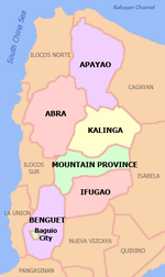
Mountain Province is a landlocked province of the Philippines in the Cordillera Administrative Region in Luzon. Its capital is Bontoc. Mountain Province was formerly referred to as Mountain in some foreign references. The name is usually shortened by locals to Mt. Province.

<span class="mw-page-title-main">Kalinga (province)</span> Province in Cordillera, Philippines

Kalinga, officially the Province of Kalinga, is a landlocked province in the Philippines situated within the Cordillera Administrative Region in Luzon. Its capital is Tabuk and borders Mountain Province to the south, Abra to the west, Isabela to the east, Cagayan to the northeast, and Apayao to the north. Kalinga and Apayao are the result of the 1995 partitioning of the former province of Kalinga-Apayao which was seen to better service the respective needs of the various indigenous peoples in the area.

<span class="mw-page-title-main">Bauko</span> Municipality in Mountain Province, Philippines

Bauko, officially the Municipality of Bauko is a 4th class municipality in the province of Mountain Province, Philippines. According to the 2020 census, it has a population of 32,021 people.

<span class="mw-page-title-main">Langiden</span> Municipality in Abra, Philippines

Langiden, officially the Municipality of Langiden, is a 5th class municipality in the province of Abra, Philippines. According to the 2020 census, it has a population of 3,576 people.

<span class="mw-page-title-main">San Isidro, Abra</span> Municipality in Abra, Philippines

San Isidro, officially the Municipality of San Isidro, is a 5th class municipality in the province of Abra, Philippines. According to the 2020 census, it has a population of 4,745 people.

<span class="mw-page-title-main">Peñablanca</span> Municipality in Cagayan, Philippines

Peñablanca, officially the Municipality of Peñablanca, is a 1st class municipality in the province of Cagayan, Philippines. According to the 2020 census, it has a population of 50,300 people.

<span class="mw-page-title-main">Anda, Bohol</span> Municipality in Bohol, Philippines

Anda, officially the Municipality of Anda, is a 3rd class municipality in the province of Bohol, Philippines. According to the 2020 census, it has a population of 17,778 people.

<span class="mw-page-title-main">Barlig</span> Municipality in Mountain Province, Philippines

Barlig, officially the Municipality of Barlig is a 5th class municipality in the province of Mountain Province, Philippines. According to the 2020 census, it has a population of 4,796 people.

<span class="mw-page-title-main">Besao</span> Municipality in Mountain Province, Philippines

Besao, officially the Municipality of Besao is a 5th class municipality in the province of Mountain Province, Philippines. According to the 2020 census, it has a population of 6,873 people..

<span class="mw-page-title-main">Paracelis</span> Municipality in Mountain Province, Philippines

Paracelis, officially the Municipality of Paracelis is a 2nd class municipality in the province of Mountain Province, Philippines. According to the 2020 census, it has a population of 31,168 people.

<span class="mw-page-title-main">Sabangan</span> Municipality in Mountain Province, Philippines

Sabangan, officially the Municipality of Sabangan is a 5th class municipality in the province of Mountain Province, Philippines. According to the 2020 census, it has a population of 9,621 people.

<span class="mw-page-title-main">Sadanga</span> Municipality in Mountain Province, Philippines

Sadanga, officially the Municipality of Sadanga is a 5th class municipality in the province of Mountain Province, Philippines. According to the 2020 census, it has a population of 8,427 people.

<span class="mw-page-title-main">Tadian</span> Municipality in Mountain Province, Philippines

Tadian, officially the Municipality of Tadian is a 4th class municipality in the province of Mountain Province, Philippines. According to the 2020 census, it has a population of 19,341 people.

<span class="mw-page-title-main">Kabugao</span> Capital of Apayao, Philippines

Kabugao, officially the Municipality of Kabugao, is a 1st class municipality and de jure capital of the province of Apayao, Philippines. According to the 2020 census, it has a population of 16,215 people.

<span class="mw-page-title-main">Tabuk, Kalinga</span> Capital of Kalinga, Philippines

Tabuk, officially the City of Tabuk, is a 5th class component city and capital of the province of Kalinga, Philippines. According to the 2020 census, it has a population of 121,033 people.

<span class="mw-page-title-main">Kapangan</span> Municipality in Benguet, Philippines

Kapangan, officially the Municipality of Kapangan,, is a 4th class municipality in the province of Benguet, Philippines. According to the 2020 census, it has a population of 19,297 people.

<span class="mw-page-title-main">Alfonso Lista</span> Municipality in Ifugao, Philippines

Alfonso Lista, formerly known as Potia, officially the Municipality of Lista is a 3rd class municipality in the province of Ifugao, Philippines. According to the 2020 census, it has a population of 34,061 people.

<span class="mw-page-title-main">Banaue</span> Municipality in Ifugao, Philippines

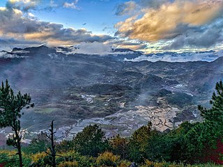
Banaue, officially the Municipality of Banaue is a 4th class municipality in the province of Ifugao, Philippines. According to the 2020 census, it has a population of 20,652 people.

<span class="mw-page-title-main">Lagawe</span> Capital of Ifugao, Philippines

Lagawe, officially the Municipality of Lagawe is a 4th class municipality and capital of the province of Ifugao, Philippines. According to the 2020 census, it has a population of 18,876 people.

<span class="mw-page-title-main">Rizal, Palawan</span> Municipality in Palawan, Philippines

Rizal, officially the Municipality of Jose P. Rizal,, is a 1st class municipality in the province of Palawan, Philippines. According to the 2020 census, it has a population of 56,162 people.

References

  1. Municipality of Bontoc | (DILG)
  2. "2019 Election Results:Bontoc, Mountain Province". GMA News. Retrieved October 7, 2021.
  3. "2015 Census of Population, Report No. 3 – Population, Land Area, and Population Density" (PDF). Philippine Statistics Authority. Quezon City, Philippines. August 2016. ISSN   0117-1453. Archived (PDF) from the original on May 25, 2021. Retrieved July 16, 2021.
  4. 1 2 Census of Population (2020). "Cordillera Administrative Region (CAR)". Total Population by Province, City, Municipality and Barangay. Philippine Statistics Authority . Retrieved July 8, 2021.
  5. "PSA Releases the 2018 Municipal and City Level Poverty Estimates". Philippine Statistics Authority. December 15, 2021. Retrieved January 22, 2022.
  6. Malingan, Jamie Joie (April 12, 2018). "Feature: Lang-Ay Festival: Celebrating a Culture of Sharing". Philippine Information Agency. Archived from the original on February 22, 2019. Retrieved February 22, 2019.
  7. "Act No. 1876". PhilippineLaw.info. August 18, 1908. Archived from the original on October 15, 2014. Retrieved October 22, 2014.
  8. 1 2 Kane, S.E., 1933, Thirty Years with the Philippine Head-Hunters, New York: Grosset & Dunlap
  9. "Valley of Sorrow". Asiaweek. September 5, 1980.
  10. Doyo, Ma. Ceres P. (2015). Macli-ing Dulag: Kalinga Chief, Defender of the Cordillera. Diliman, Quezon City: University of the Philippines Press. ISBN   978971542772-2.
  11. Yap, Eric (June 30, 2022). "AN ACT AUTOMATICALLY CONVERTING THE CAPITAL TOWN OF PROVINCES WITH NO COMPONENT CITIES, INDEPENDENT COMPONENT CITIES OR HIGHLY URBANIZED CITIES WITHIN ITS TERRITORIAL JURISDICTION, INTO A COMPONENT CITY" (PDF). House of Representatives of the Philippines. Retrieved April 1, 2023.
  12. Palma, Wilter (August 9, 2022). "AN ACT AUTOMATICALLY CONVERTING THE CAPITAL TOWN OF PROVINCES WITH NO COMPONENT CITIES, INDEPENDENT COMPONENT CITIES, OR HIGHLY URBANIZED CITIES WITHIN ITS TERRITORIAL JURISDICTION, INTO A COMPONENT CITY" (PDF). House of Representatives of the Philippines. Retrieved April 1, 2023.
  13. Daza, Paul (August 11, 2022). "AN ACT CONVERING INTO COMPONENT CITIES THE CAPITAL TOWNS OF PROVINCES WITHOUT A CITY, AMENDING FOR THE PURPOSE SECTION 450 OF REPUBLIC ACT NO. 7610, AS AMENDED BY REPUBLIC ACT NO. 9009, OTHERWISE KNOWN AS THE LOCAL GOVERNMENT CODE OF 1991, AND FOR OTHER PURPOSES" (PDF). House of Representatives of the Philippines. Retrieved April 1, 2023.
  14. "Bontoc: Average Temperatures and Rainfall". Meteoblue. Retrieved March 8, 2020.
  15. Census of Population (2015). "Cordillera Administrative Region (CAR)". Total Population by Province, City, Municipality and Barangay. Philippine Statistics Authority . Retrieved June 20, 2016.
  16. Census of Population and Housing (2010). "Cordillera Administrative Region (CAR)" (PDF). Total Population by Province, City, Municipality and Barangay. National Statistics Office . Retrieved June 29, 2016.
  17. Censuses of Population (1903–2007). "Cordillera Administrative Region (CAR)". Table 1. Population Enumerated in Various Censuses by Province/Highly Urbanized City: 1903 to 2007. National Statistics Office.{{cite encyclopedia}}: CS1 maint: numeric names: authors list (link)
  18. "Province of Mountain Province". Municipality Population Data. Local Water Utilities Administration Research Division. Retrieved December 17, 2016.
  19. "Annual Report; Local Government of Bontoc; CY 2011" (PDF). Local Government of Bontoc. 2011. Retrieved February 22, 2019.
  20. "Poverty incidence (PI):". Philippine Statistics Authority. Retrieved December 28, 2020.
  21. "Estimation of Local Poverty in the Philippines" (PDF). Philippine Statistics Authority. November 29, 2005.
  22. "2003 City and Municipal Level Poverty Estimates" (PDF). Philippine Statistics Authority. March 23, 2009.
  23. "City and Municipal Level Poverty Estimates; 2006 and 2009" (PDF). Philippine Statistics Authority. August 3, 2012.
  24. "2012 Municipal and City Level Poverty Estimates" (PDF). Philippine Statistics Authority. May 31, 2016.
  25. "Municipal and City Level Small Area Poverty Estimates; 2009, 2012 and 2015". Philippine Statistics Authority. July 10, 2019.
  26. "PSA Releases the 2018 Municipal and City Level Poverty Estimates". Philippine Statistics Authority. December 15, 2021. Retrieved January 22, 2022.
  27. "Mt. Province Travel Information". Asia Travel. Archived from the original on May 7, 2001. Retrieved February 22, 2019.
  28. "2019 National and Local Elections" (PDF). Commission on Elections. Retrieved March 13, 2022.
  29. "Presidential Decree No. 260, s. 1973;". Official Gazette of the Republic of the Philippines. August 1973. Archived from the original on June 19, 2018. Retrieved February 22, 2019.
  30. "Annual Report 2010; National Museum" (PDF). Manila, Philippines: National Museum of the Philippines. 2010. Archived from the original (PDF) on June 13, 2020. Retrieved February 22, 2019.