Eastern Samar

Last updated
Eastern Samar
Silangang Samar (Filipino)
Province of Eastern Samar
View of the Leyte Gulf and Manicani Island from the Guiuan Terminal in April 2022 (1).jpg
BayBay Boulevard.jpg
Balangiga Church and Plaza 2023-11-18.jpg
Church of San Julian, Eastern Samar.jpg
Homonhon quincentennial historical marker - NHCP - 1.jpg
Katedral ng Borongan Facade.jpg
Eastern Samar Flag.png
Eastern Samar seal.svg
Eastern Samar in Philippines.svg
Location in the Philippines
OpenStreetMap
Eastern Samar
Coordinates: 11°40′N125°25′E / 11.67°N 125.42°E / 11.67; 125.42
Country Philippines
Region Eastern Visayas
Founded June 19, 1965
Capital
and largest city
Borongan
Government
   Governor Ben P. Evardone (PDP–Laban)
   Vice Governor Maria Caridad S. Goteesan (PDP–Laban)
   Legislature Eastern Samar Provincial Board
Area
[1]
  Total4,660.47 km2 (1,799.42 sq mi)
  Rank24th out of 81
Highest elevation673 m (2,208 ft)
Population
 (2020 census) [2]
  Total477,168
  Rank60th out of 81
  Density100/km2 (270/sq mi)
   Rank69th out of 81
Divisions
   Independent cities 0
   Component cities
   Municipalities
   Barangays 597
   Districts Legislative districts of Eastern Samar
Time zone UTC+8 (PHT)
ZIP code
6800–6822
IDD : area code +63(0)55
ISO 3166 code PH-EAS
Spoken languages
Highway routes N670 (Philippines).svg N674 (Philippines).svg N676 (Philippines).svg
Website www.easternsamar.gov.ph OOjs UI icon edit-ltr-progressive.svg

Eastern Samar (Waray-Waray: Sinirangan Samar; Tagalog : Silangang Samar [3] ), officially the Province of Eastern Samar, is a province in the Philippines located in the Eastern Visayas region. Its capital is the city of Borongan. Eastern Samar occupies the eastern portion of the island of Samar. Bordering the province to the north is the province of Northern Samar and to the west is Samar province. To the east lies the Philippine Sea, part of the vast Pacific Ocean, while to the south lies Leyte Gulf.

Contents

History

Spanish colonial era

During his circumnavigation of the globe, Ferdinand Magellan had set foot on the tiny island of Homonhon in the southern part of the province. On March 16, 1521, the area of what is now Eastern Samar is said to be the first Philippine landmass spotted by Magellan and his crew. [4] [5] [6]

American invasion era

Philippine-American War

Maj. Eugenio Daza Area Commander of General Lukbán's forces for Southeastern Samar

Balangiga Encounter

On September 28, 1901, Filipino guerrillas led by Valeriano Abanador and Eugenio Daza in Balangiga ambushed American troops, killing 48 members of the US 9th Infantry. The incident triggered the infamous American retaliation March across Samar against the Samar populace and guerrillas. [6]

Japanese occupation era

In 1944, combined Filipino-American troops involved in the liberation of the Philippines from Japan built in the town of Guiuan the largest military base in the Pacific. In the same town in 1949, approximately 5,000 Russian refugees escaping from communist China temporarily settled on Tubabao Island until 1951, when they were transferred to Australia and the United States. [5]

Philippine independence

Foundation

Eastern Samar, as a province, was created from Samar province through Republic Act No. 4221 on June 19, 1965. [7] Approved by Congress in 1963, it was authored by Samar congressmen Eladio T. Balite (1st district), Fernando R. Veloso (2nd district), and Felipe J. Abrigo (3rd district). The law, ratified in a plebiscite on June 19, 1965, divided Samar into three: Northern Samar, Eastern Samar and (Western) Samar.

Contemporary

Typhoon Haiyan (Yolanda), one of the strongest typhoons ever recorded, made its first landfall in the coastal town of Guiuan in November 2013. [8]

Geography

Eastern Samar covers a total area of 4,660.47 square kilometers (1,799.42 sq mi) [9] occupying the eastern section and majority of southern Samar's coast of Samar Island in the Eastern Visayas region. The province is bordered to the north by Northern Samar and to the west by Samar. To the east lies the Philippine Sea, part of the vast Pacific Ocean, while to the south lies Leyte Gulf.

Because it faces the Philippine Sea of the Pacific Ocean, Eastern Samar suffers heavily from powerful typhoons. [4]

Administrative divisions

Eastern Samar comprises 22 municipalities and one city, all encompassed by an lone congressional district and two provincial districts that elect a representative and provincial board members, respectively.

Political divisions Ph fil eastern samar.png
Political divisions

Demographics

Population census of Eastern Samar
YearPop.±% p.a.
1903 79,645    
1918 117,348+2.62%
1939 154,347+1.31%
1948 197,734+2.79%
1960 237,747+1.55%
1970 271,000+1.32%
1975 287,149+1.17%
1980 320,637+2.23%
1990 329,335+0.27%
1995 362,324+1.80%
2000 375,822+0.79%
2007 405,114+1.04%
2010 428,877+2.10%
2015 467,160+1.64%
2020 477,168+0.42%
Source: Philippine Statistics Authority [10] [11] [11]

The population of Eastern Samar in the 2020 census was 477,168 people, [2] with a density of 100 inhabitants per square kilometre or 260 inhabitants per square mile. The predominant language is Waray [6] and it is the main lingua franca of the entire island of Samar.[ citation needed ]

In the 2000 Census, Warays comprised

Population by ethnicity (2000) [12]
EthnicityNumber
Waray
366,787 (97.78%)
Kapampangan
2,067 (0.55%)
Bisaya/Binisaya
1,613 (0.43%)
Cebuano
680 (0.18%)
Tagalog
621 (0.17%)

Others
2,510 (0.67%)
Not Reported
846 (0.23%)

Religion

The people of the province are devoted Christians where a majority adhere to Roman Catholicism. [6] The dominant Catholic faith influences the events of the provincial education, politics and social functions of the people. Other Christians usually form the remaining groups of believers such as the Born-again Christians, Protestants, Iglesia Filipina Independiente or Aglipayan church, Jehovah's Witnesses, Iglesia ni Cristo, Baptists, Methodists, The Church of Jesus Christ of Latter-day Saints, and Seventh-day Adventists. Non Christians (mostly Muslims) are also found.

Transportation

The province has one operational airport; Borongan Airport located in the capital city. Currently, only Leascor operates out of Borongan Airport with flights weekly to serve locals and tourists to and from Cebu.

Borongan's Wilsam Uptown Mall, the largest shopping mall in the province Wilsam Uptown Mall.jpg
Borongan's Wilsam Uptown Mall, the largest shopping mall in the province

By land, mini buses and vans ply from the regional center in Tacloban, Catbalogan, and Calbayog in Samar province and to some towns in Eastern Samar. From Borongan, buses ply to Metro Manila. Motorized boats plies through Leyte Gulf ferrying passengers going to Tacloban City seaport.

Economy

Commercial activities in the province are centered on the provincial capital of Borongan while tourism activities are centered in Guiuan town where Calicoan Island and the historical Homonhon Island are located. [6] Generally, the province's major economic resource is fishery and agriculture which include production of coconut, copra, corn, rice, sugar, and vegetables. [6] Tourism potential is untapped on the northern part of the province.

Related Research Articles

<span class="mw-page-title-main">Leyte (province)</span> Province in Eastern Visayas, Philippines

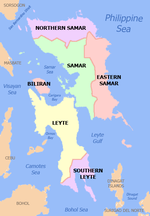
Leyte, officially the Province of Leyte, is a province in the Philippines located in the Eastern Visayas region, occupying the northern three-quarters of Leyte Island. Its capital is the city of Tacloban, administered independently from the province. Leyte is situated west of Samar Island, north of Southern Leyte and south of Biliran. To the west across the Camotes Sea is the province of Cebu.

<span class="mw-page-title-main">Southern Leyte</span> Province in Eastern Visayas, Philippines

Southern Leyte, officially the Province of Southern Leyte, is a province in the Philippines located in the Eastern Visayas region. Its capital is the city of Maasin. Southern Leyte comprised the third congressional district Leyte until it was made into an independent province in 1959. Southern Leyte includes Limasawa, an island to the south where the first Roman Catholic Mass in Philippine soil is believed to have taken place and thus considered to be the birthplace of Roman Catholicism in the Philippines.

<span class="mw-page-title-main">Biliran</span> Province in the Philippines

Biliran, officially the Province of Biliran, is an island province in the Philippines located in the Eastern Visayas region. Biliran is one of the country's smallest and newest provinces. Formerly a sub-province of Leyte, it became an independent province in 1992.

<span class="mw-page-title-main">Northern Samar</span> Province in Eastern Visayas, Philippines

Northern Samar, officially the Province of Northern Samar, is a province in the Philippines located in the Eastern Visayas region. Its capital is Catarman and is located at the northern portion of the island of Samar. Bordering the province to the south are the provinces of Samar and Eastern Samar. To the northwest, across the San Bernardino Strait is Sorsogon; to the east is the Philippine Sea of the Pacific Ocean and to the west is Samar Sea.

<span class="mw-page-title-main">Samar (province)</span> Province in Eastern Visayas, Philippines

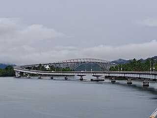
Samar, officially the Province of Samar, formerly named Western Samar, is a province in the Philippines located in the Eastern Visayas region. Its capital is the city of Catbalogan. It is bordered by Northern Samar, Eastern Samar, Leyte and Leyte Gulf, and includes several islands in the Samar Sea. Samar is connected to the island of Leyte via the San Juanico Bridge.

<span class="mw-page-title-main">Balangiga</span> Municipality in Eastern Samar, Philippines

Balangiga, officially the Municipality of Balangiga, is a 4th class municipality in the province of Eastern Samar, Philippines. According to the 2020 census, it has a population of 14,341 people.

<span class="mw-page-title-main">San Julian, Eastern Samar</span> Municipality in Eastern Samar, Philippines

San Julian, officially the Municipality of San Julian, is a 5th class municipality in the province of Eastern Samar, Philippines. According to the 2020 census, it has a population of 14,800 people.

<span class="mw-page-title-main">Catarman, Northern Samar</span> Capital of Northern Samar, Philippines

Catarman, officially the Municipality of Catarman, is a 1st class municipality and capital of the province of Northern Samar, Philippines. According to the 2020 census, it has a population of 97,879 people.

<span class="mw-page-title-main">Pinabacdao</span> Municipality in Samar, Philippines

Pinabacdao, officially the Municipality of Pinabacdao, is a 4th class municipality in the province of Samar, Philippines. According to the 2020 census, it has a population of 18,136 people.

<span class="mw-page-title-main">Borongan</span> Capital of Eastern Samar, Philippines

Borongan, officially the City of Borongan, is a 1st class component city and capital of the province of Eastern Samar, Philippines. According to the 2020 census, it has a population of 71,961 people.

<span class="mw-page-title-main">General MacArthur, Eastern Samar</span> Municipality in Eastern Samar, Philippines

General MacArthur, officially the Municipality of General MacArthur, is a 5th class municipality in the province of Eastern Samar, Philippines. According to the 2020 census, it has a population of 14,411 people.

<span class="mw-page-title-main">Guiuan</span> Municipality in Eastern Samar, Philippines

Guiuan, officially the Municipality of Guiuan, is a 2nd class municipality in the province of Eastern Samar, Philippines. It constitutes the southeastern extremity of Samar Island and some adjacent islands, surrounded by Leyte Gulf and the Philippine Sea, two major bodies of water that makes the town the surfing capital of the Visayas. According to the 2020 census, it has a population of 53,361 people, making it the most populous municipality in Eastern Samar and the second most populous administrative division in the entire province after the capital city Borongan.

<span class="mw-page-title-main">Lawaan</span> Municipality in Eastern Samar, Philippines

Lawaan, officially the Municipality of Lawaan, is a 5th class municipality in the province of Eastern Samar, Philippines. According to the 2020 census, it has a population of 13,003 people. It is home to Bolusao Watershed Forest Reserve, primarily located in Barangay Bolusao.

<span class="mw-page-title-main">Maydolong</span> Municipality in Eastern Samar, Philippines

Maydolong, officially the Municipality of Maydolong, is a 4th class municipality in the province of Eastern Samar, Philippines. According to the 2020 census, it has a population of 15,314 people.

<span class="mw-page-title-main">Mercedes, Eastern Samar</span> Municipality in Eastern Samar, Philippines

Mercedes, officially the Municipality of Mercedes, is a 5th class municipality in the province of Eastern Samar, Philippines. According to the 2020 census, it has a population of 6,112 people.

<span class="mw-page-title-main">Taft, Eastern Samar</span> Municipality in Eastern Samar, Philippines

Taft, officially the Municipality of Taft, is a 4th class municipality in the province of Eastern Samar, Philippines. According to the 2020 census, it has a population of 18,786 people.

<span class="mw-page-title-main">San Miguel, Leyte</span> Municipality in Leyte, Philippines

San Miguel, officially the Municipality of San Miguel, is a 4th class municipality in the province of Leyte, Philippines. According to the 2020 census, it has a population of 19,753 people.

<span class="mw-page-title-main">Tunga, Leyte</span> Municipality in Leyte, Philippines

Tunga, officially the Municipality of Tunga, is a 6th class municipality in the province of Leyte, Philippines. According to the 2020 census, it has a population of 7,656 people.

<span class="mw-page-title-main">Eastern Visayas</span> Administrative region of the Philippines

Eastern Visayas is an administrative region in the Philippines, designated as Region VIII. It consists of three main islands, Samar, Leyte and Biliran. The region has six provinces, one independent city and one highly urbanized city namely, Biliran, Leyte, Northern Samar, Samar, Eastern Samar, Southern Leyte, Ormoc and Tacloban. The highly urbanized city of Tacloban is the sole regional center. These provinces and cities occupy the easternmost islands of the Visayas group of islands.

<span class="mw-page-title-main">Central Visayas</span> Administrative region of the Philippines

Central Visayas is an administrative region in the Philippines, numerically designated as Region VII. It consists of four provinces: Cebu, Bohol, Negros Oriental, and Siquijor. The region also has three highly urbanized cities: Cebu City, Lapu-Lapu, and Mandaue.

References

  1. "List of Provinces". PSGC Interactive. Makati, Philippines: National Statistical Coordination Board. Archived from the original on 11 January 2013. Retrieved 13 April 2013.
  2. 1 2 3 Census of Population (2020). "Region VIII (Eastern Visayas)". Total Population by Province, City, Municipality and Barangay. Philippine Statistics Authority . Retrieved 8 July 2021.
  3. "Mapa ng mga Wika (Rehiyon) - Rehiyon VIII" (in Filipino). Commission on the Filipino Language. Archived from the original on 23 September 2021. Retrieved 23 September 2021.
  4. 1 2 Lancion, Conrado M. Jr. (1995). "The Provinces; Eastern Samar". Fast Facts about Philippine Provinces. cartography by de Guzman, Rey (The 2000 Millenium ed.). Makati, Metro Manila, Philippines: Tahanan Books. p. 72. ISBN   971-630-037-9 . Retrieved 4 December 2015.
  5. 1 2 Labro, Vicente S. (11 June 2011). "Guiuan's treasure chest of history, natural wonders". Philippine Daily Inquirer . Retrieved 24 April 2016.
  6. 1 2 3 4 5 6 "The Province of Eastern Samar". National Statistical Coordination Board. Archived from the original on 6 December 2014. Retrieved 24 April 2016.
  7. Republic Act No. 4221 (19 June 1965), An Act Creating the Provinces of Northern Samar, Eastern Samar and Western Samar , retrieved December 19, 2015
  8. Baylis, Paul; Te-Ping Chen (22 November 2013). "How One Philippine Town Avoided Calamity". The Wall Street Journal. Retrieved 20 December 2015.
  9. 1 2 "Province: Eastern Samar". PSGC Interactive. Quezon City, Philippines: Philippine Statistics Authority . Retrieved 8 January 2016.
  10. 1 2 Census of Population (2015). "Region VIII (Eastern Visayas)". Total Population by Province, City, Municipality and Barangay. Philippine Statistics Authority . Retrieved 20 June 2016.
  11. 1 2 Census of Population and Housing (2010). "Region VIII (Eastern Visayas)" (PDF). Total Population by Province, City, Municipality and Barangay. National Statistics Office . Retrieved 29 June 2016.
  12. 1 2 "Eastern Samar: Home of the Warays; Table 4. Household Population by Ethnicity and Sex: Eastern Samar, 2000". Philippine Statistics Authority. 7 June 2002. Archived from the original on 16 November 2013. Retrieved 25 July 2016.
  13. "Poverty incidence (PI):". Philippine Statistics Authority. Retrieved December 28, 2020.
  14. "Estimation of Local Poverty in the Philippines" (PDF). Philippine Statistics Authority. 29 November 2005.
  15. "2009 Official Poverty Statistics of the Philippines" (PDF). Philippine Statistics Authority. 8 February 2011.
  16. "Annual Per Capita Poverty Threshold, Poverty Incidence and Magnitude of Poor Population, by Region and Province: 1991, 2006, 2009, 2012 and 2015". Philippine Statistics Authority. 27 August 2016.
  17. "Annual Per Capita Poverty Threshold, Poverty Incidence and Magnitude of Poor Population, by Region and Province: 1991, 2006, 2009, 2012 and 2015". Philippine Statistics Authority. 27 August 2016.
  18. "Annual Per Capita Poverty Threshold, Poverty Incidence and Magnitude of Poor Population, by Region and Province: 1991, 2006, 2009, 2012 and 2015". Philippine Statistics Authority. 27 August 2016.
  19. "Updated Annual Per Capita Poverty Threshold, Poverty Incidence and Magnitude of Poor Population with Measures of Precision, by Region and Province: 2015 and 2018". Philippine Statistics Authority. 4 June 2020.