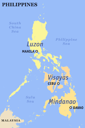
Mindanao is the second-largest island in the Philippines, after Luzon, and seventh-most populous island in the world. Located in the southern region of the archipelago, the island is part of an island group of the same name that also includes its adjacent islands, notably the Sulu Archipelago. According to the 2020 census, Mindanao has a population of 26,252,442 people, while the entire island group has an estimated population of 27,021,036 according to the 2021 census.

The Philippines is an archipelago that comprises 7,641 islands, and with a total land area of 300,000 square kilometers (115,831 sq mi), it is the world's fifth largest island country. The eleven largest islands contain 95% of the total land area. The largest of these islands is Luzon at about 105,000 square kilometers (40,541 sq mi). The next largest island is Mindanao at about 95,000 square kilometers (36,680 sq mi). The archipelago is around 800 kilometers (500 mi) from the Asian mainland and is located between Taiwan and Borneo.

The Visayas, or the Visayan Islands, are one of the three principal geographical divisions of the Philippines, along with Luzon and Mindanao. Located in the central part of the archipelago, it consists of several islands, primarily surrounding the Visayan Sea, although the Visayas are also considered the northeast extremity of the entire Sulu Sea. Its inhabitants are predominantly the Visayan peoples.

In the Philippines, regions are administrative divisions that primarily serve to coordinate planning and organize national government services across multiple local government units (LGUs). Most national government offices provide services through their regional branches instead of having direct provincial or city offices. Regional offices are usually but not necessarily located in the city designated as the regional center.

Marinduque, officially the Province of Marinduque, is an island province in the Philippines located in Southwestern Tagalog Region or Mimaropa, formerly designated as Region IV-B. Its capital is the municipality of Boac. Marinduque lies between Tayabas Bay to the north and Sibuyan Sea to the south. It is west of the Bondoc Peninsula of Quezon province; east of Mindoro Island; and north of the island province of Romblon. Some parts of the Verde Island Passage, the center of the center of world's marine biodiversity and a protected marine area, are also within Marinduque's provincial waters.

Leyte, officially the Province of Leyte, is a province in the Philippines located in the Eastern Visayas region, occupying the northern three-quarters of Leyte Island. Its capital is the city of Tacloban, administered independently from the province. Leyte is situated west of Samar Island, north of Southern Leyte and south of Biliran. To the west across the Camotes Sea is the province of Cebu.

Mimaropa, officially the Southwestern Tagalog Region, is an administrative region in the Philippines. It is one of two regions in the country having no land border with another region. The name is an acronym combination of its constituent provinces: Mindoro, Marinduque, Romblon and Palawan.

Southern Tagalog, designated as Region IV, was an administrative region in the Philippines that comprised the current regions of Calabarzon and Mimaropa, the province of Aurora of Central Luzon, and several cities of Metro Manila. The name remains as a cultural-geographical region only, which exempts Aurora.

Surigao del Norte, officially the Province of Surigao del Norte, is a province in the Philippines located in the Caraga region of Mindanao. The province was formerly under the jurisdiction of Region 10 until 1995. Its capital is Surigao City. The province comprises two major islands—Siargao and Bucas Grande—in the Philippine Sea, plus a small area at the northeastern tip of mainland Mindanao and other surrounding minor islands and islets. This mainland portion borders Agusan del Norte – between the Municipality of Alegria in Surigao del Norte and the Municipality of Kitcharao in Agusan del Norte; and the province of Surigao del Sur, to the south.

Sulu, officially the Province of Sulu, is a province of the Philippines in the Sulu Archipelago and part of the Bangsamoro Autonomous Region in Muslim Mindanao (BARMM).

Central Luzon, designated as Region III, is an administrative region in the Philippines, primarily serving to organize the 7 provinces of the vast central plains of the island of Luzon, for administrative convenience. The region contains the largest plain in the country and produces most of the country's rice supply, earning itself the nickname "Rice Granary of the Philippines". Its provinces are: Aurora, Bataan, Bulacan, Nueva Ecija, Pampanga, Tarlac and Zambales. Pangasinan was formerly a province of Central Luzon before President Marcos signed Presidential Decree No. 1, 1972, incorporating it into Ilocos Region. Additionally, the province of Aurora was part of the defunct political region Southern Tagalog when the region was divided into Calabarzon and Mimaropa, upon the issuance of Executive Order No. 103, dated May 17, 2002, by then-President Gloria Macapagal Arroyo, which transferred Aurora to Central Luzon.
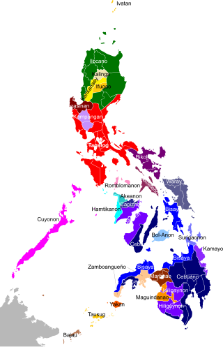
The Philippines is inhabited by more than 182 ethnolinguistic groups, many of which are classified as "Indigenous Peoples" under the country's Indigenous Peoples' Rights Act of 1997. Traditionally-Muslim peoples from the southernmost island group of Mindanao are usually categorized together as Moro peoples, whether they are classified as Indigenous peoples or not. About 142 are classified as non-Muslim Indigenous People groups, and about 19 ethnolinguistic groups are classified as neither indigenous nor moro. Various migrant groups have also had a significant presence throughout the country's history.
The Philippines is divided into four levels of administrative divisions, with the lower three being defined in the Local Government Code of 1991 as local government units (LGUs). They are, from the highest to the lowest:
- Regions are mostly used to organize national services. Of the 17 regions, only one—the Bangsamoro Autonomous Region in Muslim Mindanao—has an elected government to which the central government has devolved competencies.
- Provinces, independent cities, and one independent municipality (Pateros)
- Component cities and municipalities within a province
- Barangays within a city or municipality

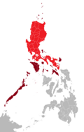
Mega Manila is a megalopolis on the island of Luzon in the Philippines. There are varying definitions of the megalopolis, but it is generally seen as encompassing the administrative regions of Central Luzon, Calabarzon, and Metro Manila. On some occasions, the administrative region of Mimaropa is also included.
The super regions of the Philippines are an informal and de facto defunct grouping of parts of regions and provinces of the Philippines based on their economic strengths. According to Executive Order No. 561, which establishes these regions,
"[These] groupings neither supersede current political boundaries nor alter the regional development councils as established by existing laws and issuances."

The Christian And Missionary Alliance Churches of the Philippines (CAMACOP) is a Christian evangelical group in the Philippines that originated from The Christian and Missionary Alliance (C&MA). It is one of the largest evangelical groups in the Philippines.
In August 2016, the southwest monsoon brought heavy rainfall and flooding to Metro Manila and nearby regions.
Philippine ceramics are mostly earthenware, pottery that has not been fired to the point of vitrification. Other types of pottery like tradeware and stoneware have been fired at high enough temperatures to vitrify. Earthenware ceramics in the Philippines are mainly differentiated from tradeware and stoneware by the materials used during the process and the temperature at which they are fired. Additionally, earthenware and stoneware pottery can generally be referred to as ceramics that are made with local materials, while tradeware ceramics can generally be referred to as ceramics that are made with non-local materials.
Federalism was one of the main campaign promises of Rodrigo Duterte when he ran for President of the Philippines in 2016. His administration pursued a proposal which would shift the Philippines from being under a unitary form of government to a federal one.