Bracebridge, Ontario

Last updated
Bracebridge
Town of Bracebridge
Bracebridge ON.JPG
View of the road into central Bracebridge.
Motto: 
The Heart of Muskoka
Canada Southern Ontario location map 2.png
Red pog.svg
Bracebridge
Coordinates: 45°02′N79°18′W / 45.033°N 79.300°W / 45.033; -79.300
Country Canada
Province Ontario
District Muskoka
Incorporated1875 (village)
Incorporated1889 (town)
Government
  MayorRick Maloney
  Governing BodyBracebridge Town Council
  Federal riding Parry Sound-Muskoka
  Prov. riding Parry Sound—Muskoka
Area
[1]
  Land628.22 km2 (242.56 sq mi)
Population
 (2021) [1]
  Total17,305
  Density28.1/km2 (73/sq mi)
Time zone UTC−5 (EST)
  Summer (DST) UTC−4 (EDT)
Forward sortation area
P1L
Area code 705 & 249
Highways Ontario 11 crown.svg  Highway 11
Ontario 118 crown.svg  Highway 118
Website www.bracebridge.ca

Bracebridge is a town and the seat of the Muskoka District Municipality in Ontario, Canada.

Contents

The town was built around a waterfall on the Muskoka River in the centre of town, and is known for its other nearby waterfalls (Wilson's Falls, High Falls, etc.). It was first incorporated in 1875. [2]

The town is the seat of the district government, a centre of tourism for the Muskoka area, and home to several historical sites, such as the Clock Tower, Woodchester Villa, and the Silver Bridge, which joins Manitoba Street with Ecclestone Drive. The Silver Bridge was repaired in 2002.

History

Bracebridge and Muskoka River circa 1880 DENT(1881) 1.079 BRACEBRIDGE, MUSKOKA.jpg
Bracebridge and Muskoka River circa 1880
View down Manitoba Street in Bracebridge circa 1910 Bracebridge Manitoba Street c 1910.jpg
View down Manitoba Street in Bracebridge circa 1910

The character of the town of Bracebridge is shaped by its proximity to Lake Muskoka to which it is connected by 10 km (6.2 mi) of the Muskoka River, and by the promise of abundant water power afforded by the great waterfall at the foot of the downtown. [2] Early growth of the town occurred in proximity to the falls which powered the first factory. The arrival of the Grand Trunk Railway cemented the town's role as a transportation hub for the area.

Modern settlement of the town began in the 1860s, beginning at first with a few log huts. The Muskoka colonization road had been completed to the first falls on the north branch of the Muskoka River by 1862. Entrepreneurs began to take advantage of the area's water power. With the advent of steamship service on Lake Muskoka a few years later, Bracebridge prospered as the main distribution centre for the region. [3]

By 1869, Bracebridge was a village with a population of 160 in the Township of Macaulay, Victoria County. (In 1868 Macauley and six additional townships had been detached from the County and transferred to the new District of Muskoka, but were not withdrawn for municipal purposes until 1877.) The village was established on the Muskoka River. There were stages in winter and boats in summer from Barrie to Washago. The average price of wild land was $2 to $5 an acre while improved land was $10 per acre. [4]

By 1870 the village had a population of about 400, growing to reach a total of about 2,000 by the turn of the 20th century. [2] The village was incorporated in 1875 and became a town under an Act of Parliament in 1889. In 1894 Bracebridge became the first town in Ontario to have its own hydro generating station. In 1971 Macaulay Township was merged into Bracebridge.

The municipal boundaries of Bracebridge also encompass the smaller communities of Clear Lake, Falkenburg (ghost town), Falkenburg Station, Fraserburg, Germania, Lakewood, Matthiasville, Monsell (ghost town), Purbrook, Rocksborough, Springdale Park, Stoneleigh, Uffington and Vankoughnet.

Transportation

The Bracebridge Town Express 'trolley' Bracebridge Town Express.jpg
The Bracebridge Town Express 'trolley'

Bracebridge is immediately adjacent to Highway 11, a major provincial highway that connects the community to Greater Toronto in under 2 hours, as well as to markets in Northern Ontario. Muskoka Airport, which serves general aviation and scheduled flights from Billy Bishop Toronto City Airport, is located 5 km south of Bracebridge.

While rail service to Bracebridge has been discontinued, the community is serviced by coach bus line Ontario Northland Motor Coach Services that departs from the Bracebridge Quality Inn and takes passengers south to Toronto and north to North Bay. In 2016 the municipality launched Bracebridge Transit, a one-hour, single-route schedule that gets residents around the urban core. Bracebridge Mobility also offers door-to-door service to individuals who are unable to access the regular transit service due to mobility issues. The site of the Bracebridge station with wait building remains.

Climate

Climate data for Bracebridge, Ontario (Muskoka Airport) 1981–2010
MonthJanFebMarAprMayJunJulAugSepOctNovDecYear
Record high humidex 12.011.025.933.435.341.242.341.844.931.025.023.044.9
Record high °C (°F)13.9
(57.0)
12.0
(53.6)
25.6
(78.1)
30.2
(86.4)
31.7
(89.1)
35.0
(95.0)
33.9
(93.0)
35.0
(95.0)
34.4
(93.9)
27.8
(82.0)
24.4
(75.9)
18.8
(65.8)
35.0
(95.0)
Mean daily maximum °C (°F)−4.8
(23.4)
−2.5
(27.5)
2.6
(36.7)
10.6
(51.1)
17.8
(64.0)
22.5
(72.5)
24.8
(76.6)
23.9
(75.0)
19.3
(66.7)
12.2
(54.0)
4.9
(40.8)
−1.3
(29.7)
10.8
(51.4)
Daily mean °C (°F)−10.3
(13.5)
−8.4
(16.9)
−3.1
(26.4)
4.8
(40.6)
11.4
(52.5)
16.2
(61.2)
18.7
(65.7)
17.8
(64.0)
13.4
(56.1)
7.1
(44.8)
0.8
(33.4)
−5.9
(21.4)
5.2
(41.4)
Mean daily minimum °C (°F)−15.8
(3.6)
−14.3
(6.3)
−8.8
(16.2)
−1.0
(30.2)
5.0
(41.0)
9.9
(49.8)
12.6
(54.7)
11.8
(53.2)
7.5
(45.5)
1.9
(35.4)
−3.2
(26.2)
−10.4
(13.3)
−0.4
(31.3)
Record low °C (°F)−40.0
(−40.0)
−41.5
(−42.7)
−34.3
(−29.7)
−21.1
(−6.0)
−7.8
(18.0)
−2.2
(28.0)
1.7
(35.1)
−1.1
(30.0)
−5.0
(23.0)
−11.1
(12.0)
−23.3
(−9.9)
−41.1
(−42.0)
−41.5
(−42.7)
Record low wind chill −49.7−50.7−43.2−27.6−11.4−5.90.0−4.3−8.8−16.9−30.2−48−50.7
Average precipitation mm (inches)93.0
(3.66)
64.7
(2.55)
73.3
(2.89)
76.6
(3.02)
102.4
(4.03)
85.5
(3.37)
93.7
(3.69)
82.2
(3.24)
111.9
(4.41)
105.2
(4.14)
116.2
(4.57)
100.4
(3.95)
1,105.1
(43.51)
Average rainfall mm (inches)26.5
(1.04)
19.7
(0.78)
38.0
(1.50)
61.8
(2.43)
101.8
(4.01)
85.5
(3.37)
93.7
(3.69)
82.2
(3.24)
111.9
(4.41)
100.4
(3.95)
81.2
(3.20)
29.7
(1.17)
832.2
(32.76)
Average snowfall cm (inches)87.2
(34.3)
57.6
(22.7)
40.6
(16.0)
15.5
(6.1)
0.7
(0.3)
0.0
(0.0)
0.0
(0.0)
0.0
(0.0)
0.0
(0.0)
5.2
(2.0)
40.3
(15.9)
91.1
(35.9)
338.1
(133.1)
Average precipitation days (≥ 0.2 mm)20.415.914.413.914.412.811.712.714.016.218.520.5185.4
Average rainy days (≥ 0.2 mm)4.74.16.710.814.312.811.712.714.015.212.06.5125.4
Average snowy days (≥ 0.2 cm)18.814.510.45.00.250.00.00.00.041.89.217.277.1
Average relative humidity (%)71.663.256.652.853.656.056.859.562.964.972.375.662.2
Source: Environment Canada [5] [6]

Education

Bracebridge is served by several elementary schools and two high schools: Bracebridge and Muskoka Lakes Secondary School, and Saint Dominic Catholic Secondary School. Public education is administered by the Trillium Lakelands District School Board, [7] and Catholic education is administered by the Simcoe Muskoka Catholic District School Board. [8]

Georgian College operates a satellite campus in the town with programming that supports the local labour market. Nipissing University operated in Bracebridge for over 21 years but chose to consolidate its operations in 2016 resulting in the closure of the local campus. The facility was purchased in 2018 by a private institude.

Demographics

Historical populations
YearPop.±%
1871700    
18911,419+102.7%
19012,479+74.7%
1911 2,776+12.0%
19212,451−11.7%
19312,436−0.6%
19412,341−3.9%
19512,684+14.7%
19612,927+9.1%
19716,903+135.8%
19819,063+31.3%
199112,308+35.8%
2001 13,751+11.7%
2006 15,652+13.8%
2011 15,414−1.5%
2016 16,010+3.9%
2021 17,305+8.1%
Note: 2011 census population
corrected by Statistics Canada [9]

In the 2021 Census of Population conducted by Statistics Canada, Bracebridge had a population of 17,305 living in 7,233 of its 9,053 total private dwellings, a change of 8.1% from its 2016 population of 16,010. With a land area of 615.2 km2 (237.5 sq mi), it had a population density of 28.1/km2 (72.9/sq mi) in 2021. [10]

Canada census – Bracebridge community profile
2021 2016 2011
Population17,305 (+8.1% from 2016)16,010 (3.9% from 2011)15,414 [9] (-1.5% from 2006)
Land area615.20 km2 (237.53 sq mi)628.22 km2 (242.56 sq mi)625.66 km2 (241.57 sq mi)
Population density28.1/km2 (73/sq mi)25.5/km2 (66/sq mi)24.6/km2 (64/sq mi)
Median age51.2 (M: 49.6, F: 52.4)50.0 (M: 48.5, F: 51.2)47.2 (M: 45.6, F: 48.5)
Private dwellings9,053 (total)  7,233 (occupied)8,874 (total) 8,519 [9] (total) 
Median household income$85,000$69,461
References: 2021 [11] 2016 [12] 2011 [13] earlier [14] [15]

Sports

The Town of Bracebridge built a Sportsplex in 2006 which contains a rock climbing wall, indoor track, eight-lane swimming pool and fitness studio. The town partnered with the Muskoka Limberettes Gymnastics Club to create a gymnastics facility in the same building. The Sportsplex is part of the same complex including the Bracebridge and Muskoka Lakes Secondary School and Rene M. Caisse Memorial Theatre. [16]

Bracebridge also opened a new 3.75 Million dollar softball venue called Peake Fields at Verena Acres. This facility supports a Men's League, Women's League, and Minor Ball, as well as slow pitch. The Men's fastball League has been running for some 35 years, and has produced 4 Ontario Intermediate Fastball Championships, and 3 Canadian Championships, with all local players.

Plans are currently in place for a new Arena/Fieldhouse/Library complex that is now currently under construction with an expected opening of the facility in March 2023 [17]

Attractions and venues

Bracebridge is the home of Santa's Village, a Christmas theme park, established in 1955. It was inspired by the town's location at 45 degrees latitude, halfway between the equator and the North Pole. In 2016, Bracebridge held its first annual Fire and Ice Festival.

Media

Bracebridge is served by the local radio stations CFBG-FM and CJMU-FM. [18] [19] Local newspapers include Bracebridge Examiner, District Weekender, Muskoka Sun and Muskoka Advance.

The first newspaper in Bracebridge was the Northern Advocate begun in 1870 by Thomas McMurray. It was joined in 1872 by the Free Grant Gazette owned by E.F. Stephenson. The Advocate ceased publication in 1874 and was bought out by Stephenson. Competition resumed, however, in 1878 when Mr Gaffe and Mr Oaten founded the Muskoka Herald. [2]

Notable residents

See also

Related Research Articles

<span class="mw-page-title-main">Huntsville, Ontario</span> Town in Muskoka, Canada

Huntsville is a town in Muskoka. It is located 215 kilometres (134 mi) north of Toronto and 130 kilometres (81 mi) south of North Bay. Of the three big Muskoka towns, it is the largest by population and land area (710.64 km2).

<span class="mw-page-title-main">Gravenhurst, Ontario</span> Town in Ontario, Canada

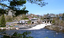
Gravenhurst is a town in the Muskoka Region of Ontario, Canada. It is located approximately 15 kilometres (9.3 mi) south of Bracebridge, Ontario. The Town of Gravenhurst includes a large area of the District of Muskoka, known to Ontarians as "cottage country." The town centre borders on two lakes: Lake Muskoka, which is the largest lake in the region, and Gull Lake, a smaller cottage-bordered lake. Another lake, Kahshe Lake, is situated 10 kilometres (6.2 mi) south of the town.

<span class="mw-page-title-main">Regional Municipality of Niagara</span> Regional municipality in Ontario, Canada

The Regional Municipality of Niagara, also colloquially known as the Niagara Region or Region of Niagara, is a regional municipality comprising twelve municipalities of Southern Ontario, Canada. The regional seat is in Thorold. It is the southern end of the Golden Horseshoe, the largest megalopolis in Canada.

<span class="mw-page-title-main">Erin, Ontario</span> Town in Ontario, Canada

Erin is a town in Wellington County, approximately 80 kilometres (50 mi) northwest of Toronto, Ontario, Canada. Erin is bordered by the Town of Caledon, Ontario to the east, the Town of Halton Hills to the south, the Township of Guelph/Eramosa to the west and the Township of East Garafraxa to the north.

<span class="mw-page-title-main">New Tecumseth</span> Town in Ontario, Canada

New Tecumseth is a town in Simcoe County, in south-central Ontario, Canada. While it is not officially a part of the Greater Toronto Area, it is counted, in terms of the census, as being a part of the Toronto Census Metropolitan Area.

<span class="mw-page-title-main">District Municipality of Muskoka</span> Regional municipality in Ontario, Canada

The District Municipality of Muskoka, more generally referred to as the District of Muskoka or Muskoka, is a regional municipality in Central Ontario, Canada. It extends from Georgian Bay in the west, to the northern tip of Lake Couchiching in the south, to the western border of Algonquin Provincial Park in the east. A two-hour drive north of Toronto, it spans 6,475 km2 (2,500 sq mi). It has some 1,600 lakes, making it a popular cottaging destination.

<span class="mw-page-title-main">Georgian Bay, Ontario</span> Township in Ontario, Canada

The Township of Georgian Bay is an area municipality of the District Municipality of Muskoka, in south-central Ontario, Canada. It is located on the Severn River, where it empties into the eponymous Georgian Bay. The municipal offices are at Port Severn.

<span class="mw-page-title-main">Lake of Bays</span> Township municipality in Ontario, Canada

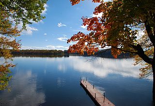
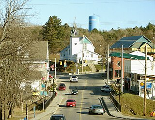
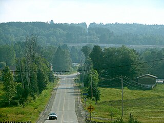
Lake of Bays is a township municipality within the District Municipality of Muskoka, Ontario, Canada. The township, situated 193 kilometres (120 mi) north of Toronto, is named after the Lake of Bays. During the 2016 census, the township had a population of 3,167 and encompassed 677.91 square kilometres (261.74 sq mi) of land.

<span class="mw-page-title-main">Muskoka Lakes</span> Township in Ontario, Canada

The Township of Muskoka Lakes is a municipality of the District Municipality of Muskoka, Ontario, Canada. It has a year-round population of 7,652.

<span class="mw-page-title-main">Simcoe County</span> County in Ontario, Canada

Simcoe County is located in the central portion of Southern Ontario, Canada. The county is just north of the Greater Toronto Area, stretching from the shores of Lake Simcoe in the east to Georgian Bay in the west. Simcoe County forms part of the Greater Golden Horseshoe area, a densely populated and industrialized region, centred on the Greater Toronto Area.

<span class="mw-page-title-main">Bancroft, Ontario</span> Town in Ontario, Canada

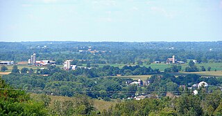
Bancroft is a town located on the York River in Hastings County in the Canadian province of Ontario. It was first settled in the 1850s by United Empire Loyalists and Irish immigrants. From the mid-1950s to about 1982, mining was the primary industry. A village until 1999, Bancroft then merged with Dungannon Township to form the Town of Bancroft. The population at the time of the 2016 Census was 3,881; the regional population is 40,000. There are 150,000 visitors to Bancroft, annually.

<span class="mw-page-title-main">Havelock-Belmont-Methuen</span> Township in Ontario, Canada

Havelock-Belmont-Methuen is a township in central-eastern Ontario, Canada, in Peterborough County. On January 1, 1998, Belmont and Methuen Township amalgamated with the Village of Havelock to form what is now Havelock-Belmont-Methuen.

<span class="mw-page-title-main">Ramara</span> Township in Ontario, Canada

Ramara is a lower-tier township municipality in Simcoe County, Ontario, Canada.

<span class="mw-page-title-main">West Nipissing</span> Municipality in Ontario, Canada

West Nipissing is a municipality in Northeastern Ontario, Canada, on Lake Nipissing in the Nipissing District. It was formed on January 1, 1999, with the amalgamation of seventeen and a half former towns, villages, townships and unorganized communities.

<span class="mw-page-title-main">Burk's Falls</span> Village in Ontario, Canada

Burk's Falls is an incorporated village in the Almaguin Highlands region of Parry Sound District, Ontario, Canada, located 265 kilometres (165 mi) north of Toronto and 90 kilometres (56 mi) south of North Bay, Ontario. The village, and the waterfall on the site, were named by David Francis Burk of Oshawa, after he selected the land surrounding the waterfall in the Free Land Grant Act. Burk's Falls is part of the Magnetawan River waterway.

<span class="mw-page-title-main">Minden Hills</span> Township in Ontario, Canada

Minden Hills is a township in and the county seat of Haliburton County, Ontario, Canada. It is an amalgam of the townships of Snowdon, Lutterworth, Anson, Hindon and Minden. It is usually referred to as Minden, after its largest community.

<span class="mw-page-title-main">Strathroy-Caradoc</span> Municipality in Ontario, Canada

Strathroy-Caradoc is a municipality located in Southwestern Ontario, Canada. It is 35 kilometres (22 mi) west of London.

<span class="mw-page-title-main">Perry, Ontario</span> Township in Ontario, Canada

Perry is a township in the Canadian province of Ontario, located in the Almaguin Highlands region of Parry Sound District.

<span class="mw-page-title-main">Dysart et al</span> United township in Ontario, Canada

The United Townships of Dysart, Dudley, Harcourt, Guilford, Harburn, Bruton, Havelock, Eyre and Clyde, commonly known as the Municipality of Dysart et al, is a municipality in Haliburton County in Central Ontario, Canada. The original townships were of the Canadian Land and Emigration Company.

<span class="mw-page-title-main">Stirling-Rawdon</span> Township in Ontario, Canada

Stirling-Rawdon is a township in the Canadian province of Ontario, located in Hastings County. It was formed on January 1, 1998, through the amalgamation of Rawdon Township with the Village of Stirling. Stirling was named the 2012 Kraft Hockeyville winner, after gaining more than 3.9 million votes.

References

  1. 1 2 "Census Profile, 2016 Census: Bracebridge, Town". Statistics Canada. 8 February 2017. Retrieved June 21, 2019.
  2. 1 2 3 4 Hopkins, J. Castell (1896). Encyclopedic Canada or The Progress of a Nation. Toronto: Bradley-Garretson Company Ltd. pp. 346–350.
  3. "Founding of Bracebridge, The". Ontario Heritage Trust. Retrieved June 21, 2019.
  4. The province of Ontario gazetteer and directory. H. McEvoy Editor and Compiler, Toronto : Robertson & Cook, Publishers, 1869
  5. "Muskoka A, Ontario". Canadian Climate Normals 1981–2010. Environment Canada. 25 September 2013. Archived from the original on August 21, 2019. Retrieved August 21, 2019.
  6. "Muskoka A, Ontario". Canadian Climate Normals 1981–2010. Environment Canada. Archived from the original on 2020-07-18. Retrieved August 21, 2019.
  7. "Schools". Trillium Lakelands District School Board. Archived from the original on March 27, 2012. Retrieved March 29, 2012.
  8. "Our Schools". Simcoe Muskoka Catholic District School Board. Retrieved March 29, 2012.
  9. 1 2 3 "Corrections and updates". Statistics Canada. 2012-09-19. Retrieved 2012-10-11.
  10. "Population and dwelling counts: Canada, provinces and territories, census divisions and census subdivisions (municipalities), Ontario". Statistics Canada. February 9, 2022. Retrieved March 30, 2022.
  11. "2021 Community Profiles". 2021 Canadian Census . Statistics Canada. February 4, 2022. Retrieved 2023-10-19.
  12. "2016 Community Profiles". 2016 Canadian Census . Statistics Canada. August 12, 2021. Retrieved 2017-03-16.
  13. "2011 Community Profiles". 2011 Canadian Census . Statistics Canada. March 21, 2019. Retrieved 2012-03-08.
  14. "2006 Community Profiles". 2006 Canadian Census . Statistics Canada. August 20, 2019.
  15. "2001 Community Profiles". 2001 Canadian Census . Statistics Canada. July 18, 2021.
  16. "A Trip Around Lake Muskoka With Norman Bethune - And A Cure For Cancer", by Martin Avery, 2013, ISBN   978-1-304-60093-6
  17. Hartill, Mary-beth (27 October 2005). "New Arena Complex Moving Ahead In Bracebridge". MuskokaRegion.com. Bracebridge. Retrieved 11 January 2021.
  18. "CFBG-FM, Moose FM, Bracebridge". History of Canadian Broadcasting. Archived from the original on 27 September 2019. Retrieved 20 September 2020.
  19. "CJMU-FM, Country 102, Bracebridge-Gravenhurst". History of Canadian Broadcasting. Archived from the original on 20 September 2020. Retrieved 20 September 2020.