Kawartha Lakes

Last updated
Kawartha Lakes
City of Kawartha Lakes
Kawartha Lakes city hall.JPG
Kawartha Lakes city hall in Lindsay
Kawartha Lakes Logo.png
Motto: 
"Jump In"
Map of Ontario KAWARTHA LAKES.svg
Kawartha Lakes' location within Ontario
Coordinates: 44°21′N78°45′W / 44.350°N 78.750°W / 44.350; -78.750
CountryCanada
Province Ontario
County (historical) Victoria
Formed by political merger January 1, 2001
Seat Lindsay
Government
  MayorDoug Elmslie
  Deputy MayorCharlie McDonald
  CouncilCity of Kawartha Lakes Council
   MP Jamie Schmale (CPC)
   MPP Laurie Scott (PC)
Area
[1]
  Land3,084.38 km2 (1,190.89 sq mi)
Population
 (2021) [2]
  Total79,247
  Density26.1/km2 (68/sq mi)
Time zone UTC-5 (EST)
  Summer (DST) UTC-4 (EDT)
Postal Code
Area code 705 / 249
Website www.kawarthalakes.ca

The City of Kawartha Lakes (2021 population 79,247 [2] ) is a unitary municipality in Central Ontario, Canada. It is a municipality legally structured as a single-tier city; however, Kawartha Lakes is the size of a typical Ontario county and is mostly rural. It is the second largest single-tier municipality in Ontario by land area (after Greater Sudbury).

Contents

The main population centres are the communities of Lindsay (population: 22,367), Bobcaygeon (population: 3,576), Fenelon Falls (population: 2,490), Omemee (population: 1,060) and Woodville (population: 718).

History

The Kawartha Lakes area is situated on the traditional territory of the Anishinaabeg, Huron-Wendat and more recently, the Haudenosaunee peoples. [3] The city's name is from the Kawartha Lakes. Kawartha is an anglicization of Ka-wa-tha (from Ka-wa-tae-gum-maug or Gaa-waategamaag), which was coined in 1895 by Martha Whetung of the Curve Lake First Nations. It meant "land of reflections" in the Anishinaabe language, according to Whetung. The word was later changed by tourism promoters to Kawartha, meaning "bright waters and happy lands." [4]

Prior to its restructuring as a city, the area was known as Victoria County. The city was created in 2001, during the ruling provincial Progressive Conservative party's "Common Sense Revolution". Through provincial legislation, the former Victoria County and its constituent municipalities were amalgamated into one entity named the City of Kawartha Lakes.

This act was implemented by the Victoria County Restructuring Commission, led by commissioner Harry Kitchen. [5] Despite a general opposition from residents of the area, the provincial government pushed forward with the amalgamation, [6] [7] which officially came into effect on January 1, 2001.

By a narrow margin (51% for, 49% against), the citizens of Kawartha Lakes voted to de-amalgamate in a November 2003 local plebiscite, but the provincial and municipal governments have not taken any steps since the vote to initiate de-amalgamation. [7]

Demographics

In the 2021 Census of Population conducted by Statistics Canada, Kawartha Lakes had a population of 79,247 living in 32,708 of its 38,947 total private dwellings, a change of

Canada census – Kawartha Lakes community profile
2021 2016 2011
Population79,247 (+5.1% from 2016)75,423 (3% from 2011)73,219 (-1.8% from 2006)
Land area3,033.66 km2 (1,171.30 sq mi)3,084.38 km2 (1,190.89 sq mi)3,083.06 km2 (1,190.38 sq mi)
Population density26.1/km2 (68/sq mi)24.5/km2 (63/sq mi)23.7/km2 (61/sq mi)
Median age51.6 (M: 50.4, F: 53.2)46.7 (M: 45.8, F: 47.6)48.4 (M: 47.6, F: 49.2)
Private dwellings38,947 (total)  32,708 (occupied)38,444 (total) 37,161 (total) 
Median household income$82,000$69,465
References: 2021 [9] 2016 [10] 2011 [11] earlier [12] [13]

In the 2016 census, the population of the Lindsay urban area was 20,713, up from 20,291 in 2011. [14]

Town of Lindsay
CensusPopulationChange (%)
202122,367Increase2.svg8.0%
201620,713Increase2.svg24.1%
199116,696Increase2.svg22.8%
198113,596Increase2.svg6.7%
197112,746Increase2.svg11.8%
196111,399Increase2.svg18.7%
19519,603Increase2.svg15.1%
19418,345Increase2.svg11.2%
19317,505Decrease2.svg1.5%
19217,620Increase2.svg9.4%
19116,964Decrease2.svg0.6%
19017,003Increase2.svg15.2%
18916,081Increase2.svg19.7%
18815,080Increase2.svg25.5%
18714,049n/a

Ethnicity

Ethnic Origins 2021 [15]

Only ethnic groups that comprise greater than 1% of the population are included. Note that a person can report more than one group

In 2021, Kawartha Lakes was 93.7% white/European, 3.4% visible minorities, and 2.9% Indigenous. The largest visible minority groups were South Asian (0.9%), Black (0.8%) and Chinese (0.5%).

Panethnic groups in the Municipality of Kawartha Lakes (2001−2021)
Panethnic
group
2021 [16] 2016 [17] 2011 [18] 2006 [19] 2001 [20]
Pop. %Pop.%Pop.%Pop.%Pop.%
European [lower-alpha 1] 72,38569,85068,81070,91566,990
Indigenous 2,2101,9951,3801,255785
South Asian 675340330360120
African 605280265250160
East Asian [lower-alpha 2] 540360415280160
Southeast Asian [lower-alpha 3] 220315857585
Latin American 19040356525
Middle Eastern [lower-alpha 4] 55115254085
Other [lower-alpha 5] 145759011045
Total responses77,23073,37571,45073,36068,460
Total population79,24775,42373,21974,56169,179
Note: Totals greater than 100% due to multiple origin responses

Religion

53.8% of Kawartha Lakes residents were Christian in 2021, [15] down from 68.8% in 2011. [21] 28.3% were Protestant, including 12.7% United Church, 7.0% Anglican, 3.3% Presbyterian and 2.5% Baptist. 15.6% were Catholic, 5.8% were Christian n.o.s, and 4.1% belonged to other Christian denominations or Christian-related traditions. Non-religious and secular residents were 44.5% of the population, up from 30.3% in 2011. 1.7% of the population belonged to other religions and spiritual traditions, up from 0.9% in 2011. The largest non-Christian religion was Hinduism (0.4%).

Government

Kawartha Lakes is governed by a City Council consisting of the Mayor and one councillor from each of the City's wards. From 2001 to the 2018 election, there were 16 wards and councillors, but this was changed to 8 wards for the 2018 election. [22] The mayor and councillors are elected for four-year terms, as mandated by the Government of Ontario for all municipalities in the province. The mayor of Kawartha Lakes is Doug Elmslie and Deputy Mayor is Charlie McDonald. The Deputy Mayor is a special appointment for one of the 8 councillors and is elected each year by members of Council at a Regular Council meeting in December.

For purposes of electing representatives both provincially and federally, the city is within the riding of Haliburton—Kawartha Lakes—Brock. Its Member of Provincial Parliament (MPP) is Laurie Scott of the Progressive Conservative Party, elected in 2018. Its federal Member of Parliament (MP) is Jamie Schmale of the Conservative Party, who was elected in 2015.

Mayors of Kawartha Lakes include:

Communities

Climate

The Kawartha Lakes area has a humid continental climate with warm, sometimes humid summers and cold snowy winters. The snowier areas are typically the ones closer to large lakes, and snow usually ranges from 150 cm to 200 cm in a year in most areas.

Climate data for Janetville, Ontario, 1981-2010 normals, extremes 1981-2010
MonthJanFebMarAprMayJunJulAugSepOctNovDecYear
Record high °C (°F)13.0
(55.4)
13.0
(55.4)
24.5
(76.1)
30.5
(86.9)
33.0
(91.4)
34.0
(93.2)
36.5
(97.7)
36.0
(96.8)
33.0
(91.4)
27.5
(81.5)
21.0
(69.8)
18.5
(65.3)
36.5
(97.7)
Mean daily maximum °C (°F)−3.3
(26.1)
−1.7
(28.9)
3.5
(38.3)
11.6
(52.9)
18.2
(64.8)
23.8
(74.8)
26.3
(79.3)
25.3
(77.5)
20.6
(69.1)
13.4
(56.1)
6.0
(42.8)
−0.5
(31.1)
11.9
(53.5)
Mean daily minimum °C (°F)−12.0
(10.4)
−11.4
(11.5)
−6.7
(19.9)
0.4
(32.7)
6.0
(42.8)
11.2
(52.2)
13.8
(56.8)
13.0
(55.4)
8.9
(48.0)
3.4
(38.1)
−1.9
(28.6)
−8.5
(16.7)
1.4
(34.4)
Record low °C (°F)−35.0
(−31.0)
−31.0
(−23.8)
−31.5
(−24.7)
−15.0
(5.0)
−5.0
(23.0)
−2.0
(28.4)
4.0
(39.2)
−0.5
(31.1)
−4.0
(24.8)
−9.5
(14.9)
−18.5
(−1.3)
−33.0
(−27.4)
−35.0
(−31.0)
Average precipitation mm (inches)72.3
(2.85)
55.3
(2.18)
61.7
(2.43)
74.6
(2.94)
88.7
(3.49)
84.0
(3.31)
73.7
(2.90)
89.2
(3.51)
97.2
(3.83)
80.7
(3.18)
99.0
(3.90)
72.7
(2.86)
949.1
(37.38)
Average snowfall cm (inches)47.2
(18.6)
34.0
(13.4)
29.4
(11.6)
10.3
(4.1)
0.1
(0.0)
0.0
(0.0)
0.0
(0.0)
0.0
(0.0)
0.0
(0.0)
2.1
(0.8)
21.2
(8.3)
42.3
(16.7)
186.6
(73.5)
Source: Environment Canada [23]
Climate data for Lindsay (1981−2010)
MonthJanFebMarAprMayJunJulAugSepOctNovDecYear
Record high °C (°F)11.5
(52.7)
11.5
(52.7)
24.0
(75.2)
29.5
(85.1)
32.0
(89.6)
34.0
(93.2)
36.5
(97.7)
36.5
(97.7)
32.5
(90.5)
27.0
(80.6)
21.1
(70.0)
17.5
(63.5)
36.5
(97.7)
Mean daily maximum °C (°F)−4.1
(24.6)
−2.1
(28.2)
2.9
(37.2)
11.2
(52.2)
18.2
(64.8)
23.4
(74.1)
26.0
(78.8)
24.8
(76.6)
20.0
(68.0)
12.8
(55.0)
5.6
(42.1)
−0.6
(30.9)
11.5
(52.7)
Daily mean °C (°F)−8.4
(16.9)
−6.8
(19.8)
−1.8
(28.8)
6.0
(42.8)
12.5
(54.5)
17.7
(63.9)
20.3
(68.5)
19.2
(66.6)
14.8
(58.6)
8.2
(46.8)
2.0
(35.6)
−4.4
(24.1)
6.6
(43.9)
Mean daily minimum °C (°F)−12.7
(9.1)
−11.4
(11.5)
−6.6
(20.1)
0.7
(33.3)
6.8
(44.2)
11.9
(53.4)
14.4
(57.9)
13.5
(56.3)
9.4
(48.9)
3.5
(38.3)
−1.6
(29.1)
−8.1
(17.4)
1.7
(35.1)
Record low °C (°F)−36.5
(−33.7)
−35
(−31)
−30.5
(−22.9)
−14
(7)
−4
(25)
−2.5
(27.5)
5.0
(41.0)
1.7
(35.1)
−3.5
(25.7)
−9.4
(15.1)
−18.5
(−1.3)
−34
(−29)
−36.5
(−33.7)
Average precipitation mm (inches)66.8
(2.63)
54.9
(2.16)
55.7
(2.19)
65.2
(2.57)
87.3
(3.44)
82.6
(3.25)
75.8
(2.98)
85.7
(3.37)
88.2
(3.47)
76.6
(3.02)
89.8
(3.54)
68.5
(2.70)
896.9
(35.31)
Average rainfall mm (inches)22.4
(0.88)
22.2
(0.87)
30.4
(1.20)
57.5
(2.26)
87.3
(3.44)
82.6
(3.25)
75.8
(2.98)
85.7
(3.37)
88.2
(3.47)
74.9
(2.95)
72.3
(2.85)
29.4
(1.16)
728.6
(28.69)
Average snowfall cm (inches)44.4
(17.5)
32.7
(12.9)
25.3
(10.0)
7.7
(3.0)
0.0
(0.0)
0.0
(0.0)
0.0
(0.0)
0.0
(0.0)
0.0
(0.0)
1.7
(0.7)
17.5
(6.9)
39.0
(15.4)
168.3
(66.3)
Average precipitation days (≥ 0.2 mm)17.213.413.013.814.712.411.012.213.616.116.516.0169.9
Average rainy days (≥ 0.2 mm)4.54.27.412.214.712.411.012.213.615.812.26.2126.3
Average snowy days (≥ 0.2 cm)13.810.47.23.00.00.00.00.00.00.585.611.151.6
Mean monthly sunshine hours 89.4100.8144.2176.0204.0220.4278.5221.1156.2128.780.060.11,859.2
Percent possible sunshine 31.134.339.143.744.647.559.350.941.537.727.621.739.9
Source: Environment Canada [24]

Victoria County

Prior to 2001, Victoria County consisted of 13 separate townships and 6 incorporated communities, each with their own local governments: [25]

Townships

Incorporated Township Name (Population centres):

The township of Laxton, Digby and Longford is an amalgamation of the once individual townships of Digby and Laxton, and half of the original Longford Township. The separate township of Longford is uninhabited, though dotted with abandoned logging towns. In 2000, just prior to amalgamation into the city of Kawartha Lakes, the township of Verulam and the village of Bobcaygeon were amalgamated into the Municipality of Bobcaygeon/Verulam, and the separate townships of Carden and Dalton amalgamated into the Township of Carden/Dalton. [26]

Incorporated communities

Transportation

Air transportation

Kawartha Lakes Municipal Airport, a Transport Canada certified airport, has 24-hour radio operated lighting and provides access to key points throughout Ontario. Kawartha Lakes Municipal Airport is located one nautical mile west north west of Lindsay. It offers a card lock fuel system and can be used by both private and commercial airplanes.

Water transportation

Towns and villages in City of Kawartha Lakes are interconnected by rivers, lakes and streams that can be best navigated May to October. The Trent-Severn Waterway, which extends from Bay of Quinte on Lake Ontario to Georgian Bay in the north, is part of the waterways in City of Kawartha Lakes. Five locks, Bobcaygeon 32, Lindsay 33, Fenelon Falls 34, Rosedale 35, and Kirkfield 36 are part of the Trent-Severn National Historic site and operated by Parks Canada. Coboconk is noted as being Canada's fresh water summit with waters flowing two different directions. It is the highest navigable point in Canada from which it is possible to reach the world. There are no water taxis operating in City of Kawartha Lakes. Boat and houseboat rentals are available.

Land transportation

The following King's Highways pass through the city:

The following multi-use trails pass through the city:

Public transportation

Because of the largely rural composition of the City of Kawartha Lakes, public transportation is very limited. The City of Kawartha Lakes has public bus transit in the town of Lindsay only (known as Lindsay Transit), running four lines of hourly service Monday to Saturday from 7am to 7pm, and Sunday from 9am to 4pm (except holidays). [28]

On June 21, 2015 a pilot project rural bus route serving part of City of Kawartha Lakes ended service. The rural bus stopped in Lindsay, Dunsford, Bobcaygeon, Fenelon Falls, and Cameron. [29]

Most school children are bussed to elementary and high school.

Bus companies

TOK Coachlines (formerly called CanAr Bus Lines) offers service between Toronto and Haliburton with several stops in City of Kawartha Lakes, however this service will be discontinued on January 31, 2024. [30]

Train routes

The last Canadian National Railway (CN) train to run through City of Kawartha Lakes was on the Lindsay - Uxbridge line which ceased operation in 1990. [31] The last passenger train to run through the City of Kawartha Lakes was No. 189 with Budd Car VIA 6104 from Havelock to Toronto Union Station over Canadian Pacific Railway (CP) lines on January 14, 1990. [32]

CP freight trains continue to operate through the City of Kawartha Lakes on the Havelock Subdivision (MP 133.23 - MP 143.22) which passes through Pontypool (MP 139.1) [33]

High-level discussions organized by the Shining Waters Railway continue about returning passenger rail-service to the Midtown Toronto to Havelock line with a stop in Pontypool. [34]

The Trans Canada Trail which is situated on the old rail line from Uxbridge, continues to be a possibility for commuter service to Toronto and Pearson Airport, from the Highway 7 bridge via Uxbridge and the GO Transit Stouffville Line.

Taxi services

There are several private taxi services in City of Kawartha Lakes licensed by the local government.

Car/van pools

Several businesses and organizations offer car and van pooling through Car Pool World including Sir Sandford Fleming College. [35]

Attractions

Protected areas

Media

Surrounding counties

See also

Notes

  1. Statistic includes all persons that did not make up part of a visible minority or an indigenous identity.
  2. Statistic includes total responses of "Chinese", "Korean", and "Japanese" under visible minority section on census.
  3. Statistic includes total responses of "Filipino" and "Southeast Asian" under visible minority section on census.
  4. Statistic includes total responses of "West Asian" and "Arab" under visible minority section on census.
  5. Statistic includes total responses of "Visible minority, n.i.e." and "Multiple visible minorities" under visible minority section on census.

Related Research Articles

<span class="mw-page-title-main">Lindsay, Ontario</span> Place in Ontario, Canada

Lindsay is a community of 22,367 people on the Scugog River in the Kawartha Lakes region of south-eastern Ontario, Canada. It is approximately 43 km (27 mi) west of Peterborough. It is the seat of the City of Kawartha Lakes, and the hub for business and commerce in the region.

<span class="mw-page-title-main">Clarington</span> Municipality in Ontario, Canada

Clarington is a lower-tier municipality in the Regional Municipality of Durham in Ontario, Canada. It was incorporated in 1973 as the town of Newcastle with the merging of the town of Bowmanville, the Village of Newcastle and the townships of Clarke and Darlington, and was established on January 1 1974. In 1993, the town was renamed Clarington, a portmanteau of the names of the two former townships. Darlington today is largely suburban, while Clarke remains largely rural. Bowmanville is the largest community in the municipality and is the home of the municipal offices.

<span class="mw-page-title-main">Golden Horseshoe</span> Secondary region in Ontario, Canada

The Golden Horseshoe is a secondary region of Southern Ontario, Canada, which lies at the western end of Lake Ontario, with outer boundaries stretching south to Lake Erie and north to Lake Scugog, Lake Simcoe and Georgian Bay of Lake Huron. The region is the most densely populated and industrialized in Canada. Based on the 2021 census, with a population of 7,759,635 people in its core and 9,765,188 in its greater area, the Golden Horseshoe accounts for over 20 percent of the population of Canada and more than 54 percent of Ontario's population. It is part of the Quebec City–Windsor Corridor, itself part of the Great Lakes megalopolis.

<span class="mw-page-title-main">Coboconk</span> Village in Ontario, Canada

Coboconk, often shortened to Coby, is a community in the city of Kawartha Lakes, in the south-central portion of the Canadian province of Ontario. The village lies at the junction of Highway 35 and former Highway 48, on the northern tip of Balsam Lake, the highest point on the Trent–Severn Waterway. Coboconk has a prominent role in the logging, limestone, and tourism industries of the Kawartha Lakes region over the past 150 years.

<span class="mw-page-title-main">Scarborough, Ontario</span> District of Toronto, Ontario, Canada

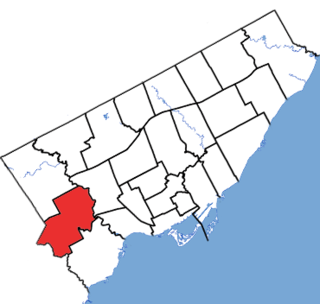
Scarborough is a district of Toronto, Ontario, Canada. It is situated atop the Scarborough Bluffs in the eastern part of the city. Its borders are Victoria Park Avenue to the west, Steeles Avenue and the city of Markham to the north, Rouge River and the city of Pickering to the east, and Lake Ontario to the south. Scarborough was named after the English town of Scarborough, North Yorkshire, inspired by its cliffs.

<span class="mw-page-title-main">Northumberland County, Ontario</span> County in Ontario, Canada

Northumberland County is an upper-tier municipality situated on the north shore of Lake Ontario, east of Toronto in Central Ontario. The Northumberland County headquarters are located in Cobourg.

<span class="mw-page-title-main">Victoria County, Ontario</span> Historical county in Ontario, Canada

The County of Victoria, or Victoria County, was a county in the Canadian province of Ontario. It was formed in 1854 as The United Counties of Peterborough and Victoria, and separated from Peterborough in 1863. In 2001, the county was dissolved and reformed as the city of Kawartha Lakes. Though first opened to settlement in 1821, the area that was encompassed by Victoria County has a history of Indian occupation, first by the Hurons.

<span class="mw-page-title-main">Peterborough County</span> County in Ontario, Canada

Peterborough County is located in Southern Ontario, Canada. The county seat is The City of Peterborough, which is independent of the county.

<span class="mw-page-title-main">Regional Municipality of Niagara</span> Regional municipality in Ontario, Canada

The Regional Municipality of Niagara, also colloquially known as the Niagara Region or Region of Niagara, is a regional municipality comprising twelve municipalities of Southern Ontario, Canada. The regional seat is in Thorold. It is the southern end of the Golden Horseshoe, the largest megalopolis in Canada.

<span class="mw-page-title-main">Simcoe County</span> County in Ontario, Canada

Simcoe County is located in the central portion of Southern Ontario, Canada. The county is just north of the Greater Toronto Area, stretching from the shores of Lake Simcoe in the east to Georgian Bay in the west. Simcoe County forms part of the Greater Golden Horseshoe area, a densely populated and industrialized region, centred on the Greater Toronto Area.

<span class="mw-page-title-main">Dufferin County</span> County in Ontario, Canada

Dufferin County is a county and census division located in Central Ontario, Canada. The county seat is Orangeville, and the current Warden is Wade Mills. The current chief administrative officer is Sonya Pritchard. Dufferin covers an area of 1,486.31 square kilometres (573.87 sq mi), and its population was 61,735 at the time of the 2016 Census.

<span class="mw-page-title-main">Haliburton—Kawartha Lakes—Brock (federal electoral district)</span> Federal electoral district in Ontario, Canada

Haliburton—Kawartha Lakes—Brock is a federal electoral district in central Ontario, Canada, that has been represented in the House of Commons of Canada since 1968.

<span class="mw-page-title-main">Cambridge (federal electoral district)</span> Federal electoral district in Ontario, Canada

Cambridge is a federal electoral district in Ontario, Canada, that has been represented in the House of Commons of Canada since 1979.

<span class="mw-page-title-main">Thompson-Nicola Regional District</span> Regional district in British Columbia, Canada

The Thompson–Nicola Regional District is a regional district in the Canadian province of British Columbia. The Canada 2021 Census population was 143,680 and the area covers 44,449.49 square kilometres. The administrative offices are in the main population centre of Kamloops, which accounts for 78 percent of the regional district's population. The only other city is Merritt; other municipally-incorporated communities include the District Municipalities of Logan Lake, Barriere and Clearwater and the Villages of Chase, Ashcroft, Cache Creek, Clinton and Lytton, and also the Mountain Resort Municipality of Sun Peaks.

<span class="mw-page-title-main">Bobcaygeon</span> Community in Ontario, Canada

Bobcaygeon is a community on the Trent–Severn Waterway in the City of Kawartha Lakes, east-central Ontario, Canada.

<span class="mw-page-title-main">Etobicoke Centre (federal electoral district)</span> Federal electoral district in Ontario, Canada

Etobicoke Centre is a federal electoral district in Ontario, Canada, that has been represented in the House of Commons of Canada since 1979.

<span class="mw-page-title-main">Rural Municipality of St. Clements</span> Rural municipality in Manitoba, Canada

St. Clements is a rural municipality (RM) in Manitoba, Canada. It is located to the north-east of Winnipeg, stretching from East St. Paul and Birds Hill Provincial Park in the south to Lake Winnipeg and Grand Beach Provincial Park to the north. The Red River demarcates the western boundary of the municipality. St. Clements contains the communities of East Selkirk, and Lockport east of the Red River. It almost completely surrounds the Brokenhead 4 Indian reserve, with the exception of a small lakefront on Lake Winnipeg.

King's Highway 35, commonly referred to as Highway 35, is a provincially maintained highway in the Canadian province of Ontario, linking Highway 401 with the Kawartha Lakes, Haliburton, and Algonquin Provincial Park. The highway travels from west of Newcastle, through Lindsay, near Fenelon Falls, Coboconk, Minden Hills, and into Haliburton before terminating at Highway 60 to the west of Algonquin Park. Within those areas, it services the communities of Orono, Cameron, Rosedale, Norland, Moore Falls, Miners Bay, Lutterworth, Carnarvon, Buttermilk Falls, Halls Lake, Pine Springs and Dorset. The winding course of the road, combined with the picturesque views offered along its length, have led some to declare it the most scenic highway in Ontario.

Victoria—Haliburton was a provincial electoral district in central Ontario, Canada which elected members to the Legislative Assembly of Ontario. It was created in 1967 and abolished in 1999 into Haliburton—Kawartha Lakes—Brock and Parry Sound—Muskoka.

King's Highway 121, commonly referred to as Highway 121, was a provincially maintained highway in the Canadian province of Ontario that connected several communities in the cottage country region of Central Ontario on the southern edge of the Canadian Shield. Between Fenelon Falls and Minden, Highway 121 served as an alternative route to Highway 35, which was severely congested during summer weekends. From Minden, the highway branched east to Haliburton Village and thereafter followed the present route of Highway 118 to Highway 28 in Paudash.

References

  1. "Census Profile, 2016 Census: Kawartha Lakes, City [Census subdivision], Ontario". Statistics Canada. Retrieved November 21, 2019.
  2. 1 2 "Census Profile, 2021 Census: Kawartha Lakes, City [Census subdivision], Ontario". Statistics Canada. Retrieved March 19, 2022.
  3. "Kawartha Lakes (Ont) | The Canadian Encyclopedia". thecanadianencyclopedia.ca. Retrieved 2021-06-09.
  4. Rayburn, Alan. Place Names in Ontario. University of Toronto Press. p. 176.
  5. "Municipal Government for Victoria County: A New Beginning - Final Report and Order" (PDF). ODW Ontario Government Documents. 2000-04-19. Archived from the original (PDF) on 2018-04-12. Retrieved 2017-06-07.
  6. "Yes Victoria - Citizens for the de-amalgamation of the city of Kawartha Lakes". Yesvictoria.com. Retrieved 2009-07-12.
  7. 1 2 "Voices of Central Ontario - Historical summary". Voconews.com. Archived from the original on 2009-10-27. Retrieved 2009-08-05.
  8. "Population and dwelling counts: Canada, provinces and territories, census divisions and census subdivisions (municipalities), Ontario". Statistics Canada. February 9, 2022. Retrieved March 27, 2022.
  9. "2021 Community Profiles". 2021 Canadian Census . Statistics Canada. February 4, 2022. Retrieved 2023-10-19.
  10. "2016 Community Profiles". 2016 Canadian Census . Statistics Canada. August 12, 2021. Retrieved 2017-06-07.
  11. "2011 Community Profiles". 2011 Canadian Census . Statistics Canada. March 21, 2019. Retrieved 2012-02-29.
  12. "2006 Community Profiles". 2006 Canadian Census . Statistics Canada. August 20, 2019.
  13. "2001 Community Profiles". 2001 Canadian Census . Statistics Canada. July 18, 2021.
  14. "Lindsay, Ontario Census Profile". 2016 Census of Population . Statistics Canada. Retrieved 2017-06-07.
  15. 1 2 Government of Canada, Statistics Canada (2022-02-09). "Profile table, Census Profile, 2021 Census of Population - Kawartha Lakes, City (CY) [Census subdivision], Ontario". www12.statcan.gc.ca. Retrieved 2023-01-17.
  16. Government of Canada, Statistics Canada (2022-10-26). "Census Profile, 2021 Census of Population". www12.statcan.gc.ca. Retrieved 2023-03-01.
  17. Government of Canada, Statistics Canada (2021-10-27). "Census Profile, 2016 Census". www12.statcan.gc.ca. Retrieved 2023-03-01.
  18. Government of Canada, Statistics Canada (2015-11-27). "NHS Profile". www12.statcan.gc.ca. Retrieved 2023-03-01.
  19. Government of Canada, Statistics Canada (2019-08-20). "2006 Community Profiles". www12.statcan.gc.ca. Retrieved 2023-03-01.
  20. Government of Canada, Statistics Canada (2019-07-02). "2001 Community Profiles". www12.statcan.gc.ca. Retrieved 2023-03-01.
  21. Government of Canada, Statistics Canada (2013-05-08). "2011 National Household Survey Profile - Census subdivision". www12.statcan.gc.ca. Retrieved 2023-01-17.
  22. "Ward Boundaries". City of Kawartha Lakes. Retrieved 16 October 2018.
  23. "Canadian Climate Normals 1981–2000, Janetville". Environment Canada. 25 September 2013.
  24. "Lindsay Frost". Canadian Climate Normals 1981–2010. Environment Canada. Archived from the original on 2020-07-17. Retrieved February 8, 2014.
  25. Algonquin Park and Kawarthas map. MapArt Corporation. 1998.
  26. Order of the Commission, (on Victoria County) (PDF), April 19, 2000, archived from the original (PDF) on May 9, 2008, retrieved 2009-08-05
  27. "Victoria Rail Trail Corridor (VRTC) — City of Kawartha Lakes". City.kawarthalakes.on.ca. Archived from the original on 2016-04-06. Retrieved 2016-03-18.
  28. "Lindsay Transit — City of Kawartha Lakes". City.kawarthalakes.on.ca. Archived from the original on 2016-03-24. Retrieved 2016-03-18.
  29. "Rural Transit" (PDF). City of Kawartha Lakes. Archived from the original (PDF) on March 14, 2014.
  30. "Schedules: Toronto – Haliburton & Toronto – Port Elgin Scheduled Services". TOK Coachlines. 3 July 2019. Retrieved November 21, 2019.
  31. McKechnie, Ian (April 4, 2018). "'A whole chapter is nearly over:' How Lindsay lost its train service". Lindsay Advocate. Retrieved November 21, 2019.
  32. "6104". Cnrphotos.com. Retrieved 21 October 2017.
  33. "2011 Subdivision List" (PDF). Canadian Pacific Railway. p. 9. Archived (PDF) from the original on October 18, 2014.
  34. "Shining Waters Railway". Shiningwatersrailway.com. Archived from the original on 2013-05-04. Retrieved 2016-03-18.
  35. "Kawartha Lakes Car Pooling - Need A Ride?". Kawarthalakesmums.blogspot.ca. 2 February 2014.
  36. "Kawartha Trans Canada Trail - Kawartha Trans Canada Trail". Ktct.ca. Retrieved 2016-03-18.
  37. Krewen, Nick (26 March 2011). "Neil Young: take a look at his life" via Toronto Star.
  38. "Magazine". Thepromoter.ca. Retrieved 2016-03-18.
  39. Municipal Government for Victoria County - A New Beginning (Final Report) (PDF), 2000-04-19, archived from the original (PDF) on 2011-07-21, retrieved 2009-07-22
  40. "Kawartha Lakes (city) community profile". 2006 Census data . Statistics Canada. Retrieved 2011-06-10.