Budj Bim

Last updated

Budj Bim
Mount Eccles
Australia Victoria relief location map.jpg
Red triangle with thick white border.svg
Budj Bim
Highest point
Elevation 178 m (584 ft)
Coordinates 38°3′46″S141°55′32″E / 38.06278°S 141.92556°E / -38.06278; 141.92556
Geography
Location Victoria, Australia
Climbing
Easiest route Lava Canal track
Official nameBudj Bim National Heritage Landscape
Designated20 July 2004
Official nameBudj Bim Cultural Landscape
TypeCultural
Criteriaiii, v
Designated6 July 2019 (43rd session)
Reference no. 1577
Region Asia-Pacific

Budj Bim, also known as Mount Eccles, is a dormant volcano near Macarthur in southwestern Victoria, Australia. It lies within the geologically-defined area known as the Newer Volcanics Province, which is the youngest volcanic area in Australia and stretches from western Victoria to south-eastern South Australia.

Contents

It is situated within the Budj Bim National Park. Budj Bim is the Gunditjmara name, meaning "High Head". The roughly conical peak rises 178 metres (584 ft). The peak is a scoria hill that was thrown up beside a group of three overlapping volcanic craters that now contain Lake Surprise. A line of smaller craters and scoria cones runs to the southeast. Lava flows extend to form a shield volcano and are fed by several lava channels, or "lava canals" as they are known locally. This lava flow, known as the Tyrendarra lava flow, changed the drainage pattern of the region, and created large wetlands.

Large areas to the west and south-west of the mountain have been heritage-listed. The Budj Bim heritage areas include the Tyrendarra Indigenous Protected Area (declared December 2003), the Budj Bim National Heritage Landscape (added to the National Heritage List in July 2004), and the Budj Bim Cultural Landscape (designated a UNESCO World Heritage Site in July 2019).

Formation

The volcano lies within the Newer Volcanics Province, an area defined by its geological features. This covers an area of 15,000 square kilometres (5,800 sq mi), with over 400 small shield volcanoes and volcanic vents, and contains the youngest volcanoes in Australia. [1]

Initial estimates of the age of the eruption of Budj Bim were all "minimum ages", based on swamps that formed some time after the eruption and ranged from 6,000 to 27,000 years BP. [2] Later evidence suggested that the eruption was at least 30,000 BP (using dated sediments in the floor of the Lake Surprise crater [2] ) and could have been as long as 40,000 years ago for the Tyrendarra lava flow. [2] Research published in February 2020 using argon–argon dating, a method of radiometric dating, has dated the eruption at around 36,900 years ago. Specifically, Budj Bim was dated at within 3,100 years either side of 36,900 years BP, and Tower Hill was dated at within 3,800 years either side of 36,800 years BP. Significantly, owing to the presence of human artefacts found under volcanic ash at Tower Hill, this is a "minimum age constraint for human presence in Victoria", and also could be interpreted as evidence for the Gunditjmara oral histories which tell of volcanic eruptions being some of the oldest oral traditions in existence. [3] [4]

The eruptions produced the Tyrendarra lava flow, which flowed in a generally southerly direction into the ocean at Tyrendarra, 50 kilometres (31 mi) away. [5] [6] The flow disrupted the earlier drainage system; to the east the Fitzroy River now flows cleanly between the rocks of the lava flow and the Mount Clay escarpment; to the west its tributary Darlot Creek flows through a more complex landscape of swamps, wetlands and adjacent low-lying land prone to flooding.[ citation needed ]

The peak rises 178 metres (584 ft). [7]

Historic and cultural significance

Crater of Budj Bim Crater of Mount Eccles (Victoria).jpg
Crater of Budj Bim
Lake Surprise, Budj Bim National Park Budj Bim - Mt Eccles National Park, Victoria, Australia 28.jpg
Lake Surprise, Budj Bim National Park

The volcano itself and the surrounding lava flows are of great historic and cultural significance. The creation story of the local Gunditjmara people is based on the eruption of the volcano more than 30,000 years ago. It was via this event that an ancestral creator-being known as Budj Bim was revealed. [8]

The Tyrendarra lava flow changed the drainage pattern of the region, and created large wetlands. [8] From some thousands of years before European settlement (one of five eel trap systems at Lake Condah has been carbon dated to 6,600 years old [8] ), the Gunditjmara people developed a system of aquaculture which channelled the water of the Darlot Creek into adjacent lowlying areas trapping short-finned eels and other fish in a series of weirs, dams and channels. [9] The discovery of these large-scale farming techniques and manipulation of the landscape, highlighted in Bruce Pascoe's best-selling book Dark Emu in 2014, shows that the Indigenous inhabitants were not only hunter gatherers, but cultivators and farmers. [10]

Many Gundjitmara people were moved into Lake Condah Mission, which later became a government-run Aboriginal reserve, which separated "half-caste" children from their parents, who became part of the Stolen Generations.

Protected areas

There are several overlapping protected or heritage-listed areas, two of which encompass Budj Bim itself and the others the lava flows:

Naming Mount Eccles

The mountain was named Mount Eeles in 1836 by Major Thomas Mitchell after William Eeles of the 95th Regiment of Foot who fought with Mitchell in the Peninsular War. A draftsman's error meant that the name was rendered Eccles from 1845. [17]

See also

Related Research Articles

<span class="mw-page-title-main">Budj Bim National Park</span> Protected area in Victoria, Australia

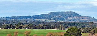
The Budj Bim National Park, formerly known as Mount Eccles National Park, is a national park located in the Western District of Victoria, Australia. The 5,470-hectare (13,500-acre) national park is situated approximately 270 kilometres (170 mi) west of Melbourne and approximately 15 kilometres (9.3 mi) southwest of Macarthur. It derives its name from Budj Bim, formerly Mount Eccles, which is situated in the north-east of the park.

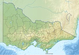
Victoria is the smallest mainland state in Australia. As of 2022 it contained 5,081 separate protected areas with a total land area of 4,012,888 ha.

<span class="mw-page-title-main">Short-finned eel</span> Species of fish

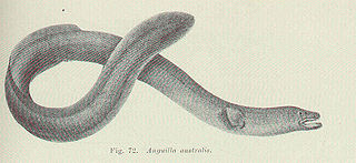
The short-finned eel, also known as the shortfin eel, is one of the 15 species of eel in the family Anguillidae. It is native to the lakes, dams and coastal rivers of south-eastern Australia, New Zealand, and much of the South Pacific, including New Caledonia, Norfolk Island, Lord Howe Island, Tahiti, and Fiji.

<span class="mw-page-title-main">Atherton Tableland</span> Fertile plateau in northern Queensland, Australia

The Atherton Tableland is a fertile plateau, which is part of the Great Dividing Range in Queensland, Australia. It has very deep, rich basaltic soils and the main industry is agriculture. The principal river flowing across the plateau is the Barron River, which was dammed to form the irrigation reservoir named Lake Tinaroo. Unlike many other rural areas, the Tablelands is experiencing a significant growth in population.

<span class="mw-page-title-main">Western District (Victoria)</span> Region in Victoria, Australia

The Western District comprises western regions of the Australian state of Victoria. It is said to be an ill–defined district, sometimes incorrectly referred to as an economic region,. The district is located within parts of the Barwon South West and the Grampians regions; extending from the south-west corner of the state to Ballarat in the east and as far north as Ararat. The district is bounded by the Wimmera district in the north, by the Goldfields district in the east, by Bass Strait and the Southern Ocean in the south, and by the South Australian border in the west. The district is well known for the production of wool. The most populated city in the Western District is the Ballarat region, with 96,940 inhabitants.

<span class="mw-page-title-main">Penshurst, Victoria</span> Town in Victoria, Australia

Penshurst is a town in Victoria, Australia. It is in the Shire of Southern Grampians local government area and is located at the foot of Mount Rouse, an extinct volcano. At the 2006 census, Penshurst had a population of 461. Basic facilities include a hospital with an aged care residency and doctor's surgery, a pub, a hall and two schools – one a State school, the other a Catholic school – the State school has 10 students(2020), the Catholic school 26.

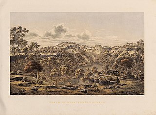
Tower Hill is an inactive volcano on the south-west coast of Victoria, Australia, approximately 275 kilometres (171 mi) west of Melbourne, and 15 kilometres (9 mi) north-west of Warrnambool. The Tower Hill crater is roughly 3 kilometres (2 mi) wide and 80 metres (260 ft) high, with a gradient of between 10% and 80% at the higher points. Within the crater, a series of later volcanic explosions formed a number of scoria cones and spheres, surrounded by a crater lake. Being a giant nested maar, Tower Hill is of international geological significance. The Dhauwurdwurrung name for the volcano is Koroitj.

Framlingham is a rural township located by the Hopkins River in the Western District of Victoria, Australia, about 20 kilometres (12 mi) north-east of the coastal city of Warrnambool. In the 2016 census, the township had a population of 158.

Deen Maar Indigenous Protected Area is an Indigenous Protected Area (IPA) located in south-west Victoria, Australia, on land bounded by the Eumeralla River and Bass Strait. The nearest town is Yambuk.

<span class="mw-page-title-main">Tower Hill Wildlife Reserve</span> Protected area in Victoria, Australia

Tower Hill Wildlife Reserve, officially Tower Hill State Game Reserve, is a protected area located in the Australian state of Victoria, approximately 275 kilometres (171 mi) west of Melbourne, and 15 kilometres (9.3 mi) north-west of Warrnambool. It encompasses the dormant Tower Hill volcano and wetland and is 614 hectares in area.

The Gunditjmara or Gunditjamara, also known as Dhauwurd Wurrung, are an Aboriginal Australian people of southwestern Victoria. They are the traditional owners of the areas now encompassing Warrnambool, Port Fairy, Woolsthorpe and Portland. Their land includes much of the Budj Bim heritage areas. The Kerrup Jmara are a clan of the Gunditjmara, whose traditional lands are around Lake Condah. The Koroitgundidj are another clan group, whose lands are around Tower Hill.

<span class="mw-page-title-main">Newer Volcanics Province</span>

The Newer Volcanics Province is a geological area which is a volcanic field, formed by the East Australia hotspot across south-eastern Australia. It covers an area of 15,000 square kilometres (5,800 sq mi), with over 400 small shield volcanoes and volcanic vents. The area contains the youngest volcanoes in Australia.

<span class="mw-page-title-main">Tyrendarra</span> Town in Victoria, Australia

Tyrendarra is a locality in south west Victoria, Australia. The locality is split between the Shire of Glenelg and the Shire of Moyne local government areas, with most being in the former. It is on the Princes Highway, 338 kilometres (210 mi) south west of the state capital, Melbourne. The Tyrendarra township lies within a bend of Darlot Creek, before it enters the Fitzroy River—which also flows through the locality.

<span class="mw-page-title-main">Condah</span> Town in Victoria, Australia

Condah is a small town in south west Victoria, Australia and is located on the Henty Highway north of Heywood. At the 2006 census, Condah and the surrounding area had a population of 272.

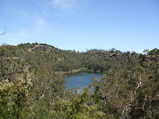
Lake Condah, also known by its Gunditjmara name Tae Rak, is in the Australian state of Victoria, about 324 kilometres (201 mi) west of Melbourne and 20 kilometres (12 mi) north-east of Heywood by road. It is in the form of a shallow basin, about 4 kilometres (2.5 mi) in length and 1 kilometre (0.62 mi) wide.

The Fitzroy River, a perennial river of the Glenelg Hopkins catchment, is located in the Western District of Victoria, Australia.

<span class="mw-page-title-main">Aboriginal Victorians</span> Indigenous people of the Australian state of Victoria

Aboriginal Victorians, the Aboriginal Australians of Victoria, Australia, occupied the land for tens of thousands of years prior to European settlement. Aboriginal people have lived a semi-nomadic existence of fishing, hunting and gathering, and farming eels in Victoria for at least 40,000 years.

<span class="mw-page-title-main">Budj Bim heritage areas</span> UNESCO World Heritage Site in Victoria, Australia

Budj Bim heritage areas includes several protected areas in Victoria, Australia, the largest two being Budj Bim National Heritage Landscape and the Budj Bim Cultural Landscape. Within the latter, there are three Indigenous Protected Areas: the Tyrendarra Indigenous Protected Area, Kurtonitj Indigenous Protected Area, and the Lake Condah Indigenous Protected Area.

Lake Condah Mission, also known as Condah Mission, was established in 1867 as a Church of England mission, approximately 3 kilometres (1.9 mi) from Lake Condah, which was traditionally known as Tae Rak, and about 20 kilometres (12 mi) to 25 kilometres (16 mi) south-east of the small town of Condah. The site of the mission, on 2,000 acres (810 ha) north of Darlot Creek, was formally reserved in 1869, and the Mission continued operations until the reserve was finally revoked in 1951, with most of the land handed over to the Soldiers Settlement Scheme to provide land for white veterans of World War II.

Darlot Creek, also known as Darlots Creek or Darlot's Creek, arises in Lake Condah in south-western Victoria, flows through the wetlands in the Budj Bim heritage areas, past the site of the Lake Condah Mission, and joins the Fitzroy River at the south-eastern corner of the Tyrendarra Nature Conservation Reserve. It lies within the Shire of Glenelg, and is heritage-listed.

References

  1. "Global Volcanism Program". Smithsonian Institution | Global Volcanism Program. Retrieved 18 March 2020.
  2. 1 2 3 Grimes, Ken (2013). "The Ages of Our Volcanoes" (PDF). Archived from the original (PDF) on 8 August 2014. Retrieved 5 August 2014.
  3. Matchan, Erin L.; Phillips, David; Jourdan, Fred; Oostingh, Korien (2020). "Early human occupation of southeastern Australia: New insights from 40Ar/39Ar dating of young volcanoes". Geology. 48 (4): 390–394. Bibcode:2020Geo....48..390M. doi:10.1130/G47166.1. ISSN   0091-7613.
  4. Johnson, Sian (26 February 2020). "Study dates Victorian volcano that buried a human-made axe". ABC News. Australia. Retrieved 9 March 2020.
  5. "Place ID 105678". Australian Heritage Database . Australian Government . Retrieved 28 May 2010.
  6. Parks Victoria (November 2012), Budj Bim – Mt Eccles National Park Visitor Guide (PDF), archived from the original (PDF) on 28 March 2016, retrieved 3 March 2013
  7. Eussen, Dick (March 2011), "Northern Extravaganza", On the Road, p. 64
  8. 1 2 3 4 "National Heritage Places - Budj Bim National Heritage Landscape". Australian Government. Dept of the Environment and Energy. 20 July 2004. Retrieved 30 January 2020. See also attached documents: National Heritage List Location and Boundary Map, and Government Gazette, 20 July 2004.
  9. Machemer, Theresa (22 January 2020). "Australian Bushfires Reveal Hidden Sections of Ancient Aquaculture System". Smithsonian Magazine. Retrieved 30 January 2020.
  10. McNiven, Ian J. (7 February 2017). "The detective work behind the Budj Bim eel traps World Heritage bid". The Conversation. Retrieved 30 January 2020.
  11. "Tyrendarra Indigenous protected area". Australian Government. Dept of the Environment. 5 July 2013. Archived from the original on 20 May 2019. Retrieved 30 January 2020.
  12. Indigenous Land Corporation, Land Purchased VIC, archived from the original on 25 October 2009, retrieved 28 May 2010
  13. "Kurtonitj IPA and Budj Bim Rangers". National Indigenous Australians Agency Vic projects. 11 December 2015. Retrieved 10 March 2020.
  14. "Lake Condah IPA and Budj Bim Rangers". National Indigenous Australians AgencyVic Projects. 11 December 2015. Retrieved 10 March 2020.
  15. "World heritage Places - Budj Bim Cultural Landscape". Australian Government. Dept of the Environment and Energy. 6 July 2019. Retrieved 30 January 2020.
  16. Neal, Matt (6 July 2019). "Ancient Indigenous aquaculture site Budj Bim added to UNESCO World Heritage list". ABC News. Australian Broadcasting Corporation. Retrieved 6 July 2019.
  17. Learmonth, Noel F. (1970). Four Towns and a Survey. Hawthorn Press: Melbourne

Further reading