Hartland is a town in Niagara County, New York, United States. The population was 4,117 at the 2010 census. The town is named after Hartland, Vermont, the homeplace of some early settlers.

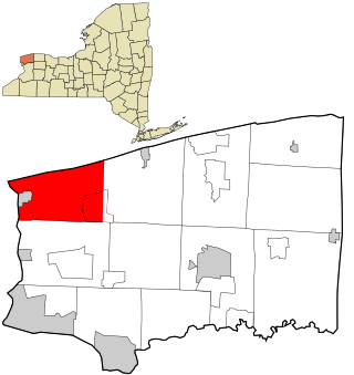
Niagara is a town in Niagara County, New York, United States. At the time of the 2010 census, the town had a total population of 8,378. The town is named after the famous waterfall Niagara Falls.

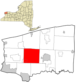
Pendleton is a town on the southern edge of Niagara County, New York, United States. It is east of the city of Niagara Falls and southwest of the city of Lockport. The population was 6,397 at the 2010 census.
Porter is a town in Niagara County, New York, United States. The population was 6,771 at the 2010 census. The town was named after Judge Augustus Porter.

Ransomville is a hamlet located in the Town of Porter in Niagara County, New York, United States. The population was 1,419 at the 2010 census. Portions of the hamlet are also in Town of Wilson and Town of Cambria. Ransomville is north of the City of Niagara Falls and is part of the Buffalo–Niagara Falls Metropolitan Statistical Area.
Royalton is a town in Niagara County, New York, United States. The population was 7,660 at the 2010 census.

Wheatfield is a town in Niagara County, New York, United States. The population was 18,117 at the 2010 census. The name stems from the agricultural use of the town lands, the growing of wheat.

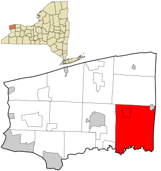
Lewiston is a town in Niagara County, New York, United States. The population was 15,944 at the 2020 census. The town and its contained village are named after Morgan Lewis, a governor of New York.

Lockport is a town in Niagara County, New York, United States. The population was 20,529 at the 2010 census. The name is derived from the series of canal locks on the Erie Canal. The locks lift boats from the lowland of Lake Ontario past the Niagara Escarpment.

Wilson is a town in Niagara County, New York, United States. The population was 5,993 at the 2010 census. The town was named after an early settler, Reuben Wilson, who built and dwelt in a log cabin on the shore of Lake Ontario at the site of what would become the Village of Wilson.

Newfane is a town in Niagara County, New York, United States. The population was 9,666 at the 2010 census.

New York State Route 104 (NY 104) is a 182.41-mile-long (293.56 km) east–west state highway in Upstate New York in the United States. It spans six counties and enters the vicinity of four cities—Niagara Falls, Lockport, Rochester, and Oswego—as it follows a routing largely parallel to the southern shoreline of Lake Ontario, along a ridge of the old shoreline of Glacial Lake Iroquois. The western terminus of NY 104 is an intersection with NY 384 in Niagara Falls, Niagara County, while its eastern terminus is a junction with NY 13 in the town of Williamstown, Oswego County. The portion of NY 104 between Rochester and the village of Webster east of the city is a freeway known as the Keeler Street Expressway west of NY 590 and the Irondequoit–Wayne County Expressway east of NY 590; from Williamson to Oswego, NY 104 is a super two highway.

New York State Route 425 (NY 425) is a north–south state highway in the western portion of New York in the United States. It extends for 23.85 miles (38.38 km) from an interchange with Interstate 290 (I-290) in the town of Tonawanda to an intersection with NY 18 on the shore of Lake Ontario in the village of Wilson. As it heads north, it connects to several regionally important routes, including U.S. Route 62 (US 62) and NY 104. The section between I-290 and the city of North Tonawanda is a four-lane arterial known as the Twin Cities Memorial Highway. North of the city, the route is primarily a two-lane rural highway.
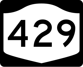
New York State Route 429 (NY 429) is a north–south state highway located entirely within Niagara County, New York, in the United States. It extends for 12.16 miles (19.57 km) from an intersection with NY 265 and NY 384 in North Tonawanda to a junction with NY 104 on the border between the towns of Cambria and Lewiston. Although it is relatively minor in length, the route is regionally important nonetheless as it connects North Tonawanda to some of the county's interior regions. About midway between North Tonawanda and Ridge Road, NY 429 serves the hamlet of Sanborn, where it briefly overlaps with NY 31. At Pekin, a community situated between Sanborn and NY 104, NY 429 descends the Niagara Escarpment.

New York State Route 18 (NY 18) is an east–west state highway in western New York in the United States. It runs parallel to the south shore of Lake Ontario for most of its length between Niagara County and Monroe County. NY 18, which also passes through Orleans County, acts as a northerly alternate to NY 104, another east–west route that parallels NY 18 to the south on Ridge Road. The western terminus of NY 18 is at a complex grade-separated interchange with NY 104 outside the village of Lewiston. Its eastern terminus is at a junction with NY 104 in an area of Rochester known as Eastman Business Park.
New York State Route 93 (NY 93) is a 43.08-mile (69.33 km) state highway in western New York in the United States. The route begins at an intersection with NY 18F in the village of Youngstown and runs in a general northwest–southeast direction across Niagara and Erie counties to its east end at an intersection with NY 5 in the town of Newstead, just south of the village of Akron. NY 93 serves as a connector between several major arterials, including NY 104 in Cambria, NY 31 just west of the city of Lockport, and NY 78 south of the city.
New York State Route 265 (NY 265) is a 19.75-mile (31.78 km) long state highway located in the western part of New York in the United States. NY 265 is a north–south route that roughly parallels the western parts of the Niagara River in Erie County and Niagara County. For much of its southern course, it is more frequently referred to by its longtime name, Military Road, which dates back to 1801 as a road to connect the city of Black Rock and Fort Niagara near Lake Ontario.

New York State Route 270 (NY 270) is a north–south state highway in western New York in the United States. It runs through rural and wooded areas of the town of Amherst in Erie County and the town of Pendleton in Niagara County. The southern terminus of the route is at an intersection with NY 263 south of the hamlet of Getzville. Its northern terminus is at a junction with NY 31 and NY 93 west of the city of Lockport. The entirety of NY 270 is known as Campbell Boulevard, named after New York State Senator William W. Campbell of the Niagara–Orleans district.

New York State Route 182 (NY 182) is a 6.18-mile (9.95 km) state highway in Niagara County, New York, in the United States. It serves as a signed connection between the Whirlpool Rapids Bridge over the Niagara River and the Niagara Falls International Airport east of the city of Niagara Falls. From the bridge, NY 182 runs across the city of Niagara Falls, following several local streets as it makes its way to an intersection with U.S. Route 62 (US 62) in Wheatfield. The route was originally designated as New York State Route 18D in the early 1930s. It gained its current designation on January 1, 1962.