Porter, New York

Last updated

Porter
Town of Porter
Niagara County New York incorporated and unincorporated areas Porter highlighted.svg
Location in Niagara County and the state of New York.
USA New York location map.svg
Red pog.svg
Porter
Coordinates: 43°14′59″N78°59′53″W / 43.24972°N 78.99806°W / 43.24972; -78.99806
Country United States
State New York
County Niagara
Named for Augustus Porter
Government
  Type Town Council
   Town Supervisor John "Duffy" Johnston (R)
   Town Council
Members' List
Area
[1]
  Total37.71 sq mi (97.68 km2)
  Land33.05 sq mi (85.61 km2)
  Water4.66 sq mi (12.07 km2)
Elevation
305 ft (93 m)
Population
 (2010)
  Total6,771
  Estimate 
(2016) [2]
6,595
  Density199.52/sq mi (77.03/km2)
Time zone UTC-5 (Eastern (EST))
  Summer (DST) UTC-4 (EDT)
FIPS code 36-59267
GNIS feature ID0979386
Website https://www.townofporter.net
Location within Niagara County. Niagara-Porter.png
Location within Niagara County.

Porter is a town in Niagara County, New York, United States. The population was 6,771 at the 2010 census. The town was named after Judge Augustus Porter.

Contents

The Town of Porter lies in the northwest corner of Niagara County and is north of the City of Niagara Falls.

History

For thousands of years, the area was inhabited by various cultures of indigenous peoples. At the time of European encounter, this was the territory of the powerful Iroquois Confederacy, based in present-day New York state.

Permanent European-American settlement did not take place until after the American Revolution, about 1801, after most of the Iroquois had been forced to cede their lands to New York and had emigrated across the Niagara River to Upper Canada.

The Town of Porter was created in 1812 from the Town of Cambria, but further development was hindered by the War of 1812. The United States' war with Great Britain first included an embargo of trade with Canada, disrupting the local economy. Warfare along the border continued until 1814.

Geography

According to the United States Census Bureau, the town has a total area of 37.7 square miles (98 km2), of which, 33.2 square miles (86 km2) of it is land and 4.5 square miles (12 km2) of it (12.00%) is water.

The northern boundary of the town is Lake Ontario, and the Western boundary is the Niagara River, which is the international boundary between the United States and Canada. On that western side, the town borders the town of Niagara-on-the-Lake, in Niagara Region, Ontario.

Notable people

Adjacent cities and towns

Major highways in the Town of Porter

Demographics

Historical population
CensusPop.Note
1820 850
1830 1,49075.3%
1840 2,17746.1%
1850 2,45512.8%
1860 2,353−4.2%
1870 2,042−13.2%
1880 2,27811.6%
1890 2,210−3.0%
1900 2,2351.1%
1910 2,65518.8%
1920 2,6821.0%
1930 2,95410.1%
1940 3,36113.8%
1950 4,27627.2%
1960 7,30970.9%
1970 7,4291.6%
1980 7,251−2.4%
1990 7,110−1.9%
2000 6,920−2.7%
2010 6,771−2.2%
2016 (est.)6,595 [2] −2.6%
U.S. Decennial Census [3]

As of the census [4] of 2000, there were 6,920 people, 2,616 households, and 1,935 families residing in the town. The population density was 208.3 inhabitants per square mile (80.4/km2). There were 2,846 housing units at an average density of 85.7 per square mile (33.1/km2). The racial makeup of the town was 97.66% White, 0.48% African American, 0.77% Native American, 0.46% Asian, 0.12% from other races, and 0.52% from two or more races. Hispanic or Latino of any race were 0.66% of the population.

There were 2,616 households, out of which 32.1% had children under the age of 18 living with them, 61.5% were married couples living together, 8.9% had a female householder with no husband present, and 26.0% were non-families. 21.5% of all households were made up of individuals, and 9.0% had someone living alone who was 65 years of age or older. The average household size was 2.60 and the average family size was 3.04.

In the town, the population was spread out, with 24.6% under the age of 18, 7.3% from 18 to 24, 26.4% from 25 to 44, 27.2% from 45 to 64, and 14.6% who were 65 years of age or older. The median age was 40 years. For every 100 females, there were 98.2 males. For every 100 females age 18 and over, there were 93.7 males.

The median income for a household in the town was $50,425, and the median income for a family was $60,373. Males had a median income of $41,985 versus $27,027 for females. The per capita income for the town was $23,951. About 2.2% of families and 4.1% of the population were below the poverty line, including 4.5% of those under age 18 and 3.5% of those age 65 or over.

Communities and locations in Porter

Related Research Articles

<span class="mw-page-title-main">Niagara County, New York</span> County in New York, United States

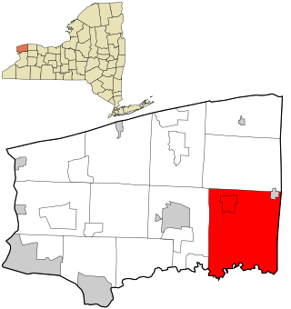
Niagara County is in the U.S. state of New York. As of the 2020 census, the population was 212,666. The county seat is Lockport. The county name is from the Iroquois word Onguiaahra; meaning the strait or thunder of waters. The county is part of the Western New York region of the state.

<span class="mw-page-title-main">Newstead, New York</span> Town in New York, United States

Newstead is the northeasternmost town in Erie County, New York, United States. The population was 8,689 at the 2020 census. The name is reportedly derived from Newstead Abbey in England.

<span class="mw-page-title-main">Hamlin, New York</span> Town in New York, United States

Hamlin is a town in Monroe County, New York, United States. The population was 8,725 at the 2020 census.

<span class="mw-page-title-main">Cambria, New York</span> Town in New York, United States

Cambria is a town in Niagara County, New York, United States. The population was 5,743 at the 2020 census. Cambria is an early name for Wales.

<span class="mw-page-title-main">Hartland, New York</span> Town in New York, United States

Hartland is a town in Niagara County, New York, United States. The population was 4,117 at the 2010 census. The town is named after Hartland, Vermont, the homeplace of some early settlers.

<span class="mw-page-title-main">Niagara, New York</span> Town in New York, United States

Niagara is a town in Niagara County, New York, United States. At the time of the 2010 census, the town had a total population of 8,378. The town is named after the famous waterfall Niagara Falls.

<span class="mw-page-title-main">Olcott, New York</span> CDP in New York, United States

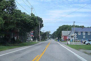
Olcott is a hamlet located in the Town of Newfane in Niagara County, New York, United States. As of the 2010 census, this community population was 1,241. Most locals refer to it as Olcott Beach. It is part of the Buffalo–Niagara Falls Metropolitan Statistical Area.

<span class="mw-page-title-main">Pendleton, New York</span> Town in New York, United States

Pendleton is a town on the southern edge of Niagara County, New York, United States. It is east of the city of Niagara Falls and southwest of the city of Lockport. The population was 6,397 at the 2010 census.

<span class="mw-page-title-main">Ransomville, New York</span> CDP in New York, United States

Ransomville is a hamlet located in the Town of Porter in Niagara County, New York, United States. The population was 1,419 at the 2010 census. Portions of the hamlet are also in Town of Wilson and Town of Cambria. Ransomville is north of the City of Niagara Falls and is part of the Buffalo–Niagara Falls Metropolitan Statistical Area.

<span class="mw-page-title-main">Royalton, New York</span> Town in New York, United States

Royalton is a town in Niagara County, New York, United States. The population was 7,660 at the 2010 census.

<span class="mw-page-title-main">Somerset, New York</span> Town in New York, United States

Somerset is a town in Niagara County, New York, United States. The population was 2,662 at the 2010 census. The town is believed to be named after Somerset, New Jersey, the source of some early settlers.

<span class="mw-page-title-main">Wheatfield, New York</span> Town in New York, United States

Wheatfield is a town in Niagara County, New York, United States. The population was 18,117 at the 2010 census. The name stems from the agricultural use of the town lands, the growing of wheat.

<span class="mw-page-title-main">Youngstown, New York</span> Village in New York, United States

Youngstown is a village in Niagara County, New York, United States. The population was 1,935 at the 2010 census. It is part of the Buffalo–Niagara Falls Metropolitan Statistical Area.

<span class="mw-page-title-main">Wilson (village), New York</span> Village in New York, United States

Wilson is a village in Niagara County, New York, United States. The population was 1,264 at the 2010 census. The village is said to be named after Luther Wilson. It is part of the Buffalo–Niagara Falls Metropolitan Statistical Area.

<span class="mw-page-title-main">Lewiston, New York</span> Town in New York, United States

Lewiston is a town in Niagara County, New York, United States. The population was 15,944 at the 2020 census. The town and its contained village are named after Morgan Lewis, a governor of New York.

<span class="mw-page-title-main">Lockport (town), New York</span> Town in New York, United States

Lockport is a town in Niagara County, New York, United States. The population was 20,529 at the 2010 census. The name is derived from the series of canal locks on the Erie Canal. The locks lift boats from the lowland of Lake Ontario past the Niagara Escarpment.

<span class="mw-page-title-main">Wilson, New York</span> Town in New York, United States

Wilson is a town in Niagara County, New York, United States. The population was 5,993 at the 2010 census. The town was named after an early settler, Reuben Wilson, who built and dwelt in a log cabin on the shore of Lake Ontario at the site of what would become the Village of Wilson.

<span class="mw-page-title-main">Newfane, New York</span> Town in New York, United States

Newfane is a town in Niagara County, New York, United States. The population was 9,666 at the 2010 census.

<span class="mw-page-title-main">New York State Route 93</span> State highway in western New York, US

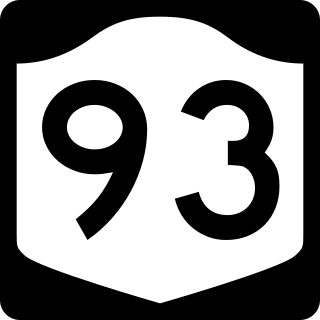
New York State Route 93 (NY 93) is a 43.08-mile (69.33 km) state highway in western New York in the United States. The route begins at an intersection with NY 18F in the village of Youngstown and runs in a general northwest–southeast direction across Niagara and Erie counties to its east end at an intersection with NY 5 in the town of Newstead, just south of the village of Akron. NY 93 serves as a connector between several major arterials, including NY 104 in Cambria, NY 31 just west of the city of Lockport, and NY 78 south of the city.

<span class="mw-page-title-main">New York State Route 18F</span> Highway in New York

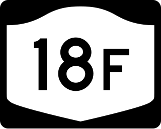
New York State Route 18F (NY 18F) is a 9.80-mile (15.77 km) long state highway in northwestern Niagara County, New York, in the United States. The southern terminus of the route is at an interchange with NY 104 and the Niagara Scenic Parkway just east of the village of Lewiston. The northern terminus is at an intersection with NY 18 near Four Mile Creek State Park in Porter. NY 18F parallels NY 18 for most of its alignment, taking a more westerly course than its parent. NY 18F is the only remaining suffixed route of NY 18.

References

  1. "2016 U.S. Gazetteer Files". United States Census Bureau. Retrieved July 5, 2017.
  2. 1 2 "Population and Housing Unit Estimates" . Retrieved June 9, 2017.
  3. "Census of Population and Housing". Census.gov. Retrieved June 4, 2015.
  4. "U.S. Census website". United States Census Bureau . Retrieved January 31, 2008.

43°14′59″N78°59′53″W / 43.24972°N 78.99806°W / 43.24972; -78.99806