Escambia County is the westernmost and oldest county in the U.S. state of Florida. It is in the state's northwestern corner. At the 2020 census, the population was 321,905. Its county seat and largest city is Pensacola. Escambia County is included within the Pensacola-Ferry Pass-Brent, Florida, Metropolitan Statistical Area. The county population has continued to increase as the suburbs of Pensacola have developed.

Santa Rosa County is a county located in the northwestern portion of the U.S. state of Florida. As of 2020, the population is 188,000. The county seat is Milton, which lies in the geographic center of the county. Other major communities within Santa Rosa County are Navarre, Pace, and Gulf Breeze. Navarre is the most populated community with a population of approximately 45,000 residents. Santa Rosa County is included in the Pensacola Metropolitan Statistical Area, which also includes Escambia County.

Century is a town in Escambia County, Florida, United States. Per the 2020 census, the population was 1,713. It is part of the Pensacola–Ferry Pass–Brent Metropolitan Statistical Area.

Molino is a census-designated place (CDP) in Escambia County, Florida, United States. The population was 1,277 at the 2010 census. It is part of the Pensacola–Ferry Pass–Brent Metropolitan Statistical Area.

Pace is an unincorporated community in Santa Rosa County, Florida. It is the second largest community in Santa Rosa County, and is a part of the Pensacola Metropolitan Statistical Area. Pace has experienced exponential growth, and has evolved from a small, rural community to a thriving bedroom community of Pensacola with growing residential and commercial options. As of the 2020 United States census, the population was 24,684. From 2000 to 2010, the Pace CDP population growth percentage was 171.1%, and from 2010 to 2020, the population growth percentage was 22.8%.

Perdido River, historically Rio Perdido (1763), is a 65.4-mile-long (105.3 km) river in the U.S. states of Alabama and Florida; the Perdido, a designated Outstanding Florida Waters river, forms part of the boundary between the two states along nearly its entire length and drains into the Gulf of Mexico. During the early 19th century it played a central role in a series of rotating boundary changes and disputes among France, Spain, Great Britain, and the United States.

The Florida Panhandle is the northwestern part of the U.S. state of Florida. It is a salient roughly 200 miles long, bordered by Alabama on the north and the west, Georgia on the north, and the Gulf of Mexico to the south. Its eastern boundary is arbitrarily defined. It is defined by its southern culture and rural geography relative to the rest of Florida, as well as closer cultural links to French-influenced Louisiana, Mississippi, and Alabama. Its major communities include Pensacola, Navarre, Destin, Panama City Beach, and Tallahassee.
Tarkiln Bayou Preserve State Park is a 4,290-acre (17.4 km2) preserve, a unit of Florida State Park located 10 miles (16 km) southwest of Pensacola, in northwestern Florida. It is home to four species of endangered pitcher plants, as well as other rare and endangered plant species. The rare, carnivorous white–top pitcher plant is unique to the Gulf Coast and found only between the Apalachicola and Mississippi rivers. Almost 100 other rare plants and animals depend on the wet prairie habitat, including the alligator snapping turtle, sweet pitcher plant, and Chapman's butterwort. Tarkiln Bayou Preserve State Park is located in Escambia County about 1.5 miles (2.4 km) south of the intersection of U.S. Hwy. 98 and State Road 293.

Perdido Key is an unincorporated community in Escambia County, Florida located between Pensacola, Florida and Orange Beach, Alabama. The community is located on and named for Perdido Key, a barrier island in northwest Florida and southeast Alabama. "Perdido" means "lost" in the Spanish and Portuguese languages. The Florida district of the Gulf Islands National Seashore includes the east end of the island, as well as other Florida islands. No more than a few hundred yards wide in most places, Perdido Key stretches some 16 miles (26 km) from near Pensacola to Perdido Pass Bridge near Orange Beach.

The Pensacola metropolitan area is the metropolitan area centered on Pensacola, Florida. It is also known as the Pensacola-Ferry Pass-Brent Metropolitan Statistical Area, a metropolitan statistical area (MSA) used for statistical purposes by the United States Census Bureau and other agencies. The Pensacola Standard Metropolitan Statistical Area was first defined in 1958, with Pensacola as the principal city, and included Escambia and Santa Rosa counties. The SMA was renamed Pensacola-Ferry Pass-Brent MSA in 2003, with the unincorporated census-designated places Ferry Pass and Brent added as principal cities. The population of the MSA in the 2020 census was 511,502.

U.S. Route 29 in the State of Florida is the westernmost south-to-north U.S. route in the state. It runs 43.6 miles (70.2 km) from downtown Pensacola north to the Alabama state line entirely within Escambia County. US 29 runs as a four-lane highway through much of the panhandle, becoming six lanes through and near several towns. The highway's hidden state road designation is entirely State Road 95.
The Northwest Florida Water Management District (NWFWMD) stretches from the St. Marks River Basin in Jefferson County to the Perdido River in Escambia County. The District is one of five water management districts in Florida created by the Water Resources Act of 1972. The District has worked for decades to protect and manage water resources in a sustainable manner for the continued welfare of people and natural systems across its 16-county region. It serves Bay, Calhoun, Escambia, Franklin, Gadsden, Gulf, Holmes, Jackson, Leon, Liberty, Okaloosa, Santa Rosa, Wakulla, Walton, Washington and western Jefferson County.
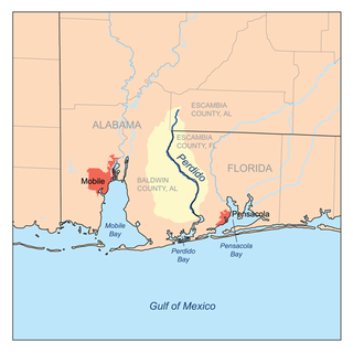
Perdido Bay is a bay at the mouth of and draining the Perdido River, a designated Outstanding Florida Waters river, in Baldwin County, Alabama and Escambia County, Florida, United States. It is essentially a coastal lagoon enclosed by barrier islands, with an inlet, Perdido Pass.

State Road 298, known locally as Lillian Highway, is a mostly east–west thoroughfare in Pensacola, Florida. It runs from its intersection with U.S. Highway 98 and Dog Track Road, skirting Perdido Bay on its way east to its terminus at the West Pensacola spur of SR 295. SR 298 passes under the mainline of SR 295 without an interchange. It serves as a major route through the communities of Myrtle Grove and West Pensacola.
Barrineau Park is an unincorporated community in Escambia County, Florida, United States. It is approximately 5 miles (8.0 km) west of Molino and a few miles from the Perdido River. It is a rural community of low hills, farms, creeks and woods.

The Escambia County Sheriff's Office (ECSO) or Escambia Sheriff's Office (ESO) is the primary law enforcement agency of unincorporated Escambia County and the town of Century. ECSO is headed by a sheriff, who serves a four-year term and is elected in a partisan election. The current sheriff is Chip W. Simmons.
McDavid is an unincorporated community in Escambia County, Florida, United States. The community is part of the Pensacola – Ferry Pass – Brent, Florida Metropolitan Statistical Area. The ZIP Code for McDavid is 32568.
Brownsville is an unincorporated community in Escambia County, Florida, United States. It is located within the census-designated place of West Pensacola. It was enumerated as a Census-Designated Place in 1960, when the population recorded was 38,417. The ZIP code for Brownsville is 32505.
Floridatown is a census-designated place located in Santa Rosa County, Florida. It is now considered to be a neighborhood within Pace. The population was 244 as of the 2010 census.

Millview is an unincorporated community located along Perdido Bay in Escambia County, Florida, United States.