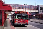
OC Transpo is the organisation that operates and plans public transport in the city of Ottawa. OC Transpo's system includes bus rapid transit, light rail, conventional bus routes, and door-to-door paratransit.

Buffalo Metro Rail is the public transit rail system in Buffalo, New York, operated by the Niagara Frontier Transportation Authority (NFTA). The system consists of a single, 6.4-mile-long (10.3 km) light rail line that runs for most of the length of Main Street from KeyBank Center in Canalside to the south campus of the University at Buffalo in the northeast corner of the city. The first section of the line opened in October 1984; the current system was completed in November 1986. In 2023, the system had a ridership of 2,433,300, or about 6,600 per weekday as of the fourth quarter of 2023.

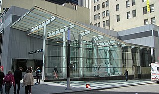
Charles/MGH station is a rapid transit station on the MBTA Red Line, elevated above Charles Circle on the east end of the Longfellow Bridge in the West End neighborhood of Boston, Massachusetts. The station is named for Charles Circle and the adjacent Massachusetts General Hospital (MGH) campus. It has two side platforms, with a glass-walled headhouse structure inside Charles Circle. Charles/MGH station is fully accessible.

JFK/UMass station is a Massachusetts Bay Transportation Authority (MBTA) intermodal transfer station, located adjacent to the Columbia Point area of Dorchester, Boston, Massachusetts. It is served by the rapid transit Red Line; the Greenbush Line, Kingston/Plymouth Line, and Middleborough/Lakeville Line of the MBTA Commuter Rail system, and three MBTA bus routes. The station is named for the John F. Kennedy Presidential Library and Museum and the University of Massachusetts Boston, both located nearby on Columbia Point.
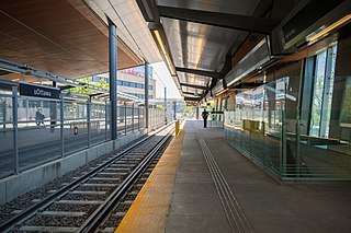
uOttawa is a light rail transit (LRT) station on the O-Train Confederation Line, located on the University of Ottawa campus.
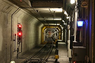
The Market Street subway is a two-level subway tunnel that carries Muni Metro and BART trains under Market Street in San Francisco, California. It runs under the length of Market Street between Embarcadero station and Castro station. The upper level is used by Muni Metro lines and the lower level is used by BART lines. BART does not run through the whole subway; it turns south and runs under Mission Street southwest of Civic Center/UN Plaza station. The northeastern end of the BART level is connected to the Transbay Tube. On the Muni Metro level, the southwestern end of the Market Street subway connects to the much-older Twin Peaks Tunnel, and the northeastern end connects to surface tracks along the Embarcadero.
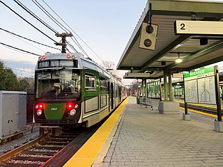
Riverside station is a Massachusetts Bay Transportation Authority (MBTA) Green Line light rail station located in the Auburndale village of Newton, Massachusetts. It is the western terminal of the Green Line D branch service. The station is located near the interchange of Interstate 95 and the Massachusetts Turnpike (I-90) and serves as a regional park and ride station. West of the station is Riverside Yard, the main maintenance facility and largest storage yard for the Green Line. The station is fully accessible.

The Trillium Line, also called O-Train Line 2, is a diesel light rail transit (DLRT) service in Ottawa, Ontario, Canada, operated by OC Transpo. The line has been closed since May 2020 for service expansion.
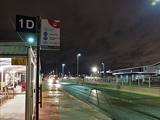
Baseline is a public transit station directly across from the main campus of Algonquin College in Ottawa's west end, near the intersection of Woodroffe Avenue and Baseline Road. Many Algonquin College students and Centrepointe residents use this station to get to various points in the city, and to and from the college. Several residential and business areas such as Centrepointe and College Square are also served by this station.

Balboa Park station is a Bay Area Rapid Transit (BART) station and Muni Metro complex in the Mission Terrace neighborhood of San Francisco, California, located near the eponymous Balboa Park. It is an intermodal hub served by four BART routes, three Muni Metro lines, and a number of Muni bus routes. The station complex also includes two rail yards, Cameron Beach Yard and Green Light Rail Center, where Muni maintains Muni Metro trains and heritage streetcars. BART uses a below-grade island platform on the west side of the complex; Muni Metro routes use several smaller side platforms located on surface-level rail loops around the yards.

The Alvarado Transportation Center (ATC) is a multimodal transit hub located at 100 1st Street SW in Downtown Albuquerque, New Mexico. The complex was built as a hub for Albuquerque's regional transit system and as a replacement for Albuquerque's previous bus depot and train station. The center serves ABQ RIDE, Amtrak, Greyhound Lines, and the New Mexico Rail Runner Express commuter rail line.

South Norwalk station is a commuter rail station in Norwalk, Connecticut, served by the Metro-North Railroad New Haven Line and CTrail Shore Line East services. It is owned and managed by the Norwalk Transit District. The station is the point where the New Haven Line's Danbury Branch connects to the Northeast Corridor, as well as a peak-hour terminal for some express trains. Just east of the station are the South Norwalk Railroad Bridge and SoNo Switch Tower Museum.

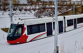
Edmonton Light Rail Transit, commonly referred to as the LRT, is a light rail system in Edmonton, Alberta. Part of the Edmonton Transit Service (ETS), the system has 29 stations on three lines and 37.4 km (23.2 mi) of track. As of 2018, it was number seven on a list of the busiest light rail transit systems in North America, with over 113,000 daily weekday riders.
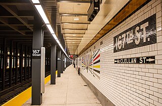
The 167th Street station is a local station on the IND Concourse Line of the New York City Subway. Located at the intersection of 167th Street and Grand Concourse in the Highbridge and Concourse neighborhoods of the Bronx, it is served by the D train at all times except rush hours in peak direction and the B train during rush hours.

Metrolinx is a Crown agency of the Government of Ontario that manages and integrates road and public transport in the Greater Toronto and Hamilton Area (GTHA), which comprises much of Ontario's Golden Horseshoe region. Headquartered at Union Station in Toronto, the agency was created as the Greater Toronto Transportation Authority on June 22, 2006. The agency adopted its present name as a brand name in 2007 and eventually as the legal name in 2009.

Light rail is a commonly used mode of public transit in North America. The term light rail was coined in 1972 by the Urban Mass Transportation Administration to describe new streetcar transformations which were taking place in Europe and the United States. The Germans used the term Stadtbahn, which is the predecessor to North American light rail, to describe the concept, and many in UMTA wanted to adopt the direct translation, which is city rail. However, in its reports, UMTA finally adopted the term light rail instead.

Palo Alto station is an intermodal transit center in Palo Alto, California. It is served by Caltrain regional rail service, SamTrans and Santa Clara VTA local bus service, Dumbarton Express regional bus service, the Stanford University Marguerite Shuttle, and several local shuttle services. Palo Alto is the second-busiest Caltrain station after San Francisco, averaging 7,764 weekday boardings by a 2018 count. The Caltrain station has two side platforms serving the two tracks of the Peninsula Subdivision and a nearby bus transfer plaza.
The Dey Street Passageway or Dey Street Concourse is a 350-foot-long (110 m) underground passageway in Manhattan, New York City, built as part of the Fulton Center project to rehabilitate the Fulton Street station complex and improve connectivity in Lower Manhattan. The Dey Street Passageway lies under Dey Street in Lower Manhattan, between Broadway in the eastern end, and Church Street in its western end.

The O-Train is a light rail rapid transit system in Ottawa, Ontario, Canada, operated by OC Transpo. The O-Train system has two lines, the electrically-operated Confederation Line and the diesel-operated Trillium Line. Since May 2020, Stage 2 construction has temporarily shut down Line 2, with replacement bus service being offered at all stations. When Line 2 reopens in 2024, it will extend southward to Limebank station and incorporate five newly constructed stations, as well as an additional line linking Line 2 to Ottawa International Airport which will replace the current bus service from route 97. By 2026, expansions along Line 1 and the construction of Line 3 stations in the west end are expected to be complete, bringing the system's length to 64.5 km (40.1 mi), four lines and 41 stations. The O-Train network is fully grade separated and does not have any level crossings with roads.

Central Station is a light rail station in Kitchener, Ontario, Canada, which is planned to be expanded into an intermodal transit terminal. As of 2021, it consists of an Ion light rail stop and Grand River Transit bus stops. The site is planned to also include a train station served by Via Rail and GO Transit, and an intercity bus terminal.