Cartography of Jerusalem

Last updated
The cartography of Jerusalem prior to modern surveying techniques is focused only on the Old City, shown here. The expansion of the city from the mid-nineteenth century coincided with the production of the first modern map (see the Ordnance Survey map in the list below). JERUSALEM THE OLD CITY & THE TEMPLE MOUNT.JPG
The cartography of Jerusalem prior to modern surveying techniques is focused only on the Old City, shown here. The expansion of the city from the mid-nineteenth century coincided with the production of the first modern map (see the Ordnance Survey map in the list below).

The cartography of Jerusalem is the creation, editing, processing and printing of maps of Jerusalem from ancient times until the rise of modern surveying techniques. Most extant maps known to scholars from the pre-modern era were prepared by Christian mapmakers for a Christian European audience. [1] [2]

Contents

Maps of Jerusalem can be categorised between original factual maps, copied maps and imaginary maps, the latter being based on religious books. [3] The maps were produced in a variety of materials, including parchment, vellum, mosaic, wall paintings and paper. [4] All maps marking milestones in the cartography of Jerusalem are listed here following the cartographic histories of the city, from Titus Tobler and Reinhold Röhricht's studies in the 19th century to those of Hebrew University of Jerusalem academics Rehav Rubin and Milka Levy-Rubin in recent decades. The article lists maps that progressed the cartography of Jerusalem before the rise of modern surveying techniques, showing how mapmaking and surveying improved and helped outsiders to better understand the geography of the city. Imaginary maps of the ancient city and copies of existing maps are excluded.

The Madaba Map discovered in modern-day Jordan is the oldest known map of Jerusalem, [4] in the form of a mosaic in a Greek Orthodox Church. At least 12 maps survive from the Catholic mapmakers of the Crusades; they were drawn on vellum and mostly show the city as a circle. [4] [5] Approximately 500 maps are known between the late-1400s and the mid-1800s; the significant increase in number is due to the advent of the printing press. The first printed map of the city was drawn by Erhard Reuwich and published in 1486 by Bernhard von Breydenbach in his Peregrinatio in Terram Sanctam, based on his pilgrimage of 1483. [4] Few of the mapmakers had travelled to Jerusalem – most of the maps were either copies of others' maps or were imaginary (i.e. based on reading of religious texts) in nature. [6] The first map based on actual field measurements was published in 1818 by the Czech mapmaker Franz Wilhelm Sieber. [4] [7] The first map based on modern surveying techniques was published by Charles Wilson in 1864–65 for the British Ordnance Survey. [4] [8]

Notable maps of Jerusalem

Early religious (6th–7th centuries)

DateTitle Cartographer CommentsImage
c. 560–565 [9] Madaba Map unknownThe earliest known map of Jerusalem, and oldest known geographic floor mosaic in art history. [10] The mosaic was discovered in 1884, but no research was carried out until 1896. [10] [11] It has been heavily used for the localisation and verification of sites in Byzantine Jerusalem, such as the Damascus Gate, the Lions' Gate, the Golden Gate, the Zion Gate, the Church of the Holy Sepulchre and the Tower of David; in 1967, excavations revealed The Nea church and the Cardo Maximus (the road depicted in the map that runs through the centre of Jerusalem) in the locations suggested by the Madaba Map. [12] [13] Madaba map.jpg
c. 680 [14] Arculf map Arculf via Adomnán Ground plan from the first book of De Locis Sanctis . The map shows relevant Christian sites in relation to each other. [14] The earliest known manuscript dates from the ninth century, two centuries after Arculf's journey. [15] It was the oldest known map of Jerusalem prior to the discovery of the Madaba map. [16] Arculf spent nine months in Jerusalem before transmitting the story of his travels to Adomnán, for the benefit of other pilgrims. Adomnán wrote that Arculf had drawn his maps and plans on wax tablets. [15] Not all the known manuscripts of the text include the maps and plans. [15] Arculf De Locis Sanctis Jerusalem.jpg
c. 785 Umm ar-Rasas mosaics unknownPart of the mosaic floor at the center of the Umm ar-Rasas Byzantine St. Stephen's church depicting Jerusalem, identifying it as Hagia Polis in Greek, the Holy City. The mosaic floor depicts eight cities west of the Jordan River, Jerusalem being the first one, while the right side depicting seven cities east of the Jordan River, and the inner corners depicting cities of the Nile Delta. The entire mosaic appears to have been completed during the Abbasid Caliphate. [17] Umm ar-Rasas Church of St. Stephen Jerusalem 2785.jpg

Crusader maps (12th–14th centuries)

The Crusader maps were first catalogued in the late 19th century by Reinhold Röhricht; [18] he catalogued eight maps, which he labelled (1) Brüssel, (2) Copenhagen, (3) Florenz?, (4) Haag, (5) München (6) St. Omer, (7) Paris and (8) Stuttgart. [19] Map (3) was later identified as the Uppsala map, [18] and map (5) is the Arculf map (see section above). [16] [19] Today, at least 12 such maps are known. [4] [5]

A majority of the crusader maps are known as "round maps”, showing the city as a perfect circle, considered to symbolize the “ideal city”. [20] These maps have unique features, but they are all related; it is likely that there was an original prototype from which these maps were derived. [21] Four of the earlier round maps are associated with the Gesta Francorum ; it has been suggested that illustrating this text may have been the purpose of the prototype round map. [22] All the round maps are east-facing, like the T and O maps of the world to which they show a number of similarities, have five gates in non-symmetrical locations, and show the actual basic street plan of Jerusalem. [21] The maps show two central roads in the shape of a cross, likely to represent the Roman cardo and decumanus, with an additional street leading to Yehoshafat's Gate and – in most but not all – a fourth street starting at St. Stephen's Gate. [21]

DateTitle Cartographer CommentsImage
1140s [23] Cambrai map unknownFrom the Médiathèque d'agglomération de Cambrai. It is considered to be the most accurate of the Crusader maps, [24] highly likely to be based on direct knowledge. [23] The walls of the city are shown in the shape of a rhomboid, from an elevation perspective. [23] The map provides names for gates and towers, shows some main streets, and marks the main buildings and churches. [23] The Holy Sephulchre is shown in its new Crusader form and labelled "Anastasis", the Al Aqsa Mosque is labelled "Domus Militum Templi", and numerous eastern churches are shown – Mar Saba, Chariton's lavra, St George, St Abraham, St Bartholomew, and the Jacobite church of St Mary Magdalene. [24] Cambrai map.jpg
c. 1150 [25] Brussels mapunknownA round map in decorative style with miniatures of pilgrims. [26] The map is from the Royal Library of Belgium, dated to the mid 12th century. [27] Brussels map.png
c. 1170 [25] Hague mapunknownThe most famous of eleven round Crusader maps. [28] The map is in decorative style with miniatures of fighting crusaders. [26] Plan of Jerusalem, 12th Century. ca. 1200.jpg
1100s [29] Paris mapunknownA round map with detailed pictures of buildings. [26] It is one of four crusader maps with a connection to the Gesta Francorum , [30] from a copy of the Liber Floridus held in the Bibliothèque nationale de France it carries part of the text from the Gesta Francorum around and within the map. [30] Thought to be from the 12th century. [29] Paris map.jpg
1100s [18] Uppsala mapunknownAnother of the four round maps with a connection to the Gesta Francorum . [30] It is located in a manuscript between Robert the Monk's Historia Hierosolymitana and the Gesta Francorum (presented as the 10th book of the Historia Hierosolymitana), [31] held in the Uppsala University Library. It was rediscovered in 1995. [18] Upsala map.jpg
1100s [19] Saint Omer mapunknownA round map from a copy of the Gesta Francorum held in the French town of Saint-Omer. [19] St omar map.jpg
c. 1200London mapunknownFrom a miscellaneous set of manuscripts in the British Library. It is another of the four round maps with a connection to the Gesta Francorum ; it carries part of the text from the Gesta Francorum around and within the map. [30] London Crusader Map of Jerusalem.jpg
c. 1200Codex Harley mapunknownFrom the British Library's Harleian Library. The map represents the itinerary of a pilgrim, with Jerusalem as its highlight. [32] It is unrelated to the other round maps, as it has only four symmetrical gates, and has no crossroads. The map "has no pretense of accuracy", but rather presents "the author's conception of his journey". [32] Codex Harley Crusader map of Jerusalem.jpg
c. 1200sMontpellier mapunknownHeld in the University of Montpellier library. The map is north-facing, is the only crusader map in a square shape, and includes a description of crusader forces arrayed outside the walls of the city. [24] The sites identified on the map – various sites of the Passion of Jesus, the site where Helena found the cross, and the navel of the earth – are in locations "only remotely related to reality". [24] Montpellier Crusader map of Jerusalem.png
c. 1250 [33] Matthew Paris map Matthew Paris Pilgrimage map from Chronica Majora . It is likely to have been based on a set of itineraries. [33] Map-Jerusalem.jpg
1300s [34] Copenhagen mapunknownA round map in northern European style. [26] The annotations were probably made by Haukr Erlendsson. [34] Copenhagen2 map.jpg
1300s [35] Stuttgart mapunknownA round map from the Württembergische Landesbibliothek. It was originally acquired from the Zwiefalten Abbey, and is thought to be from the 14th century. [35] Stutgart map.jpg
1321 [36] Sanudo-Vesconte map Pietro Vesconte Published in Liber Secretorum. The work was intended to rekindle the spirit of the crusades. It is considered likely that the cartography dates from prior to the Crusaders' final loss of Jerusalem in 1244. [37] The map focuses on the city's water supply. [36] The map ”has no obvious precursor” in map form; it is thought to have used texts from Josephus and Burchard of Mount Sion. [36] 1321 map of Jerusalem from Sanudo-Vesconte's Liber Secretorum.jpg

Notable 15th–18th century maps

DateTitle Cartographer CommentsImage
1472 [38] Comminelli map Pietro del Massaio Map prepared for Alfonso II of Naples. It was one of a number of maps to accompany Jacopo d'Angelo's Latin translation of Ptolemy's Geography , copied by French copyist Hugo Comminelli and illustrated by the Florentine cartographer Pietro del Massaio. [38] It is considered a "realistic" map, but includes a number of imaginary historical elements. Contemporary elements in the map include the Muristan, labelled "Hospicium Peregrinorum" and the Dome of the Rock with an Islamic crescent on top, labelled "Templum Solomonis", whilst imaginary elements include the centre of the world ("mundi medium") located at the Holy Sepulchre. [39] 1472 map of Jerusalem by Hugo Comminelli and Pietro del Massaio 01.jpg
1475 [40] Rieter map Sebald Rieter Considered to be the first known "Franciscan map" of Jerusalem. The map depicts Jerusalem from the viewpoint of the Mount of Olives. [40] The Franciscan order, which had been appointed by the Vatican as custodians of the Holy Places in 1342, was devoted to spreading knowledge of the city. Many of the city's primary buildings are drawn "fairly accurately". [40] Rieter and his companion Hans Tucher were pilgrims from Nuremberg; the text is a mixture of Latin and Italian. [41] The al-Aqsa Mosque is labeled as the "Church of the Saracens" (Ecclesie Sarazeni). [42] 1475 map of Jerusalem by Sebald Rieter.jpg
1483–86 [4] Reuwich map Erhard Reuwich First printed map of Jerusalem. It was published by Bernhard von Breydenbach in Mainz (where the printing press had been invented) in his Peregrinatio in Terram Sanctam . [4] The map is set "vastly out of scale" in a map of the wider Holy Land. [43] Peregrinatio in terram sanctam Jerusalem map in color.jpg
1578 [44] de Angelis mapFriar Antonino de AngelisThe most influential Franciscan map of Jerusalem, copied by numerous subsequent mapmakers. The map, engraved by Mario Cartaro and printed at the Santa Maria in Ara Coeli in Rome, was rediscovered in 1981. [44] [45] De Angelis map of Jerusalem.png
1608 [46] Willenberg map Johann Willenberg Published in Kryštof Harant's Journey from Bohemia to the Holy Land, by way of Venice and the Sea . It was the first Czech travelogue of Palestine; Harant measured the Holy Sepulchre in detail, comparing it to Prague's St. Vitus Cathedral. [46] Jeruzalem, JW.jpg
1620 [47] Amico map Bernardino Amico A corrected version of the de Angelis map. The map was made by de Angelis's successor as the official Franciscan mapmaker. The work was published in 1620 in a detailed survey of the Holy Land Trattato delle Piante & Imagini de Sacri Edificii di Terra Santa, disegnate in Gierusalemme [Treatise on the Plans & Images of Sacred Buildings of the Holy Land, drawn in Jerusalem]. [44] [47] La vera e reale cita di Gierusalem come si trova ogi.jpg
1621 [48] Deshayes map Louis Deshayes The first printed map to map to present the city from a vertical bird's-eye view. The work was published in 1624, in Voyage du Levant, fait par le commandement du roi en 1621, detailing Deshayes' journey to the region under the orders of Louis XIII. [48] Hierusalem - Deshayes Louis Baron De Courmenin - 1631.jpg
1634 [49] Munich mapunknown Proskynetarion produced in Jerusalem and Mar Saba. It is the oldest known 17th and 18th century Greek Orthodox map of Jerusalem. [50] The author is identified as a Jerusalem-based monk from Crete named Akakios (Ἀκακίου ἱερομοναχοῦ τοῦ Κρητὸς). [51] Like most such Greek Orthodox maps, the Church of the Holy Sepulchre is a central and outsized component of the map. [52] The map is a south-facing birds eye-view of an oval-shaped Jerusalem, showing realistic depictions of a number of the city's main buildings. The Islamic crescent is shown on top of a number of structures, including the Dome of the Rock. [53] 1634 Munich map of Jerusalem, produced in Jerusalem and Mar Saba.jpg
1728 [54] De-Pierre Map De PierreConsidered to be a comparatively accurate depiction, with an unusual focus on Christian monasteries in and around Jerusalem. [54] The map was drawn by an otherwise unknown pilgrim from Vienna, signed De Pierre Eques S.S. Sepulchri. It is likely to have been copied from a map published in the same year by Patriarch Chrysanthus of Jerusalem. [55] The map was dedicated to empress Elisabeth Christine, the wife of Charles VI, Holy Roman Emperor. [54] De Pierre Map Jer053 b.jpg

Notable 19th century maps

DateTitle Cartographer CommentsImage
1818 [7] Sieber map Franz Sieber First map based on actual field measurements. [7] It has been described as "the first modern mapping" of Jerusalem. [56] The map was based on 200 accurate and precise geometric points, such that the wall, the Kidron valley and certain mosques were shown correctly, but some city streets and valleys were not drawn correctly, some buildings and some features were included where they did not exist. [56] National Library of Israel, Sieber Map, Karte von Jerusalem und seiner naechsten Umgebungen.jpg
1835 [7] Catherwood map Frederick Catherwood Second map based on actual field measurements, [7] and the first to have used measurements for the interior of the Temple Mount. [57] Travel to the region became easier after the 1831–33 Egyptian–Ottoman War; the survey of the area undertaken by Catherwood and his companions Joseph Bonomi and Francis Arundale was to be "the first important contribution to knowledge of the area" for the subsequent flood of travellers to the area. [58] Catherwood supplemented a general survey with a detailed outline of the city recorded with a Camera lucida, prepared from the roof of the House of Pontius Pilate. [59] Although never published in book form, Catherwood's maps were used frequently by other scholars, notably in Edward Robinson's Biblical Researches . [60] Frederick Catherwood. Plan of Jerusalem. 1835.jpg
1841 [61] Royal Engineers map Edward Aldrich and Julian Symonds Created during the Oriental Crisis of 1840. The map was published in 1849 with permission of the Master-General of the Ordnance, the Marquess of Anglesey. [61] The map was printed privately for the Board of Ordnance in August 1841, and was published in a reduced form in Alderson's ‘’Professional Papers of the Royal Engineers’’ in 1845 [62] and subsequently as a supplement to the 1849 second edition of George Williams’ The Holy City: Historical, Topographical, and Antiquarian Notices of Jerusalem together with a 130-page memoir on the plan. [63] [64] The memoir contained a three-page appendix defending the plan from criticism by Edward Robinson. [63] 1841 Aldrich and Symonds map of Jerusalem.jpg
1845 [65] Kiepert map Heinrich Kiepert Based on the Royal Engineers' map, together with data from Ernst Gustav Schultz, who had been the Prussian consul since 1842. [65] It was published as part of Schultz's lecture to the Gesellschaft für Erdkunde zu Berlin. It shows the contemporary city with biblical overlays. [65] Plan von Jerusalem nach den Untersuchungen. 1845.jpg
1858 [66] Van de Velde map Charles van de Velde One of the most accurate maps published prior to the Ordnance Survey. [66] Van de Velde met Titus Tobler in Switzerland in 1855, where they agreed to make a new map of Jerusalem based on combining Tobler's own measurements with the flawed Royal Engineers map of 1840–41. Tobler published a 26-page memoir to accompany the map. [67] National Library of Israel - Carel Willem Meredith van de Velde Plan of the town and environs of Jerusalem.jpg
1864–65 [4] Ordnance Survey of Jerusalem Charles Wilson First map using modern surveying techniques, [4] [8] and the first Ordnance Survey to take place outside the United Kingdom. [68] It produced "the first perfectly accurate map [of Jerusalem], even in the eyes of modern cartography", [69] and identified the eponymous Wilson's Arch. The survey provided the foundation and impetus for the creation of the Palestine Exploration Fund. [70] The cost of providing the Royal Engineers surveyors was covered by the British Government's War Office, [68] while the survey itself was funded by Angela Burdett-Coutts. [70] 1865 Ordnance Survey of Jerusalem Old City full map.jpg
1873 [71] Illés Relief Stephen IllésThe first scientific relief model of the city. [72] It was constructed between 1864 and 1873 for the 1873 Vienna World's Fair, from molten and beaten zinc at 1:500 scale. [71] It was displayed for more than 40 years at Geneva's Calvinium, when it was moved into storage in 1920 to make way for the League of Nations; rediscovered in 1984, it has been exhibited at the Tower of David Museum in Jerusalem since the 1990s. [71] 19th Century Model of Jerusalem P8040025.JPG

See also

Related Research Articles

<span class="mw-page-title-main">Antipatris</span> First century BCE city built by Herod the Great, now the Tel Afeq national park in central Israel

Antipatris was a city built during the first century BC by Herod the Great, who named it in honour of his father, Antipater. The site, now a national park in central Israel, was inhabited from the Chalcolithic Period to the late Roman Period. The remains of Antipatris are known today as Tel Afek, although formerly as Kŭlat Râs el 'Ain. It has been identified as either the tower of Aphek mentioned by Josephus, or the biblical Aphek, best known from the story of the Battle of Aphek. During the Crusader Period the site was known as Surdi fontes, "Silent springs". The Ottoman fortress known as Binar Bashi or Ras al-Ayn was built there in the 16th century.

<span class="mw-page-title-main">Madaba</span> City in Madaba Governorate, Jordan

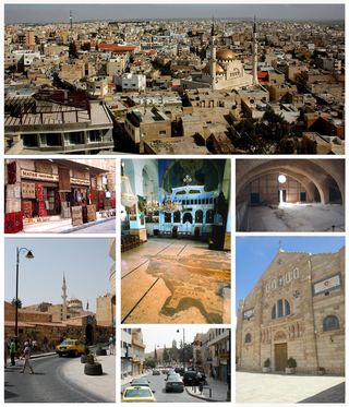
Madaba is the capital city of Madaba Governorate in central Jordan, with a population of about 60,000. It is best known for its Byzantine and Umayyad mosaics, especially a large Byzantine-era mosaic map of the Holy Land. Madaba is located 30 kilometres south-west of the capital Amman.

<span class="mw-page-title-main">Palestine Exploration Fund</span> British society founded in 1865

The Palestine Exploration Fund is a British society based in London. It was founded in 1865, shortly after the completion of the Ordnance Survey of Jerusalem by Royal Engineers of the War Department. The Fund is the oldest known organization in the world created specifically for the study of the Levant region, also known as Palestine. Often simply known as the PEF, its initial objective was to carry out surveys of the topography and ethnography of Ottoman Palestine – producing the PEF Survey of Palestine. Its remit was considered to fall between an expeditionary survey and military intelligence gathering. There was also strong religious interest from Christians; William Thomson, Archbishop of York, was the first President of the PEF.

<span class="mw-page-title-main">Edward Robinson (scholar)</span> American biblical scholar (1794-1863)

Edward Robinson was an American biblical scholar known for his magnum opus, Biblical Researches in Palestine, the first major work in Biblical Geography and Biblical Archaeology, which earned him the epithets "Father of Biblical Geography" and "Founder of Modern Palestinology."

<span class="mw-page-title-main">Madaba Map</span> 6th-century mosaic map of the Holy Land

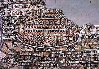
The Madaba Map, also known as the Madaba Mosaic Map, is part of a floor mosaic in the early Byzantine church of Saint George in Madaba, Jordan.

<span class="mw-page-title-main">Bayt Dajan</span> Place in Jaffa, Mandatory Palestine

Bayt Dajan, also known as Dajūn, was a Palestinian Arab village situated approximately 6 kilometers (3.7 mi) southeast of Jaffa. It is thought to have been the site of the biblical town of Beth Dagon, mentioned in the Book of Joshua and in ancient Assyrian and Ancient Egyptian texts. In the 10th century CE, it was inhabited mostly by Samaritans.

Anton Albert Heinrich Ludwig von Wildenbruch was a Prussian general and diplomat.

<span class="mw-page-title-main">Aboud</span> Palestinian village in Ramallah and al-Bireh, State of Palestine

Aboud is a Palestinian village in the Ramallah and al-Bireh Governorate of the State of Palestine, in the central West Bank, northwest of Ramallah and 30 kilometers north of Jerusalem. Nearby towns include al-Lubban to the northeast and Bani Zeid to the northwest.

<span class="mw-page-title-main">Bethany</span> Municipality type B in Jerusalem, Israel

Bethany, locally called in Arabic Al-Eizariya or al-Aizariya, is a Palestinian town in the Jerusalem Governorate of Palestine, bordering East Jerusalem, in the West Bank. The name al-Eizariya refers to the New Testament figure Lazarus of Bethany, who according to the Gospel of John, was raised from the dead by Jesus in the town. The traditional site of the miracle, the Tomb of Lazarus, in the city is a place of pilgrimage.

<span class="mw-page-title-main">Abraham Goos</span> Dutch cartographer, publisher, and engraver

Abraham Goos was a Dutch cartographer, publisher, and engraver. He made globes, maps of North America, a comprehensive map of European coastlines, and the first printed Hebrew language map of The Holy Land.

<span class="mw-page-title-main">Travelogues of Palestine</span> Descriptions of the region of Palestine by travellers

Travelogues of Palestine are the written descriptions of the region of Palestine by travellers, particularly prior to the 20th century. The works are important sources in the study of the history of Palestine and of Israel. Surveys of the geographical literature on Palestine were published by Edward Robinson in 1841, Titus Tobler in 1867 and subsequently by Reinhold Röhricht in 1890. Röhricht catalogued 177 works between 333 – 1300 CE, 19 works in the 14th century, 279 works in the 15th century, 333 works in the 16th century, 390 works in the 17th century, 318 works in the 18th century and 1,915 works in the 19th century.

<span class="mw-page-title-main">Ordnance Survey of Jerusalem</span> 1864–65 mapping of Jerusalem

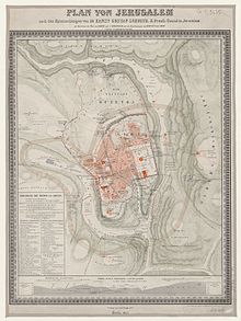
The Ordnance Survey of Jerusalem of 1864–65 was the first scientific mapping of Jerusalem, and the first Ordnance Survey to take place outside the United Kingdom. It was undertaken by Charles William Wilson, a 28-year-old officer in the Royal Engineers corps of the British Army, under the authority of Sir Henry James, as Superintendent of the Ordnance Survey, and with the sanction of George Robinson, 1st Marquess of Ripon as Secretary of State for War. The team of six Royal Engineers began their work on 3 October 1864. The work was completed on 16 June 1865, and the report was published on 29 March 1866.

<span class="mw-page-title-main">Arculf Map of Jerusalem</span>

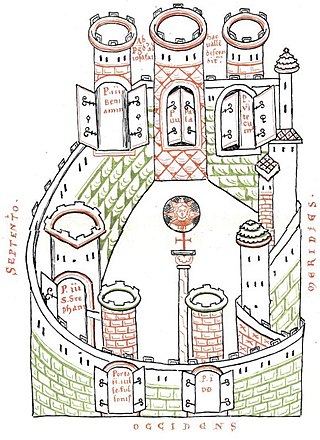
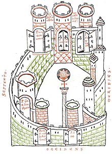
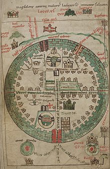
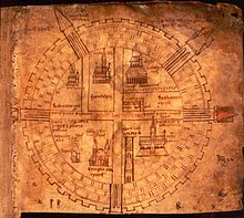
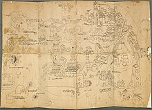
The Arculf Map of Jerusalem is an ancient ground plan map of the city of Jerusalem which was published in manuscripts of the first book of De Locis Sanctis by Arculf via Adomnán, dated to 680 CE. Not all the known manuscripts of the text include the maps and plans. The earliest known manuscript showing the map dates from the ninth century, two centuries after Arculf's journey.

The cartography of the region of Palestine, also known as cartography of the Holy Land and cartography of the Land of Israel, is the creation, editing, processing and printing of maps of the region of Palestine from ancient times until the rise of modern surveying techniques. For several centuries during the Middle Ages it was the most prominent subject in all of cartography, and it has been described as an "obsessive subject of map art".

<span class="mw-page-title-main">1858 Van de Velde maps of Palestine and Jerusalem</span>

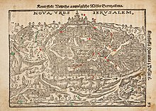
The Van de Velde maps of Palestine and Jerusalem were an important scientific mapping of the region of Palestine and mapping of Jerusalem, published in 1858 by Dutch cartographer Charles William Meredith van de Velde.

<span class="mw-page-title-main">PEF Survey of Palestine</span> 1872–1877 and 1880 map surveys

The PEF Survey of Palestine was a series of surveys carried out by the Palestine Exploration Fund (PEF) between 1872 and 1877 for the completed Survey of Western Palestine and in 1880 for the soon abandoned Survey of Eastern Palestine. The survey was carried out after the success of the Ordnance Survey of Jerusalem by the newly-founded PEF, with support from the War Office. Twenty-six sheets were produced for "Western Palestine" and one sheet for "Eastern Palestine". It was the first fully scientific mapping of Palestine.

<span class="mw-page-title-main">1840–41 Royal Engineers maps of Palestine, Lebanon and Syria</span>

The 1840–41 Royal Engineers maps of Palestine, Lebanon and Syria was an early scientific mapping of Palestine, Lebanon and Syria.

<span class="mw-page-title-main">Kiepert maps of Palestine and Jerusalem</span>

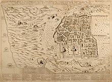
The Kiepert maps of Palestine and Jerusalem were important scientific mappings of the region of Palestine and mappings of Jerusalem, initially published in 1841 by German cartographer Heinrich Kiepert as the maps accompanying Biblical Researches in Palestine, the magnum opus of the "Father of Biblical Geography", Edward Robinson.

<span class="mw-page-title-main">Schick models of Jerusalem</span> Wooden models of notable buildings in Jerusalem

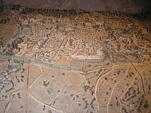
The Schick models of Jerusalem are notable wooden models of buildings and areas in the city of Jerusalem constructed by Conrad Schick in the late 19th century. The series of models covered the Church of the Holy Sepulchre, the Islamic buildings of Al-Aqsa on the Temple Mount and the terrain beneath it, as well as replicas of the Jewish Temple based on the information available in his time, and benefitting from his architectural knowledge.

<span class="mw-page-title-main">Yehoshua Ben-Arieh</span> Israeli geographer (1928–2023)

Yehoshua Ben-Arieh was an Israeli geographer. He served as rector of the Hebrew University of Jerusalem from 1993 to 1997. He won the Israel Prize in 1999. He died on 25 December 2023, at the age of 95.

References

  1. Rubin 2008, pp. 125, 130, 136: "It is important, too, to note that these maps of the Holy City were made by Christians for a European Christian audience, at a time when Jerusalem was in the hands of the Muslims [Footnote: Indeed, there is a rather different genre of images of Jerusalem that was common among the [Christian] Orthodox, and only a few Jewish and Muslim graphic images are known from that period]... most of the early printed maps were made by Christians for a Christian audience, and they strived to create and promote a Christian image of the Holy City, even though it was under Muslim rule... The maps aimed at creating the image of an eternal Christian city as an alternative to the reality of a poor Oriental town."
  2. Levy-Rubin & Rubin 1996, p. 352: "Although Jerusalem was indeed holy to Jews and Muslims as well as to Christians, there are almost no such depictions of the city that were drawn by either of the first two groups; it seems that generally this was a Christian genre."
  3. Rubin 2008, p. 124.
  4. 1 2 3 4 5 6 7 8 9 10 11 Rubin 2008, p. 123.
  5. 1 2 Levy-Rubin & Rubin 1996, p. 353.
  6. Rubin 2008, p. 123a: "...there are about five hundred known maps dating from the late fifteenth to the mid-nineteenth century... a few were based on actual travel to the east, but most were merely copies and imitations of travelers’ maps, or imaginary and fantastic images that were largely unrelated to geographical reality."
  7. 1 2 3 4 5 Ben-Arieh 1974, pp. 150–160.
  8. 1 2 Wilson 1865, pp. 1–18.
  9. Siew 2008, p. 10.
  10. 1 2 Levy-Rubin & Rubin 1996, pp. 352–353.
  11. Piccirillo, Michele (21 September 1995). "A Centenary to be celebrated". Jordan Times. Franciscan Archaeology Institute. Retrieved 18 January 2019. It was only Abuna Kleofas Kikilides who realised the true significance, for the history of the region, that the map had while visiting Madaba in December 1896. A Franciscan friar of ltalian-Croatian origin born in Constantinople, Fr. Girolamo Golubovich, helped Abuna Kleofas to print a booklet in Greek about the map at the Franciscan printing press of Jerusalem. Immediately afterwards, the Revue Biblique published a long and detailed historic-geographic study of the map by the Dominican fathers M.J. Lagrange and H. Vincent after visiting the site themselves. At the same time. Father J. Germer-Durand of the Assumptionist Fathers published a photographic album with his own pictures of the map. In Paris, C. Clermont-Gannau, a well known oriental scholar, announced the discovery at the Academie des Sciences et belles Lettres.
  12. Tsafrir 1999, pp. 155–163.
  13. Flower, Kevin (11 February 2010). "Archaeologists find Byzantine era road". CNN. Archived from the original on 7 April 2022. Retrieved 28 December 2019.
  14. 1 2 Siew 2008, pp. 18, 19, 24.
  15. 1 2 3 Harvey 1987, p. 466.
  16. 1 2 Tobler 1858, p. 3.
  17. Paul Stephenson (2022). New Rome: The Empire in the East. Harvard University Press. ISBN   9780674659629. Archived from the original on 26 October 2023. Retrieved 26 October 2023.
  18. 1 2 3 4 Levy-Rubin 1995, pp. 162–167.
  19. 1 2 3 4 Röhricht 1892, pp. 34–35.
  20. Siew 2008, p. 13.
  21. 1 2 3 Siew 2008, p. 11.
  22. Levy-Rubin & Rubin 1996, p. 360.
  23. 1 2 3 4 Harvey 1987, p. 473.
  24. 1 2 3 4 Levy-Rubin & Rubin 1996, p. 354.
  25. 1 2 Siew 2008, p. 3.
  26. 1 2 3 4 Siew 2008, p. 12.
  27. Berger 2012, p. 15.
  28. Levy-Rubin & Rubin 1996, p. 358.
  29. 1 2 Röhricht 1892, p. 39.
  30. 1 2 3 4 Levy-Rubin 1995, p. 165.
  31. Levy-Rubin 1995, p. 163.
  32. 1 2 Levy-Rubin & Rubin 1996, p. 356.
  33. 1 2 Siew 2008, p. 19.
  34. 1 2 Röhricht 1892, p. 36.
  35. 1 2 Röhricht 1892, p. 38.
  36. 1 2 3 Edson 2012, pp. 200–201.
  37. Harvey 1987, p. 474.
  38. 1 2 Siew 2008, p. 35.
  39. Siew 2008, pp. 36–38.
  40. 1 2 3 Siew 2008, p. 15.
  41. Tobler 1858, p. 8.
  42. Siew 2008, p. 16.
  43. Harvey 1987, p. 475.
  44. 1 2 3 Moldovan 1983, p. 17.
  45. Shalev 2011, p. 127.
  46. 1 2 Součková 1980, p. 21.
  47. 1 2 Amico 1620, p. 8.
  48. 1 2 Tishby 2001, p. 37.
  49. Rubin 2013, pp. 106–132.
  50. Rubin 2013, p. 111.
  51. Rubin 2013, p. 110.
  52. Rubin 2013, pp. 108, 110.
  53. Rubin 2013, pp. 112, 113.
  54. 1 2 3 Rubin 2008, pp. 130–132.
  55. Rubin 2006, pp. 267–290.
  56. 1 2 Ben-Arieh 1974, p. 152.
  57. Yehoshua Ben-Arieh, ‘The first surveyed maps of Jerusalem’, Eretz-Israel. Archaeological, Historical and Geographical Studies 11 (1973) [Hebrew].
  58. Ben-Arieh 1974, p. 154.
  59. Ben-Arieh 1974, p. 156.
  60. Ben-Arieh 1974, p. 158.
  61. 1 2 Tobler 1858, p. 155.
  62. Addition to ‘Notes on Acre’” Archived 2023-05-05 at the Wayback Machine , Papers on Subjects connected with the Duties of the Corps of Royal Engineers, VII, 1845, pp. 46–47
  63. 1 2 Williams 1849, pp. 1–130.
  64. Jones 1973, p. 32.
  65. 1 2 3 Goren 2017, p. 48.
  66. 1 2 Moscrop 2000, p. 22.
  67. Goren, Faehndrich & Schelhaas 2017, p. 69.
  68. 1 2 Foliard 2017, p. 42.
  69. Levy-Rubin & Rubin 1996, p. 378.
  70. 1 2 Moscrop 2000, p. 57.
  71. 1 2 3 Rubin 2007, pp. 71–79.
  72. Smith O'Neil, Dr Maryvelma (20 August 2012). "Liberate the Illés Relief". Al Jazeera. Archived from the original on 26 March 2020. Retrieved 26 September 2019.

Bibliography

Further reading