


Whereas most known early maps of Africa were prepared in the framework of the colonial enterprise, some indigenous maps have been recently uncovered, particularly in West Africa and Ethiopia. [1] [2]
The earliest cartographic depictions of Africa are found in early world maps. In classical antiquity, Africa (also Libya ) was assumed to cover the quarter of the globe south of the Mediterranean, an arrangement that was adhered to in medieval T and O maps.
The only part of Africa well known in antiquity was the coast of North Africa, described in Greek periplus from the 6th century BC. Hellenistic era geographers defined Ancient Egypt as part of Asia, taking the boundary of Asia and Egypt to lie at the Catabathmus Magnus (the escarpment of Akabah el-Kebir in western Egypt). Ptolemy's world map (2nd century) shows a reasonable awareness of the general topography of North Africa, but is unaware of anything south of the equator. The limit of Ptolemy's knowledge in the west is Cape Spartel (35° 48′ N); while he does assume that the coast eventually retreats in a "Great Gulf of the Western Ocean", this is not likely based on any knowledge of the Gulf of Guinea. [3] In the east, Ptolemy is aware of the Red Sea (Sinus Arabicus) and the protrusion of the Horn of Africa, describing the gulf south of the Horn of Africa as Sinus Barbaricus.
With the European exploration of Africa from the 15th century, maps of Africa became more precise. The Fra Mauro map of 1459 shows a more detailed picture of Africa as a continent, including the Cape of Diab at its southernmost point, reflecting an expedition of 1420. Sebastian Münster's Cosmographia (1545) labels the Cape of Good Hope, reached by Bartolomeu Dias in 1488, as caput bonae spei. The interior of Africa was not mapped in any detail before the second half of the 19th century.
Aromata, also called the Spice Port, was an emporium and seaport in the Horn of Africa, today a part of Somalia. It lay near the tip of Cape Guardafui, which was itself called the "promontory of spices". It was notable for its produce of resins and various herbs.

The Ptolemy world map is a map of the world known to Greco-Roman societies in the 2nd century. It is based on the description contained in Ptolemy's book Geography, written c. 150. Based on an inscription in several of the earliest surviving manuscripts, it is traditionally credited to Agathodaemon of Alexandria.
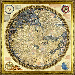
The Fra Mauro map is a map of the world made around 1450 by the Italian (Venetian) cartographer Fra Mauro, which is “considered the greatest memorial of medieval cartography." It is a circular planisphere drawn on parchment and set in a wooden frame that measures over two by two meters. Including Asia, the Indian Ocean, Africa, Europe, and the Atlantic, it is orientated with south at the top. The map is usually on display in the Biblioteca Nazionale Marciana in Venice in Italy.

The geography of North Africa has been reasonably well known among Europeans since classical antiquity in Greco-Roman geography. Northwest Africa was known as either Libya or Africa, while Egypt was considered part of Asia.
The earliest known world maps date to classical antiquity, the oldest examples of the 6th to 5th centuries BCE still based on the flat Earth paradigm. World maps assuming a spherical Earth first appear in the Hellenistic period. The developments of Greek geography during this time, notably by Eratosthenes and Posidonius culminated in the Roman era, with Ptolemy's world map, which would remain authoritative throughout the Middle Ages. Since Ptolemy, knowledge of the approximate size of the Earth allowed cartographers to estimate the extent of their geographical knowledge, and to indicate parts of the planet known to exist but not yet explored as terra incognita.
Agame was a former province in northern Ethiopia. It includes the northeastern corner of the Ethiopian Empire, borders in Eritrea, Tembien, Kalatta Awlalo and Enderta in the south, and both the Eritrean and Ethiopian Afar lowlands in the east. This relative location of Agame is at the strategic crossroads between the Red Sea and the northern Tigrayan plateau on the other. In pre-1991, Agame had a total area of about 4,889 square kilometres (1,888 sq mi) with an estimated population of 344,800.

The Geography, also known by its Latin names as the Geographia and the Cosmographia, is a gazetteer, an atlas, and a treatise on cartography, compiling the geographical knowledge of the 2nd-century Roman Empire. Originally written by Claudius Ptolemy in Greek at Alexandria around AD 150, the work was a revision of a now-lost atlas by Marinus of Tyre using additional Roman and Persian gazetteers and new principles. Its translation into Arabic in the 9th century was highly influential on the geographical knowledge and cartographic traditions of the Islamic world. Alongside the works of Islamic scholars - and the commentary containing revised and more accurate data by Alfraganus - Ptolemy's work was subsequently highly influential on Medieval and Renaissance Europe.

Tanqua Abergele is one of the Districts of Ethiopia, or woredas, in the Tigray Region of Ethiopia. Part of the Mehakelegnaw Zone, Abergele is bordered on the south by the Wag Hemra Zone of Amhara Region, then by the Tekezé River on the west which separates it from North Gondar Zone of Amhara Region, on the north by Kola Tembien, on the east by Degua Tembien and on the southeast by the Debub Misraqawi Zone. The administrative center of this woreda is Yechila; other towns in Abergele include Sele and Jijike. Abergele is one of the low lying districts of central Tigray and the Tanqua River, which originates near Hagere Selam, flows through this woreda and joins the Geba just north of Jijike. It further feeds the Tekezé River. The Tekezé Dam is also located in this woreda.

Hawzen is an Ethiopian District or woreda in the Tigray Region of Ethiopia. Part of the Misraqawi Zone, Hawzen is bordered on the south by Kilte Awulaelo, on the west by the Mehakelegnaw (Central) Zone, on the north by Ganta Afeshum, and on the east by Saesi Tsaedaemba. Towns in Hawzen include Hawzen and Megab; villages include Koraro.
Saharti Samre is one of the Districts of Ethiopia, or woredas, in the Tigray Region of Ethiopia. Part of the Debub Misraqawi (Southeastern) Zone, Samre is bordered on the south by the Amhara Region, on the west and north by the Mehakelegnaw (Central) Zone, on the northeast by Enderta, on the east by Hintalo Wajirat, and on the southeast by Debubawi (Southern) Zone. Towns in this woreda include Gijet and Samre.
The provinces of Eritrea existed since pre-Axumite times and became administrative provinces from Eritrea's incorporation as a colony of Italy until the conversion of the provinces into administrative regions. Many of the provinces had their own local laws since the 13th century.
Medieval Islamic geography and cartography refer to the study of geography and cartography in the Muslim world during the Islamic Golden Age. Muslim scholars made advances to the map-making traditions of earlier cultures, particularly the Hellenistic geographers Ptolemy and Marinus of Tyre, combined with what explorers and merchants learned in their travels across the Old World (Afro-Eurasia). Islamic geography had three major fields: exploration and navigation, physical geography, and cartography and mathematical geography. Islamic geography reached its apex with Muhammad al-Idrisi in the 12th century.
The cartography of India begins with early charts for navigation and constructional plans for buildings. Indian traditions influenced Tibetan and Islamic traditions, and in turn, were influenced by the British cartographers who solidified modern concepts into India's map making.

The cartography of Asia can refer to the representation of Asia on a map, or to depictions of the world by cartographers from Asia. Depictions of portions of Asia have existed on maps as early as the 6th century BCE, with maps being drafted to depict the Babylonian, Hellenistic Greek, and Han dynasty empires.
The earliest cartographic depictions of Europe are found in early world maps. In classical antiquity, Europe was assumed to cover the quarter of the globe north of the Mediterranean, an arrangement that was adhered to in medieval T and O maps.

The Magnus Sinus or Sinus Magnus, also anglicized as the Great Gulf, was the form of the Gulf of Thailand and South China Sea known to Greek, Roman, Arab, Persian, and Renaissance cartographers before the Age of Discovery. It was then briefly conflated with the Pacific Ocean before disappearing from maps.
The Dragon's Tail is a modern name for the phantom peninsula in southeast Asia which appeared in medieval Arabian and Renaissance European world maps. It formed the eastern shore of the Great Gulf east of the Golden Chersonese, replacing the "unknown lands" which Ptolemy and others had thought surrounded the "Indian Sea".
Bur was a large historical province, across the present-day Ethio-Eritrean border. As happened with other regions, it was divided into Upper Bur and Lower Bur. Its territory covered parts of Agame, the entire Akele Guzay and lands further to the east, including perhaps even the Buri peninsula.
Tembien is a historic region in Tigray Region and former provinces of Ethiopia. It is a mountainous area of that country. During the reforms in 1994–95, the old provinces were replaced with regions, zones and woredas. The area of the former province is now split over the woredas of Dogua Tembien and Kola Tembien.
Ts’emi’e is a historical region towards the foot of the Rift Valley escarpment in Ethiopia and Eritrea.