Continental Europe or mainland Europe is the contiguous mainland of Europe, excluding its surrounding islands. It can also be referred to ambiguously as the European continent, – which can conversely mean the whole of Europe – and, by some, simply as the Continent. When Eurasia is regarded as a single continent, Europe is treated both as a continent and subcontinent.

The Americas, sometimes collectively called America, are a landmass comprising the totality of North and South America. The Americas make up most of the land in Earth's Western Hemisphere and comprise the New World.

The Western Hemisphere is the half of the planet Earth that lies west of the Prime Meridian and east of the 180th meridian. The other half is called the Eastern Hemisphere. Geo-politically, the term Western Hemisphere is often used as a metonym for the Americas or the "New World", even though geographically the hemisphere also includes parts of other continents.
Geopolitics is the study of the effects of Earth's geography on politics and international relations. While geopolitics usually refers to countries and relations between them, it may also focus on two other kinds of states: de facto independent states with limited international recognition and relations between sub-national geopolitical entities, such as the federated states that make up a federation, confederation, or a quasi-federal system.

The Southern Levant is a geographical region encompassing the southern half of the Levant. It corresponds approximately to modern-day Israel, Palestine, and Jordan; some definitions also include southern Lebanon, southern Syria and/or the Sinai Peninsula. As a strictly geographical description, it is sometimes used by archaeologists and historians to avoid the religious and political connotations of other names for the area.

A landmass, or land mass, is a large region or area of land that is in one piece and not broken up by oceans. The term is often used to refer to lands surrounded by an ocean or sea, such as a continent or a large island. In the field of geology, a landmass is a defined section of continental crust extending above sea level.

The Eastern Hemisphere is the half of the planet Earth which is east of the prime meridian and west of the antimeridian. It is also used to refer to Afro-Eurasia and Australia, in contrast with the Western Hemisphere, which includes mainly North and South America. The Eastern Hemisphere may also called the "Oriental Hemisphere", and may in addition be used in a cultural or geopolitical sense as a synonym for "Old World."

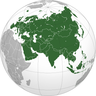
Geography of Asia reviews geographical concepts of classifying Asia, the central and eastern part of Eurasia, comprising 58 countries and territories.
Geostrategy, a subfield of geopolitics, is a type of foreign policy guided principally by geographical factors as they inform, constrain, or affect political and military planning. As with all strategies, geostrategy is concerned with matching means to ends Strategy is as intertwined with geography as geography is with nationhood, or as Colin S. Gray and Geoffrey Sloan state it, "[geography is] the mother of strategy."

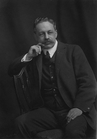
Nicholas John Spykman was an American political scientist who was Professor of International Relations at Yale University from 1928 until his death in 1943. He was one of the founders of the classical realist school in American foreign policy, transmitting Eastern European political thought to the United States.

The term "New World" is used to describe the majority of lands of Earth's Western Hemisphere, particularly the Americas. The term gained prominence in the early 16th century during Europe's Age of Discovery, after Italian explorer Amerigo Vespucci published the Latin-language pamphlet Mundus Novus, presenting his conclusion that these lands, soon called America based on Amerigo's name, constitute a new continent.
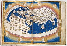
"The Geographical Pivot of History" is an article submitted by Halford John Mackinder in 1904 to the Royal Geographical Society that advances his heartland theory. In this article, Mackinder extended the scope of geopolitical analysis to encompass the entire globe. He defined Afro-Eurasia as the "world island" and its "heartland" as the area east of the Volga, south of the Arctic, west of the Yangtze, and north of the Himalayas. Due to its strategic location and natural resources, Mackinder argued that whoever controlled the "heartland" could control the world.

The Americas, also known as America, are lands of the Western Hemisphere, composed of numerous entities and regions variably defined by geography, politics, and culture.
In world history, post-classical history refers to the period from about 500 CE to 1500 CE, roughly corresponding to the European Middle Ages. The period is characterized by the expansion of civilizations geographically and the development of trade networks between civilizations. This period is also called the medieval era, post-antiquity era, post-ancient era, pre-modernity era, or pre-modern era.

Determining the boundaries between the continents is generally a matter of geographical convention. Several slightly different conventions are in use. The number of continents is most commonly considered seven but may range as low as four when Afro-Eurasia and the Americas are both considered as single continents. An island can be considered to be associated with a given continent by either lying on the continent's adjacent continental shelf or being a part of a microcontinent on the same principal tectonic plate. An island can also be entirely oceanic while still being associated with a continent by geology or by common geopolitical convention. Another example is the grouping into Oceania of the Pacific Islands with Australia and Zealandia.

Prehistory, also called pre-literary history, is the period of human history between the first known use of stone tools by hominins c. 3.3 million years ago and the beginning of recorded history with the invention of writing systems. The use of symbols, marks, and images appears very early among humans, but the earliest known writing systems appeared c. 5,200 years ago. It took thousands of years for writing systems to be widely adopted, with writing spreading to almost all cultures by the 19th century. The end of prehistory therefore came at different times in different places, and the term is less often used in discussing societies where prehistory ended relatively recently.

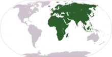
Afro-Eurasia is a landmass comprising the continents of Africa, Asia, and Europe. The terms are compound words of the names of its constituent parts. Afro-Eurasia has also been called the "Old World", in contrast to the "New World" referring to the Americas.

A continent is any of several large geographical regions. Continents are generally identified by convention rather than any strict criteria. A continent could be a single landmass or a part of a very large landmass, as in the case of Asia or Europe. Due to this, the number of continents varies; up to seven or as few as four geographical regions are commonly regarded as continents. Most English-speaking countries recognize seven regions as continents. In order from largest to smallest in area, these seven regions are Asia, Africa, North America, South America, Antarctica, Europe, and Australia. Different variations with fewer continents merge some of these regions; examples of this are merging North America and South America into America, Asia and Europe into Eurasia, and Africa, Asia, and Europe into Afro-Eurasia.
Eurasia is the largest continental area on Earth, comprising all of Europe and Asia. According to some geographers, physiographically, Eurasia is a single continent. The concepts of Europe and Asia as distinct continents date back to antiquity, but their borders have historically been subject to change, for example to the ancient Greeks Asia originally included Africa but they classified Europe as separate land. Eurasia is connected to Africa at the Suez Canal, and the two are sometimes combined to describe the largest contiguous landmass on Earth, Afro-Eurasia.