Castle Hill, Townsville

Last updated

Castle Hill as seen from the Strand, Townsville Castle Hill, Townsville.jpg
Castle Hill as seen from the Strand, Townsville
Monolithic Castle Hill dominates the Townsville coastline Aerial view of Townsville.jpg
Monolithic Castle Hill dominates the Townsville coastline

Castle Hill is a heritage-listed isolated pink granite monolith in the suburb of Castle Hill, City of Townsville, Queensland, Australia. [1] [2] Its Indigenous name is Cootharinga, sometimes written as Cooderinga. [3] [4]

Contents

It rises to a height of some 286 metres (938 ft) above sea level and dominates the city skyline. [5] It is one of the most distinctive natural features on the Queensland coast. There are a number of vantage points from which to view the city below and also across Cleveland Bay to nearby Magnetic Island. Castle Hill (as a hill) was listed on the Queensland Heritage Register in 1993. [5]

Geography and features

Castle Hill, Townsville (January 2008) Castle Hill Townsville.jpg
Castle Hill, Townsville (January 2008)
Robert Towns monument, relocated to Castle Hill, Townsville Robert Towns monument.jpg
Robert Towns monument, relocated to Castle Hill, Townsville

The hill is an inselberg of Carboniferous Permian origins, rising abruptly from the younger Quaternary coastal plain. [6] The surface is primarily bare rock or shallow lithosols with small areas of duplex soils. There are three peaks to the summit. There is a former quarry site on the southern slopes, accessed via Stagpole Street, and on the northern cliff face a large graffiti on 'The Saint' is painted. [7]

The bitumen "Castle Hill Road" winds for 2.6 kilometres (1.6 mi) from the northeast slopes to the summit of the second peak, on which the Hynes Lookout platform has been erected. [8]

There are several buildings and installations on the hill. On the southern face was a two-storeyed octagonal building of concrete block work, which formerly housed the Panorama Restaurant, which has now been demolished. A carpark associated with the former restaurant is located nearby to the north. Other structures on the site include several water reservoirs and three radio communication installations. On the northernmost peak of the summit is a 1942 observation post, a low, square, concrete bunker with observation apertures.

Robert Towns monument

Plaque explaining the origins of the Robert Towns monument Robert Towns monument detail.jpg
Plaque explaining the origins of the Robert Towns monument

In 1873, Robert Towns, the founder of Townsville, died in Sydney and was buried in Balmain Cemetery.

In 1940, the Municipality of Leichhardt decided to replace that cemetery with parkland (called Pioneers Memorial Park). [9] The plans were advertised and families were invited to arrange for re-interment of bodies or removal of memorials. [10] In 1941, the Leichhardt Council offered the memorial from the grave of Robert Towns to the Townsville City Council. [11] [12] In January 1942, Townsville City Council voted to accept the memorial and transport it to Townsville at a cost of £ 23/10/-. The decision to accept the monument was opposed by two councillors, one claiming that Robert Towns had done nothing for Townsville and it was only sheer good luck that caused the city to bear his name. [13] A local resident, Tom Gleeson, proposed "high on the peak of Castle Hill, overlooking the harbour" would be a suitable location for the monument. [14] Having arrived in Townsville, the monument was then placed in storage for a number of years.

It was not until October 1947 that the Council discussed where to place the monument. A number of locations were considered: Castle Hill, the Botanic Gardens, in front of the Queens Hotel, the Anzac Memorial Park and the Railway Oval, but Castle Hill was ultimately the council's choice. [15] [16] In February 1948, the Queensland Government gave its approval to the council to place the monument in the centre of the car parking area on the top of Castle Hill. [17]

Over two years later, in November 1949, the monument was finally placed on Castle Hill, where it stands to the present day. [18] A plaque was added to explain the origins of the monument. [19]

Flora

The vegetation, largely regenerative, is dominated by indigenous plant species. Approximately 300 plant species have been identified. [6] Of particular importance are:

The plant communities are predominantly mixed Eucalyptus spp. (E. drepaniphylla, E. dolichocarpa, E. tessellaris, E. Platyphylla, E. papuana) with variable woody understorey. Small areas of semi-evergreen notophyll vine thickets, not native to the site, occur in mesic areas such as gullies. On the gentler slopes kangaroo grass (Themeda triandra) is the dominant herbaceous species, while giant spear grass (Heteropogon triticeus) dominates on the steeper slopes. Specialised flora also occur on the cliffs and rocky outcrops, in particular the Triodia hummock grass community, Ficus spp. (five species) and orchids (two species). Introduced flora comprised almost 50 species, including Ficus benghalensis (Banyan).

Fauna

The fauna, which has not been surveyed comprehensively, includes the unadorned rock-wallaby. [6] The avifauna had been surveyed, with over 50 bird species either visiting or residing on the hill. Peregrine falcons and brahminy kites nest here. Echidna, death adder and quail have been seen.

Activities

View from Castle Hill towards the Townsville Port Townsville from castle hill lookout near sunset.jpg
View from Castle Hill towards the Townsville Port

Many locals walk up Castle Hill for regular exercise. There are many different routes to the top, by road or by goat track. The Goat Track is a rough path that consists of 758 individual stairs from start to finish. Castle Hill is also a popular tourist site. Education groups regularly using the reserve to study natural environments, community history and urban geography. The North Queensland Conservation Council is undertaking a voluntary bush rejuvenation program of the site. [6]

History

Early records and creation of a Reserve

Castle Hill has formerly also been known locally as Cutheringa, Cudtheringa, Cootharinga, and Mt Cutheringa. [5] The Aboriginal history associated with Cutheringa has not been recorded, but its name survives as one of only two known Australian Indigenous place names in the Townsville region, the other being Pallarenda.

Castle Hill was one of the earliest sites named by Andrew Ball who, together with MW Reid, were the first Europeans to explore the Ross River area in April 1864. [6] The settlement established here was known initially as Castletown, until the name was replaced by Townsville in 1865. The hill became a much admired local landmark, evoking aesthetic delight and a unique sense of identity. This prominent link between urban life and nature largely determined the disordered layout of Townsville's streets and in the late 19th century was frequented for recreational pursuits such as botanising and nature study. Townsville residents also illegally plundered timber and firewood from Castle Hill. Wild goats further ravaged the native vegetation. By the late 1880s the Townsville Herald (1822–97) voiced considerable public outrage at the continued denudation of Castle Hill. These concerns were part of Queensland-wide debates on forest resource use and conservation. In an innovative approach to conservation, the Townsville Municipal Council applied to the Crown to establish the Hill as a reserve under their protective trusteeship, and on 30 June, Castle Hill was gazetted a Recreation Reserve of 228 hectares (560 acres). However, despite the appointment of Crown Land Rangers and later, a Conservator of Trees for Castle Hill, the council was able to do little to restore the tree cover of the reserve during the depression years of the 1890s. Alderman Edward Downs and EJ Banfield privately planted various trees through the 1890s, including the surviving banyans, but by the 20th century, popular interest in preserving the natural vegetation of Castle Hill had waned. Small areas of the reserve were excised in the 1890s for water reserves and quarrying, but by 1900 it remained an unimproved reserve of close to 215 hectares (530 acres).

Only into the 1930s did the Council appear to directly address the Castle Hill environment. The goats were removed, permitting natural revegetation and in 1935-36 a road to the summit was constructed as an employment generating scheme, partly funded by the Main Roads Commission. Hynes Road (now Castle Hill Road) and Lookout were named after the then Minister for Labour and Industry, Hon. MP Maurice Hynes.

World War II

Ammunition magazine, situated below road up Castle Hill Bunkerscastlehill.jpg
Ammunition magazine, situated below road up Castle Hill
1952 photograph of the quarry near Sturt Street Castle Hill (Queensland) aerial.jpg
1952 photograph of the quarry near Sturt Street

During the Second World War Castle Hill was used as a communications and observation post. Infantry and field regiments of the 5th Australian Division were deployed on the hill, and the observation post they constructed remains. In 1942 a radar station was established on the summit, and searchlights extended halfway up the hill. The road up Castle Hill was closed to traffic on 12 March 1942 to enable the construction of the above-ground Green Street Bunker near Sidney Street, West End. Unconfirmed reports indicate approval was given for the construction of an underground Area Combined Headquarters in Castle Hill in 1943. [20]

Development

Since the 1950s areas from within the recreation reserve, including the summit, were excised for a variety of purposes: further water reserves and quarrying, a restaurant, car parking, communications installations and residential subdivision. By 1972 the Recreation Reserve had been reduced to about 143 hectares (350 acres). In 1983 a further 33 hectares (82 acres) were granted to Yarrawonga Pty Ltd under special lease as a potential development site. [6] The Yarrawonga subdivision is situated in the foothills of Castle Hillviews of North Ward and Magnetic Island; it has been described as the most expensive real estate outside south-east Queensland and is noted for its elevation and large homes, precariously placed on the foothills.[ citation needed ] Since 1974 radio communications installations erected at the summit have serviced the Civil Aviation Safety Authority, ambulance, fire brigade, police, state emergency services and customs.

Heritage listing

See also

Related Research Articles

<span class="mw-page-title-main">Townsville</span> City in Queensland, Australia

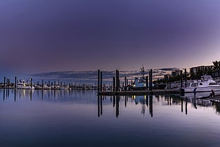
Townsville is a city on the north-eastern coast of Queensland, Australia. With a population of 180,820 as of June 2018, it is the largest settlement in North Queensland; it is unofficially considered its capital. Townsville hosts a significant number of governmental, community and major business administrative offices for the northern half of the state.

<span class="mw-page-title-main">Burdekin River</span> River in Queensland, Australia

The Burdekin River is a river located in North and Far North Queensland, Australia. The river rises on the northern slopes of Boulder Mountain at Valley of Lagoons, part of the western slope of the Seaview Range, and flows into the Coral Sea at Upstart Bay over 200 kilometres (124 mi) to the southeast of the source, with a catchment area of approximately 130,000 square kilometres (50,000 sq mi). The Burdekin River is Australia's largest river by (peak) discharge volume.

<span class="mw-page-title-main">Mackay, Queensland</span> City in Queensland, Australia

Mackay is a city in the Mackay Region on the eastern or Coral Sea coast of Queensland, Australia. It is located about 970 kilometres (603 mi) north of Brisbane, on the Pioneer River. Mackay is described as being in either Central Queensland or North Queensland, as these regions are not precisely defined. More generally, the area is known as the Mackay–Whitsunday Region. Nicknames of Mackay include the Sugar capital and Macktown.

<span class="mw-page-title-main">Ayr, Queensland</span> Town in Queensland, Australia

Ayr is a rural town and locality in the Shire of Burdekin, Queensland, Australia. It is the centre of a sugarcane-growing region and the administrative centre for the Burdekin Shire Council. In the 2016 census, the locality of Ayr had a population of 8,738 people.

<span class="mw-page-title-main">Mount Coot-tha, Queensland</span> Suburb of Brisbane, Queensland, Australia

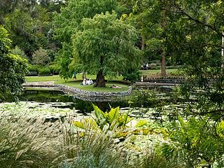
Mount Coot-tha is a mountain and a suburb of the City of Brisbane, Queensland, Australia. In the 2016 census, there were no residents in the suburb. Visible from much of the city, Mount Coot-tha is a popular bushland tourist destination including the Mount Coot-tha Lookout, Brisbane Botanic Gardens and Sir Thomas Brisbane Planetarium, as well as a mountain drive, bike trails, parks including a waterfall, and television and radio towers.

<i>Townsville Bulletin</i> Newspaper in Queensland, Australia

The Townsville Bulletin is a daily newspaper published in Townsville, Queensland, Australia, formerly known as the Townsville Daily Bulletin. It is the only daily paper that serves the northern Queensland region. The paper has a print edition, a subscription World Wide Web edition, and a subscription digital edition.

<span class="mw-page-title-main">Home Hill, Queensland</span> Town in Queensland, Australia

Home Hill is a rural town and locality in the Shire of Burdekin, Queensland, Australia. In the 2016 census, the locality of Home Hill had a population of 2,954 people.

<span class="mw-page-title-main">Shire of Murweh</span> Local government area in Queensland, Australia

The Shire of Murweh is a local government area in the Maranoa district, which is part of South West Queensland, Australia. The administrative centre and largest town in the shire is Charleville. In June 2018, the Shire of Murweh had a population of 4,318.

<span class="mw-page-title-main">Shire of Dalrymple</span> Local government area in Queensland, Australia

The Shire of Dalrymple was a local government area located in North Queensland, Australia, and surrounded but did not include the town of Charters Towers, at which its council and administrative centre was based. It covered an area of 68,324.5 square kilometres (26,380.2 sq mi), and existed as a local government entity from 1879 until 2008, when it amalgamated with the separate City of Charters Towers to form the Charters Towers Region.

<span class="mw-page-title-main">Shire of Eacham</span> Local government area in Queensland, Australia

The Shire of Eacham was a local government area of Queensland. It was located on the Atherton Tableland, a plateau forming part of the Great Dividing Range west of the city of Cairns. The shire, administered from the town of Malanda, covered an area of 1,126.4 square kilometres (434.9 sq mi), and existed as a local government entity from 1910 until 2008, when it amalgamated with several other councils in the Tableland area to become the Tablelands Region.

<span class="mw-page-title-main">Shire of Johnstone</span> Local government area in Queensland, Australia

The Shire of Johnstone was a local government area of Queensland. It was located on the Coral Sea coast about 90 kilometres (56 mi) south of the city of Cairns. The shire, administered from the town of Innisfail, covered an area of 1,639.1 square kilometres (632.9 sq mi), and existed as a local government entity from 1881 until 2008, when it amalgamated with the Shire of Cardwell to form the Cassowary Coast Region.

<span class="mw-page-title-main">Shire of Cardwell</span> Local government area in Queensland, Australia

The Shire of Cardwell was a local government area of Queensland. It was located on the Coral Sea coast about halfway between the cities of Cairns and Townsville. The shire, administered from the town of Tully, covered an area of 3,062.2 square kilometres (1,182.3 sq mi), and existed as a local government entity from 1884 until 2008, when it amalgamated with the Shire of Johnstone to form the Cassowary Coast Region.

<span class="mw-page-title-main">City of Charters Towers</span> Local government area in Queensland, Australia

The City of Charters Towers was a local government area in North Queensland, Australia, consisting of the centre and suburbs of the town of Charters Towers. Established in 1877, it was entirely surrounded by the Shire of Dalrymple, with which it amalgamated in 2008 to form the Charters Towers Region.

<span class="mw-page-title-main">Townsville City, Queensland</span> Suburb of Townsville, Queensland, Australia

Townsville City is a coastal suburb at the centre of the City of Townsville, Queensland, Australia. In the 2016 census, the suburb of Townsville City had a population of 2,910 people.

Cardstone is a rural locality in the Cassowary Coast Region, Queensland, Australia. In the 2016 census, Cardstone had a population of 17 people.

<span class="mw-page-title-main">Queensland Country Women's Association</span> Womens organisation in Queensland, Australia

The Queensland Country Women's Association (QCWA) is the Queensland chapter of the Country Women's Association in Australia. The association seeks to serve the interests of women and children in rural areas in Australia through a network of local branches. Established in 1922, local branches provide friendship and mutual support to their members while contributing to the betterment of life in their local communities. Over time, many branches have evolved to include support for wider issues such as domestic violence campaigns and fund-raising for international initiatives such as orphanages.

<span class="mw-page-title-main">Cyclone Leonta</span>

Cyclone Leonta was a tropical cyclone that caused severe damage in North Queensland on 9 March 1903. It lasted for around twelve hours, and was the most damaging cyclone ever to hit Townsville at that time, surpassing Cyclone Sigma of 1896, with approximately 14 lives lost. It caused approximately £250,000 damage in 1903 terms.

<span class="mw-page-title-main">John Melton Black</span>

John Melton Black (1830–1919) was a pioneer of Townsville, Queensland, Australia. Black ordered the expedition of Cleveland Bay to find a suitable site for a port and then established the Port of Townsville and the associated town of Townsville. He served for two terms as Mayor of Townsville.

Currajong is a heritage-listed detached house at 5 Castling Street, West End, City of Townsville, Queensland, Australia. It was built from 1887 to 1888. It was added to the Queensland Heritage Register on 21 October 1992.

<span class="mw-page-title-main">Feluga, Queensland</span> Suburb of Cassowary Coast Region, Queensland, Australia

Feluga is a rural locality in the Cassowary Coast Region, Queensland, Australia. In the 2016 census Feluga had a population of 251 people.

References

  1. "Castle Hill [hill] (entry 6446)". Queensland Place Names. Queensland Government . Retrieved 10 January 2014.
  2. "Castle Hill [suburb] (entry 44582)". Queensland Place Names. Queensland Government . Retrieved 10 January 2014.
  3. "CLEVELAND BAY AND THE TOWNSHIP OF TOWNSVILLE". The Brisbane Courier . Vol. XX, no. 2, 386. Queensland, Australia. 21 September 1865. p. 2. Archived from the original on 1 October 2020. Retrieved 27 September 2017 via National Library of Australia.
  4. "Castle Hill (Mount Cutheringa) – hill in City of Townsville (entry 6446)". Queensland Place Names. Queensland Government . Retrieved 27 September 2017.
  5. 1 2 3 "Castle Hill (entry 601218)". Queensland Heritage Register . Queensland Heritage Council. Retrieved 16 July 2013.
  6. 1 2 3 4 5 6 Townsville City Council Heritage Database: Castle Hill Archived 31 October 2010 at the Wayback Machine
  7. Castle Hill's less than saintly artists come forward. 18 March 2002. ABC News Online
  8. "Map of Castle Hill Road". Google Maps . Archived from the original on 1 October 2020. Retrieved 27 May 2018.
  9. ""BOBBIE" TOWNS". The Sydney Morning Herald . 19 October 1940. p. 9. Archived from the original on 1 October 2020. Retrieved 10 January 2014 via National Library of Australia.
  10. "Balmain Cemetery". Leichhardt City Council. Archived from the original on 15 February 2018. Retrieved 21 December 2013.
  11. "The Townsville Daily Bulletin TUESDAY, DECEMBER 23, 1941". Townsville Daily Bulletin . Qld. 23 December 1941. p. 4. Archived from the original on 1 October 2020. Retrieved 10 January 2014 via National Library of Australia.
  12. "ROBERT TOWNS MONUMENT". Townsville Daily Bulletin . Qld. 5 January 1942. p. 2. Archived from the original on 1 October 2020. Retrieved 10 January 2014 via National Library of Australia.
  13. "WATER RESTRICTIONS". Townsville Daily Bulletin . Qld. 16 January 1942. p. 3. Archived from the original on 1 October 2020. Retrieved 10 January 2014 via National Library of Australia.
  14. "CORRESPONDENCE". Townsville Daily Bulletin . Qld. 21 January 1942. p. 2. Archived from the original on 1 October 2020. Retrieved 10 January 2014 via National Library of Australia.
  15. "Council To Decide Site For Towns Monument". Townsville Daily Bulletin . Qld. 10 October 1947. p. 2. Archived from the original on 1 October 2020. Retrieved 10 January 2014 via National Library of Australia.
  16. "CASTLE HILL'S SUMMIT FOR TOWNS' MONUMENT". Townsville Daily Bulletin . Qld. 17 October 1947. p. 3. Archived from the original on 1 October 2020. Retrieved 10 January 2014 via National Library of Australia.
  17. "WADING POOL FOR CITY BATHS DISCUSSED". Townsville Daily Bulletin . Qld. 28 February 1948. p. 3. Archived from the original on 1 October 2020. Retrieved 10 January 2014 via National Library of Australia.
  18. "Towns Memorial on Castle Hill". Townsville Daily Bulletin . Qld. 26 November 1949. p. 1. Archived from the original on 1 October 2020. Retrieved 10 January 2014 via National Library of Australia.
  19. "The Townsville Daily Bulletin WEDNESDAY. NOVEMBER 23, 1949". Townsville Daily Bulletin . Qld. 23 November 1949. p. 2. Archived from the original on 1 October 2020. Retrieved 10 January 2014 via National Library of Australia.
  20. Tunnels/Bunkers under Castle Hill in World War 2 Archived 4 May 2006 at the Wayback Machine . Peter Dunn's Australia @ War. Retrieved 12 June 2013.

Coordinates: 19°15′30″S146°48′02″E / 19.2584°S 146.8005°E / -19.2584; 146.8005