Cavendish, Vermont

Last updated

Cavendish, Vermont
Cavendish VT Downtown VT131.jpg
Downtown on a foggy day
Windsor County Vermont incorporated and unincorporated areas Cavendish highlighted.svg
Location in Windsor County and the state of Vermont.
Usa edcp location map.svg
Red pog.svg
Cavendish, Vermont
Location in the United States
Coordinates: 43°23′11″N72°36′45″W / 43.38639°N 72.61250°W / 43.38639; -72.61250
Country United States
State Vermont
County Windsor
Area
  Total39.7 sq mi (102.8 km2)
  Land39.5 sq mi (102.2 km2)
  Water0.2 sq mi (0.6 km2)
Elevation
1,017 ft (310 m)
Population
 (2020)
  Total1,392
  Density35/sq mi (14/km2)
Time zone UTC-5 (Eastern (EST))
  Summer (DST) UTC-4 (EDT)
ZIP code
05142
Area code 802
FIPS code 50-12250 [1]
GNIS feature ID1462066 [2]

Cavendish is a town in Windsor County, Vermont, United States. The town was likely named after William Cavendish, 4th Duke of Devonshire. [3] The population was 1,392 at the 2020 census. [4] The town of Cavendish includes the unincorporated villages of Cavendish and Proctorsville.

Contents

History

Early settlers

Captain John Coffeen, the town's first permanent settler, brought his family and possessions into the wilderness of Cavendish in June 1769. They built a dwelling in the northern part of town on what is now E. I. Heald's farm, on the lot still called the "Coffeen pasture". The Coffeens remained the only family in Cavendish for two years. In the early 1780s, Leonard Proctor and Salmon Dutton came from Massachusetts and gave their names to the two major settlements on the Black River, Proctorsville and Duttonsville. In 1782, the first recorded town meeting occurred and Dutton was elected town clerk. He is credited with having conducted a 1784 survey for the first road from Duttonsville along the Black River to Ludlow (now Vermont routes 103 and 131). In 1786 he became the town's first justice of the peace. He also served as moderator of the town meeting, as selectman, and as town treasurer. The marriage of Redfield Proctor and Emily Dutton in 1858 joined the leading families of the two villages and promised to put an end to the former rivalry. [5] [6] [7]

Geography

According to the United States Census Bureau, the town has a total area of 39.7 square miles (102.8 km2), of which 39.5 square miles (102.2 km2) are land and 0.23 square miles (0.6 km2), or 0.59%, is water. [8]

Cavendish was one of thirteen Vermont towns isolated by flooding caused by Hurricane Irene in 2011. [9]

Climate

This climatic region is typified by large seasonal temperature differences, with warm to hot (and often humid) summers and cold (sometimes severely cold) winters. According to the Köppen Climate Classification system, Cavendish has a humid continental climate, abbreviated "Dfb" on climate maps. [10]

Climate data for Cavendish, Vermont, 1991–2020 normals, 1903-2020 extremes: 842ft (257m)
MonthJanFebMarAprMayJunJulAugSepOctNovDecYear
Record high °F (°C)65
(18)
63
(17)
82
(28)
93
(34)
96
(36)
100
(38)
102
(39)
99
(37)
97
(36)
89
(32)
78
(26)
71
(22)
102
(39)
Mean maximum °F (°C)47
(8)
49
(9)
61
(16)
77
(25)
86
(30)
91
(33)
92
(33)
90
(32)
86
(30)
77
(25)
64
(18)
50
(10)
93
(34)
Average high °F (°C)29.8
(−1.2)
33.3
(0.7)
41.6
(5.3)
55.1
(12.8)
68.4
(20.2)
77.1
(25.1)
82.1
(27.8)
80.5
(26.9)
72.9
(22.7)
59.3
(15.2)
46.4
(8.0)
35.1
(1.7)
56.8
(13.8)
Daily mean °F (°C)18.7
(−7.4)
20.7
(−6.3)
29.3
(−1.5)
42.2
(5.7)
54.9
(12.7)
64.1
(17.8)
69.0
(20.6)
67.1
(19.5)
59.3
(15.2)
46.8
(8.2)
35.9
(2.2)
25.5
(−3.6)
44.5
(6.9)
Average low °F (°C)7.6
(−13.6)
8.0
(−13.3)
17.1
(−8.3)
29.3
(−1.5)
41.3
(5.2)
51.0
(10.6)
55.9
(13.3)
53.7
(12.1)
45.7
(7.6)
34.3
(1.3)
25.4
(−3.7)
15.8
(−9.0)
32.1
(0.1)
Mean minimum °F (°C)−18
(−28)
−18
(−28)
−6
(−21)
15
(−9)
26
(−3)
34
(1)
41
(5)
38
(3)
28
(−2)
19
(−7)
7
(−14)
−10
(−23)
−23
(−31)
Record low °F (°C)−38
(−39)
−40
(−40)
−27
(−33)
−2
(−19)
17
(−8)
20
(−7)
33
(1)
28
(−2)
17
(−8)
9
(−13)
−17
(−27)
−42
(−41)
−42
(−41)
Average precipitation inches (mm)3.76
(96)
2.73
(69)
3.50
(89)
3.75
(95)
3.89
(99)
4.57
(116)
4.04
(103)
3.94
(100)
3.82
(97)
4.86
(123)
3.63
(92)
4.05
(103)
46.54
(1,182)
Average snowfall inches (cm)21.20
(53.8)
18.70
(47.5)
17.10
(43.4)
4.10
(10.4)
0.10
(0.25)
0.00
(0.00)
0.00
(0.00)
0.00
(0.00)
0.00
(0.00)
0.80
(2.0)
4.50
(11.4)
16.80
(42.7)
83.3
(211.45)
Source 1: NOAA [11]
Source 2: XMACIS (records & monthly max/mins) [12]

Demographics

Historical population
CensusPop.Note
1790 491
1800 92287.8%
1810 1,29540.5%
1820 1,55119.8%
1830 1,498−3.4%
1840 1,427−4.7%
1850 1,57610.4%
1860 1,539−2.3%
1870 1,82318.5%
1880 1,276−30.0%
1890 1,172−8.2%
1900 1,35215.4%
1910 1,208−10.7%
1920 1,3199.2%
1930 1,4187.5%
1940 1,398−1.4%
1950 1,374−1.7%
1960 1,223−11.0%
1970 1,2643.4%
1980 1,3557.2%
1990 1,323−2.4%
2000 1,47011.1%
2010 1,367−7.0%
2020 1,3921.8%
U.S. Decennial Census [13]

As of the census [1] of 2000, there were 1,470 people, 617 households, and 420 families residing in the town. The population density was 37.1 people per square mile (14.3/km2). There were 860 housing units at an average density of 21.7 per square mile (8.4/km2). The racial makeup of the town was 97.82% White, 0.07% African American, 0.14% Native American, 0.82% Asian, 0.14% from other races, and 1.02% from two or more races. Hispanic or Latino of any race were 0.95% of the population.

There were 617 households, out of which 25.8% had children under the age of 18 living with them, 57.5% were married couples living together, 7.6% had a female householder with no husband present, and 31.8% were non-families. 23.5% of all households were made up of individuals, and 10.9% had someone living alone who was 65 years of age or older. The average household size was 2.37 and the average family size was 2.80.

In the town, the population was spread out, with 20.7% under the age of 18, 5.2% from 18 to 24, 28.1% from 25 to 44, 28.2% from 45 to 64, and 17.9% who were 65 years of age or older. The median age was 42 years. For every 100 females, there were 98.1 males. For every 100 females age 18 and over, there were 97.0 males.

The median income for a household in the town was $34,727, and the median income for a family was $41,591. Males had a median income of $30,223 versus $22,206 for females. The per capita income for the town was $18,420. About 2.4% of families and 6.3% of the population were below the poverty line, including 4.5% of those under age 18 and 7.1% of those age 65 or over.

Notable people

Images

Related Research Articles

<span class="mw-page-title-main">Windsor County, Vermont</span> County in Vermont, United States

Windsor County is a county located in the U.S. state of Vermont. As of the 2020 census, the population was 57,753. The shire town is the town of Woodstock. The county's largest municipality is the town of Hartford.

<span class="mw-page-title-main">Chatom, Alabama</span> City in and county seat of Washington County, Alabama

Chatom is a town in Washington County, Alabama, United States. It incorporated in 1949. Chatom is the county seat of Washington County, holding the distinction since 1907. The town's population was 1,288 At the 2010 census, up from 1,193 in 2000.

<span class="mw-page-title-main">Redfield, Kansas</span> City in Kansas, United States

Redfield is a city in Bourbon County, Kansas, United States. As of the 2020 census, the population of the city was 90.

<span class="mw-page-title-main">Allagash, Maine</span> Town in the state of Maine, United States

Allagash is a town in Aroostook County, Maine, United States. It is on the Allagash River in the North Maine Woods region.

<span class="mw-page-title-main">Huntington, Vermont</span> Town in Vermont, United States

Huntington is a town in Chittenden County, Vermont, United States. The population was 1,938 at the 2020 census.

<span class="mw-page-title-main">Morristown, Vermont</span> Town in Vermont, United States

Morristown is a town in Lamoille County, Vermont, United States. As of the 2020 census, the population was 5,434. Morristown is the largest town by population in Lamoille County, and its central village of Morrisville serves as the county's main commercial center.

<span class="mw-page-title-main">Proctor, Vermont</span> Town in Vermont, United States

Proctor is a town in Rutland County, Vermont, United States. The population was 1,763 at the 2020 census. Proctor is home to the Vermont Marble Museum and Wilson Castle.

<span class="mw-page-title-main">Andover, Vermont</span> Town in Vermont, United States

Andover is a town in Windsor County, Vermont, United States. The population was 568 at the 2020 census.

<span class="mw-page-title-main">Baltimore, Vermont</span> Town in Vermont, United States

Baltimore is a town in Windsor County, Vermont, United States. The population was 229 at the 2020 census.

<span class="mw-page-title-main">Bethel, Vermont</span> Town in Vermont, United States

Bethel is a town in Windsor County, Vermont, United States. The population was 1,942 at the 2020 census. The town includes the locations of Bethel village, Bethel-Gilead, East Bethel, Lilliesville, Lympus, and West Bethel. Bethel is best known for being the source of Bethel White granite which was used to build Union Station and the National Museum of Natural History. Bethel was the first town created by the independent Republic of Vermont in 1779 and was named after the Biblical village of Bethel.

<span class="mw-page-title-main">Bridgewater, Vermont</span> Town in Vermont, United States

Bridgewater is a town in Windsor County, Vermont, United States. The population was 903 at the 2020 census. Bridgewater contains the hamlets of Bridgewater Village, Bridgewater Corners, West Bridgewater, and Bridgewater Center.

<span class="mw-page-title-main">Plymouth, Vermont</span> Town in Vermont, United States

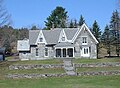
Plymouth is a town in Windsor County, Vermont, United States. The population was 641 at the 2020 census. Calvin Coolidge, the 30th President of the United States, was born and raised in Plymouth and is buried there as well. The State of Vermont Division for Historic Preservation owns and maintains the Coolidge Homestead and the village of Plymouth Notch.

<span class="mw-page-title-main">Reading, Vermont</span> Town in Vermont, United States

Reading is a town in Windsor County, Vermont, United States. The population was 687 at the 2020 census.

<span class="mw-page-title-main">Rochester, Vermont</span> Town in Vermont

Rochester is a town in Windsor County, Vermont, United States. The population was 1,099 at the 2020 census. The central village is delineated as the Rochester census-designated place.

<span class="mw-page-title-main">Stockbridge, Vermont</span> Town in Vermont, United States

Stockbridge is a town in Windsor County, Vermont, United States, which contains the village of Gaysville. The population was 718 at the 2020 census. Stockbridge was one of thirteen Vermont towns isolated by flooding caused by Hurricane Irene in 2011.

<span class="mw-page-title-main">West Windsor, Vermont</span> Town in Vermont, United States

West Windsor is a town in Windsor County, Vermont, United States. The population was 1,344 at the 2020 census. It was known for its Ascutney Mountain Resort, which closed in 2010 and was bought by its citizens in 2015.

<span class="mw-page-title-main">Weston, Vermont</span> Town in Vermont, United States

Weston is a town in Windsor County, Vermont, United States. The population was 623 at the 2020 census. Home to the Weston Playhouse Theatre Company, it includes the villages of Weston and The Island.

<span class="mw-page-title-main">St. Germain, Wisconsin</span> Town in Wisconsin, United States

St. Germain is a town in Vilas County, Wisconsin, United States. The population was 1,932 at the 2000 census. The unincorporated community of St. Germain is located in the town.

<span class="mw-page-title-main">Ludlow (town), Vermont</span> Town in Vermont, United States

Ludlow is a town in Windsor County, Vermont, United States. The population was 2,172 at the 2020 census. Ludlow is the home of Okemo Mountain, a popular ski resort. Before becoming a ski destination, Ludlow was originally a mill town, and was the home of a General Electric plant until 1977. It was named after Ludlow, Massachusetts which is less than 100 miles away. There is also a village of Ludlow in the town.

<span class="mw-page-title-main">West Rutland, Vermont</span> Town in Vermont, United States

West Rutland is a town in Rutland County, Vermont, United States. The population was 2,214 at the 2020 census. The town center, located in the south-central portion of the town and where about 87% of the population resides, is defined by the U.S. Census Bureau as a census-designated place (CDP). The town is part of the Rutland micropolitan NECTA.

References

  1. 1 2 "U.S. Census website". United States Census Bureau . Retrieved January 31, 2008.
  2. "US Board on Geographic Names". United States Geological Survey. October 25, 2007. Retrieved January 31, 2008.
  3. "Cavendish" in The Vermont Encyclopedia (eds. John J. Duffy, Samuel B. Hand & Ralph H. Orth: University of Vermont Press, 2003), p. 79.
  4. "Profile of General Population and Housing Characteristics: 2020 Demographic Profile Data (DP-1): Cavendish town, Windsor County, Vermont". United States Census Bureau . Retrieved December 8, 2021.
  5. "History of Cavendish". Cavendish Historical Society. Archived from the original on July 13, 2011. Retrieved March 25, 2011.
  6. "Cavendish 05142". Virtual Vermont. Retrieved March 25, 2011.
  7. "Cavendish Semiquincentennial: First Settlers". Cavendish Historical Society. Retrieved March 25, 2011.
  8. "Geographic Identifiers: 2010 Demographic Profile Data (G001): Cavendish town, Windsor County, Vermont". United States Census Bureau . Retrieved July 30, 2012.
  9. Floodwaters From Storm Isolate 13 Vermont Towns, The New York Times
  10. "Cavendish, Vermont Köppen Climate Classification (Weatherbase)". Weatherbase.
  11. "Cavendish, Vermont 1991-2020 Monthly Normals" . Retrieved October 28, 2023.
  12. "xmACIS". National Oceanic and Atmospheric Administration. Retrieved October 28, 2023.
  13. "U.S. Decennial Census". United States Census Bureau. Retrieved May 16, 2015.
  14. 'Wisconsin Blue Book 1882,' Biographical Sketch of William Henry Proctor, pg. 542