Royalton, Vermont

Last updated
Royalton, Vermont
Town
South royalton vermont 20040927.jpg
Village of South Royalton from Interstate 89
Windsor County Vermont incorporated and unincorporated areas Royalton highlighted.svg
Location in Windsor County and the state of Vermont.
Coordinates: 43°48′58″N72°32′50″W / 43.81611°N 72.54722°W / 43.81611; -72.54722 Coordinates: 43°48′58″N72°32′50″W / 43.81611°N 72.54722°W / 43.81611; -72.54722
Country United States
State Vermont
County Windsor
Chartered1769
Settled1771
Organized1774
Area
  Total40.9 sq mi (106.0 km2)
  Land40.4 sq mi (104.7 km2)
  Water0.5 sq mi (1.3 km2)
Elevation
492 ft (150 m)
Population
 (2020)
  Total2,750
  Density67/sq mi (26/km2)
Time zone UTC-5 (EST)
  Summer (DST) UTC-4 (EDT)
ZIP code
05068
Area code 802
FIPS code 50-60850 [1]
GNIS feature ID1462191 [2]
Website www.royaltonvt.com

Royalton is a town in Windsor County, Vermont, United States. The population was 2,750 at the 2020 census. [3] It includes the villages of Royalton, South Royalton, and North Royalton. Vermont Law School, the state's only accredited law school, is located in South Royalton.

Contents

History

Logging scene c. 1907 Getting Out Logs Near South Royalton, VT.jpg
Logging scene c.1907

The town was chartered on November 23, 1769 by Cadwallader Colden, Royal Lieutenant Governor of New York. The first permanent settlers were Robert Havens and his family, who arrived in 1771. Royalton was re-chartered by the Independent Republic of Vermont on December 20, 1781. The 1780 Royalton Raid was the last major British raid of the American War of Independence in New England. In 1848, the Vermont Central Railroad opened to South Royalton, which developed as a freight depot.

During the Revolutionary War Royalton was visited by Gilbert du Motier, Marquis de Lafayette

Although Joseph Smith, founder of Mormonism, was born in the adjacent town of Sharon near the Royalton boundary, the Joseph Smith Birthplace Memorial lies in the town. [4]

In June 1974, the now-defunct Royalton College hosted the Institute for Humane Studies' Conference on Austrian Economics. The conference is considered the "single most important catalyst in this revival of Austrian economics", an economic theory also known as "The Austrian School", the "Vienna School" or the "Psychological School". Edwin G. Dolan hosted the conference. Notable presenters included Israel M. Kirzner, Ludwig M. Lachmann, and Murray N. Rothbard. The edited version of the conference proceedings appears in Professor Dolan's The Foundations of Modern Austrian Economics. [5] [6]

A landscape photo of Royalton stands in as the fictional town of Stars Hollow in the opening credits of Gilmore Girls . In the mid-20th-century, Royalton had an economy largely built around lumbering, dairy production, poultry raising, the raising of fresh produce vegetables and maple sugar production. [7]

Geography

The town is located on the east side of the Green Mountains, and the White River cuts through its center. According to the United States Census Bureau, the town has a total area of 40.9 square miles (106.0 km2), of which 40.4 square miles (104.7 km2) is land and 0.5 square mile (1.3 km2) (1.25%) is water.

The town is crossed by Interstate 89 and Vermont routes 14, 107 and 110. It is bordered by the town of Bethel to the northwest, Randolph to the north, Tunbridge to the northeast, Strafford to the east, Sharon to the southeast, Pomfret to the south, and Barnard to the southwest.

Demographics

Historical population
CensusPop.Note
1790 748
1800 1,501100.7%
1810 1,75316.8%
1820 1,8163.6%
1830 1,8934.2%
1840 1,9171.3%
1850 1,850−3.5%
1860 1,739−6.0%
1870 1,679−3.5%
1880 1,558−7.2%
1890 1,433−8.0%
1900 1,427−0.4%
1910 1,4521.8%
1920 1,4691.2%
1930 1,4911.5%
1940 1,291−13.4%
1950 1,3313.1%
1960 1,3884.3%
1970 1,3990.8%
1980 2,10050.1%
1990 2,38913.8%
2000 2,6039.0%
2010 2,7736.5%
2020 2,750−0.8%
U.S. Decennial Census [8]

As of the census [1] of 2000, there were 2,602 people, 1,155 households, and 622 families residing in the town. The population density was 64.4 people per square mile (24.9/km2). There were 1,281 housing units at an average density of 31.7 per square mile (12.2/km2). The racial makeup of the town was 97.20% White, 0.77% African American, 0.42% Native American, 0.77% Asian, and 0.85% from two or more races. Hispanic or Latino of any race were 0.88% of the population.

There were 1,155 households, out of which 26.5% had children under the age of 18 living with them, 43.8% were couples living together and joined in either marriage or civil union, 6.8% had a female householder with no husband present, and 46.1% were non-families. 34.5% of all households were made up of individuals, and 7.3% had someone living alone who was 65 years of age or older. The average household size was 2.24 and the average family size was 2.95.

In the town, the population was spread out, with 22.3% under the age of 18, 10.5% from 18 to 24, 35.5% from 25 to 44, 20.9% from 45 to 64, and 10.8% who were 65 years of age or older. The median age was 34 years. For every 100 females, there were 102.7 males. For every 100 females age 18 and over, there were 98.7 males.

The median income for a household in the town was $30,943, and the median income for a family was $42,898. Males had a median income of $29,708 versus $26,667 for females. The per capita income for the town was $16,755. About 7.6% of families and 15.0% of the population were below the poverty line, including 9.3% of those under age 18 and 11.6% of those age 65 or over.

2010 census

As of the 2010 census Royalton had a population of 2,773. The median age was 36.

The population was 94.4% non-Hispanc white, 0.9% black, 0.4% Native American, 1.2% Asian, 0.1% Pacific Islander, 0.1% reporting some other race, 1.7% reporting two or more races and 1.5% Hispanic or Latino. [9]

Sites of interest

Notable people

Village of South Royalton South royalton vermont 20040808.jpg
Village of South Royalton

Related Research Articles

<span class="mw-page-title-main">Windsor County, Vermont</span> County in Vermont, United States

Windsor County is a county located in the U.S. state of Vermont. As of the 2020 census, the population was 57,753. The shire town is the town of Woodstock. The county's largest municipality is the town of Hartford.

<span class="mw-page-title-main">Hartland, New York</span> Town in New York, United States

Hartland is a town in Niagara County, New York, United States. The population was 4,117 at the 2010 census. The town is named after Hartland, Vermont, the homeplace of some early settlers.

<span class="mw-page-title-main">Royalton, New York</span> Town in New York, United States

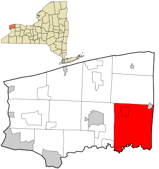
Royalton is a town in Niagara County, New York, United States. The population was 7,660 at the 2010 census.

<span class="mw-page-title-main">Cornwall, Vermont</span> Town in Vermont, United States

Cornwall is a town in Addison County, Vermont, United States. It was founded November 3, 1761. The population was 1,207 at the 2020 census.

<span class="mw-page-title-main">New Haven, Vermont</span> Town in Vermont, United States

New Haven is a town in Addison County, Vermont, United States. The population was 1,683 at the 2020 census. In addition to the town center, New Haven contains the communities of Belden, Brooksville, New Haven Junction and New Haven Mills.

<span class="mw-page-title-main">Shoreham, Vermont</span> Town in Vermont, United States

Shoreham is a town in Addison County, Vermont, United States. The population was 1,260 at the 2020 census.

<span class="mw-page-title-main">Weybridge, Vermont</span> Town in Vermont, United States

Weybridge is a town in Addison County, Vermont, United States. The population was 814 at the 2020 census.

<span class="mw-page-title-main">Whiting, Vermont</span> Town in Vermont, United States

Whiting is a town in Addison County, Vermont, United States. The town was named for John Whiting, a landholder. The population was 405 at the 2020 census.

<span class="mw-page-title-main">Shaftsbury, Vermont</span> Town in Vermont, United States

Shaftsbury is a town in Bennington County, Vermont, United States. The population was 3,598 at the 2020 census.

<span class="mw-page-title-main">Morristown, Vermont</span> Town in Vermont, United States

Morristown is a town in Lamoille County, Vermont, United States. As of the 2020 census, the population was 5,434. Morristown is the largest town by population in Lamoille County, and its central village of Morrisville serves as the county's main commercial center.

<span class="mw-page-title-main">Strafford, Vermont</span> Town in Vermont, United States

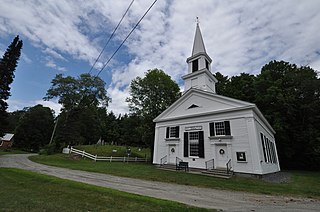
Strafford is a town in Orange County, Vermont, United States. The population was 1,094 at the 2020 census. The town of Strafford was created on August 12, 1761 by way of a royal charter which King George III of Great Britain issued to Governor Benning Wentworth of New Hampshire. The town was named after the Earl of Strafford. Its town house is one of the most famous in Vermont, sitting atop a hill in the historic town square.

<span class="mw-page-title-main">West Fairlee, Vermont</span> Town in Vermont, United States

West Fairlee is a town in Orange County, Vermont, United States. The population was 621 at the 2020 census.

<span class="mw-page-title-main">Williamstown, Vermont</span> Town in Vermont, United States

Williamstown is a town in Orange County, Vermont, United States. The population was 3,515 at the 2020 census, making it the second largest municipality in the county.

<span class="mw-page-title-main">Bethel, Vermont</span> Town in Vermont, United States

Bethel is a town in Windsor County, Vermont, United States. The population was 1,942 at the 2020 census. The town includes the locations of Bethel village, Bethel-Gilead, East Bethel, Lilliesville, Lympus, and West Bethel. Bethel is best known for being the source of Bethel White granite which was used to build Union Station and the National Museum of Natural History. Bethel was the first town created by the independent Republic of Vermont in 1779 and was named after the Biblical village of Bethel.

<span class="mw-page-title-main">Hartford, Vermont</span> Town in Vermont, United States

Hartford is a town in Windsor County, Vermont, United States. It is on the New Hampshire border, at the intersection of Interstates 89 and 91. It is the site of the confluence of the White and Connecticut rivers; the Ottauquechee River also flows through the town. The town is composed of five unincorporated villages: Hartford, Quechee, West Hartford, White River Junction and Wilder. As of the 2020 census, the population was 10,686.

<span class="mw-page-title-main">Sharon, Vermont</span> Town in Vermont, United States

Sharon is a town in Windsor County, Vermont, United States. It had a population of 1,560 at the 2020 census.

<span class="mw-page-title-main">Royalton, Wisconsin</span> Town in Wisconsin, United States

Royalton is a town in Waupaca County, Wisconsin, United States. The population was 1,523 at the 2000 census. The unincorporated communities of Baldwins Mill and Royalton are located in the town.

<span class="mw-page-title-main">Royalton, Minnesota</span> City in Minnesota, United States

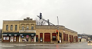
Royalton is a city in Morrison and Benton counties in the U.S. state of Minnesota, along the Platte River. The population was 1,281 at the 2020 census. The city is located mainly within Morrison County.

<span class="mw-page-title-main">Westminster (town), Vermont</span> Town in Vermont, United States

Westminster is a town in Windham County, Vermont, United States. The population was 3,016 at the 2020 census. It is also the first capital of the Republic of Vermont. It borders the state of New Hampshire.

<span class="mw-page-title-main">Rutland, Vermont (town)</span> Town in Vermont, United States

Rutland is a town in Rutland County, Vermont, in the United States. As of the 2020 census, the population was 3,924. The Town of Rutland completely surrounds the City of Rutland, which is incorporated separately from the town. The villages of the town effectively comprise the inner suburbs of the City of Rutland.

References

  1. 1 2 "U.S. Census website". United States Census Bureau . Retrieved 2008-01-31.
  2. "US Board on Geographic Names". United States Geological Survey. 2007-10-25. Retrieved 2008-01-31.
  3. "Census - Geography Profile: Royalton town, Windsor County, Vermont". United States Census Bureau . Retrieved January 4, 2022.
  4. Joseph Smith, Jr. Monument Archived 2006-11-09 at archive.today , Mormon Historic Sites Registry, c. 2006. Accessed 2008-04-09.
  5. "Remembrance and Appreciation Roundtable Professor Ludwig M. Lachinann - 1906-1990 - Obituary | American Journal of Economics and Sociology, The | Find Articles at BNET.com". Archived from the original on 12 June 2008. Retrieved 2022-07-18.
  6. "Online Library of Liberty". Oll.libertyfund.org. Retrieved 2022-07-18.
  7. Columbia-Lippincott Gazetter, 1952 edition, p. 1608
  8. "U.S. Decennial Census". United States Census Bureau. Retrieved May 16, 2015.
  9. 2010 census report on Royalton
  10. "Death Notice, Franklin Noble Billings". Vermont Standard . Woodstock, VT. December 20, 1894. p. 1 via Newspapers.com.