Chappaqua station

Last updated

Chappaqua
Chappaqua, NY, train station.jpg
View north from platform, 2009, with historic station on right
General information
Location108 Allen Place, Chappaqua, New York
Line(s) Harlem Line
Platforms1 island platform
Tracks2
Connections Bee-Line : 19
Construction
Parking1,416 spaces
AccessibleYes
Other information
Fare zone5
History
OpenedJune 1, 1847 [1] [2]
RebuiltJune 14, 1902 [3]
2007
Electrified1984
700V (DC) third rail
Previous namesChapequa
Passengers
20182,038 [4] (Metro-North)
Rank30 of 109 [4]
Services
Preceding station MTA NYC logo.svg Metro-North Railroad Following station
Pleasantville Harlem Line Mount Kisco
toward Southeast
Former services
Preceding station New York Central Railroad Following station
Pleasantville
toward New York
Harlem Division Mount Kisco
toward Chatham
Chappaqua Railroad Depot and Depot Plaza
Coordinates 41°9′28.44″N73°46′29.64″W / 41.1579000°N 73.7749000°W / 41.1579000; -73.7749000
Area2.7 acres (1 ha)
Built1902
ArchitectNicholas Grant [5]
Architectural style Richardsonian Romanesque
MPS Horace Greeley Related Sites TR
NRHP reference No. 79003210 [6]
Added to NRHPApril 19, 1979
Location
Chappaqua station

Chappaqua station is a commuter rail stop on the Metro-North Railroad's Harlem Line, located in Chappaqua, New York, United States, within the town of New Castle.

Contents

Next to the modern station is the building opened by the New York Central Railroad in 1902. [7] Still in use as a waiting area, it is part of the Chappaqua Railroad Depot and Depot Plaza listed on the National Register of Historic Places since 1979. [8] It was built on land donated by the daughter of Horace Greeley, a prominent newspaper editor and presidential candidate who had moved to Chappaqua in the mid-19th century and been responsible for much of its early development, on the condition that a small park adjacent to the station be maintained. [9]

History

Chappaqua was first settled by Quakers moving inland from Long Island Sound in the 1740s. For a century after that, it remained a self-sustaining farming community, centered around the meeting house 0.6 mile (1 km) north of the present downtown along Quaker Road. The meeting house and several other buildings remain from that era. They are now part of the Old Chappaqua Historic District, also listed on the National Register. [10]

In 1846 the New York and Harlem Railroad laid the first tracks along the current route. That led to gradual changes in the economy and geography of Chappaqua. Farmers could now easily ship their crops to New York for sale, and many switched to growing cash crops to take advantage of this. A few businesses began to cluster around the original depot site, a few hundred feet north of the present station. [9] Three buildings were eventually built close to the station. [11]

The rail connection made it possible for those with social and commercial links to the city to maintain them, and some who had business there moved to Chappaqua. Among them was Horace Greeley, the crusading editor of the New York Tribune . He settled there with his wife and daughter in 1853, seeking a quiet country retreat from the demands of his job and a place to test the farming methods he advocated. Shortly after moving in he built the first concrete dairy barn in the country. In 1864 he bought a large farm south of the station and expanded its farmhouse. He lived there for the last nine years of his life. [12]

His daughter Gabrielle inherited the farm. Over the remaining years of the 19th century more city residents followed her family's lead and moved out to Chappaqua. They often settled on farms that had been subdivided into large residential lots. By the turn of the century the 1846 depot was no longer able to handle its daily passenger and freight traffic, and the existing buildings were preventing easy access to the station. As sites for a new depot were being proposed and considered, with considerable opposition from the owners of the three buildings near the old station,. [11] Gabrielle offered to donate the 2.7 acres (1.1 ha) where it presently stands for a station, a public park to always be maintained there, and an access road to be named Woodbine Avenue after her mother's family. [9]

Her offer was accepted, and the station was built there. It was completed and opened in 1902, amid much local celebration. Its completion triggered the development of most of modern downtown Chappaqua, and accelerated the suburbanization of the community, as Gabrielle Greeley continued to subdivide the remnants of the farm for development by others until her death in 1937. The small park, decorated with a statue of her father and war memorial in 1914, remained per the stipulation of her original gift. [12]

In the early 1970s the Penn Central Railroad, successor by merger to the New York Central Railroad, which had absorbed the New York and Harlem, went bankrupt. Commuter rail services it had operated were first run by Conrail, then by Metro-North Railroad after that agency was created under the aegis of New York's Metropolitan Transportation Authority (MTA). During the 1980s the new station, with elevated platforms, was built. Café La Track was opened in the old station a decade later. [13]

In the early 2000s, 20 spaces in the station's lot were equipped with plug-in recharging stations for electric cars as part of a pilot program to encourage their use. Drivers of those vehicles were guaranteed access to one of those spaces. [14] Three years later, during a $1.1 million renovation of the station, the owners of Café La Track, which occupied the southwestern corner of the station building, resorted to an online petition to successfully prevent themselves from being replaced by a Dunkin' Donuts franchise. [13]

The historic station building was converted into a restaurant, Chappaqua Station, in 2015, while retaining much of the station's original character. [15] As of 2019, the station is occupied by Bobo's Cafe. [16]

Station layout

The station has one eight-car-long high-level island platform serving trains in both directions. [17] :12

Buildings and grounds

Original 1902 station depot at Chappaqua
Chappaqua Depot House.png
Exterior of the depot
Chappaqua historic station interior.jpg
Interior of the depot prior to being converted to a restaurant

The station is located on the southwest corner of downtown Chappaqua, located in a low area amid hilly terrain just north of the Mount Pleasant town line. At that point the two railroad tracks run straight in a northeast-southwest heading, paralleling the Saw Mill River Parkway and the headwaters of the eponymous stream immediately to their west. [18] Quaker Road (New York State Route 120) crosses over the tracks just north of the station, east of its interchange with the parkway. Beyond the Quaker Road bridge, a parking lot separates the road from the main commercial area of downtown around the intersection of King Street, South Greeley Avenue, and North Greeley Avenue. [19]

East of the station, across South Greeley Avenue, are commercial buildings north of Woodburn Avenue and Robert E. Bell Middle School of the Chappaqua Central School District. South of it is the Episcopal Church of St. Mary the Virgin, also listed on the Register due to its connection to the Greeley family. A baseball diamond lies between the station and New Castle's town hall and the Chappaqua library on the south. To the southwest of the station its overflow parking spills out alongside the tracks to the town line. [19]

Woodburn Avenue west of South Greeley serves as the station's entrance road. Parking is in concentric semicircles, mirroring the small park just east of the station. A statue of Greeley and war memorial are located just across Allen Place from the historic station building on the east side of the tracks. [9] The entry stairs to the modern station are immediately to the south. [20]

The historic building is a one-story fieldstone structure with a tiled hipped roof pierced at either end by two stone chimneys. On its west side, opposite the statue and war memorial, is a gabled porte-cochère supported by square bracketed wooden pillars atop a stone wall. West, along the tracks, a roofed arcade extends along the tracks. It is no longer necessary as a shelter for passengers awaiting trains since the tracks are now fenced off on that side and all ingress and egress from them is via the modern station. [9]

A walkway and steps enclosed with glass and aluminum climb to a similarly treated overpass from both north and south, with an elevator in a brick shaft between them. In the overpass are ticket machines, on the west end of the overpass, another enclosed stairwell and another elevator in a brick shaft descend to the elevated concrete island platform between the tracks. [20]

The platform, long enough to accommodate eight cars, extends about 50 feet (15 m) to the south of the overpass. North of the overpass it continues to slightly north of the Quaker Road overpass. A roof covers the first hundred feet (30 m). Along its length are ornate metal streetlights, enclosed shelters, and some vending machines. [20]

The historic station was converted to a café in 2015. While the ticket counter closed, the cafe retains most of the station's original elements, including the waiting area benches and the original ticket counter, which serves as a check-out counter. [21] It is decorated entirely in wood, from the flooring to the vertical siding to the exposed ceiling rafters. There is a simple molding at the floor, and a more decorative one at the chair rail level and then running around the waiting room at the top of the entryways, all of which are flanked by smooth square pilasters. Above that level is a paneled entablature (with ten-pane horizontal casement windows above the former ticket office), with another molded cornice at the ceiling.

See also

Notes

  1. Dana 1866, p. 216.
  2. "New York and Harlem Railroad ---- Winter Arrangement". The Evening Post. New York, New York. December 12, 1849. p. 4. Retrieved December 12, 2019 via Newspapers.com. Open Access logo PLoS transparent.svg
  3. "Chappaqua's Gala Day". The New York Tribune. June 16, 1902. p. 3. Retrieved July 25, 2022 via Newspapers.com. Open Access logo PLoS transparent.svg
  4. 1 2 METRO-NORTH 2018 WEEKDAY STATION BOARDINGS. Market Analysis/Fare Policy Group:OPERATIONS PLANNING AND ANALYSIS DEPARTMENT:Metro-North Railroad. April 2019. p. 6.
  5. "Westchester County Listings". National Register of Historic Places.
  6. "National Register Information System". National Register of Historic Places . National Park Service. July 9, 2010.
  7. "Chappaqua's Gala Day". New York Daily Tribune. June 16, 1902 via I Ride the Harlem Line.com.
  8. "People, Parks & Fire exhibit at the National Association for Interpretation Conference in Virginia Beach, Virginia in November, 2002". National Register of Historic Places. Archived from the original on February 20, 2013.
  9. 1 2 3 4 5 Gruber, Walter J.; Gruber, Dorothy W. (August 28, 1977). "National Register of Historic Places nomination, Chappaqua Railroad Depot and Depot Plaza". New York State Office of Parks, Recreation and Historic Preservation. Archived from the original on March 4, 2016. Retrieved April 2, 2013.
  10. Weaver, Lynn Beebe (October 1973). "National Register of Historic Places Registration: Old Chappaqua Historic District". New York State Office of Parks, Recreation and Historic Preservation. Archived from the original on October 18, 2012. Retrieved April 3, 2013.
  11. 1 2 "Chappaqua Railway Station Cut Off" (PDF). The New York Times. August 15, 1901. Retrieved April 4, 2013.
  12. 1 2 Gruber, Walter; Gruber, Dorothy (October 14, 1978). "Horace Greeley Related Sites Thematic Resources". U.S. National Park Service. Retrieved April 3, 2013.
  13. 1 2 Scharfenberg, David (January 9, 2005). "In Chappaqua, Shop Regains Its Toehold". The New York Times. Retrieved April 7, 2013.
  14. Callahan, Tom (February 24, 2002). "Station Cars, Batteries And Parking Included". The New York Times. Retrieved April 7, 2013.
  15. Connolly, Colette (February 2, 2016). "Business of the Week: Chappaqua Station, Chappaqua". The Examiner. Retrieved January 6, 2020.
  16. Wilbur, Martin (July 1, 2019). "Chappaqua Train Station Cafe Owners to Sell Operation". Examiner Media. The Examiner. Retrieved January 6, 2020.
  17. "Metro-North Railroad Track & Structures Department Track Charts Maintenance Program Interlocking Diagrams & Yard Diagrams 2015" (PDF). Metro-North Railroad. 2015. Retrieved January 28, 2019.
  18. Ossining Quadrangle — New York — Westchester Co (Map). 1:24,000. USGS 7½-minute quadrangles. U.S. Geological Survey. Retrieved April 6, 2013.
  19. 1 2 Google (April 6, 2013). "Allen Pl" (Map). Google Maps . Google. Retrieved April 6, 2013.
  20. 1 2 3 Microsoft; Nokia (April 6, 2013). "Chappaqua (Metro-North station)" (Map). Bing Maps . Microsoft. Retrieved April 6, 2013.
  21. "Chappaqua Station Farm to Town Opens". What to Do Armonk, Bedford and Chappaqua. What To Do Media. Retrieved January 6, 2020.

Related Research Articles

<span class="mw-page-title-main">Chappaqua, New York</span> Hamlet and census-designated place in New Castle, New York, US

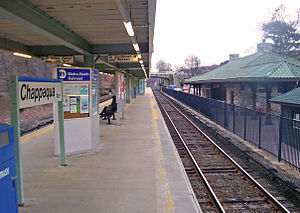
Chappaqua is a hamlet and census-designated place in the town of New Castle, in northern Westchester County, New York. It is approximately 30 miles (50 km) north of New York City. The hamlet is served by the Chappaqua station of the Metro-North Railroad's Harlem Line. In the New York State Legislature it is within the New York State Assembly's 93rd district and the New York Senate's 40th district. In Congress the village is in New York's 17th District.

The Bronx River Parkway is a 19.12-mile (30.77 km) limited-access parkway in downstate New York in the United States. It is named for the nearby Bronx River, which it parallels. The southern terminus of the parkway is at Story Avenue near the Bruckner Expressway in the Bronx neighborhood of Soundview. The northern terminus is at Kensico Circle in North Castle, Westchester County, where the parkway connects to the Taconic State Parkway and via a short connector, New York State Route 22 (NY 22). Within the Bronx, the parkway is maintained by the New York State Department of Transportation and is designated New York State Route 907H (NY 907H), an unsigned reference route. In Westchester County, the parkway is maintained by the Westchester County Department of Public Works and is designated unsigned County Route 9987 (CR 9987).

<span class="mw-page-title-main">Park Avenue</span> North–south avenue in Manhattan and the Bronx, New York

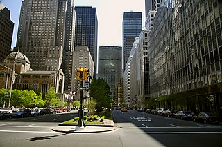
Park Avenue is a boulevard in New York City that carries north and southbound traffic in the boroughs of Manhattan and the Bronx. For most of the road's length in Manhattan, it runs parallel to Madison Avenue to the west and Lexington Avenue to the east. Park Avenue's entire length was formerly called Fourth Avenue; the title still applies to the section between Cooper Square and 14th Street. The avenue is called Union Square East between 14th and 17th Streets, and Park Avenue South between 17th and 32nd Streets.

<span class="mw-page-title-main">Garrison station (Metro-North)</span> Metro-North Railroad station in New York

Garrison station is a commuter rail stop on the Metro-North Railroad's Hudson Line, located in Philipstown, New York.

<span class="mw-page-title-main">Millwood, New York</span> Hamlet & CDP in New York, United States

Millwood is a hamlet and census-designated place located in the town of New Castle, New York, United States in Westchester County. It was originally settled as Sarlesville. The area now known as Millwood appears on 19th century maps as Merritt's Corners and Rockdale Mills. As of the 2000 census, the community had a population of 1,210.

<span class="mw-page-title-main">Scarsdale station</span> Metro-North Railroad station in New York

Scarsdale station is a commuter rail stop on the Metro-North Railroad's Harlem Line, located in Scarsdale, New York. Scarsdale is the southernmost station on the two-track section of the Harlem Line; a third track begins to the south.

<span class="mw-page-title-main">Fordham station</span> Metro-North Railroad station in the Bronx, New York

Fordham station, also known as Fordham–East 190th Street station, is a commuter rail stop on the Metro-North Railroad's Harlem and New Haven Lines, serving Fordham Plaza in the Fordham neighborhood of the Bronx, New York City. The platforms are situated just below street level and feature two expanded side platforms that serve eight cars each, on the outer tracks. The station building sits above the tracks on the Fordham Road overpass, and still bears the name New York Central Railroad on its facade. The station is among the busiest rail stations in the Bronx.

<span class="mw-page-title-main">Harlem Line</span> Metro-North Railroad line in New York

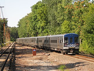
The Harlem Line is an 82-mile (132 km) commuter rail line owned and operated by the Metro-North Railroad in the U.S. state of New York. It runs north from New York City to Wassaic, in eastern Dutchess County. The lower 53 miles (85 km) from Grand Central Terminal to Southeast, in Putnam County, is electrified with a third rail and has at least two tracks. The section north of Southeast is a non-electrified single-track line served by diesel locomotives. Before the renaming of the line in 1983, it eventually became the Harlem Division of the New York Central Railroad. The diesel trains usually run as a shuttle on the northern end of the line, except for rush-hour express trains in the peak direction.

<span class="mw-page-title-main">Hudson Line (Metro-North)</span> Metro-North Railroad line in New York

The Hudson Line is a commuter rail line owned and operated by the Metro-North Railroad in the U.S. state of New York. It runs north from New York City along the east shore of the Hudson River, terminating at Poughkeepsie. The line was originally the Hudson River Railroad, and eventually became the Hudson Division of the New York Central Railroad. It runs along what was the far southern leg of the Central's famed "Water Level Route" to Chicago.

<span class="mw-page-title-main">Fanwood station</span> NJ Transit rail station

Fanwood is a New Jersey Transit railroad station on the Raritan Valley Line, in Fanwood, Union County, New Jersey, United States. The building on the north side of the tracks is a Victorian building and, like the north building at Westfield, is used by a non-profit organization. The address is Fanwood Station, 238 North Avenue, Fanwood, Union County, New Jersey. The ticket office is in the station building on the south side of the tracks. The station was added to the National Register of Historic Places on July 17, 1980.

<span class="mw-page-title-main">Hartsdale station</span> Metro-North Railroad station in New York

Hartsdale station is a commuter rail station on the Metro-North Railroad Harlem Line, located in the Hartsdale hamlet of Greenburgh, New York.

<span class="mw-page-title-main">New York State Route 120</span> State highway in Westchester County, New York, US

New York State Route 120 (NY 120) is a state highway in southern Westchester County, New York, in the United States. It begins in the city of Rye at an intersection with U.S. Route 1 (US 1) and runs for about 18 miles (29 km) north to the hamlet of Millwood, where it ends at a junction with NY 100. The route intersects with Interstate 684 (I-684) and the Saw Mill River Parkway, and serves the Westchester County Airport in North Castle. Portions of the route have been signed ceremonially in remembrance of American serviceman killed in the 2000s and 2010s during the wars in Iraq and Afghanistan.

<span class="mw-page-title-main">Fairfield station (Metro-North)</span> Metro-North Railroad station in Connecticut

Fairfield station is a commuter rail station on the Metro-North Railroad New Haven Line, located in Fairfield, Connecticut. The former station buildings are listed on the National Register of Historic Places as Fairfield Railroad Stations.

<span class="mw-page-title-main">Park Avenue main line</span> Railroad line in New York City

The Park Avenue main line, which consists of the Park Avenue Tunnel and the Park Avenue Viaduct, is a railroad line in the New York City borough of Manhattan, running entirely along Park Avenue. The line carries four tracks of the Metro-North Railroad as a tunnel from Grand Central Terminal at 42nd Street to a portal at 97th Street, where it rises to a viaduct north of 99th Street and continues over the Harlem River into the Bronx over the Park Avenue Bridge. During rush hours, Metro-North uses three of the four tracks in the peak direction.

<span class="mw-page-title-main">New York, Westchester and Boston Railway</span> Former U.S. railway company

The New York, Westchester and Boston Railway Company, was an electric commuter railroad in the Bronx and Westchester County, New York from 1912 to 1937. It ran from the southernmost part of the South Bronx, near the Harlem River, to Mount Vernon with branches north to White Plains and east to Port Chester. From 1906, construction and operation was under the control of the New York, New Haven & Hartford Railroad (NH) until its bankruptcy in 1935.

<span class="mw-page-title-main">Church of Saint Mary the Virgin (Chappaqua, New York)</span> Historic church in New York, United States

The Church of Saint Mary the Virgin is an Episcopal church located on South Greeley Avenue in Chappaqua, New York, United States. It was built in the early years of the 20th century on land donated by Horace Greeley's daughter Gabrielle and her husband, himself a priest of the Episcopal Church. In 1979 it was one of several properties associated with Greeley in Chappaqua listed on the National Register of Historic Places as the Church of Saint Mary Virgin and Greeley Grove.

<span class="mw-page-title-main">Greeley House (Chappaqua, New York)</span> Historic house in New York, United States

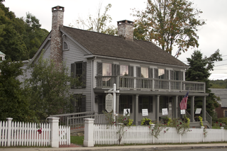
The Greeley House is located at King and Senter streets in downtown Chappaqua, New York, United States. It was built about 1820 and served as the home of newspaper editor and later presidential candidate Horace Greeley from 1864 to his death in 1872. In 1979 it was listed on the National Register of Historic Places along with several other properties nearby related to Greeley and his family.

<span class="mw-page-title-main">Rehoboth (Chappaqua, New York)</span> United States historic place

Rehoboth is a historic former barn located on Aldridge Road in Chappaqua, New York, United States. It is a concrete structure that has been renovated into a house with some Gothic Revival decorative elements. In 1979 it was listed on the National Register of Historic Places.

<span class="mw-page-title-main">Old Chappaqua Historic District</span> Area of Chappaqua, New York, first settled by Quakers

The Old Chappaqua Historic District is located along Quaker Road in the town of New Castle, New York, United States, between the hamlets of Chappaqua and Millwood. It was the original center of Chappaqua, prior to the construction of the New York and Harlem Railroad and the erection of its station to the south in the mid-19th century. In 1974 it was recognized as a historic district and listed on the National Register of Historic Places.

<span class="mw-page-title-main">86th Street station (New York Central Railroad)</span> Closed train station in Manhattan, New York

The 86th Street station is an abandoned station located in the Park Avenue Tunnel used by Metro-North Railroad. The station was built by the New York Central & Hudson River Railroad as part of an agreement with New York City. The station was built during the late 19th century. It was located at Park Avenue and 86th Street on the Upper East Side of Manhattan.

References