
Marble Hill station is a commuter rail stop on the Metro-North Railroad's Hudson Line, serving the Marble Hill neighborhood of Manhattan in New York City. The station is located at 125 West 225th Street, two blocks west of the Broadway Bridge on the north side of the Harlem River, near the New York City Subway's Marble Hill–225th Street station.
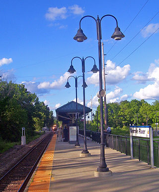
Tenmile River station is a commuter rail stop on the Metro-North Railroad's Harlem Line, located in Amenia, New York.
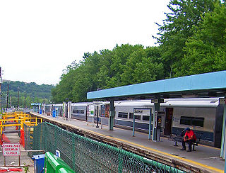
Southeast station is a commuter rail stop on the Metro-North Railroad's Harlem Line, located in Southeast, New York. It is the terminus of the Harlem Line electrified service, and with the exception of rush hour service, passengers heading to stations further north to Wassaic have to transfer here to diesel powered service.

Brewster station is a commuter rail stop on the Metro-North Railroad's Harlem Line, located in Brewster, New York.

Crestwood station is a commuter rail stop on the Metro-North Railroad's Harlem Line, serving the communities of Tuckahoe, Yonkers, and Eastchester, New York. Because of its location at the northern end of the triple-track segment of the Harlem Line, Crestwood is often the first/last stop outside New York City on Harlem Line express trains, and its center island platform is frequently used to short turn local trains during rush hour.

Fordham station, also known as Fordham–East 190th Street station, is a commuter rail stop on the Metro-North Railroad's Harlem and New Haven Lines, serving Fordham Plaza in the Fordham neighborhood of the Bronx, New York City. The platforms are situated just below street level and feature two expanded side platforms that serve eight cars each, on the outer tracks. The station building sits above the tracks on the Fordham Road overpass, and still bears the name New York Central Railroad on its facade. The station is among the busiest rail stations in the Bronx.
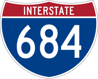
Interstate 684 (I-684) is a 28.53-mile (45.91 km) auxiliary Interstate Highway in the state of New York in the United States. There is also a short portion in Connecticut with no junctions. The highway connects I-84 with I-287 and the Hutchinson River Parkway, primarily serving commuter traffic to and from the northern suburbs of the New York metropolitan area. Most of the route is in northern Westchester County. The route of the highway was originally designated as part of I-87 from 1968 to 1970. The first section of the roadway opened to traffic in October 1968, and the final segment was completed in December 1974.
The Harlem Line is an 82-mile (132 km) commuter rail line owned and operated by the Metro-North Railroad in the U.S. state of New York. It runs north from New York City to Wassaic, in eastern Dutchess County. The lower 53 miles (85 km) from Grand Central Terminal to Southeast, in Putnam County, is electrified with a third rail and has at least two tracks. The section north of Southeast is a non-electrified single-track line served by diesel locomotives. Before the renaming of the line in 1983, it eventually became the Harlem Division of the New York Central Railroad. The diesel trains usually run as a shuttle on the northern end of the line, except for rush-hour express trains in the peak direction.
The New York and Putnam Railroad, nicknamed the Old Put, was a railroad line that operated between the Bronx and Brewster in New York State. It was in close proximity to the Hudson River Railroad and New York and Harlem Railroad. All three came under ownership of the New York Central system in 1894. The railroad was abandoned starting in 1958, and most of the former roadbed has been converted to rail trail use.

The Saw Mill River Parkway is a limited-access parkway that extends for 28.93 miles (46.56 km) through Westchester County, New York, in the United States. It begins at the border between Westchester County and the Bronx, as the continuation of the Henry Hudson Parkway leaving New York City, and heads generally northeastward to an interchange with Interstate 684 (I-684). At its north end, the parkway serves as a collector/distributor road as it passes east of the hamlet of Katonah. The parkway is named for the Saw Mill River, which the highway parallels for most of its length.

The Hudson Line is a commuter rail line owned and operated by the Metro-North Railroad in the U.S. state of New York. It runs north from New York City along the east shore of the Hudson River, terminating at Poughkeepsie. The line was originally the Hudson River Railroad, and eventually became the Hudson Division of the New York Central Railroad. It runs along what was the far southern leg of the Central's famed "Water Level Route" to Chicago.

Croton Falls station is a commuter rail stop on the Metro-North Railroad's Harlem Line, located in North Salem, New York.

Goldens Bridge station is a commuter rail stop on the Metro-North Railroad's Harlem Line, located in Lewisboro, New York.

Pleasantville station is a commuter rail stop on the Metro-North Railroad's Harlem Line, located in Pleasantville, New York. There is also bus service to the station from Pace University.

Hawthorne station is a commuter rail stop on the Metro-North Railroad's Harlem Line, located in Mount Pleasant, New York.
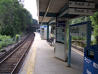
Valhalla station is a commuter rail stop on the Metro-North Railroad's Harlem Line, located in Mount Pleasant, New York.

Botanical Garden station is a commuter rail stop on the Metro-North Railroad's Harlem Line, serving the Bedford Park section of the Bronx, New York City. The station is located just north of the intersection of Southern Boulevard and Bedford Park Boulevard adjacent to northern Bronx Park and the New York Botanical Garden. The station has two high-level side platforms, each eight cars long, that serve the outer tracks of the four-track Harlem Line.

Williams Bridge station is a commuter rail stop on the Metro-North Railroad's Harlem Line, serving the Williamsbridge and Norwood sections of the Bronx, New York City. The station is located at the intersection of Gun Hill Road and Webster Avenue. The station has two offset high-level side platforms, each four cars long, serving the outer tracks of the four-track line.

Woodlawn station is a commuter rail stop on the Metro-North Railroad's Harlem Line, serving the Woodlawn section of the Bronx, New York City. It is located on East 233rd Street near Webster Avenue. Just north of the station is Woodlawn Junction, where the New Haven Line splits from the Harlem Line to join the Northeast Corridor.

Housatonic Area Regional Transit, known popularly as HARTransit, is the provider of public transportation for Danbury, Connecticut and surrounding communities. HARTransit was founded in 1972 as the Danbury-Bethel Transit District by the two municipalities. The name was changed to Housatonic Area Regional Transit in 1979 after the addition of other municipal members. The agency receives funding from municipal contracts, the Connecticut Department of Transportation, Federal Transit Administration and the New York State Department of Transportation. Prior to HARTransit's establishment, Danbury had gone without transit service since 1967 when the privately owned ABC Bus Company which had replaced the Candlewood Bus Company a few months before, ceased operations. The first local bus transit operator in the area, Danbury Power & Transportation Company, operated bus services in Danbury and Bethel from 1926 to 1965. HARTransit provides service to a greater number of towns than its predecessors.


