Chelsea Piers

Last updated

Chelsea Piers as seen from the air. Pier 62 is on the left, with the driving range of Pier 59 partially visible on the right Chelsea Piers.jpg
Chelsea Piers as seen from the air. Pier 62 is on the left, with the driving range of Pier 59 partially visible on the right
Chelsea Piers from the West Side Highway Chelsea-front.jpg
Chelsea Piers from the West Side Highway
Golf club entrance Chelsea Piers golf club jeh.jpg
Golf club entrance

Chelsea Piers is a series of piers in Chelsea, on the West Side of Manhattan in New York City. Located to the west of the West Side Highway (Eleventh Avenue) and Hudson River Park and to the east of the Hudson River, they were originally a passenger ship terminal in the early 1900s that was used by the RMS Lusitania and was the destination of the RMS Carpathia after rescuing the survivors of the RMS Titanic. The piers replaced a variety of run-down waterfront structures with a row of grand buildings embellished with pink granite facades. [1]

Contents

The piers are currently used by the Chelsea Piers Sports & Entertainment Complex. The Complex is a 28-acre waterfront sports village located between 17th and 23rd Streets along Manhattan's Hudson River. This privately financed project opened in 1995. Situated on Piers 59, 60 and 61 and in the head house that connects them, the complex features the Golf Club, a multi-story driving range; the Field House, which contains numerous sports and training facilities; Sky Rink, which has two full-sized ice rinks; the Chelsea Piers Fitness health club; Bowlero at Chelsea Piers, a bowling alley; and Sunset Terrace, a venue that hosts weddings and other events. The complex also includes several event centers; the Studios film and television production facilities; and the Maritime Center marina for mooring private boats.

History

Development and construction

Historically, the term Chelsea Piers referred to the ocean liner berths on Manhattan's west side from 1910 to the 1930s. With ocean liners such as Lusitania becoming larger in size, New York City was looking for a new passenger ship dock in the early 1900s. The Army, which controls the location and size of piers, refused to let any piers extend beyond the existing pierhead line of the North River (the navigation name for the Hudson River south of 30th Street). Ship lines were reluctant to build north of 23rd Street because infrastructure was already in place, including the New York Central railway line and a ferry station near the river at 23rd Street. [2]

Part of the waterfront had been infilled in 1837, extending Manhattan to 13th Avenue, but the city government took over the infilled land and converted most of it into piers. The controversial decision included condemning many businesses. The city was unable to condemn the West Washington Street Market, which remained infilled. The market ultimately closed and the dock was converted to a sanitation facility that was used to load garbage barges headed for the Fresh Kills Landfill. The only section of 13th Avenue that remains is behind the sanitation facility, now a parking lot for sanitation trucks. That section is now called the Gansevoort Peninsula .

The new piers were designed by the architectural firm of Warren and Wetmore, which also designed Grand Central Terminal. Under contracts let by the New York City Department of Dock and Ferries, the Chelsea Section Improvement, as it was officially called, replaced a hodgepodge of run-down waterfront structures with a row of grand buildings embellished with pink granite facades and formed the docking points for the rival Cunard and White Star Lines.

Early 20th century

The RMS Carpathia at Pier 54 after the RMS Titanic rescue Carpathia-54.jpg
The RMS Carpathia at Pier 54 after the RMS Titanic rescue

Most of the major trans-Atlantic liners of the day docked at the piers and they played pivotal roles in the RMS Titanic and RMS Lusitania disasters. The two most memorable moments for the pier were with the Lusitania and Titanic. The RMS Lusitania left her Cunard Pier 54 in 1915 before being torpedoed by German submarine U-20. The RMS Titanic was destined for the White Star pier 59 when she sank. Survivors were rescued on Cunard's RMS Carpathia. The Carpathia dropped off the Titanic's lifeboats at Pier 59 before going back south to Pier 54, where she unloaded the passengers and survivors. Thousands of people assembled at the dock to greet the ship.

During the summer of 1920, a dramatic rally was organized on July 31 at the White Star Line docks. This was to send off Daniel Mannix, the Irish born Archbishop of Melbourne, Australia who had been outspoken on the English rule in Ireland, and successfully led anti conscription campaigns during WW1. A reported 15,000 New Yorkers turned up at Pier 60 at the foot of West 20th street to make sure Lloyd George would allow Mannix passage to Ireland. [3] [4]

A luxury liner row was built between West 44th and West 52nd Street to handle larger liners in the 1930s. After New York moved its luxury liner piers to the New York Cruise Terminal between West 46th and West 54th Street in 1935 to accommodate bigger ships such as the RMS Queen Mary and the SS Normandie, the Chelsea piers became a cargo terminal. During World War II the piers were used to deploy troops. [2] The piers had catastrophic fires in 1932 and 1947 that destroyed some of the south piers. New construction resulted in new cargo piers used by the United States Lines and Grace line.

In July 1936, Jesse Owens and the United States Olympic team depart on the SS Manhattan from Pier 60 for the Summer Games in Berlin, Germany. [5]

Late 20th century

In the 1980s, plans circulated to replace the West Side Elevated Highway with an at grade highway going along the West Side south of 42nd Street. The plan called for the highway to run over demolished piers. The superstructure of Pier 54 was demolished in 1991 except for the archway entrance (along with the White Star and Cunard signage). The plan (dubbed the Westway) was abandoned after court cases said the new highway would jeopardize striped bass.

Following the demise of Westway, development of the West Side Highway evolved into two parts: a public/private partnership that evolved into the upper piers being used for recreational purposes. The southern piers are now part of the Hudson River Park while the northern piers make up the Chelsea Piers Sports & Entertainment Complex. Construction of the complex began on July 12, 1994 in ceremonies attended by New York Governor Mario Cuomo, New York City Mayor Rudy Giuliani, and Manhattan Borough President Ruth Messinger. [1] The complex opened in August 1995. [6]

After the collapse of the World Trade Center due to the September 11 attacks, EMS triage centers were quickly relocated and consolidated at the Chelsea Piers and the Staten Island Ferry Whitehall Terminal. The EMS triage center was shut down and disassembled on September 12, 2001, due to a lack of need. An ad hoc volunteer disaster recovery site was run from Chelsea Piers through September 16, 2001. Volunteers assisted with resources for ground zero recovery volunteers: sleeping area, food, and cell phones.

Chelsea Piers Connecticut, the first expansion project of Chelsea Piers, was built in Stamford, Connecticut. The facility opened in July 2012.

Piers 54/55

The archway is the only remaining identifiable piece of the pier Pier54-2006.jpg
The archway is the only remaining identifiable piece of the pier
Pier 54 in 2012 High Line, New York 2012 48.jpg
Pier 54 in 2012

Pier 54 at 40°44′29″N74°0′36″W / 40.74139°N 74.01000°W / 40.74139; -74.01000 , part of the historic Chelsea Piers, is associated with the 1912 RMS Titanic and 1915 RMS Lusitania maritime disasters, when it was used by the Cunard Line. It is now part of Hudson River Park. The piers themselves are at Little West 12th Street and the Hudson River in the Meatpacking District/Greenwich Village neighborhood. [7] The pier was also used for troop ships during World War II. After the war it was used as part of the W. R. Grace and Company and United States Lines freight operations.

In 1998 the piers became part of the Hudson River Park. Since then, they have been used for concerts and other events. In 2005, it was the site of The Nomadic Museum's art exhibit housed in shipping containers. Pier 54 was finally shut down in 2011 after it started to collapse. [8]

In the late 2010s and early 2020s, a park called Little Island was built on the site of piers 54 and 55. [9] Plans for the park, originally known as Pier 55, were announced in November 2014. [10] [11] The plans were scrapped in 2017 due to legal trouble and cost overruns. [12] [13] In October 2017, the park plan was revived, [14] and construction of the structure began in April 2018. [15] [16] It was opened on May 21, 2021. [17]

25 movies have been filmed at Chelsea Piers.

Several TV shows have been filmed here:

Chelsea Piers was the broadcast headquarters for CBS Sports Network.

Related Research Articles

<span class="mw-page-title-main">Chelsea, Manhattan</span> Neighborhood of Manhattan in New York City

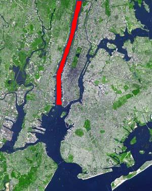
Chelsea is a neighborhood on the West Side of the borough of Manhattan in New York City. The area's boundaries are roughly 14th Street to the south, the Hudson River and West Street to the west, and Sixth Avenue to the east, with its northern boundary variously described as near the upper 20s or 34th Street, the next major crosstown street to the north. To the northwest of Chelsea is the neighborhood of Hell's Kitchen, as well as Hudson Yards; to the northeast are the Garment District and the remainder of Midtown South; to the east are NoMad and the Flatiron District; to the southwest is the Meatpacking District; and to the south and southeast are the West Village and the remainder of Greenwich Village. Chelsea is named after the Royal Hospital Chelsea in London, England.

<span class="mw-page-title-main">North River (Hudson River)</span> Section of the Hudson River between New York City and New Jersey

North River is an alternative name for the southernmost portion of the Hudson River in the vicinity of New York City and northeastern New Jersey in the United States.

RMS <i>Lusitania</i> British ocean liner that sank in 1915

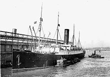
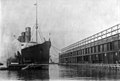
Lusitania was an ocean liner that was launched by the Cunard Line in 1906 and held the Blue Riband appellation for the fastest Atlantic crossing in 1908. It was briefly the world's largest passenger ship until the completion of the Mauretania three months later. She was sunk on her 202nd trans-Atlantic crossing, on 7 May 1915, by a German U-boat 11 miles (18 km) off the Old Head of Kinsale, Ireland, killing 1,199 passengers and crew.

RMS <i>Aquitania</i> British ocean liner (in service 1914–1950)

Aquitania was an ocean liner of the Cunard Line in service from 1914 to 1950. She was designed by Leonard Peskett and built by John Brown & Company in Clydebank, Scotland. She was launched on 21 April 1913 and sailed on her maiden voyage from Liverpool to New York on 30 May 1914. She was given the title of Royal Mail Ship (RMS) like many other Cunard ocean liners since she carried the royal mail on many of her voyages. Aquitania was the third in Cunard Line's grand trio of express liners, preceded by RMS Mauretania and RMS Lusitania, and was the last surviving four-funnelled ocean liner. Shortly after Aquitania entered service, World War I broke out, during which she was first converted into an auxiliary cruiser before being used as a troop transport and a hospital ship, notably as part of the Dardanelles Campaign.

RMS <i>Mauretania</i> (1906) Sister ship of Lusitania

Mauretania was an ocean liner designed by Leonard Peskett and built by Wigham Richardson and Swan Hunter on the River Tyne, England for the British Cunard Line, launched on the afternoon of 20 September 1906. She was the world's largest ship until the launch of RMS Olympic in 1910. Mauretania captured the eastbound Blue Riband on the maiden return voyage in December 1907, then claimed the westbound Blue Riband for the fastest transatlantic crossing during her 1909 season. She held both speed records for 20 years.

<span class="mw-page-title-main">West Side Highway</span> Boulevard in Manhattan, New York

The Joe DiMaggio Highway, commonly called the West Side Highway and formerly the Miller Highway, is a 5.42-mile-long (8.72 km) mostly surface section of New York State Route 9A (NY 9A), running from West 72nd Street along the Hudson River to the southern tip of Manhattan in New York City. It replaced the West Side Elevated Highway, built between 1929 and 1951, which was shut down in 1973 due to neglect and lack of maintenance, and was dismantled by 1989. North of 72nd Street the roadway continues north as the Henry Hudson Parkway.

<span class="mw-page-title-main">Port of Liverpool</span> Series of docks on the River Mersey, Liverpool, England

The Port of Liverpool is the enclosed 7.5-mile (12.1 km) dock system that runs from Brunswick Dock in Liverpool to Seaforth Dock, Seaforth, on the east side of the River Mersey and the Birkenhead Docks between Birkenhead and Wallasey on the west side of the river. The port was extended in 2016 by the building of an in-river container terminal at Seaforth Dock, named Liverpool2. The terminal can berth two 14,000 container Post-Panamax ships.

<span class="mw-page-title-main">Riverside South, Manhattan</span> Building complex in New York City

Riverside South is an urban development project in the Lincoln Square neighborhood of the Upper West Side of Manhattan, New York City. It was originated by six civic associations – The Municipal Art Society, Natural Resources Defense Council, New Yorkers for Parks, Regional Plan Association, Riverside Park Fund, and Westpride – in partnership with real estate developer Donald Trump. The largely residential complex, located on the site of a former New York Central Railroad yard, includes Freedom Place and Riverside Center. The $3 billion project is on 57 acres (23 ha) of land along the Hudson River between 59th Street and 72nd Street.

<span class="mw-page-title-main">Thirteenth Avenue (Manhattan)</span> Street in Manhattan, New York

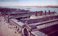
Thirteenth Avenue was a street in the New York City borough of Manhattan, New York City. It was built in 1837 along the Hudson River. The avenue was later removed in the early 20th century to make way for the Chelsea Piers.

<span class="mw-page-title-main">Pier 57</span> Pier in Manhattan, New York

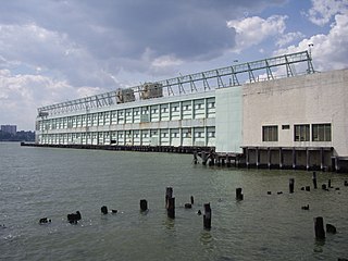
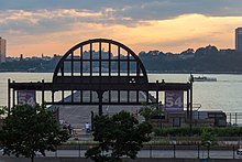
Pier 57 is a long pier located in the Hudson River on the West Side of Manhattan in New York City. Opened in December 1954, it sits at the end of West 15th Street on Eleventh Avenue, just south of the Chelsea Piers sports complex and just north of Little Island. It underwent renovations starting in the early 2010s, and is currently operated by Google. In addition to serving as a campus for employees, the pier opened to the public in April 2023.

<span class="mw-page-title-main">Arthur Rostron</span> British merchant seaman (1869–1940)

Sir Arthur Henry Rostron, KBE, RD, RNR was a British merchant seaman and a seagoing officer for the Cunard Line. He is best known as the captain of the ocean liner RMS Carpathia, when it rescued the survivors from the RMS Titanic after the ship sank in 1912 in the middle of the North Atlantic Ocean.

Daniel Allen Butler is an American author and playwright, who writes on historical topics, particularly maritime history. The Washington Times described him as a "steamship nut".

<span class="mw-page-title-main">Hudson River Park</span> Public park in Manhattan, New York

Hudson River Park is a waterfront park on the North River that extends from 59th Street south to Battery Park in the New York City borough of Manhattan. The park, a component of the Manhattan Waterfront Greenway, stretches 4.5 miles (7.2 km) and comprises 550 acres (220 ha), making it the second-largest park in Manhattan after the 843-acre (341 ha) Central Park.

<span class="mw-page-title-main">Manhattan Cruise Terminal</span> Ship terminal in Manhattan, New York

The Manhattan Cruise Terminal, formerly known as the New York Passenger Ship Terminal or Port Authority Passenger Ship Terminal is a ship terminal for ocean-going passenger ships in Hell's Kitchen, Manhattan, New York City. It was constructed and expanded in the 1920s and 1930s as a replacement for the Chelsea Piers.

RMS <i>Carpathia</i> Ocean liner known for rescuing survivors of RMS Titanic

RMS Carpathia was a Cunard Line transatlantic passenger steamship built by Swan Hunter & Wigham Richardson in their shipyard in Wallsend, England.

RMS <i>Saxonia</i> (1899)

The first RMS Saxonia was a passenger ship of the British Cunard Line. Between 1900 and 1925, Saxonia operated on North Atlantic and Mediterranean passenger routes, and she saw military service during World War I (1914–1918).

<span class="mw-page-title-main">Pier 40</span> Pier in Manhattan, New York

Pier 40 is a parking garage, sports facility, and former marine terminal at the west end of Houston Street in Manhattan, New York, within Hudson River Park. It is home to the New York Knights of the USA Rugby League, though it is primarily used by youth and high school athletics.

<span class="mw-page-title-main">Titanic International Society</span> Historical society dedicated to Titanic

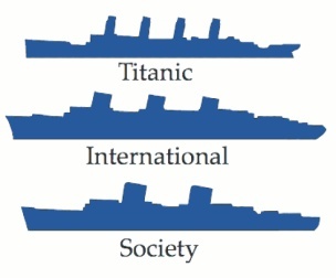
The Titanic International Society is an American 501(c)(3) non-profit organization dedicated to preserving the history of the Titanic and the events surrounding its sinking on April 15, 1912, when more than 1,500 people died. The society holds biennial conventions and occasional special events, such as memorial ceremonies at sites associated with the Titanic and a tribute to Titanic writer Walter Lord in his Baltimore hometown. It is one of several organizations worldwide dedicated to the memory of the Titanic.

<span class="mw-page-title-main">Little Island at Pier 55</span> Park in Manhattan, New York

Little Island at Pier 55 is an artificial island park in the Hudson River west of Manhattan in New York City, adjoining Hudson River Park. Designed by Heatherwick Studio, it is near the intersection of West Street and West 13th Street in the Meatpacking District and Chelsea neighborhoods of Manhattan. It is located slightly west of the Manhattan shoreline atop Hudson River Pier 55, connected to Hudson River Park in Manhattan by footbridges at 13th and 14th Streets. Little Island has three concession stands, a small stage, and a 687-seat amphitheater.

<span class="mw-page-title-main">Chelsea Waterside Park</span> Public park in Manhattan, New York

Chelsea Waterside Park, formerly Thomas F. Smith Park, is a public park located at West 23rd Street between 11th and 12th Avenues along the West Side Highway in Chelsea, Manhattan, New York City. It was originally operated by the government of New York City under the New York City Department of Parks and Recreation. As of 2023 it is part of the Chelsea section of Hudson River Park and managed by the Hudson River Park Trust.

References

  1. 1 2 "Chelsea Piers History 101 | Chelsea Piers NYC". www.chelseapiers.com. Retrieved August 1, 2019.
  2. 1 2 "GLTS - New York City Memorials". glts.org. Retrieved June 24, 2015.
  3. Bayor, Ronald H.; Meagher, Timothy (September 30, 1997). The New York Irish. JHU Press. ISBN   9780801857645 . Retrieved June 24, 2015.
  4. "Demonstration at Chelsea Pier, New York as Archbishop Mannix sailed on S.S. Baltin, 31 July 1920 [pi... - National Library of Australia". nla.gov.au. Retrieved June 24, 2015.
  5. "Chelsea Piers, NYC - AsNotedIn".
  6. Weber, Bruce (August 9, 1995). "For Huge Recreation Complex, It's Time to Start Playing All". The New York Times. ISSN   0362-4331 . Retrieved November 2, 2019.
  7. Cimino, Eric (Summer 2019). "Walking Titanic's Charity Trail in New York City: Part Two, The Meatpacking District and West Village". Voyage: Journal of the Titanic International Society. 108: 163–165, 167.
  8. Foderaro, Lisa W. (April 3, 2015). "How Diller and von Furstenberg Got Their Island in Hudson River Park". The New York Times . Retrieved May 12, 2015.
  9. Kilgannon, Corey (December 7, 2018). "What's That Strange New Thing Rising in the Hudson River?". The New York Times. Retrieved December 9, 2018.
  10. West, Melanie G. (November 17, 2014). "Hudson River Park Gets $100 Million Launch". The Wall Street Journal. Retrieved November 17, 2014.
  11. Del Signore, John (November 17, 2014). "Here's The Spectacular $165 Million Park Planned For The Hudson River". Gothamist. Archived from the original on November 20, 2014. Retrieved November 17, 2014.
  12. Slattery, Denis (September 14, 2017). "Plans scrapped for $200M 'Diller Island' floating on Hudson". NY Daily News. Retrieved September 14, 2017.
  13. Bagli, Charles V. (September 13, 2017). "Billionaire Diller's Plan for Elaborate Pier in the Hudson is Dead". The New York Times. ISSN   0362-4331 . Retrieved September 14, 2017.
  14. Bagli, Charles V. (October 25, 2017). "'Diller Island' Is Back From the Dead". The New York Times. ISSN   0362-4331 . Retrieved October 26, 2017.
  15. Warerkar, Tanay (April 18, 2018). "Work resumes on Pier 55's Thomas Heatherwick-designed park". Curbed NY. Retrieved December 9, 2018.
  16. Hilburg, Jonathan (April 24, 2018). "Construction at Heatherwick's Pier 55 is back on". Archpaper.com. Retrieved December 9, 2018.
  17. Young, Michael (January 30, 2021). "Thomas Heatherwick's Little Island Prepares for Spring Opening at Pier 55 in Chelsea, Manhattan". New York YIMBY.
  18. Andreeva, Nellie (June 25, 2010). "'Law & Order: SVU' Leaves New Jersey Over Nixed Tax Credit & May Move Into 'L&O' Set". Deadline Hollywood . Mail.com Media . Retrieved June 25, 2010.
  19. "Commissioner Oliver presents Law & Order Way". New York City Mayor's Office of Film Theatre & Broadcasting. September 16, 2004. Archived from the original on October 24, 2004. Retrieved August 1, 2019.

40°44′50″N74°0′35″W / 40.74722°N 74.00972°W / 40.74722; -74.00972