For thousands of years the Chippewa River was a water highway through a wilderness of forests and swamps, travelled by Ojibwe people, Lakota and others.[8] More recently, Native Americans guided European explorers up the river and around the Falls. Pierre LeSueur "discovered" the Chippewa Spring in 1700 when this area was part of New France.[9]Jonathan Carver traveled up the river with his party in 1768 when the area was claimed by Britain.[10]:31
White settlement of the Chippewa Falls area began in 1838, when Lyman Warren and his mostly-Chippewa wife started a farm and blacksmith shop five miles above the Falls. As agreed at the 1825 treaty of Prairie du Chien, Warren was to act as a sub-agent for the U.S. government to the Chippewas. Intertwined with that, Warren's farm served as a trading post for the American Fur Company.[10]:75[11]
The Chippewa River's watershed held a huge amount of valuable timber - more than the Wisconsin River,[12] and before railroad and roads, the only way to transport much of it out was down the river, through what would become Chippewa Falls. When the 1837 Treaty of St. Peters opened this part of northern Wisconsin to logging, Jean Brunett led a team up the Chippewa River to build a sawmill at the Falls. With great effort and expense, they managed to build the first mill there. It survived until June 1846, when a storm flooded the river and destroyed most of the millworks. The mill was rebuilt quickly and sawing resumed.[10]:76–77
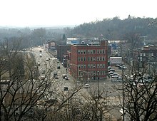
A settlement grew around the sawmill at the Falls, and in 1854 Chippewa Falls was chosen to be the seat of Chippewa County. A school, a post office, a mercantile store, the first churches, and the first newspaper had all opened by 1857. The city incorporated in 1869 with about 2,500 people. In the 1870s boardwalks were added along Bridge Street, gas streetlights were installed, and a telephone line was run up from Eau Claire.[13]:41–42
Railroads also arrived in the 1870s. In 1870, the West Wisconsin Railway had built a line from St. Paul, Minnesota, to Milwaukee, running ten miles to the south through Eau Claire. In 1875 the Eau Claire and Chippewa Falls Railway connected that line from Eau Claire to Chippewa Falls. In 1880, the CF&W was joined by the Wisconsin and Minnesota Railway pushing its way west from Abbotsford. This was followed in 1881 by the Chippewa Falls & Northern Railroad, which built a line north from Chippewa Falls to Bloomer, eventually extending it to Superior.
Lumbering continued to grow. By the 1880s the Chippewa valley held the best stand of white pine left in the Midwest. The sawmill at Chippewa Falls was run by the Chippewa Lumber and Boom Company, and the company's logging crews cut trees on their lands upstream in winter and drove logs down to the sawmill at the Falls each spring. The company employed 400 people and the mill at Chippewa was said to be "the largest sawmill under one roof in the world."[13]
The original Spring House.
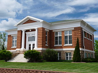
The Chippewa Spring gained renewed attention in 1887 when politician Thaddeus C. Pound founded the Chippewa Springs Health Club, and at one point oversaw the company that bottled the spring water for sale. A Spring House was built over the original spring in 1893. It remains today, across from the modern water bottling plant on Park Ave.[9]
Other industries started in the 1880s and 1890s: flour mills, a brewery, a woolen mill, cigar factories, a shoe factory, and a broom factory. By 1902 it had become clear that the pineries were not as inexhaustible as many had thought, and a group of business leaders began to promote more diverse industries. They succeeded in starting more shoe factories, a sugar beet factory, and a glove factory. The big sawmill closed in 1911, but the other industries kept the community going. By 1920 the city had fifty manufacturers who employed 3,000 workers.[13]:41–42
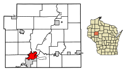
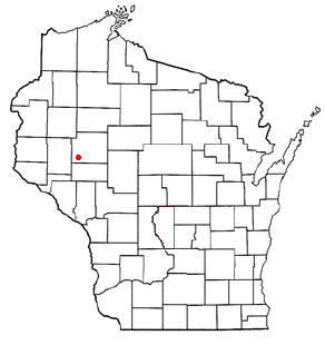
Geography
Chippewa Falls is located along the north bank of the Chippewa River approximately three miles west of Lake Wissota.[14]
According to the United States Census Bureau, the city has a total area of 11.86 square miles (30.7km2), of which 11.32 square miles (29.3km2) is land and 0.54 square miles (1.4km2) is water.[15]
As of the census of 2020,[4] the population was 14,731. The population density was 1,301.7 inhabitants per square mile (502.6/km2). There were 6,772 housing units at an average density of 598.4 per square mile (231.0/km2). The racial makeup of the city was 90.1% White, 1.9% Black or African American, 1.3% Asian, 0.7% Native American, 0.7% from other races, and 5.2% from two or more races. Ethnically, the population was 2.5% Hispanic or Latino of any race.
2010 census
As of the census[17] of 2010, there were 13,661 people, 5,896 households, and 3,275 families living in the city. The population density was 1,201.5 inhabitants per square mile (463.9/km2). There were 6,304 housing units at an average density of 554.4 per square mile (214.1/km2). The racial makeup of the city was 95.1% White, 1.7% African American, 0.7% Native American, 0.9% Asian, 0.2% from other races, and 1.4% from two or more races. Hispanic or Latino of any race were 1.6% of the population.
There were 5,896 households, of which 29.1% had children under the age of 18 living with them, 37.7% were married couples living together, 13.0% had a female householder with no husband present, 4.9% had a male householder with no wife present, and 44.5% were non-families. 37.6% of all households were made up of individuals, and 16.7% had someone living alone who was 65 years of age or older. The average household size was 2.18 and the average family size was 2.86.
The median age in the city was 38 years. 22.9% of residents were under the age of 18; 9.1% were between the ages of 18 and 24; 27.1% were from 25 to 44; 24.6% were from 45 to 64; and 16.4% were 65 years of age or older. The gender makeup of the city was 50.7% male and 49.3% female.
2000 census
At the 2000 census,[5] there were 12,925 people, 5,638 households and 3,247 families living in the city. The population density was 1,191.2 per square mile (459.9/km2). There were 5,905 housing units at an average density of 544.2 per square mile (210.1/km2). The racial makeup of the city was 97.62% White, 0.30% African American, 0.46% Native American, 0.67% Asian, 0.01% Pacific Islander, 0.16% from other races, and 0.77% from two or more races. Hispanic or Latino of any race were 0.63% of the population.
There were 5,638 households, of which 28.8% had children under the age of 18 living with them, 42.4% were married couples living together, 11.3% had a female householder with no husband present, and 42.4% were non-families. 36.5% of all households were made up of individuals, and 16.4% had someone living alone who was 65 years of age or older. The average household size was 2.20 and the average family size was 2.89.
Age distribution was 24.2% under the age of 18, 9.4% from 18 to 24, 28.2% from 25 to 44, 20.3% from 45 to 64, and 17.9% who were 65 years of age or older. The median age was 37 years. For every 100 females, there were 89.5 males. For every 100 females age 18 and over, there were 85.2 males.
The median household income was $32,744, and the median family income was $43,519. Males had a median income of $32,016 versus $22,655 for females. The per capita income for the city was $18,366. About 8.7% of families and 10.3% of the population were below the poverty line, including 15.5% of those under age 18 and 5.8% of those age 65 or over.
Economy
Renovated Chippewa Shoe Factory facing the Chippewa River in Chippewa Falls
As of 2011, the largest employers in the city were:[18]
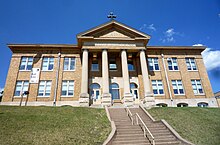
The original McDonell High School is now a public arts center.
The Chippewa Falls Area School District (CFSD) serves the city of Chippewa Falls. It has two high schools: Chippewa Falls Senior High and Chippewa Falls Alternate High School; two middle schools: Chippewa Falls Middle School, and Chippewa Falls Alternate Middle School; and six elementary schools: Parkview, Hillcrest, Southview, Stillson, Halmstad, and Jim Falls Elementary.
In addition there are several parochial schools: McDonell Central Catholic High School, Notre Dame Middle School, Holy Ghost, St. Charles, and St. Peter Elementary Schools, all of which are part of the McDonell Area Catholic Schools (MACS).
The original McDonell High School building, constructed at a prominent location above downtown Chippewa Falls, is listed on the State and National Register of Historic Places. The structure was built in 1907. After the high school was relocated to a new building in a more suburban location, this structure was vacant for several years. It was taken over by the Chippewa Valley Cultural Association and converted into the Heyde Center for the Arts in 2000.
Rusk County is a county in the U.S. state of Wisconsin. As of the 2020 census, the population was 14,188. Its county seat is Ladysmith. The Chippewa and Flambeau rivers and their tributaries flow through the county. The land ranges from corn/soybean farms and dairy farms to lakes rimmed with vacation homes to hiking trails through the Blue Hills.
Eau Claire County is a county located in the U.S. state of Wisconsin. As of the 2020 census, the population was 105,710. Its county seat is Eau Claire. The county took its name from the Eau Claire River.
Dunn County is a county in the U.S. state of Wisconsin. As of the 2020 census, the population was 45,440. Its county seat is Menomonie. Dunn County comprises the Menomonie Micropolitan Statistical Area and is included in the Eau Claire-Menomonie, WI Combined Statistical Area.
Chippewa County is a county located in the U.S. state of Wisconsin. It is named for the historic Chippewa people, also known as the Ojibwe, who long controlled this territory. As of the 2020 census, the population was 66,297. Its county seat is Chippewa Falls. The county was founded in 1845 from Crawford County, then in the Wisconsin Territory, and organized in 1853.
Cornell is a city in Chippewa County, Wisconsin, United States. The population was 1,467 at the 2010 census. It is located on the Chippewa River, upstream from Lake Wissota and Chippewa Falls, where Highway 64 crosses the river and Highway 27.
Eagle Point is a town in Chippewa County in the U.S. state of Wisconsin. The population was 3,053 at the 2010 census. The unincorporated communities of Eagle Point and Eagleton are located in the town.
Lake Holcombe is a town in Chippewa County in the U.S. state of Wisconsin. Its population was 1,031 at the 2010 census. The census-designated place of Holcombe is located in the town.
Stanley is a city in Chippewa and Clark counties in the U.S. state of Wisconsin. The population was 3,608 at the 2010 census. Of this, 3,602 were in Chippewa County, and 6 in Clark County.
The Town of Wheaton is located in Chippewa County in the U.S. state of Wisconsin. The population was 2,701 at the 2010 census, up from 2,366 at the 2000 census. The unincorporated communities of Old Albertville and Pine Grove are located in the town.
Owen is a city in Clark County in the U.S. state of Wisconsin. The population was 940 at the 2010 census. Owen is located directly east of the village of Withee, which is about half the size of Owen.
Altoona is a city in Eau Claire County, Wisconsin, United States. The population was 8,292 at the 2020 census with an estimated population in 2022 of 9,149. The city is a railroad terminal on the Union Pacific Railroad.
Eau Claire is a city in Eau Claire and Chippewa counties in the U.S. state of Wisconsin. It is the county seat of Eau Claire County. It had a population of 69,421 in 2020, making it the state's eighth-most populous city. It is the principal city of the Eau Claire metropolitan area, locally known as the Chippewa Valley, and is also part of the larger Eau Claire-Menomonie combined statistical area.
Rice Lake is a city in Barron County in northwest Wisconsin, United States, on the shore of the lake with the same name. The city is a commercial and tourist center for the surrounding rural areas. As of the 2020 census, the city had a total population of 9,040. The city is located mostly within the Town of Rice Lake.
Thorp is a city in Clark County in the U.S. state of Wisconsin. The population was 1,621 at the 2010 census. The city is located partially within the Town of Thorp and partially within the Town of Withee.
Menomonie is a city in and the county seat of Dunn County in the western part of the U.S. state of Wisconsin. The city's population was 16,843 as of the 2020 census.
Oconto Falls is a city in Oconto County, Wisconsin, United States. The population was 2,957 at the 2020 census. It is part of the Green Bay Metropolitan Statistical Area.
River Falls is a city in Pierce and St. Croix counties in the U.S. state of Wisconsin. It is located mostly within the town of River Falls, and adjacent to the town of Kinnickinnic in St. Croix County. River Falls is the most populous city in Pierce County. The population was 16,182 at the 2020 census, with 12,546 residing in Pierce County and 3,636 in St. Croix County. It is part of the Minneapolis-St. Paul metropolitan area and located approximately 30 miles (48 km) east of the center of that region.
Hudson is a city and county seat of St. Croix County, Wisconsin, United States. As of the 2020 United States census, its population was 14,755. It is part of the Minneapolis–St. Paul Metropolitan Statistical Area (MSA). The village of North Hudson is directly north of Hudson.
Lake Hallie is a village in Chippewa County, Wisconsin, United States. It was incorporated from part of the Town of Hallie on February 18, 2003. The 2010 census put the village's population at 6,448.
Black River Falls is a city in and the county seat of Jackson County, Wisconsin, United States. The population was 3,523 at the 2020 census. It is home to the administrative center of the Ho-Chunk Nation.
This page is based on this Wikipedia article Text is available under the CC BY-SA 4.0 license; additional terms may apply. Images, videos and audio are available under their respective licenses.

 The Cook-Rutledge House is on the National Register of Historic Places.
 Hotel Chippewa is on the National Register of Historic Places.
 Municipal Building
 Spring Street Bridge Chippewa Falls, WI
 Jacob Leinenkugel Brewing Company brewery.