Ashland, Wisconsin

Last updated

Ashland, Wisconsin
Ashland City Hall.JPG
Ashland City Hall was built in 1893 from locally quarried brownstone.
Ashland WI seal.png
Bayfield County Wisconsin Incorporated and Unincorporated areas Ashland Highlighted.svg
Location of Ashland in Ashland County
and Bayfield County, Wisconsin
USA Wisconsin relief location map.svg
Red pog.svg
Ashland
Usa edcp relief location map.png
Red pog.svg
Ashland
Coordinates: 46°35′24″N90°52′48″W / 46.59000°N 90.88000°W / 46.59000; -90.88000
CountryUnited States
State Wisconsin
Counties Ashland, Bayfield
Government
   Mayor Matthew McKenzie
   City Council
Members
  • Kevin Seefeldt
  • Sarah Jackson
  • Ana Tochterman
  • (Vacant)
  • Laura Graf
  • Charlie Ortman
  • Dick Pufall
Area
[1]
  Total13.60 sq mi (35.22 km2)
  Land13.35 sq mi (34.56 km2)
  Water0.26 sq mi (0.66 km2)
Elevation
671 ft (205 m)
Population
 (2020) [2]
  Total7,908
  Estimate 
(2021) [3]
7,918
  Density580/sq mi (220/km2)
Time zone UTC−6 (CST)
  Summer (DST) UTC−5 (CDT)
ZIP code
54806
Area codes 715 & 534
FIPS code 55-03225 [4]
GNIS feature ID1560982 [5]
Public Transit Bay Area Rural Transit
Website www.coawi.org
Ashland, Wisconsin Ashland welcome.jpg
Ashland, Wisconsin

Ashland is a city in Ashland and Bayfield counties in the U.S. state of Wisconsin. It is the county seat of Ashland County. The city is a port on Lake Superior, near the head of Chequamegon Bay. The population was 7,908 at the 2020 census, all of whom resided in the Ashland County portion of the city. The unpopulated Bayfield County portion is in the city's southwest, bordered by the easternmost part of the Town of Eileen.

Contents

The junction of US Highway 2 (US 2) and Wisconsin Highway 13 (WIS 13) is located at this city. It is the home of Northland College, Northwood Technical College, and the Sigurd Olson Environmental Institute.

History

Pre-settlement

Eight Native American nations have lived on Chequamegon Bay. Later settlers included European explorers, missionaries and fur traders, and more recently, Yankees from the eastern United States who platted and developed the lands, railroaders, shippers, loggers, entrepreneurs, and other settlers. Four flags have flown over the area around Ashland from colonial to contemporary times: Spanish, French, English and American.

The area was part of the United States' Northwest Territory. This region was divided into four successive territories for administration before becoming part of the state of Wisconsin: Indiana Territory, Michigan Territory, Illinois Territory, and Wisconsin Territory.

About the time Christopher Columbus arrived in the New World in the late 15th century, the Ojibwe people came to the land they called Sha-ga-waun-il-ong. This term has been translated numerous ways: "lowlands", the "needle", "the region of shallow water", and where "there are large extended breakers". Each is descriptive and suitably accurate. The Ojibwe stayed on Chequamegon Point for nearly a century before leaving. They settled first on Madeline Island and then moved to the Sault Ste. Marie region.

French fur traders Pierre d'Esprit, le Sieur Radisson and Medard Chouart, le Sieur des Groseillers were the first Europeans of record to visit Chequamegon Bay. They arrived in 1659 and built what has been called the first European dwelling place in what is now Wisconsin. A historical marker noting this is located at Maslowski Beach on US 2 on the west end of Ashland. The monument was erected in 1929 by the Old Settlers Club.

The Ojibwe heartily welcomed the Frenchmen. Five years later, Father Claude-Jean Allouez arrived. A Jesuit missionary, he brought the first word of Christianity to Wisconsin's shores. Allouez built a chapel not far from the stockade erected by Radisson and Groseillier; he worked and lived at the Bay until 1669.

Settlement

The massive Soo Line ore dock in 2007, before its demolition. AshlandOreDockWI-055-050507.jpg
The massive Soo Line ore dock in 2007, before its demolition.

In 1854, Ohioans Asaph Whittlesey and George Kilborn set out from La Pointe to explore the head of Chequamegon Bay. Whittlesey built a 10 ft (3.0 m) × 14 ft (4.3 m) cabin in Ashland. His wife, Lucy, and daughter, Eugenia, joined him in August and prepared to winter in their new home. Signs of settlement soon began to take place. The first community dance was held at their house. The Reverend L.H. Wheeler preached the first sermon on the first Independence Day that was observed there. This village was the location of the first post office and polling place for county offices. Sunday school was also conducted on the premises.

The Milwaukee, Lakeshore and Western Railroad platted the city in 1885, as railroad construction moved westward. Local landowner Martin Beaser named the settlement Ashland after Kentucky statesman Henry Clay’s residence. Previous names for the area included Bay City, Saint Mark (for Saint Mark's Basilica), and Whittlesey, the latter in honor of initial postmaster Adolph Whittlesey. [6]

In the nineteenth century, immigrants to the area included many individuals and families from Germany and northern Europe, as shown by the numerous Lutheran churches in town. Some were initially attracted to agriculture or jobs in the mining industry.

Tar and feather attacks during World War I

During the last year of World War I, from March–October 1918, six recorded incidents of vigilantism took place in the Ashland area, committed against men of German descent, who were suspected of pro-German sympathies.

In Ashland mobs of masked men abducted individuals at night from their homes, driving each to secluded areas where the men were tarred and feathered. A group identifying as the Knights of Liberty claimed responsibility for the attacks, saying in a letter to a local paper, "We have no purpose to do injustice to any man, but we do feel that any treasonable and seditious acts, or utterances, demand prompt punishment. These cases must not be allowed to run indefinitely, without anything being done. We want action and we want it now." [7]

Victims included:

Governor Emanuel Philipp expressed his indignation over these incidents, as well as reports of local ethnic Germans receiving threatening letters. He directed state Attorney General Spencer Haven to launch an inquiry. His investigator found the local citizenry uncooperative, including John C. Chapple, editor of the Ashland Daily Press and campaign manager for Roy P. Wilcox, a Republican candidate for governor proclaiming his own patriotism. [21] The inquiry found the community generally satisfied with the treatment of the first victims. [22] Haven expressed frustration at the local court, which refused to adjourn to allow the securing of evidence, and at the district attorney, who dismissed the first two cases for lack of said evidence. Haven threatened to send a company of the state guard to maintain law and order in the area. [23] Ultimately no one was convicted for any of the attacks. Two months after the world war ended, newspapers reported that the local Knights of Liberty had disbanded. The Milwaukee Journal reported that more than 800 men in Ashland County belonged to the order. [24] [25]

Dates of note

Ore dock

The harbor of Ashland was dominated by the massive Wisconsin Central Railway (later Soo Line) ore dock, built in 1916 to load iron ore mined in the area into freighters bound for industrial ports in the Midwest, such as Ashtabula, Ohio, where steel was produced. [26] The last of what had once been many such docks, the concrete structure is 80 feet (24 m) high and 75 feet (23 m) wide. In 1925 the dock was extended to 1,800 feet (550 m); it was last used to ship ore in 1965. [27]

In 2007 the Wisconsin Trust for Historic Preservation named it one of the "10 most endangered historic buildings in Wisconsin", a list intended to stir preservation efforts. [27] The main concrete structure and trestle had slowly deteriorated since the early 1970s because of lack of maintenance and the effects of the environment. [28] A structural inspection completed in 2006 and 2007 concluded that the ore dock had become structurally unsafe and was an imminent safety hazard. On May 14, 2009, the Ashland Planning Commission granted Canadian National Railway approval for demolition of the dock. All material on the ore dock was removed, down to the concrete base. [29] This was completed in 2013.

The base of the ore dock remains. The city took ownership of it from Canadian National Railway in May 2014. It is working with a consultant group to design a redevelopment plan for the base of the dock. [30] [31]

Geography

Large amounts of snow can accumulate over the long, cold winters. Ashland Snow.JPG
Large amounts of snow can accumulate over the long, cold winters.

Ashland is located along the south shore of Chequamegon Bay. According to the United States Census Bureau, the city has a total area of 13.70 square miles (35.48 km2), of which 13.42 square miles (34.76 km2) is land and 0.28 square miles (0.73 km2) is water. [32]

Climate

Ashland has a humid continental climate (Koppen: Dfb) with four distinct seasons and notably cold winters. Due to the city's proximity to Lake Superior, it sometimes has lake effect snow storms, with high amounts of snow recorded.

Climate data for Ashland, Wisconsin (John F. Kennedy Memorial Airport), 1991–2020 normals, extremes 1893–present [33]
MonthJanFebMarAprMayJunJulAugSepOctNovDecYear
Record high °F (°C)58
(14)
62
(17)
84
(29)
91
(33)
96
(36)
99
(37)
107
(42)
103
(39)
100
(38)
94
(34)
78
(26)
60
(16)
107
(42)
Mean daily maximum °F (°C)22.3
(−5.4)
26.6
(−3.0)
37.8
(3.2)
50.6
(10.3)
64.4
(18.0)
73.4
(23.0)
78.9
(26.1)
77.1
(25.1)
69.0
(20.6)
55.4
(13.0)
40.1
(4.5)
27.6
(−2.4)
51.9
(11.1)
Daily mean °F (°C)14.0
(−10.0)
17.2
(−8.2)
27.9
(−2.3)
39.5
(4.2)
51.5
(10.8)
61.0
(16.1)
66.7
(19.3)
65.1
(18.4)
57.4
(14.1)
45.0
(7.2)
32.3
(0.2)
20.1
(−6.6)
41.5
(5.3)
Mean daily minimum °F (°C)5.8
(−14.6)
7.7
(−13.5)
17.9
(−7.8)
28.5
(−1.9)
38.6
(3.7)
48.5
(9.2)
54.5
(12.5)
53.2
(11.8)
45.8
(7.7)
34.7
(1.5)
24.5
(−4.2)
12.6
(−10.8)
31.0
(−0.6)
Record low °F (°C)−41
(−41)
−40
(−40)
−30
(−34)
−5
(−21)
16
(−9)
23
(−5)
32
(0)
29
(−2)
12
(−11)
0
(−18)
−16
(−27)
−32
(−36)
−41
(−41)
Average precipitation inches (mm)0.64
(16)
0.70
(18)
1.12
(28)
2.26
(57)
3.45
(88)
3.92
(100)
3.93
(100)
3.44
(87)
3.03
(77)
2.83
(72)
1.55
(39)
0.98
(25)
27.85
(707)
Average precipitation days (≥ 0.01 in)6.76.27.810.012.112.912.913.912.711.38.97.9123.3
Source: NOAA [34] [35]

Demographics

Historical population
CensusPop.Note
1890 9,956
1900 13,07431.3%
1910 11,594−11.3%
1920 11,334−2.2%
1930 10,622−6.3%
1940 11,1014.5%
1950 10,640−4.2%
1960 10,132−4.8%
1970 9,615−5.1%
1980 9,115−5.2%
1990 8,695−4.6%
2000 8,620−0.9%
2010 8,216−4.7%
2020 7,908−3.7%
2021 (est.)7,918 [3] 0.1%
U.S. Decennial Census [36]

2020 census

As of the census of 2020, [37] the population was 7,908. The population density was 591.7 inhabitants per square mile (228.5/km2). There were 3,860 housing units at an average density of 288.8 per square mile (111.5/km2). The racial makeup of the city was 80.5% White, 10.0% Native American, 1.0% Black or African American, 0.8% Asian, 0.1% Pacific Islander, 0.4% from other races, and 7.2% from two or more races. Ethnically, the population was 2.8% Hispanic or Latino of any race.

2010 census

As of the census [2] of 2010, there were 8,216 people, 3,516 households, and 1,942 families residing in the city. The population density was 612.2 inhabitants per square mile (236.4/km2). There were 3,864 housing units at an average density of 287.9 per square mile (111.2/km2). The racial makeup of the city was 87.0% White, 0.5% African American, 7.5% Native American, 0.5% Asian, 0.5% from other races, and 4.0% from two or more races. Hispanic or Latino of any race were 2.1% of the population.

There were 3,516 households, of which 26.6% had children under the age of 18 living with them, 37.7% were married couples living together, 12.6% had a female householder with no husband present, 4.9% had a male householder with no wife present, and 44.8% were non-families. 36.7% of all households were made up of individuals, and 14.4% had someone living alone who was 65 years of age or older. The average household size was 2.17 and the average family size was 2.81.

The median age in the city was 38.6 years. 21% of residents were under the age of 18; 13% were between the ages of 18 and 24; 23.1% were from 25 to 44; 26.7% were from 45 to 64; and 16.3% were 65 years of age or older. The gender makeup of the city was 48.2% male and 51.8% female.

2000 census

As of the census of 2000, there were 8,620 people, 3,513 households, and 2,027 families residing in the city. The population density was 643.3 people per square mile (248.4/km2). There were 3,777 housing units at an average density of 108.8 persons/km2 (281.9 persons/sq mi). The racial makeup of the city was 90.17% White, 0.32% African American, 6.30% Native American, 0.49% Asian, 0.06% Pacific Islander, 0.43% from other races, and 2.23% from two or more races. 1.37% of the population were Hispanic or Latino of any race.

There were 3,513 households, out of which 28.3% had children under the age of 18 living with them, 42.5% were married couples living together, 11.7% have a woman whose husband does not live with her, and 42.3% were non-families. 35.6% of all households were made up of individuals, and 16.3% had someone living alone who was 65 years of age or older. The average household size was 2.24 and the average family size was 2.91.

In the city, the population was spread out, with 22.2% under the age of 18, 15.4% from 18 to 24, 24.7% from 25 to 44, 20.1% from 45 to 64, and 17.6% who were 65 years of age or older. The median age was 36 years. For every 100 females, there were 91.2 males. For every 100 females age 18 and over, there were 84.8 males.

The median income for a household in the city was $30,853, and the median income for a family was $40,549. Males had a median income of $30,122 versus $20,926 for females. The per capita income for the city was $16,330. About 7.5% of families and 12.7% of the population were below the poverty line, including 9.9% of those under the age of 18 and 10.0% ages 65 or older.:)

Government

Ashland has a mayor-council form of government. The mayor is elected at-large. In 2014, Debra Lewis was the first woman elected as mayor. The city's 11 wards are each represented by an elected alderperson (or councilor), elected from single-member districts. [38] City council meetings are held on the second and last Tuesday of the month. [38] Meetings are open to the public, although on occasion the Council may meet in closed session. One of the recent members, Wahsayah Whitebird, was one of only two members of the Communist Party USA in elected office during his tenure. [39]

Ashland City Hall is housed in the city's first post office, built by the federal government in 1893. It is listed on the National Register of Historic Places as the "Old Ashland Post Office". The County Courthouse is also located in the city.

In the Wisconsin State Legislature, Ashland is located in the 74th Assembly District, and the 25th Senate District, represented by Assembly Representative Beth Meyers and State Senator Janet Bewley.

In the United States House of Representatives, Ashland is part of Wisconsin's 7th congressional district. The seat is currently held by Tom Tiffany ®.

Presidential elections results
Presidential elections results [40]
Year Republican Democratic Third parties
2020 35.7% 1,51862.5%2,6601.8% 75
2016 34.5% 1,38858.3%2,3487.2% 289
2012 30.5% 1,24067.5%2,7411.9% 78
2008 27.3% 1,17771.3%3,0711.4% 61
2004 33.9% 1,56765.1%3,0071.0% 45
2000 34.0% 1,39958.2%2,3917.8% 319

Economy

A few of the largest manufacturers in the community include:

Many small businesses also make up a large portion of the local economy. Tourism is an important part of the area's commerce. The summer season attracts tourists for activities on the Great Lakes.

Education

Wheeler Hall, the original and oldest building at Northland College, is listed on the National Register of Historic Places. Northland College Wheeler Hall.JPG
Wheeler Hall, the original and oldest building at Northland College, is listed on the National Register of Historic Places.

Public schools

Private schools

Colleges

Media

News media

Radio

Television

Stations serving Ashland come from the Duluth market:

Transportation

Ashland Marina, looking north across Chequamegon Bay toward Lake Superior, with the ore dock in the background DSCN4852 ashlandharbor e.jpg
Ashland Marina, looking north across Chequamegon Bay toward Lake Superior, with the ore dock in the background

The two major highways in the city are US 2 and WIS 13.

Railroads

The city is one of the northern termini in Wisconsin for the Canadian National Railway (CN), parent company of the former Wisconsin Central Ltd. It took over the former Soo Line tracks in 1987. [41] However, after flooding in 2016 caused substantial damage to bridges south of town, CN discontinued service to Ashland (trains now reach only as far north as Park Falls). [42]

While Ashland has not had passenger train service since 1971, both Union Depot and the Soo Line Depot survive and are listed on the National Register of Historic Places.

Airports

Airports certified for commercial carrier operations near Ashland:

Other public use airports near Ashland:

Public transit

Local transportation is provided by the non-profit Bay Area Rural Transit (BART) system, which has bus stops throughout the community. Headquartered in Ashland's Industrial Park, BART also provides transportation to and from other communities in the Chequamegon Bay region, including Washburn, and Bayfield.

Intercity bus service to the city is provided by Indian Trails. [43]

Northern Towns Transport is a regional car service and shuttle provider, connecting Ashland and the Chequamegon Bay area with downtown Minneapolis, Minnesota and Minneapolis-St. Paul International Airport; as well as the Twin Ports of Superior, Wisconsin / Duluth, Minnesota and Duluth International Airport.

Churches

Arts and culture

The region is served by the Chequamegon Bay Arts Council, a non-profit organization promoting the arts in northern Wisconsin.

The Ashland Chamber Music Society is a volunteer organization that provides a venue for local and regional musicians to perform chamber music in the Ashland area.

The Bay Area Film Society is a group of film enthusiasts who sponsor the screening of classic films.

The Chequamegon Symphony Orchestra (CSO) provides orchestral concerts to the residents of northern Wisconsin.

Recreation

Natural places in the vicinity include Lake Superior, the Whittlesey Creek National Wildlife Refuge, and the nearby Chequamegon-Nicolet National Forest.

Parks

The Band Shell, located at Memorial Park, is a common summertime venue for outdoor music. Band Shell.JPG
The Band Shell, located at Memorial Park, is a common summertime venue for outdoor music.

Hiking and biking trails

The Northern Great Lakes Visitor Center is located west of Ashland, along US 2. It houses a geographic and natural history museum, as well as a bookstore and archive office of the Wisconsin Historical Society. Northern Great Lakes Visitor Center Ashland Wisconsin.jpg
The Northern Great Lakes Visitor Center is located west of Ashland, along US 2. It houses a geographic and natural history museum, as well as a bookstore and archive office of the Wisconsin Historical Society.

Boating

Camping

Local attractions

The Soo Line Depot Ashland WI Depot.jpg
The Soo Line Depot

Events

Notable people

Related Research Articles

<span class="mw-page-title-main">Price County, Wisconsin</span> County in Wisconsin, United States

Price County is a county in the U.S. state of Wisconsin. As of the 2020 census, the population was 14,054. Its county seat is Phillips.

<span class="mw-page-title-main">Bayfield County, Wisconsin</span> County in Wisconsin, United States

Bayfield County is a county located in the U.S. state of Wisconsin. As of the 2020 census, its population is 16,220. Its county seat is Washburn. The county was created in 1845 and organized in 1850. The Red Cliff Band of Lake Superior Chippewa has a reservation in Bayfield County and is the county's largest employer.

<span class="mw-page-title-main">Ashland County, Wisconsin</span> County in Wisconsin, United States

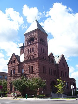
Ashland County is a county located in the U.S. state of Wisconsin. As of the 2020 census, the population was 16,027. Its county seat is Ashland. The county was formed on March 27, 1860, from La Pointe County. The county partly overlaps with the reservation of the Bad River Band of the Lake Superior Tribe of Chippewa Indians.

<span class="mw-page-title-main">Ironwood, Michigan</span> City in Michigan, United States

Ironwood is a city in Gogebic County in the Upper Peninsula of the U.S. state of Michigan, about 18 miles (29 km) south of Lake Superior. The city is on US Highway 2 across the Montreal River from Hurley, Wisconsin. It is the westernmost city in Michigan, situated on the same line of longitude as Clinton, Iowa and St. Louis, Missouri. The population was 5,045 at the 2020 census, down from 5,387 at the 2010 census. The city is bordered by Ironwood Township to the north, but the two are administered autonomously.

<span class="mw-page-title-main">La Pointe, Wisconsin</span> Unincorporated community in Wisconsin, United States

La Pointe is an unincorporated community in the town of La Pointe, Ashland County, Wisconsin, United States. It is on the western shore of Madeline Island, the largest of the Apostle Islands. Downtown La Pointe is adjacent to the Madeline Island Ferry dock. La Pointe has a post office with ZIP code 54850.

<span class="mw-page-title-main">Park Falls, Wisconsin</span> City in Wisconsin, United States

Park Falls is a city in Price County, Wisconsin, United States. The population was 2,462 at the 2010 census. Located in the woods of north central Wisconsin, primarily the Chequamegon National Forest, Park Falls is a small community divided by the North Fork of the Flambeau River, a popular destination for fishing, canoeing and whitewater rafting.

<span class="mw-page-title-main">Washburn, Wisconsin</span> City in Wisconsin, United States

Washburn is a city and the county seat of Bayfield County, in the U.S. state of Wisconsin. The population was 2,051 at the 2020 census. The city is just east of and adjacent to the Town of Washburn. It is in northern Wisconsin, on the shore of Lake Superior's Chequamegon Bay.

<span class="mw-page-title-main">Fond du Lac, Wisconsin</span> City in Wisconsin, United States

Fond du Lac is a city in and the county seat of Fond du Lac County, Wisconsin, United States. The population was 44,678 at the 2020 census. The city forms the core of the Fond du Lac metropolitan statistical area, which includes all of Fond du Lac County. Fond du Lac is the 348th-largest metropolitan area in the United States.

<span class="mw-page-title-main">Manitowoc, Wisconsin</span> City in Wisconsin, United States

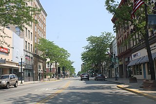
Manitowoc is a city in and the county seat of Manitowoc County, Wisconsin, United States. The city is located on Lake Michigan at the mouth of the Manitowoc River. According to the 2020 census, Manitowoc had a population of 34,626, with over 50,000 residents in the surrounding communities.

<span class="mw-page-title-main">Bad River Band of the Lake Superior Tribe of Chippewa Indians</span> Indian tribe in Wisconsin, United States

The Bad River LaPointe Band of the Lake Superior Tribe of Chippewa Indians or Bad River Tribe for short are a federally recognized tribe of Ojibwe people. The tribe had 6,945 members as of 2010. The Bad River Reservation is located on the south shore of Lake Superior and has a land area of about 193.11 square miles (500.15 km2) in northern Wisconsin, straddling Ashland and Iron counties. Odanah, the administrative and cultural center, is located five miles (8.0 km) east of the town of Ashland on U.S. Highway 2. The reservation population was 1,545 in 2020. Most of the reservation is managed as undeveloped forest and wetland, providing a habitat for wild rice and other natural resources.

<span class="mw-page-title-main">Chequamegon Point Light</span> Lighthouse

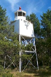
The Chequamegon Point Lighthouse is a lighthouse located on Long Island, one of the Apostle Islands, in Lake Superior in Ashland County, Wisconsin, near the city of Bayfield.

<span class="mw-page-title-main">Wisconsin Highway 13</span> Highway in Wisconsin

State Trunk Highway 13 is a state highway running north–south across northwest and central Wisconsin. WIS 13 serves as a major north–south route connecting the communities of Wisconsin Dells, Wisconsin Rapids, Marshfield and Ashland. WIS 13 is part of the Lake Superior Circle Tour from its northern/western terminus to Ashland at is eastern junction with U.S. Highway 2 (US 2). The road also provides access to the Apostle Islands National Lakeshore off the Lake Superior shoreline at Bayfield. The highway is two-lane surface road with the exception of various urban multilane road sections.

<span class="mw-page-title-main">U.S. Route 2 in Wisconsin</span> U.S. Highway in Wisconsin

US Highway 2 (US 2) is a part of the United States Numbered Highway System that runs from Everett, Washington, to St. Ignace, Michigan. In Wisconsin, the highway enters runs east–west across the northwestern part of the state and re-enters the state in the northeast part. It runs from the Richard I. Bong Memorial Bridge over the Saint Louis Bay at Superior, where it enters from Minnesota, east to the Michigan state line near Hurley. Further east, US 2 re-enters Wisconsin from Michigan in Florence County and briefly traverses that county before re-entering Michigan. US 2 is a Wisconsin Corridors 2020 Connecting route east of its concurrency with US 53. The section concurrent with US 53 is a Wisconsin Corridors 2020 Backbone route.

<span class="mw-page-title-main">Glidden, Wisconsin</span> Census-designated place in Wisconsin, United States

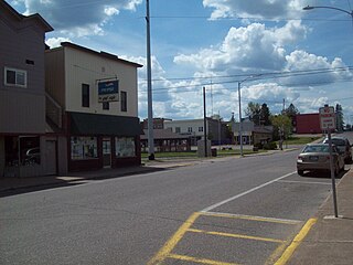
Glidden is an unincorporated census-designated place in the town of Jacobs in Ashland County, Wisconsin, United States. It is located on County Highway N near Wisconsin Highway 13. As of the 2010 census, its population was 507.

<span class="mw-page-title-main">La Pointe (town), Wisconsin</span> Town in Wisconsin, United States

La Pointe is a town in Ashland County in the U.S. state of Wisconsin. The population was 428 at the 2020 census. The town includes all of the Apostle Islands except for the westernmost four, which lie in the towns of Bayfield and Russell in Bayfield County. The town includes the unincorporated community of La Pointe on Madeline Island, the largest of the Apostle Islands. The communities of Middleport and Old Fort are also located in the town. Its name in the Anishinaabe language is Mooningwanekaaning, meaning "The Home of the Golden Breasted Woodpecker".

The 25th Senate District of Wisconsin is one of 33 districts in the Wisconsin Senate. Located in northwest Wisconsin, where Wisconsin meets Lake Superior, the district comprises all of Ashland, Bayfield, Burnett, Douglas, Iron, Polk, Sawyer, and Washburn counties. It contains the cities of Superior, Ashland, Bayfield, Hayward, Spooner, and Washburn. The district also includes the Bad River Indian reservation and the Chequamegon–Nicolet National Forest.

<span class="mw-page-title-main">Asaph Whittlesey</span> American politician

Asaph Whittlesey was the first Wisconsin state legislator from the Lake Superior region. In 1854, he settled the city of Ashland, Wisconsin.

<span class="mw-page-title-main">Lynching of Olli Kinkkonen</span> Finnish-American dockworker who was lynched in 1918

Olli (Olof) Kiukkonen Kinkkonen was a Finnish-American dockworker and logger. He was lynched in Duluth, Minnesota, by the Knights of Liberty on September 18, 1918, for renouncing his American citizenship because he wanted to avoid fighting in World War I.

<i>Robert C. Pringle</i> (tug) Wooden-hulled American tugboat that sank in Lake Michigan

Robert C. Pringle, originally named Chequamegon, was a wooden-hulled American tugboat that sank without loss of life on Lake Michigan, near Sheboygan, Wisconsin, on June 19, 1922, after striking an obstruction.

The Knights of Liberty was an American volunteer nationalist secret society and vigilance committee active circa 1917–1918, claiming responsibility for violence against perceived disloyalty during World War I. They are known for the 1917 Tulsa Outrage in Oklahoma, the 1918 lynching of Olli Kinkkonen in Minnesota, and a spree of 1918 tarring and feathering events in Wisconsin and California.

References

  1. "2019 U.S. Gazetteer Files". United States Census Bureau. Retrieved August 7, 2020.
  2. 1 2 "U.S. Census website". United States Census Bureau . Retrieved November 18, 2012.
  3. 1 2 "Population and Housing Unit Estimates". United States Census Bureau. July 1, 2021. Retrieved July 15, 2022.
  4. "U.S. Census website". United States Census Bureau . Retrieved January 31, 2008.
  5. "US Board on Geographic Names". United States Geological Survey. October 25, 2007. Retrieved January 31, 2008.
  6. Gard, Robert (2015). The Romance of Wisconsin Place Names (2nd ed.). Madison, WI: Wisconsin Historical Society Press. p. 13. ISBN   978-0-87020-707-5.
  7. "Investigating Feather Party". The Eau Claire Leader. April 26, 1918. p. 3. OCLC   12868418 . Retrieved March 1, 2023 via Newspapers.com.
  8. "Tar and Feather Ashland Teacher". The New North. Rhinelander, Wisconsin. April 4, 1918. p. 2. OCLC   12814148 . Retrieved March 1, 2023 via Newspapers.com.
  9. "Ashland Man is Punished by Crowd". The Capital Times. Madison, Wisconsin. April 11, 1918. p. 7. ISSN   0749-4068 . Retrieved March 1, 2023 via Newspapers.com.
  10. "Citizens Block Inquiry, Charge". The Wisconsin State Journal. April 27, 1918. ISSN   0749-405X . Retrieved March 1, 2023 via Newspapers.com.
  11. "Promises More Tar Bees at Ashland". The Capital Times. Madison, Wisconsin. July 18, 1918. p. 2. ISSN   0749-4068 . Retrieved March 1, 2023 via Newspapers.com. The case was given a preliminary hearing at Ashland on Tuesday and Wednesday, which resulted in the municipal judge dismissing the cases.
  12. "Tar and Feather Artists are Acquitted of Charge". The Eau Claire Leader. July 18, 1918. p. 2. OCLC   12868418 . Retrieved March 1, 2023 via Newspapers.com.
  13. "Happenings of the Week in Wisconsin". The Grand Rapids Tribune. July 25, 1918. p. 2. OCLC   12201633 . Retrieved March 1, 2023 via Newspapers.com.
  14. "Ashland Tells Philipp of 3rd Tar Bee". The Capital Times. Madison, Wisconsin. May 9, 1918. p. 1. ISSN   0749-4068 . Retrieved April 12, 2017 via Newspapers.com.
  15. "Another Tar and Feather Victim, Third at Ashland". The Manitowoc Daily Herald. May 9, 1918. p. 8. OCLC   14635173 . Retrieved March 1, 2023 via NewspaperArchive.com.
  16. "Secrecy Will Hamper Taking Bee Evidence". The Capital Times. Madison, Wisconsin. May 11, 1918. p. 1. ISSN   0749-4068 . Retrieved March 1, 2023 via Newspapers.com.
  17. "No Safety in Ashland for Landraint". The Capital Times. Madison, Wisconsin. June 13, 1918. p. 5. ISSN   0749-4068 . Retrieved April 12, 2017 via Newspapers.com.
  18. "Protection Asked from Mob Violence". The Capital Times. Madison, Wisconsin. Associate Press. June 3, 1918. p. 1. ISSN   0749-4068 . Retrieved March 1, 2023 via Newspapers.com.
  19. "Fourth Case of Tar Party near Ashland". The Capital Times. Madison, Wisconsin. July 3, 1918. p. 2. ISSN   0749-4068 . Retrieved March 1, 2023 via Newspapers.com.
  20. "Tar and Feather Man near Ashland". The Racine Journal-News. October 26, 1918. p. 7. OCLC   15476078 . Retrieved March 1, 2023 via Newspapers.com.
  21. Evjue, William T. (July 26, 1918). "Wisconsin Newspapers Must Share Blame for Lawlessness in Many Parts of the State". The Capital Times. Madison, Wisconsin. pp. 1, 6. ISSN   0749-4068 . Retrieved December 18, 2018 via Newspapers.com.
  22. "Finds Ashland Proud of Tarring". The Wisconsin State Journal. April 29, 1918. p. 6. ISSN   0749-405X . Retrieved March 1, 2023 via Newspapers.com.
  23. "Urges Martial Law for Ashland". The Wisconsin State Journal. May 10, 1918. p. 1. ISSN   0749-405X . Retrieved March 1, 2023 via Newspapers.com.
  24. "Liberty Knight Order Quits". The Marshfield Times. February 5, 1919. p. 3. OCLC   14163323 . Retrieved March 1, 2013 via NewspaperArchive.com.
  25. "Mysterious Liberty League at Ashland Has Now Disbanded". The Eau Claire Leader. January 24, 1919. p. 6. OCLC   12868418 . Retrieved March 1, 2023 via Newspapers.com.
  26. "10 Most Endangered Properties". Wisconsin Trust for Historic Preservation. Archived from the original on March 18, 2007. Retrieved May 7, 2007.
  27. 1 2 Ryan, Sean (May 27, 2005). "Wisconsin Trust for Historic Preservation names state's most endangered buildings". Daily Reporter. Retrieved May 30, 2009.
  28. Structural Condition Assessment Report (PDF).[ permanent dead link ]
  29. Dally, Chad (May 15, 2009). "So long, oredock ... demolition to begin this month". The Daily Press. Ashland, Wisconsin. Archived from the original on May 21, 2009. Retrieved May 30, 2009.
  30. Olivo, Rick (March 23, 2016). "Public views proposed ore dock redevelopment concepts". Ashland Daily Press. Retrieved May 6, 2016.
  31. City of Ashland, Wisconsin. "Ashland Oredock Project". City of Ashland, Wisconsin. Archived from the original on August 4, 2018.
  32. "US Gazetteer files 2010". United States Census Bureau. Archived from the original on January 25, 2012. Retrieved November 18, 2012.
  33. Records kept continuously at John F. Kennedy Memorial Airport since October 14, 1998, and at a farm co-op site around Ashland from March 1893 to October 13, 1998. See ThreadEx.
  34. "NowData – NOAA Online Weather Data". National Oceanic and Atmospheric Administration. Retrieved June 13, 2021.
  35. "Station: Ashland Kennedy Mem AP, WI". U.S. Climate Normals 2020: U.S. Monthly Climate Normals (1991–2020). National Oceanic and Atmospheric Administration. Retrieved June 13, 2021.
  36. "Census of Population and Housing". Census.gov. Retrieved June 4, 2015.
  37. "2020 Decennial Census: Ashland city, Wisconsin". data.census.gov. U.S. Census Bureau. Retrieved July 15, 2022.
  38. 1 2 City of Ashland, Wisconsin. "City Council". City of Ashland, Wisconsin. Archived from the original on June 12, 2009.
  39. Winger, Richard (May 7, 2019). "Communist Party Member Elected to City Council of Ashland, Wisconsin". Ballot Access News. Retrieved January 1, 2021.
  40. "Wisconsin election results". Lubar Center for Public Policy and Civic Education. Retrieved November 13, 2021.
  41. Bureau of Planning (February 2005). Wisconsin Railroads (PDF) (Map). Scale not given. Madison: Wisconsin Department of Transportation. Archived from the original (PDF) on June 25, 2008.
  42. Wisconsin Department of Transportation (June 2018). Wisconsin Northwoods Freight Rail Study (PDF). Wisconsin Department of Transportation. p. 20.
  43. "Indian Trails Schedule 1491" (PDF). Retrieved July 20, 2023.
  44. "Trinity Evangelical Lutheran Church".
  45. 1 2 3 4 5 6 7 8 "Attractions". Visit Ashland. Archived from the original on November 29, 2010.