
Skywarn is a program of the National Weather Service (NWS). Its mission is to collect reports of localized severe weather in the United States. These reports are used to aid forecasters in issuing and verifying severe weather watches and warnings and to improve the forecasting and warning processes and the tools used to collect meteorological data. Reports are also used by local emergency managers and public safety organizations.

A tornado warning is a public warning that is issued by weather forecasting agencies to an area in the direct path of a tornado or a thunderstorm that is capable of producing a tornado. Modern weather surveillance technology such as Doppler weather radar allow for early detection of rotation in a thunderstorm, and for subsequent warnings to be issued before a tornado actually develops. It is nevertheless still not uncommon that warnings are issued based on reported visual sighting of a tornado, funnel cloud, or wall cloud, typically from weather spotters or the public, but also law enforcement or local emergency management. In particular, a tornado can develop in a gap of radar coverage, of which there are several known in the United States.

A tornado watch is a severe weather watch product of the National Weather Service that is issued by national weather forecasting agencies when meteorological conditions are favorable for the development of severe thunderstorms capable of producing tornadoes. In addition to the potential for tornado development, thunderstorms that develop within the watch area may contain large hail, straight-line winds, intense rainfall and/or flooding that pose a similar damage risk as the attendant tornado threat. A tornado watch does not mean a tornado is active or will appear, just that favorable conditions increases the likelihood of such happening. A watch must not be confused with a tornado warning.

The National Weather Service (NWS) is an agency of the United States federal government that is tasked with providing weather forecasts, warnings of hazardous weather, and other weather-related products to organizations and the public for the purposes of protection, safety, and general information. It is a part of the National Oceanic and Atmospheric Administration (NOAA) branch of the Department of Commerce, and is headquartered in Silver Spring, Maryland, within the Washington metropolitan area. The agency was known as the United States Weather Bureau from 1890 until it adopted its current name in 1970.

Storm chasing is broadly defined as the deliberate pursuit of any severe weather phenomenon, regardless of motive, but most commonly for curiosity, adventure, scientific investigation, or for news or media coverage. A person who chases storms is known as a storm chaser or simply a chaser.

A gustnado is a brief, shallow surface-based vortex which forms within the downburst emanating from a thunderstorm. The name is a portmanteau by elision of "gust front tornado", as gustnadoes form due to non-tornadic straight-line wind features in the downdraft (outflow), specifically within the gust front of strong thunderstorms. Gustnadoes tend to be noticed when the vortices loft sufficient debris or form condensation cloud to be visible although it is the wind that makes the gustnado, similarly to tornadoes. As these eddies very rarely connect from the surface to the cloud base, they are very rarely considered as tornadoes. The gustnado has little in common with tornadoes structurally or dynamically in regard to vertical development, intensity, longevity, or formative process—as classic tornadoes are associated with mesocyclones within the inflow (updraft) of the storm, not the outflow.
The National Severe Storms Laboratory (NSSL) is a National Oceanic and Atmospheric Administration (NOAA) weather research laboratory under the Office of Oceanic and Atmospheric Research. It is one of seven NOAA Research Laboratories (RLs).
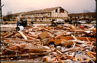
A destructive tornado outbreak struck a wide swath of the Southern and Eastern United States as well as Canada on November 15 and 16, 1989. It produced at least 40 tornadoes and caused 30 deaths as a result of two deadly tornadoes. The most devastating event was the Huntsville, Alabama F4 tornado, which killed 21 on the afternoon of November 15. Nine more fatalities occurred at a single elementary school by an F1 tornado on November 16 in Newburgh, New York, although further survey revealed that this might have been a downburst instead. This outbreak also produced the most tornadoes in a single day in New Jersey, later tied on April 1, 2023. Several other significant tornadoes were reported across 15 states.

This article describes severe weather terminology used by the National Weather Service (NWS) in the United States. The NWS, a government agency operating as an arm of the National Oceanic and Atmospheric Administration (NOAA) branch of the United States Department of Commerce (DoC), defines precise meanings for nearly all of its weather terms.
The Tornado and Storm Research Organisation (TORRO) was founded by Terence Meaden in 1974. Originally called the Tornado Research Organisation, it was expanded in 1982 following the inclusion of the Thunderstorm Census Organisation (TCO) after the death of its founder Morris Bower and his wife. The current Head of TORRO is Paul Knightley, a professional meteorologist.

StormReady is a community preparedness program in the United States that encourages government entities and commercial gathering sites to prepare for severe storms. The program, sponsored by the United States National Weather Service, issues recognition to communities and sites across the country that demonstrate severe weather readiness. The program is voluntary, and provides communities with clear-cut advice from a partnership with the local National Weather Service Office, state and local emergency managers, and the media. The program has been credited with saving the lives of more than 50 movie-goers in Van Wert County, Ohio in November 2002. As of June 1, 2011, there were 1,752 StormReady sites in 50 states.
A significant weather advisory was a hazardous weather statement issued by certain Weather Forecast Offices (WFO) of the National Weather Service (NWS) in the United States to alert the public of thunderstorm activity that is below designated severe criteria for and/or is not expected to produce severe weather. The title assigned to the advisory — alternately titled "significant weather alert" or referenced by its originating product, "special weather statement" — varied by the issuing WFO.
Convective storm detection is the meteorological observation, and short-term prediction, of deep moist convection (DMC). DMC describes atmospheric conditions producing single or clusters of large vertical extension clouds ranging from cumulus congestus to cumulonimbus, the latter producing thunderstorms associated with lightning and thunder. Those two types of clouds can produce severe weather at the surface and aloft.
The Community Collaborative Rain, Hail and Snow Network, or CoCoRaHS, is a network of volunteer weather observers in the United States, Canada, and the Bahamas that take daily readings of precipitation and report them to a central data store over the internet. The program is an example of citizen science.
Storm spotting is a form of weather spotting in which observers watch for the approach of severe weather, monitor its development and progression, and actively relay their findings to local authorities.

National Weather Service Lincoln, Illinois also known as National Weather Service Central Illinois is a weather forecast office responsible for monitoring weather conditions for 35 counties in Central and Southeastern Illinois. The Central Illinois office initially consisted of two forecast offices in Peoria and Springfield until the current location in Lincoln became the sole local forecast office in 1995. Federal meteorology offices and stations in the region date back to the 19th century when the Army Signal Service began taking weather observations using weather equipment at the Springer Building in Springfield. Since that time the presence of the National Weather Service greatly increased with the installation of new weather radars, stations and forecast offices. The current office in Lincoln maintains a WSR-88D (NEXRAD) radar system, and Advanced Weather Interactive Processing System (AWIPS) that greatly improve forecasting in the region. Lincoln is in charge of weather forecasts, warnings and local statements as well as aviation weather.
The Spotter Network (SN) is a system that utilizes storm spotter and chaser reports of location and severe weather in a centralized framework for use by coordinators such as emergency managers, Skywarn and related spotter organizations, and the National Weather Service. It uses GPS to provide accurate and automated position data of storm spotters and chasers for coordination and reporting, which in turn provides ground truth to public servants engaged in the protection of life and property. The network is a combination of locally installed software for position and status reporting and web-based processing, mapping, and reporting.
The following is a glossary of tornado terms. It includes scientific as well as selected informal terminology.
National Weather Service - Pleasant Hill/Kansas City, Missouri is a Weather Forecast Office (WFO) of the National Weather Service, which is responsible for forecasts and the dissemination of weather warnings and advisories for 37 counties in northern and western Missouri and seven counties in extreme eastern Kansas, including the Kansas City and St. Joseph metropolitan areas. Though, as the Storm Prediction Center (SPC) in Norman, Oklahoma is responsible for issuing severe thunderstorm and tornado watches, the Pleasant Hill/Kansas City WFO only composes outline and status updates for SPC-issued watches affecting any portion of its designated County Warning Area.

The NOAA Cooperative Observer Program (COOP) is a citizen weather observer network run by the U.S. National Weather Service (NWS) and National Centers for Environmental Information (NCEI). Over 8,700 volunteers from the fifty states and all territories report at least daily a variety of weather conditions such as daily maximum and minimum temperatures, 24-hour precipitation totals, including snowfall, and significant weather occurrences throughout a day that are recorded via remarks in observer logs. Some stations also report stream stage or tidal levels.