
Clarke County is a county located in the southwestern part of the U.S. state of Alabama. As of the 2020 census, the population was 23,087. The county seat is Grove Hill. The county's largest city is Jackson. The county was created by the legislature of the Mississippi Territory in 1812. It is named in honor of General John Clarke of Georgia, who was later elected governor of that state.

Washington County is a county located in the southwestern part of the U.S. state of Alabama. As of the 2020 census, the population was 15,388. The county seat is Chatom. The county was named in honor of George Washington, the first President of the United States. In September 2018 The United States Office of Management and Budget (OMB) added Washington County to the Mobile, Alabama Metropolitan Statistical Area but was removed in effective July 2023.
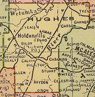
Hughes County is a county located in south central U.S. state of Oklahoma. As of the 2020 census, the population was 13,367. Its county seat is Holdenville. The county was named for W. C. Hughes, an Oklahoma City lawyer who was a member of the Oklahoma Constitutional Convention.

Grady County is a county located in the U.S. state of Oklahoma. As of the 2020 census, the population was 54,795. Its county seat is Chickasha. It was named for Henry W. Grady, an editor of the Atlanta Constitution and southern orator.

Little River County is a county located on the southwest border of the U.S. state of Arkansas, bordering a corner with Texas and Oklahoma. As of the 2020 census, the population was 12,026. The county seat is Ashdown.
Grove Hill is a town in Clarke County, Alabama, United States. At the 2020 census, the population was 1,818. It is the county seat of Clarke County and home of the Clarke County Museum.

Thomasville is a city in Clarke County, Alabama, United States. At the 2020 census, the population was 3,649. Founded as a late 19th-century railroad town, it has transitioned over the course of more than a century into a 21st-century commercial hub. It is the childhood hometown of author and storyteller Kathryn Tucker Windham.

Amite City is a town in and the seat of Tangipahoa Parish in southeastern Louisiana, United States. The population was 4,141 at the 2010 census. It is part of the Hammond Micropolitan Statistical Area.

Ponchatoula is the second-largest city in Tangipahoa Parish, Louisiana. The population was 6,559 at the 2010 census and 7,545 at the time of the 2020 population estimates program.

Shubuta is a town in Clarke County, Mississippi, United States, which is located on the eastern border of the state. The population was 441 as of the 2010 census, down from 651 at the 2000 census. Developed around an early 19th-century trading post on the Chickasawhay River, it was built near a Choctaw town. Shubuta is a Choctaw word meaning "smokey water".

Wister is a town in Le Flore County, Oklahoma, United States. It is part of the Fort Smith metropolitan area. The population was 1,102 at the 2010 census. Wister is named for Gutman G. Wister, an official with the Choctaw, Oklahoma and Gulf Railroad.

Nash is a city in Bowie County, Texas, United States, and a suburb of Texarkana. It is part of the Texarkana metropolitan area. The population was 2,960 at the 2010 census, up from 2,169 at the 2000 census. In 2020, its population was 3,814, representing continued population growth as a suburban community.
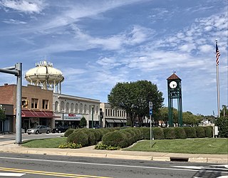
Thomasville is a city in Davidson County, North Carolina, United States. The population was 27,183 at the 2020 census. The city was once notable for its furniture industry, as were its neighbors High Point and Lexington. This Piedmont Triad community was established in 1852 and hosts the state's oldest festival, "Everybody's Day".

Jordan Township is one of twelve townships in Warren County, Indiana, United States. According to the 2020 census, its population was 220 and it contained 96 housing units. It is almost entirely agricultural and contains no incorporated towns.

Gainestown is an unincorporated community on the Alabama River in Clarke County, Alabama, United States. It was named for George Strother Gaines, who was the senior United States Indian agent in the region; he established a trading post here in 1809 for business with the Choctaw, the predominant tribe.
Gosport is an unincorporated community in Clarke County, Alabama, United States. Gosport is also close to the unincorporated town of Whatley, the two are usually confused with one another, and sometimes thought as the same place.

Suggsville is an unincorporated community in Clarke County, Alabama.
The Choctaw Corner is a former Native American boundary location near the modern border between Clarke and Marengo counties in Alabama, United States. It was established as the northernmost terminus for a mutually agreed upon boundary line between the Choctaw and Creek peoples during the Mississippi Territory period. This boundary line, now known as the “Old Indian Treaty Boundary,” starts at the Alabama River cut-off in southernmost Clarke County and follows a northward path through the county along the drainage divide between the Tombigbee and Alabama rivers to the Choctaw Corner, then turns ninety degrees to the west and follows the modern county-line between Clarke and Marengo to the Tombigbee River.
Petros is an unincorporated community in Le Flore County, Oklahoma, United States. It is located approximately two miles south of Heavener, Oklahoma and one mile north of the Poteau River.
Stapp is an unincorporated community in Le Flore County, Oklahoma, United States. It is located approximately eight miles south of Heavener on US Route 59.

