Churchdown

Last updated

Churchdown
Old School House Churchdown UK.JPG
The Old School House building at The Green in Churchdown
Gloucestershire UK location map.svg
Red pog.svg
Churchdown
Location within Gloucestershire
Population10,990 (2011)
OS grid reference ST779869
District
Shire county
Region
Country England
Sovereign state United Kingdom
Post town GLOUCESTER
Postcode district GL3
Dialling code 01452
Police Gloucestershire
Fire Gloucestershire
Ambulance South Western
UK Parliament
List of places
UK
England
Gloucestershire
51°53′N2°10′W / 51.88°N 02.17°W / 51.88; -02.17

Churchdown is a large village in Gloucestershire, England, situated between Gloucester and Cheltenham in the south of the Tewkesbury Borough.

Contents

The village has two centres. The older (Brookfield or "village") centre is in Church Road near St Andrew's Church; the more modern centre is in St John's Avenue near St John's Church. [1] Churchdown is a relatively large village, with a population of 11,261 (2001), [2] reducing to 10,990 at the 2011 census. [3] The village has a size of approximately 16.5 km2 (exactly 4,076 acres). Accordingly, the population density is 666 persons/km2. [4]

Location

Churchdown is located in a semi-rural environment; so close to Gloucester and Cheltenham, but surrounded on three sides by open countryside. Churchdown borders Imjin Barracks and the district of Innsworth to the North West.

Churchdown Hill

A local landmark is Churchdown Hill [5] (also known locally as Chosen Hill), which rises to 155 metres (510 ft) above sea level and has views across the Severn Vale and to the Cotswolds, Gloucester, Cheltenham, the Malvern Hills, and into Worcestershire.

The hill is home to the historic sites of Mussell Well, the "Roman" Steps, [6] St Bartholomew's Church, also an analogue and now a DAB radio transmitter broadcasting BBC Radio Gloucestershire [7] and two reservoirs operated by Severn Trent Water.

Churchdown Hill is supported by a local group called The Friends of Churchdown Hill. The Friends were active in the establishment of the Woodland Trust's Churchdown Hill Nature Reserves [8] and have published a walking guide and map to the hill. [9]

Nature reserves

Parts of Churchdown Hill are managed by the Woodland Trust [8] [10] and the Gloucestershire Wildlife Trust [11] and are open freely to the public.

Administrative

Churchdown is within the parliamentary constituency of Tewkesbury. At a local government level, Churchdown is represented as two wards - Churchdown Brookfield (the southern half of Churchdown also known locally as Churchdown Village) [12] and Churchdown St John's (the northern half near St John's church). [13] The boundary between the two wards is the A40 Golden Valley Bypass road. Prior to Brexit in 2020, it was in the South West Region for the European Parliament.

Transport and travel

Churchdown has long benefited from a convenient location along routes between larger settlements. The Gloucester and Cheltenham Tramroad [14] brought prosperity to the northern (St John's) end of the village. This was succeeded by a road between Cheltenham and Gloucester along a similar route (called Cheltenham Road East as it traverses Churchdown), which was once part of the main trunk road from London to Fishguard. This road now provides access to Cheltenham and Gloucester, and also to the M5 via the Golden Valley Bypass section of the A40. There are some Segregated Bicycle Paths but there are sections which do not connect with each other and have poor design.

Rail

From 1874 until 1964 Churchdown was served by a Churchdown railway station on the main line between Birmingham and Bristol. There are some remains of the station itself next to what is now Station Close, but only through rail traffic continues today on the Cross Country Route for example.

Travelling by train from Gloucester to Cheltenham Spa and not calling at the currently closed Churchdown railway station. Travelling from Gloucester to Cheltenham - geograph.org.uk - 898248.jpg
Travelling by train from Gloucester to Cheltenham Spa and not calling at the currently closed Churchdown railway station.

Air

Churchdown is adjacent to Gloucestershire Airport, still known locally as Staverton. Light aircraft are a regular feature in the skies above the village, and occasionally military aircraft past and present. For the last ten years, the airport is regularly used as a helicopter training base for police and military purposes.

Bus

Local bus services are operated by Stagecoach West. Three services pass through Churchdown: The 94 between Cheltenham and Gloucester passes through on Cheltenham Road east, every 10 minutes. There are also the 97/98 routes, which also run between Cheltenham and Gloucester, but take a different, longer route between the two towns. In the village, the 97 runs via Parton Road and the 98 via Pirton Lane.

Local information

Magazines

Residents enjoy the Churchdown Magazine, which is produced bimonthly and is delivered free of charge to 5,100 households. [15] It includes articles of local interest, advertisements and details of local events, and has been in print since 1974.

Since 2010, [16] residents also receive MyChurchdown magazine, delivered free of charge and bi-monthly. This full colour glossy magazine is accompanied by a website [17] and social media presence, sharing news, events, adverts, notices and articles and features of interest to local residents.

Education

See also List of schools in Gloucestershire

Churchdown has six schools, including two secondary schools - Churchdown School Academy and Chosen Hill School. There are also several primary schools  ; Churchdown Parton Manor Infant and Junior Schools, St Mary's Catholic School and Churchdown Village Infant and Junior Schools. [18]

Sport and leisure

Churchdown has an eighteen-hole golf course and driving range on its outskirts at Brickhampton, and an inline and skateboard facility at Churchdown Park. [19] Churchdown also boasts numerous football pitches and rugby pitches, as well as sports halls at both Churchdown and Chosen Hill schools.

Youth football is active through the Churchdown Panthers, who play mostly in the Cheltenham FA league.

The Chosen Hill Former Pupils rugby club first team plays in the South West League and has an active youth section. [20]

Prior to the First World War, a golf course operated between the railway line and Churchdown Hill, with a club house adjacent on Pirton Lane. [21] The area is now open farmland. Also a bowling green which is part of the Churchdown Club.

Churches

St Bartholemew's Church, on top of Churchdown Hill St Bartholemews Churchdown UK.JPG
St Bartholemew's Church, on top of Churchdown Hill
St Andrew's Church, in Churchdown Village St Andrews Churchdown UK.JPG
St Andrew's Church, in Churchdown Village
See also List of churches in Gloucestershire

Churchdown has three Church of England Churches: St John's, St Andrew's and St Bartholomew's. There is also the Catholic Church of Our Lady of Perpetual Succour on Cheltenham Road East, and Churchdown Methodist Church on Chapel Hay Lane. St Bartholomew's is on the top of Churchdown Hill, built upon the site of a pre-Christian, Iron Age settlement.

Historic buildings

Churchdown has several interesting old structures including the Old School House on The Green, where the first village school was held, Ye Old House on Sandfield Road (thought to have been built in the 16th century), Dunstan Cottage in Chapel Hay Lane and The Cottage on Oldbury Orchard.

On The Green stands a house where Beatrix Potter stayed, when she visited Gloucester in 1901, hence her famous story The Tailor of Gloucester . [22]

Other information

The village has two main rows of shops and two pubs - the Hare and Hounds near St John's, and the Old Elm near St Andrew's. There is also a Social Club (Churchdown Club) located in Church Road where games of bowls skittles and tennis take place, and Churchdown Community Centre [23] on Parton Road which houses Churchdown Social Club, and in which various functions are held and skittles on two alleys. The formerly thriving row of shops on St. John's Avenue are known locally as "The Avey". This road is also where the local GP practise used to be. There was also a branch of HSBC, a Co-operative shop and many years ago there was also a greengrocers called Tredgetts, where local children who attended Churchdown Parton Manor infants school would go to purchase their fruits for their breaktime snack.

Composer Herbert Howells dedicated his Piano Quartet "to the hill at Chosen and Ivor Gurney who knows it", [24] referring to Churchdown Hill. The hill was also the direct inspiration for his 'Chosen Tune', dedicated to his fiancee who lived at Churchdown. [25]

Publications

Related Research Articles

<span class="mw-page-title-main">Gloucestershire</span> County of England

Gloucestershire is a county in South West England bordering Wales. The county comprises part of the Cotswold Hills, part of the flat fertile valley of the River Severn and the entire Forest of Dean.

<span class="mw-page-title-main">Gloucester</span> City and non-metropolitan district in England

Gloucester is a cathedral city and the county town of Gloucestershire in the South West of England. Gloucester lies on the River Severn, between the Cotswolds to the east and the Forest of Dean to the west, 19 miles (31 km) east of Monmouth and 17 miles (27 km) east of the border with Wales. Including suburban areas, Gloucester has a population of around 132,000. It is a port, linked via the Gloucester and Sharpness Canal to the Severn Estuary.

<span class="mw-page-title-main">Cheltenham</span> Place in England

Cheltenham, also known as Cheltenham Spa, and sometimes called "the Garden Town of England", is a spa town and borough on the edge of the Cotswolds in the county of Gloucestershire, England. Cheltenham became known as a health and holiday spa town resort, following the discovery of mineral springs in 1716, and claims to be the most complete Regency town in Britain.

<span class="mw-page-title-main">Tewkesbury</span> Town in England

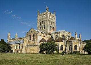
Tewkesbury is a medieval market town and civil parish in the north of Gloucestershire, England. The town grew following the construction of Tewkesbury Abbey in the twelfth century and played a significant role in the Wars of the Roses. It stands at the confluence of the River Severn and the River Avon, and thus became an important trading point, which continued as railways and, later, the M5 and M50 motorway connections were established. The town gives its name to the Borough of Tewkesbury, a local government district of Gloucestershire. The town lies on the border with Worcestershire, marked largely by the Carrant Brook.

BBC Radio Gloucestershire is the BBC's local radio station serving the county of Gloucestershire.

<span class="mw-page-title-main">Bishop's Cleeve</span> Human settlement in England

Bishop's Cleeve is a large village and civil parish in the Borough of Tewkesbury in the ceremonial county of Gloucestershire, England. The village lies at the foot of Cleeve Hill, the highest point in the Cotswolds. Bishop's Cleeve had a population of 10,612 in 2011, which has increased to 14,068 in the 2021 Census. The village is located 99 miles (159 km) from London, 13 miles (21 km) from Gloucester, 57 miles (92 km) from Birmingham and 44 miles (71 km) from Oxford. The village is also close to the towns of Cheltenham, Tewkesbury, Stratford-upon-Avon and Evesham.

<span class="mw-page-title-main">Tewkesbury (UK Parliament constituency)</span> Parliamentary constituency in the United Kingdom, 1997 onwards

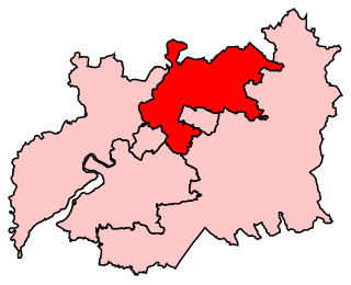
Tewkesbury is a constituency in Gloucestershire represented in the House of Commons of the UK Parliament since its 1997 recreation by Laurence Robertson, a Conservative.

<span class="mw-page-title-main">Innsworth</span> Human settlement in England

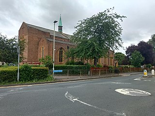
Innsworth is a suburb of Gloucester, it is also a civil parish and forms part of the borough of Tewkesbury, in the county of Gloucestershire, England. The parish population taken at the 2011 census was 2,468.

<span class="mw-page-title-main">Longlevens</span> Human settlement in England

Longlevens, originally Longleavens, is a suburb of Gloucester, in the unparished area of Gloucester, in the Gloucester district, in the county of Gloucestershire, England. It developed from a farmstead during the twentieth century, the name may be based on the old Roman name Colonia Glevensis, or the name could be based on an original field name "Long Elevens". This could have related to a long field about eleven acres therefore this could have been adopted as a name for the hamlet, first recorded in 1750, as part of the estate of Gloucester Cathedral. One of the oldest roads is 'The Avenue', which is shown on old maps as a number of farm cottages. The population of Longlevens was 9,532 at the time of the 2011 Census.

<span class="mw-page-title-main">Alderton, Gloucestershire</span> Human settlement in England

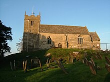
Alderton is a village and civil parish in the Tewkesbury district of Gloucestershire, England.

<span class="mw-page-title-main">Ashchurch</span> Human settlement in England

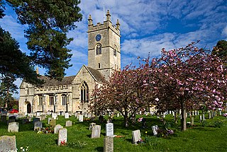
Ashchurch is a village and former civil parish, now in the parish of Ashchurch Rural, in the Tewkesbury district, in the county of Gloucestershire, England, 2 miles (3.2 km) east of the town of Tewkesbury, 11 miles (18 km) southwest of Evesham, 10 miles (16 km) north of Cheltenham, 13 miles (21 km) north-north east of Gloucester and 10 miles (16 km) south of Pershore.

<span class="mw-page-title-main">West Gloucestershire (UK Parliament constituency)</span> Parliamentary constituency in the United Kingdom, 1950–1997

West Gloucestershire was a parliamentary constituency in Gloucestershire, represented in the House of Commons of the Parliament of the United Kingdom.

Chosen Hill School is a large co-educational academy school in the village of Churchdown in Gloucestershire, England, between Cheltenham and Gloucester. It is also a Beacon School. The school was mentioned in 2008 in The Daily Telegraph as being the most over-subscribed school in Gloucestershire. In June 2009, it was recognised by Ofsted as 'outstanding'. The school has a large sixth form, with many students going on to higher education, many Russell Group universities.

Gloucester 1 is an English rugby union league which sits at the ninth level of league rugby union in England for teams based primarily in the county of Gloucestershire but also on occasion teams from Bristol. Promoted clubs move into Gloucester Premier and relegated clubs drop into either Gloucester 2 North or Gloucester 2 South depending on location. Each year clubs in this division also take part in the RFU Junior Vase - a level 9-12 national competition.

<span class="mw-page-title-main">Chosen Hill, Gloucestershire</span>

Chosen Hill rises above Churchdown in Gloucestershire, England, and is the site of a 11.5-hectare (28-acre) nature reserve.

<span class="mw-page-title-main">Borough of Tewkesbury</span> Non-metropolitan district in England

Tewkesbury is a local government district and borough in Gloucestershire, England. Named after its main town, Tewkesbury, the borough had a population of 85,800 in 2015. Other places in the borough include Ashchurch, Bishop's Cleeve, Churchdown and Winchcombe. It is administratively distinct from the parish of Tewkesbury, which is served by Tewkesbury Town Council.

<span class="mw-page-title-main">Gloucester and Cheltenham Green Belt</span>

The Gloucester and Cheltenham Green Belt is a green belt environmental and planning policy that regulates the rural space throughout mainly the South West region of England. It is completely within the county of Gloucestershire. Essentially, the function of the designation is to prevent further convergence between the conurbations of Gloucester and Cheltenham. It is managed by local planning authorities on guidance from central government.

References

  1. Though even this area is over 100 years old, see for example 1885 1:2500 map of the area.
  2. "UK Census 2001 Key Statistics: Parish Headcounts" datasets for Churchdown CP (Parish) - UK Office for National Statistics, also Largest village in England for comparison.
  3. "Parish population 2011". Archived from the original on 2 April 2015. Retrieved 1 April 2015.
  4. "History of Churchdown, in Tewkesbury and Gloucestershire | Map and description". Archived from the original on 22 January 2016. Retrieved 26 October 2015.
  5. Ordnance Survey Landranger and Explorer maps, OpenStreetMap as well as many others name it Churchdown Hill, while colloquial local usage tends to prefer Chosen Hill. Historical studies (see The Story of Churchdown) note a common etymology from a lost medieval or earlier root
  6. see The Story of Churchdown and Churchdown Gloucester - an official guide which discuss Mussell Well and the Roman Steps
  7. Churchdown Hill (Gloucestershire) Archived 19 February 2014 at the Wayback Machine radio transmitter status and details
  8. 1 2 "Churchdown Hill - Management Plan 2010 - 2015" (PDF). The Woodland Trust. Archived from the original (PDF) on 22 February 2014. Retrieved 9 February 2014.
  9. Friends of Churchdown Hill. "Walks on Churchdown Hill" (PDF). Churchdown Parish Council. Archived from the original (PDF) on 22 February 2014. Retrieved 9 February 2014.
  10. "Visit Woods: Churchdown Hill, Gloucestershire". The Woodland Trust. Archived from the original on 5 June 2016. Retrieved 8 October 2016.
  11. "Chosen Hill". Gloucestershire Wildlife Trust. Archived from the original on 2 August 2012. Retrieved 9 February 2014.
  12. "Churchdown Brookfield". Ordnance Survey. Archived from the original on 5 September 2014. Retrieved 7 September 2014.
  13. "Churchdown St. John's". Ordnance Survey. Archived from the original on 7 September 2014. Retrieved 7 September 2014.
  14. The Gloucester & Cheltenham Railway and the Leckhampton Quarry Tramroads. Locomotion Papers Number Forty-Three. D. E. Bick, Oakwood Press, 1968.
  15. "The Churchdown Magazine", Issue 127 JAN/FEB 06
  16. "Magazines | MyChurchdown Magazine". Archived from the original on 9 July 2011.
  17. "My Churchdown: Welcome to October". Archived from the original on 5 November 2010.
  18. Gloucestershire County Council - Community information for Churchdown including list of schools
  19. Geograph Archived 20 December 2016 at the Wayback Machine - picture and description of skate facility
  20. Chose Hill Former Pupils RFC Archived 31 May 2019 at the Wayback Machine - Rugby Club Web site
  21. Friends of Churchdown Hill - Map Archived 22 February 2014 at the Wayback Machine See "Historical Notes" section.
  22. "Living in Churchdown". The Property Centre. Archived from the original on 20 August 2020. Retrieved 20 August 2020.
  23. Churchdown Community Association web site Archived 25 January 2012 at the Wayback Machine detailing the Community Centre building and Social Club
  24. Herbert Howells: Piano Quartet in A minor, op.21 (Stainer and Bell, 1918). The dedication is on the first page of the score.
  25. Andrews, Paul (1997). Herbert Howells Piano Music, Volume 1. London: Thames Publishing. ISBN   978-1-84609-722-5.