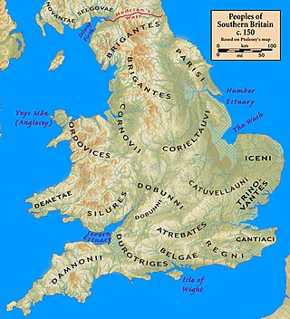
The Dumnonii or Dumnones were a British tribe who inhabited Dumnonia, the area now known as Cornwall and Devon in the further parts of the South West peninsula of Britain, from at least the Iron Age up to the early Saxon period. They were bordered to the east by the Durotriges tribe.

A fogou or fougou is an underground, dry-stone structure found on Iron Age or Romano-British-defended settlement sites in Cornwall. The original purpose of a fogou is uncertain today. Colloquially called vugs, vows, foggos, giant holts, or fuggy holes in various dialects, fogous have similarities with souterrains or earth-houses of northern Europe and particularly Scotland, including Orkney. Fewer than 15 confirmed fogous have been found.

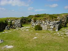
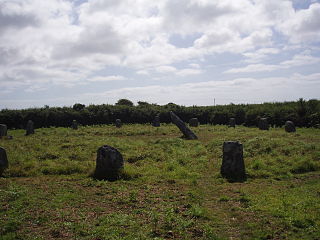
Carn Euny is an archaeological site near Sancreed, on the Penwith peninsula in Cornwall, United Kingdom with considerable evidence of both Iron Age and post-Iron Age settlement. Excavations on this site have shown that there was activity at Carn Euny as early as the Neolithic period. There is evidence that shows that the first timber huts there were built about 200 BC, but by the 1st century BC, these had been replaced by stone huts. The remains of these stone huts are still visible today.

Souterrain is a name given by archaeologists to a type of underground structure associated mainly with the European Atlantic Iron Age.
The history of Cornwall goes back to the Paleolithic, but in this period Cornwall only had sporadic visits by groups of humans. Continuous occupation started around 10,000 years ago after the end of the last ice age. When recorded history started in the first century BCE, the spoken language was Common Brittonic, and that would develop into Southwestern Brittonic and then the Cornish language. Cornwall was part of the territory of the tribe of the Dumnonii that included modern-day Devon and parts of Somerset. After a period of Roman rule, Cornwall reverted to rule by independent Romano-British leaders and continued to have a close relationship with Brittany and Wales as well as southern Ireland, which neighboured across the Celtic Sea. After the collapse of Dumnonia, the remaining territory of Cornwall came into conflict with neighbouring Wessex.

St Columb Major is a town and civil parish in Cornwall, England, United Kingdom. Often referred to locally as St Columb, it is approximately seven miles (11 km) southwest of Wadebridge and six miles (10 km) east of Newquay The designation Major distinguishes it from the nearby settlement and parish of St Columb Minor on the coast. An electoral ward simply named St Columb exists with a population at the 2011 census of 5,050. The town is named after the 6th-century AD Saint Columba of Cornwall, also known as Columb.

Pendeen is a village and ecclesiastical parish on the Penwith peninsula in Cornwall, England. It is 3 miles north-northeast of St Just and 7 mi (11 km) west of Penzance. It lies along the B3306 road which connects St Ives to Land's End and the A30 road.

St Buryan is a village and former civil parish, now in the parish of St Buryan, Lamorna and Paul in Cornwall, England, United Kingdom. In 2011 the parish had a population of 1412.

Sancreed is a village and civil parish in Cornwall, England, United Kingdom, approximately three miles (5 km) west of Penzance.

The Hurlers is a group of three stone circles in the civil parish of St Cleer, Cornwall, England, UK. The site is half-a-mile (0.8 km) west of the village of Minions on the eastern flank of Bodmin Moor, and approximately four miles (6 km) north of Liskeard.

St Agnes is a civil parish and a large village on the north coast of Cornwall, England, United Kingdom. The village is about five miles (8 km) north of Redruth and ten miles (16 km) southwest of Newquay. An electoral ward exists stretching as far south as Blackwater. The population at the 2011 census was 7,565.

Manaccan is a civil parish and village on the Lizard peninsula in south Cornwall, England, United Kingdom. The village is about five miles (8 km) south-southwest of Falmouth.

William Copeland Borlase was a British antiquarian and Liberal politician who sat in the House of Commons from 1880 until 1887 when he was ruined by bankruptcy and scandal.
Bosporthennis is a hamlet south of Treen in the civil parish of Zennor on the Penwith peninsula in west Cornwall, England, United Kingdom.
Caer Bran Hill Fort is an archaeological site near Sancreed and Carn Euny Iron Age village, on the Penwith peninsula in Cornwall.

Bartinney Castle is an Iron Age enclosure located in the Penwith Peninsula of Southwest Cornwall, England, it is surrounded by a circular earthwork standing on a hill surrounded by various archaeological prehistoric remains, including ancient settlements, field systems, tumuli and cairns.

Cornish promontory forts, commonly known in Cornwall as cliff castles, are coastal equivalents of the hill forts and Cornish "rounds" found on Cornish hilltops and slopes. Similar coastal forts are found on the north–west European seaboard, in Normandy, Brittany and around the coastlines of the British Isles, especially in Wales, Scotland and Ireland. Many are known in southwest England, particularly in Cornwall and its neighbouring county, Devon. Two have been identified immediately west of Cornwall, in the Isles of Scilly.

Halangy Down is a prehistoric settlement located on the island of St Mary's, in the Isles of Scilly. The ancient site covers the lower slope of Halangy Down hill, overlooking the coastal inlet between the island of St. Mary's and Tresco Island. On the site are the remains of an Iron Age village, two entrance graves, prehistoric field systems, standing stones, post-medieval breastworks, and a Victorian kelp pit. The settlement was in continuous use for 500 years, from the late Iron Age until the end of the Roman occupation in Britain.