Councils of Tasmania are the 29 administrative districts of the Australian state of Tasmania. Local government areas (LGAs), more generally known as councils, are the tier of government responsible for the management of local duties such as road maintenance, town planning and waste management.

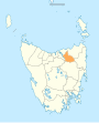
Launceston is a city in the north of Tasmania, Australia, at the confluence of the North Esk and South Esk rivers where they become the Tamar River (kanamaluka). As of 2021, the Launceston urban area has a population of 90,953. Launceston is the second most populous city in Tasmania after the state capital, Hobart. As of 2020, Launceston is the 18th largest city in Australia. Launceston is the fifth-largest inland city and the ninth-largest non-capital city in Australia. Launceston is regarded as the most livable regional city, and was one of the most popular regional cities to move to in Australia from 2020 to 2021. Launceston was named Australian Town of the Year in 2022.
Dorset Council is a local government body in Tasmania, located in the far north-east of the state mainland. Dorset is classified as a rural local government area and has a population of 6,652. The major towns and localities of the region include Bridport, Derby and Ringarooma with Scottsdale the regional centre. Dorset was placed under a board of inquiry on 2 August 2023 and is currently under the supervision of commissioner Wardlaw. The current general manager is John Marik.

Meander Valley Council is a local government body in northern Tasmania. It covers the western outskirts of Launceston, and further westward along the Meander River. Meander Valley Council is classified as a rural local government area and has a population of 19,713. Major towns and localities of the region include Elizabeth Town, Mole Creek, Westbury and the principal town of Deloraine.
West Tamar Council is a local government body in Tasmania, situated along the western side of the Tamar River in the north of the state. West Tamar is classified as an urban local government area and has a population of 23,769, it extends from the outer reaches of north-west Launceston and includes the towns and localities of Beaconsfield, Beauty Point and Legana.

Central Highlands Council is a local government body in Tasmania, encompassing the Central Highlands region of the state. Central Highlands is classified as a rural local government area and has a population of 2,144, the two largest towns are Bothwell and Hamilton.

Northern Midlands Council is a local government body in Tasmania, extending south of Launceston into the northern region of the Tasmanian central midlands. Northern Midlands is classified as a rural local government area and has a population of 13,300, the major population centres and localities of the region include Campbell Town, Evandale, Longford, and Perth.

Southern Midlands is a local government body in Tasmania, covering the southern region of the Tasmanian central midlands. Southern Midlands is classified as a rural local government area and has a population of 6,118, the major localities of the region include Campania, Kempton, Mangalore and the principal town of Oatlands.
Newnham is a residential locality in the local government area (LGA) of Launceston in the Launceston LGA region of Tasmania. The locality is about 7 kilometres (4.3 mi) north of the town of Launceston. The 2016 census recorded a population of 6453 for the state suburb of Newnham. It is a suburb of Launceston. Newnham is located on the East Tamar Highway, on the eastern side of the Tamar River.

Lilydale, originally known as Upper Piper, is a small town in northern Tasmania, Australia. The town is 28 kilometres (17 mi) northeast of Launceston and is a part of the Launceston municipality, except for about 4% which is in the Dorset LGA. It is located near Mount Arthur. At the 2016 census, Lilydale had a population of 277. The town's notable attractions include the Lilydale Falls, two small waterfalls, Mount Arthur, and, along the main street, a series of telegraph poles painted with murals.
Underwood is a rural locality and town in the local government area of Launceston, in the Northern region of Tasmania. It is located about 22 kilometres (14 mi) north-east of the city of Launceston. The 2016 census determined a population of 363 for the state suburb of Underwood.

Trevallyn is a residential locality in the local government areas (LGAs) of Launceston (25%) and West Tamar (75%) in the Launceston LGA region of Tasmania. The locality is about 3 kilometres (1.9 mi) west of the city of Launceston. The 2016 census recorded a population of 4562 for the state suburb of Trevallyn. It is a suburb of Launceston.
George Town Council is a local government body in northern Tasmania, situated north of Launceston. The George Town local government area is classified as rural and has a population of 6,931, it encompasses the principal town, George Town, and the nearby localities including Hillwood, Low Head and Pipers River.

Burnie City Council is a local government body in Tasmania, located in the city and surrounds of Burnie in the north-west of the state. The Burnie local government area is classified as urban and has a population of 19,348, which also encompasses Cooee, Hampshire, Natone and Ridgley.

Mowbray is a suburb of Launceston in the Australian state of Tasmania and is the site of Mowbray Racecourse, home of the Launceston Cup. Mowbray also contains the minor suburbs of Mowbray Heights and Vermont. The suburb of Mowbray is located on a flat-topped, alluvial shelf, known as Mowbray Hill, roughly 28m above the Tamar River and its flood plains.
Rocherlea is a residential locality in the local government area (LGA) of Launceston in the Launceston LGA region of Tasmania. The locality is about 9 kilometres (5.6 mi) north of the town of Launceston. The 2016 census recorded a population of 1081 for the state suburb of Rocherlea. It is a northern suburb of Launceston, about ten minutes drive from the Launceston CBD and on the way to Lilydale. It has a community centre, church and op shop.

The Launceston tramway network served the city of Launceston, Tasmania in Australia from 1911 until 1952.
Targa is a rural locality in the local government area of Launceston, in the Northern region of Tasmania. It is located about 33 kilometres (21 mi) north-east of the city of Launceston. The 2016 census determined a population of 38 for the state suburb of Targa.
Blessington is a rural locality in the local government areas of Launceston and Northern Midlands, in the Northern and Central regions of Tasmania. It is located about 32 kilometres (20 mi) south-east of the city of Launceston. The 2016 census determined a population of 93 for the state suburb of Blessington.
Turners Marsh is a rural locality in the local government area (LGA) of Launceston in the Launceston LGA region of Tasmania. The locality is about 19 kilometres (12 mi) north of the town of Launceston. The 2016 census recorded a population of 254 for the state suburb of Turners Marsh.