Cold Bay, Alaska

Last updated

Cold Bay
Udaamagax, Pualu
Aerial of runway at Cold Bay, Izembek National Wildlife Refuge.jpg
Aerial view of Cold Bay taken during the early 21st century.
Cold Bay Airport 's runways are visible.
USA Alaska location map.svg
Red pog.svg
Cold Bay
Location in Alaska
Coordinates: 55°12′33″N162°42′51″W / 55.20917°N 162.71417°W / 55.20917; -162.71417
CountryUnited States
State Alaska
Borough Aleutians East
Incorporated January 1982
Government
  Type Mayor–council
   Mayor Candace Schaack Nielsen [1]
   State senator Lyman Hoffman (D) [2]
   State rep. Bryce Edgmon (I)
Area
[3]
  Total68.06 sq mi (176.26 km2)
  Land53.41 sq mi (138.34 km2)
  Water14.64 sq mi (37.92 km2)
Elevation
138 ft (42 m)
Population
 (2020)
  Total50
  Density0.94/sq mi (0.36/km2)
Time zone UTC−9 (Alaska (AKST))
  Summer (DST) UTC−8 (AKDT)
ZIP code
99571
Area code 907 (local prefix: 532)
FIPS code 02-16530
GNIS feature ID 1418448
Website https://www.coldbayak.org
[4]

Cold Bay (Aleut : Udaamagax,; [5] Sugpiaq: Pualu [6] ) is a city in Aleutians East Borough, Alaska, United States. As of the 2010 census, the population was 108, but at the 2020 census this had reduced to 50.

Contents

Cold Bay is one of the main commercial centers of the Alaska Peninsula, which extends west towards the Aleutian Islands, and is home to Cold Bay Airport.

History

There is evidence of prehistoric occupation by Aleuts and later Russian encampments. Cold Bay's significance to American history began with the Japanese invasion of the Aleutians in World War II. General Simon Bolivar Buckner, Jr. ordered the creation of Fort Randall, an airbase on the shores of Cold Bay, in 1942 as a part of a general expansion of American assets in the Aleutians. It (along with Otter Point) served as a base for the 11th Air Force to provide protection to the only deep water port in the Aleutians at the time, Dutch Harbor.

This protection was necessary when during Yamamoto's Midway Campaign, a diversionary attack was launched against Dutch Harbor. The initial attack was repulsed by the surprise presence of P-40s stationed here. A second larger attack with its own fighter escort the next day caused minor damage. Later, with the victory in the Pacific, the forces grew to 20,000 troops. The quonset huts used to house this massive encampment still stand around the community. It also was a base of operations for the US Navy with the seaplane tender USS Casco (AVP-12) among the ships based in Cold Bay. [7]

In the spring and summer of 1945, Cold Bay was the site of the largest and most ambitious transfer program of World War II, Project Hula, in which the United States transferred dozens of ships and craft to the Soviet Union and trained Soviet personnel in their operation in anticipation of the Soviet Union entering the war against Japan.

In later decades, control of the airfield passed to civil authorities, who maintained it as a useful refueling and emergency landing location for great circle flights from the west coast of the United States to East Asia. A Distant Early Warning Line station established nearby was eventually decommissioned.

During the 1980s, deregulation of the airline industry under President Ronald Reagan caused many of the compelling interests[ who? ] supporting the need for the community to evaporate. Today, Cold Bay is still occasionally used for emergency or precautionary landings of commercial flights, and is also a hub for traffic from Anchorage and Seattle to the small communities around it.

Geography

Cold Bay is located at 55°12′33″N162°42′51″W / 55.20917°N 162.71417°W / 55.20917; -162.71417 (55.209038, -162.714298). [8] It is west of Hawaii.

According to the U.S. Census Bureau, the city has a total area of 70.9 square miles (184 km2), of which, 54.4 square miles (141 km2) of it is land and 16.6 square miles (43 km2) of it (23.34%) is water.

Cold Bay holds the record for most overcast community in America. [9]

Climate

Climate chart for Cold Bay Monthly Climate Normals (1991-2020) - Cold Bay Area, AK(ThreadEx).svg
Climate chart for Cold Bay

Cold Bay has an either an ocean-moderated subarctic climate (Köppen climate classification: Dfc) if the 0 °C isotherm is used, or a subpolar oceanic climate (Köppen climate classification: Cfc) if the −3 °C (26.6 °F) isotherm is used, both of those climate being typical of southwest Alaska, though the summers are almost cool enough to qualify as a tundra (Köppen climate classification: ET). Cold Bay is considered the cloudiest place in the United States, with an average of 304 days of heavy overcast (covering over 3/4 of the sky). [9]

Cold Bay's recorded temperature range is between 78 °F (26 °C) and −13 °F (−25 °C). [10] The coldest daytime maximum on record is 0 °F (−18 °C), while the annual coldest maximum between 1991 and 2020 was at 16 °F (−9 °C). [10] With warm summer days being rare, nights remain chilly also during the warmer season. The warmest recorded overnight low is at a very modest 57 °F (14 °C) and the annual average warmest night tends to fall to 53 °F (12 °C). [10] Many years fail to break 68 °F (20 °C) during the warmest afternoon. [10]

Climate data for Cold Bay Airport, Alaska (19912020 normals, [lower-alpha 1] extremes 1942present [lower-alpha 2] )
MonthJanFebMarAprMayJunJulAugSepOctNovDecYear
Record high °F (°C)59
(15)
54
(12)
56
(13)
60
(16)
68
(20)
72
(22)
77
(25)
78
(26)
70
(21)
69
(21)
59
(15)
62
(17)
78
(26)
Mean maximum °F (°C)43.5
(6.4)
43.9
(6.6)
44.6
(7.0)
49.7
(9.8)
56.2
(13.4)
61.2
(16.2)
64.7
(18.2)
65.8
(18.8)
60.1
(15.6)
54.7
(12.6)
49.2
(9.6)
45.2
(7.3)
67.7
(19.8)
Mean daily maximum °F (°C)33.2
(0.7)
35.0
(1.7)
35.4
(1.9)
40.2
(4.6)
46.5
(8.1)
52.1
(11.2)
56.2
(13.4)
57.2
(14.0)
53.4
(11.9)
46.5
(8.1)
39.9
(4.4)
35.6
(2.0)
44.3
(6.8)
Daily mean °F (°C)28.4
(−2.0)
30.2
(−1.0)
29.9
(−1.2)
35.0
(1.7)
41.0
(5.0)
47.1
(8.4)
51.5
(10.8)
52.6
(11.4)
48.4
(9.1)
41.3
(5.2)
35.3
(1.8)
30.8
(−0.7)
39.3
(4.1)
Mean daily minimum °F (°C)23.7
(−4.6)
25.5
(−3.6)
24.4
(−4.2)
29.8
(−1.2)
35.5
(1.9)
42.0
(5.6)
46.9
(8.3)
48.1
(8.9)
43.4
(6.3)
36.1
(2.3)
30.6
(−0.8)
25.9
(−3.4)
34.3
(1.3)
Mean minimum °F (°C)6.7
(−14.1)
8.2
(−13.2)
9.7
(−12.4)
18.0
(−7.8)
25.7
(−3.5)
33.7
(0.9)
40.8
(4.9)
39.2
(4.0)
33.2
(0.7)
25.2
(−3.8)
18.0
(−7.8)
10.8
(−11.8)
2.1
(−16.6)
Record low °F (°C)−13
(−25)
−9
(−23)
−13
(−25)
4
(−16)
18
(−8)
27
(−3)
33
(1)
32
(0)
26
(−3)
6
(−14)
1
(−17)
−9
(−23)
−13
(−25)
Average precipitation inches (mm)3.38
(86)
3.17
(81)
2.98
(76)
2.70
(69)
2.64
(67)
2.74
(70)
2.51
(64)
3.71
(94)
4.50
(114)
4.93
(125)
4.99
(127)
4.42
(112)
42.67
(1,084)
Average snowfall inches (cm)12.6
(32)
10.0
(25)
12.8
(33)
6.4
(16)
1.2
(3.0)
0.0
(0.0)
0.0
(0.0)
0.0
(0.0)
0.0
(0.0)
2.0
(5.1)
8.2
(21)
14.1
(36)
67.3
(171)
Average precipitation days (≥ 0.01 in)20.520.119.418.917.817.419.821.322.624.824.423.4250.4
Average snowy days (≥ 0.1 in)13.012.713.39.12.40.00.00.00.13.19.714.277.6
Average relative humidity (%)84.383.582.882.583.586.388.389.586.482.883.586.385.0
Average dew point °F (°C)25.9
(−3.4)
24.1
(−4.4)
25.7
(−3.5)
27.3
(−2.6)
34.0
(1.1)
40.8
(4.9)
46.6
(8.1)
48.4
(9.1)
44.2
(6.8)
36.0
(2.2)
30.4
(−0.9)
30.6
(−0.8)
34.5
(1.4)
Source 1: NOAA (relative humidity and dew point 1961-1990) [11]
Source 2: National Weather Service [10] [12]

See or edit raw graph data.

Notes
  1. Mean monthly maxima and minima (i.e. the highest and lowest temperature readings during an entire month or year) calculated based on data at said location from 1991 to 2020.
  2. Records for Cold Bay have been kept at the Cold Bay Airport since March 1950 and at Thornbrough Air Force Base from June 1942 to February 1950. For more information, see ThreadEx

Demographics

Historical population
CensusPop.Note
1890 231
1960 86
1970 256197.7%
1980 228−10.9%
1990 148−35.1%
2000 88−40.5%
2010 10822.7%
2020 50−53.7%
U.S. Decennial Census [13]

Cold Bay first appeared on the 1890 U.S. Census as the unincorporated area of "Thin Point", which included Thin Point & Cold Bay (including two canneries and Cold Bay Salting Station). It reported 231 residents, of which 110 were White, 106 were Asian, ten were Creole (Mixed Russian & Native), three were Native and two were Other. [14] It would not appear again until 1960, when it reported as the unincorporated village of Cold Bay. It was made a census-designated place (CDP) in 1980 and incorporated in 1982.

Cold Bay is a highly transient community, lacking the generational attachment characteristic of the surrounding native villages. Residents, drawn to the area largely by the Wildlife Refuge, Weather Service, or air traffic jobs, rarely stay more than a year in Cold Bay.

2000 census

At the 2000 census, there were 88 people, 36 households and 18 families residing in the city. The population density was 1.6 per square mile (0.6/km2). There were 98 housing units at an average density of 1.8 per square mile (0.7/km2). The racial makeup of the city was 72% White, 3% Black or African American, 17% Native American, 5% Asian, 2% Pacific Islander, and 1% from two or more races. 2% of the population were Hispanic or Latino of any race.

There were 36 households, of which 33% had children under the age of 18 living with them, 44% were married couples living together, 3% had a female householder with no husband present, and 50% were non-families. 36% of all households were made up of individuals, and none had someone living alone who was 65 years of age or older. The average household size was two and the average family size was three.

Age distribution was 24% under the age of 18, 9% from 18 to 24, 40% from 25 to 44, 27% from 45 to 64. The median age was 34 years. For every 100 females, there were 184 males. For every 100 females age 18 and over, there were 205 males.

The median household income was $55,750, and the median family income was $64,375. Males had a median income of $36,250 versus $38,333 for females. The per capita income for the city was $20,037. There were no families and 27% of the population living below the poverty line, including no one under eighteen or over 64.

Religion

Cold Bay has a significant Baptist population. The city's only church is Cold Bay Community Chapel, a member of the Southern Baptist Convention. [15]

Economy

Cold Bay has one store, the Bearfoot Inn Alaska, formerly known as the World-famous Weathered Inn. It supplies groceries, clothing and small trinkets to the residents of Cold Bay and other communities within the Aleutians East Borough, although many residents order groceries and supplies from suppliers in Anchorage and Seattle. The Bearfoot Inn also offers lodging with its 8-room hotel and 6-room bunk house. Within the main building there is the Bearfoot Inn Bar which is open 3 to 6 days a week depending on the season. Bearfoot Inn is within walking distance of the airport.

The Cold Bay Lodge is the only restaurant in town. The lodge can accommodate up to about 40 people (38 beds), offers wireless Internet access, holds a liquor license, is less than a mile from the airport and offers trinkets and snacks.

Culture

Traditions

A major community event is the Silver Salmon Derby, a fishing contest that takes place every fall. Participants vie in both adult and child categories for cash prizes for the largest fish. A raft race and "Polar Bear Jump" are also held. The Derby concludes with a banquet and door prize giveaway at the town community hall.

Parks and recreation

Izembek National Wildlife Refuge

The 498,000-acre (2,020 km2) Izembek refuge was established in 1960. It encompasses several large lagoons, including the 30-mile (48 km) long Izembek Lagoon, which serve as a food source and shelter for a large migratory bird population.

Approximately 150,000 Pacific black brant, 62,000 emperor geese, 50,000 Taverner's Canada geese, 300,000 ducks, and 80,000 shore birds stop over in the Izembek area during migration and as many as 50,000 Steller's eiders find winter grounds there. [16]

Government

Cold Bay was incorporated as a city in January 1982. [17] Cold Bay is classified by the state government as a second-class city. [18] As such, it is governed by a seven-member city council, which elects the city's mayor from among its membership. The current mayor is Harold Kremer. The city clerk is currently a vacant position.

Mayors

The following individuals have served as the mayor of Cold Bay since its incorporation:

TenureName
1982–1984Monte M. Larsh [19] [20]
1984–1985Donald Dennis [21]
1985 - 1988[ data missing ]Clayton Brown [22]
1988-1997Gerry Dias [23]
1997–1998Alan Ellis [24]
1998–1999Jim Blowers [25]
1999–2004Harold (Happy) Kremer
2004–2010John Maxwell [26] [27] [28] [29]
2010–2015Jorge Lopez
2015–2017Candace Schaack
2017–2019Dailey Schaack
2020–2021David Lyons
2021–2021Harold (Happy) Kremer
2021-2022Robert Nielsen
2022-2023Candace (Schaack) Nielsen

Education

Cold Bay School

The Cold Bay School was the community's public grade school, operated by the Aleutians East Borough School District (AEBSD), until its closure in May 2015. AEBSD's school board voted to close Cold Bay School following the conclusion of the 2014–2015 school year due to a decline in enrollment, which led to the loss of state funding. [30] The school employed one teacher and served between four and nine students in its last years.[ citation needed ] The loss of the school caused an exodus of the remaining school-aged children until, by 2015, only one was left. [30]

Circa 1978 the school, then a part of the Aleutian Region School District, had two teachers, [31] and 37 students. [32] In the 1980s, the school typically enrolled around 30 students. [33] In 1985 it reached peak enrollment, with 50 students and four teachers. [33] Despite its remote location, the school was involved in state and national activities, such as hosting the military's "Operation Arctic Care" outreach health program in 2002, and by briefly becoming involved with reporting for CNN Student Bureau that same year.[ citation needed ]

The school building was used to house passengers of flights which made emergency landings in Cold Bay. [34]

Infrastructure

Transportation

Road

Cold Bay has approximately 40 miles (64 km) of gravel roads, and a state-owned paved highway. [18]

Water

The Alaska Marine Highway travels between Cold Bay and Kodiak twice a month between May and October, and cargo ships visit the city monthly from Seattle, Washington. [18] Currently, the city only has a dock and a seaplane base, but the city hopes to develop a breakwater, boat harbor and boat launch. [18]

Air

Cold Bay is serviced by Cold Bay Airport, holding the fifth-largest runway in Alaska,[ citation needed ] and a second, smaller one. Regional flights occur six times a week.

Related Research Articles

<span class="mw-page-title-main">Aleutians East Borough, Alaska</span> Borough in Alaska, United States

Aleutians East Borough is a 2nd class borough in the U.S. state of Alaska. As of the 2020 census the borough's population was 3,420. The borough seat is Sand Point.

<span class="mw-page-title-main">Akutan, Alaska</span> City in Alaska, United States

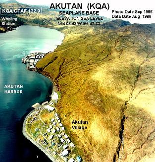
Akutan is a city on Akutan Island in the Aleutians East Borough of the Aleutian Islands in Alaska, United States. The population was 1,589 at the 2020 census, up from 1,027 in 2010, making it the 4th fastest-growing city of the decade in Alaska. Akutan Harbor is adjacent.

<span class="mw-page-title-main">False Pass, Alaska</span> City in Alaska, United States

False Pass is a city on Unimak Island, in the Aleutians East Borough of southwestern Alaska, United States. Although the population was marked 397 including seasonal fish processing plant workers at the 2020 census, approximately 35 residents call it home year-round.

<span class="mw-page-title-main">King Cove, Alaska</span> City in Alaska, United States

King Cove is a city in Aleutians East Borough, Alaska, United States. As of the 2010 census, its population was 938, up from 792 in 2000, but at the 2020 census this had reduced to 757.

Nelson Lagoon is a census-designated place (CDP) in Aleutians East Borough, Alaska, United States. At the 2020 census the population was 41, down from 52 in 2010 and 83 in 2000.

<span class="mw-page-title-main">Sand Point, Alaska</span> City in Alaska, United States

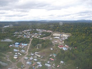
Sand Point, also known as Popof Island, is a city in Aleutians East Borough, Alaska, United States. At the 2010 census the population was 976, up from 952 in 2000, but by the 2020 Census this had reduced to 578. It is on northwestern Popof Island, one of the Shumagin Islands, off the Alaska Peninsula. It is the borough seat of Aleutians East Borough, and is near the entrance to the Bering Sea.

<span class="mw-page-title-main">Adak, Alaska</span> City in Alaska, United States

Adak, formerly Adak Station, is a city located on Adak Island, in the Aleutians West Census Area, Alaska, United States. At the 2020 census, the population was 171, down from 326 in 2010. It is the westernmost municipality in the United States and the southernmost city in Alaska. The city is the former location of the Naval Air Facility Adak, NAVFAC Adak.

<span class="mw-page-title-main">Atka, Alaska</span> City in Alaska, United States

Atka is a small city located on the east side of Atka Island, in Aleutians West Census Area, Alaska, United States. The population was 53 at the 2020 census, down from 61 in 2010.

<span class="mw-page-title-main">St. George, Alaska</span> City in Alaska, United States

St. George is a city in Aleutians West Census Area, Alaska, United States. It is the main settlement of St. George Island in the Pribilofs, a small island group in the Bering Sea. At the 2010 census the population was 102, down from 152 in 2000.

<span class="mw-page-title-main">St. Paul, Alaska</span> City in Alaska, United States

St. Paul is a city in the Aleutians West Census Area, Alaska, United States. It is the main settlement of Saint Paul Island in the Pribilofs, a small island group in the Bering Sea. The population was 413 at the 2020 census, down from 479 in 2010. Saint Paul Island is known as a birdwatching haven.

<span class="mw-page-title-main">Unalaska, Alaska</span> Town in Alaska

The City of Unalaska is the main population center in the Aleutian Islands. The city is in the Aleutians West Census Area, a regional component of the Unorganized Borough in the U.S. state of Alaska. Unalaska is located on Unalaska Island and neighboring Amaknak Island in the Aleutian Islands off mainland Alaska. The population was 4,254 at the 2020 census, which is 81% of the entire Aleutians West Census Area. Unalaska is the second largest city in the Unorganized Borough, behind Bethel.

<span class="mw-page-title-main">Eek, Alaska</span> City in Alaska, United States

Eek is a city in Bethel Census Area, Alaska, United States. As of the 2020 census there were 404 residents, the majority being Alaska Natives.

<span class="mw-page-title-main">Goodnews Bay, Alaska</span> City in Alaska, United States

Goodnews Bay is a city in Bethel Census Area, Alaska, United States. As of the 2010 census, the population of the city was 243, up from 230 in 2000.

<span class="mw-page-title-main">Chignik, Alaska</span> City in Alaska, United States

Chignik is a city in Lake and Peninsula Borough, Alaska, United States. It is two hundred and fifty miles southwest of Kodiak. At the 2020 census the population was 97, up from 91 in 2010.

<span class="mw-page-title-main">Wainwright, Alaska</span> City in Alaska, United States

Wainwright, also known as Ulguniq or Kuuk, is a city in North Slope Borough, Alaska, United States. At the 2020 census the population was 628, making it the third largest city in the North Slope Borough, up from 556 in 2010. The community was named after Wainwright Lagoon, which in turn was named after Lt. John Wainwright, an officer under Capt. F. W. Beechey, who were the first non-native people to travel to the lagoon in 1826. An unincorporated area known as Wainwright Inlet by 1890, Wainwright was founded as an incorporated municipality in 1904.

<span class="mw-page-title-main">Deering, Alaska</span> City in Alaska, United States

Deering is a city in the Northwest Arctic Borough in the U.S. state of Alaska. It is located on a sandy spit on the Seward Peninsula where the Inmachuk River flows into Kotzebue Sound, 92 km (57 mi) southwest of Kotzebue.

<span class="mw-page-title-main">Angoon, Alaska</span> City in Alaska, United States

Angoon is a city on Admiralty Island in Hoonah-Angoon Census Area, Alaska, United States. At the 2000 census the population was 572; by the 2010 census the population had declined to 459. The name in Tlingit, Aangóon, means roughly "isthmus town."

<span class="mw-page-title-main">Hooper Bay, Alaska</span> Town in Alaska

Hooper Bay is a city in Kusilvak Census Area, Alaska, United States. At the 2020 census the population was 1,375, up from 1,093 in 2010.

<span class="mw-page-title-main">Russian Mission, Alaska</span> City in Alaska, United States

Russian Mission is a city in Kusilvak Census Area, Alaska. It was the location of a fur trading post of the Russian-American Company in 1842. After the sale of Russian-American possessions to the United States in 1867, it was officially named Russian Mission in the early 1900s. The sale of alcohol is prohibited. At the 2020 census the population was 421, up from 312 in 2010.

References

  1. 2023 Alaska Municipal Officials Directory (PDF). Juneau: Alaska Municipal League. January 2023. p. 59. Retrieved November 12, 2023.
  2. "Senator Lyman Hoffman". Alaska Senate Majority. Alaskasenate.org. Archived from the original on April 8, 2020. Retrieved November 16, 2019.
  3. "2020 U.S. Gazetteer Files". United States Census Bureau. Retrieved October 29, 2021.
  4. "City of Cold Bay". Geographic Names Information System . United States Geological Survey, United States Department of the Interior . Retrieved September 11, 2018.
  5. Bergsland, K. (1994). Aleut Dictionary. Fairbanks: Alaska Native Language Center.
  6. "AP-PER - Perryville Area" (PDF). Alaska Native Language Archive. Archived (PDF) from the original on August 26, 2021.
  7. "Dictionary of American Naval Fighting Ships". U.S. Department of the Navy. Archived from the original on May 2, 2013.
  8. "US Gazetteer files: 2010, 2000, and 1990". United States Census Bureau. February 12, 2011. Retrieved April 23, 2011.
  9. 1 2 "Cloudiest Places in United States - Current Results". Archived from the original on January 18, 2024.
  10. 1 2 3 4 5 "NOAA Online Weather Data". National Weather Service. Retrieved August 11, 2022.
  11. "U.S. Climate Normals Quick Access". National Oceanic and Atmospheric Administration. Archived from the original on September 3, 2023. Retrieved August 11, 2022.
  12. "WMO Climate Normals for COLD BAY, AK 1961–1990". National Oceanic and Atmospheric Administration. Archived from the original on September 3, 2023. Retrieved September 3, 2020.
  13. "Census of Population and Housing". Census.gov. Retrieved June 4, 2016.
  14. "Report on Population and Resources of Alaska at the Eleventh Census: 1890" (PDF). United States Census Bureau. Government Printing Office.
  15. "Cold Bay Community Chapel". FaithStreet. Retrieved October 23, 2015.
  16. Izembek National Wildlife Refuge website Archived September 25, 2006, at the Wayback Machine
  17. 1996 Alaska Municipal Officials Directory. Juneau: Alaska Department of Community and Regional Affairs / Alaska Municipal League. January 1996. p. 42.
  18. 1 2 3 4 "Cold Bay". Southwest Alaska Municipal Conference. Archived from the original on October 14, 2015. Retrieved October 23, 2015.
  19. Alaska Municipal Officials Directory 1983. Juneau: Alaska Department of Community and Regional Affairs / Alaska Municipal League. 1983. p. 24.
  20. Alaska Municipal Officials Directory 1984. Juneau: Alaska Department of Community and Regional Affairs / Alaska Municipal League. 1984. p. 25.
  21. Alaska Municipal Officials Directory 1985. Juneau: Alaska Department of Community and Regional Affairs / Alaska Municipal League. 1985. p. 35.
  22. Personal knowledge
  23. Gerry Dias
  24. 1998 Alaska Municipal Officials Directory. Juneau: Alaska Department of Community and Regional Affairs / Alaska Municipal League. January 1998. p. 42.
  25. 1999 Alaska Municipal Officials Directory. Juneau: Alaska Department of Community and Regional Affairs / Alaska Municipal League. January 1999. p. 42.
  26. "PUBLIC LANDS: 'The scariest plane ride of your life'". www.eenews.net. Retrieved October 24, 2015.
  27. 2005 Alaska Municipal Officials Directory. Juneau: Alaska Department of Community and Regional Affairs / Alaska Municipal League. January 2005. p. 43.
  28. 2007 Alaska Municipal Officials Directory. Juneau: Alaska Department of Commerce, Community and Economic Development / Alaska Municipal League. March 2007. p. 44.
  29. 2008 Alaska Community Directory. Anchorage: Alaska Department of Commerce, Community and Economic Development, Division of Community & Regional Affairs. January 2008. p. 69.
  30. 1 2 Boots, Michelle Theriault (August 8, 2015). "The last kid in Cold Bay". Alaska Dispatch News . Anchorage. Retrieved October 23, 2015.
  31. Aleutian Islands, Aleutian Peninsula Debris Removal: Environmental Impact Statement. United States Army Corps of Engineers, 1980. p. 58.
  32. Aleutian Islands, Aleutian Peninsula Debris Removal: Environmental Impact Statement. United States Army Corps of Engineers, 1980. p. 59.
  33. 1 2 Region, United States Minerals Management Service Alaska OCS (January 1, 1985). Proposed North Aleutian Basin lease sale (sale 92): draft environmental impact statement. U.S. Dept. of the Interior, Minerals Management Service, Alaska Outer Continental Shelf Region.
  34. Knight, JoAnne (May 31, 2016). "Cold Bay braces for the closure of its school". Anchorage Daily News . Retrieved February 20, 2017.

Commons-logo.svg Media related to Cold Bay, Alaska at Wikimedia Commons

55°12′33″N162°42′51″W / 55.209038°N 162.714298°W / 55.209038; -162.714298