Colusa, California | |
---|---|
City of Colusa | |
Top: Old Colusa High School; bottom: Colusa City Hall. | |
Coordinates: 39°12′52″N122°00′34″W / 39.21444°N 122.00944°W | |
Country | United States |
State | California |
County | Colusa |
Incorporated | June 16, 1868 [1] |
Area | |
• Total | 3.42 sq mi (8.87 km2) |
• Land | 3.42 sq mi (8.87 km2) |
• Water | 0.00 sq mi (0.00 km2) 0% |
Elevation | 49 ft (15 m) |
Population (2020) | |
• Total | 6,411 |
• Density | 1,872.37/sq mi (722.93/km2) |
Time zone | UTC-8 (Pacific) |
• Summer (DST) | UTC-7 (PDT) |
ZIP code | 95932 |
Area code | 530 |
FIPS code | 06-14946 |
GNIS feature IDs | 277602, 2410204 |
Website | www |
Colusa is a city and county seat of Colusa County, California, located in the Sacramento Valley region of the Central Valley. The population was 5,971 at the 2010 census, up from 5,402 at the 2000 census. Colusi originates from the local Coru Native American tribe, who in the 1840s lived on the opposite side of the Sacramento River.
In 1850, Charles D. Semple purchased the Rancho Colus Mexican land grant on which Colusa was founded and called the place Salmon Bend. The town was founded, under the name Colusi, by Semple in 1850. The first post office was established the following year, 1851. The California legislature changed the town's (and the county's) name to Colusa in 1854. The town flourished due to its location on the Southern Pacific Railroad. Several travelers rest stops were established at various road distances from Colusa, including Five Mile House, Seven Mile House, Nine Mile House, Ten Mile House, Eleven Mile House, Fourteen Mile House (also called Sterling Ranch), Sixteen Mile House (at the current location of Princeton), and Seventeen Mile House. The original settlement of what became Colusa was originally placed at the site of Seven Mile House but subsequently removed to its current site in 1850. [4]
On July 10, 1887, convicted murderer Hong Di, an immigrant from China, was dragged from the Colusa jail and was forced by over a hundred and fifty men through the streets of Colusa's Chinatown, before he was hanged from the rafters of the locomotive turntable of the Colusa and Lake Railroad. Di, who had worked as a servant for the Billiou family of St. Johns, California, had shot and killed his employer Julie Billiou on April 7, 1887. He was captured on May 22, 1887, near Gridley, California. [5]
According to the United States Census Bureau, the city has a total area of 1.8 square miles (4.7 km2), all of it land. According to the United States Geological Survey, the city's location is at 39°12′52″N122°00′34″W / 39.21444°N 122.00944°W .
Colusa is on the Sacramento River, which has a high levee so that the river is not clearly apparent from the city.
Colusa features a historic Chinatown, Carnegie Library building constructed in 1905, and an architecturally noteworthy courthouse built in a classical style, among its historically notable buildings.
According to the Köppen Climate Classification system, Colusa has a warm-summer Mediterranean climate, abbreviated "Csa" on climate maps. [6]
Climate data for Colusa, California, 1991–2020 normals, extremes 1948–present | |||||||||||||
---|---|---|---|---|---|---|---|---|---|---|---|---|---|
Month | Jan | Feb | Mar | Apr | May | Jun | Jul | Aug | Sep | Oct | Nov | Dec | Year |
Record high °F (°C) | 78 (26) | 81 (27) | 89 (32) | 98 (37) | 106 (41) | 112 (44) | 112 (44) | 113 (45) | 112 (44) | 105 (41) | 89 (32) | 76 (24) | 113 (45) |
Mean maximum °F (°C) | 66.1 (18.9) | 71.6 (22.0) | 79.3 (26.3) | 88.8 (31.6) | 95.6 (35.3) | 102.1 (38.9) | 104.7 (40.4) | 102.4 (39.1) | 100.8 (38.2) | 92.4 (33.6) | 76.7 (24.8) | 65.2 (18.4) | 105.9 (41.1) |
Mean daily maximum °F (°C) | 54.6 (12.6) | 60.2 (15.7) | 66.5 (19.2) | 73.4 (23.0) | 81.1 (27.3) | 88.2 (31.2) | 92.4 (33.6) | 91.7 (33.2) | 89.1 (31.7) | 79.0 (26.1) | 64.1 (17.8) | 54.5 (12.5) | 74.6 (23.7) |
Daily mean °F (°C) | 46.4 (8.0) | 50.7 (10.4) | 55.1 (12.8) | 59.7 (15.4) | 67.3 (19.6) | 73.4 (23.0) | 76.2 (24.6) | 74.9 (23.8) | 71.8 (22.1) | 63.5 (17.5) | 53.0 (11.7) | 46.1 (7.8) | 61.5 (16.4) |
Mean daily minimum °F (°C) | 38.2 (3.4) | 41.1 (5.1) | 43.8 (6.6) | 46.1 (7.8) | 53.4 (11.9) | 58.7 (14.8) | 59.9 (15.5) | 58.1 (14.5) | 54.4 (12.4) | 47.9 (8.8) | 41.8 (5.4) | 37.7 (3.2) | 48.4 (9.1) |
Mean minimum °F (°C) | 29.8 (−1.2) | 32.4 (0.2) | 34.9 (1.6) | 36.0 (2.2) | 43.8 (6.6) | 50.1 (10.1) | 52.8 (11.6) | 52.1 (11.2) | 47.4 (8.6) | 40.1 (4.5) | 31.7 (−0.2) | 28.8 (−1.8) | 26.3 (−3.2) |
Record low °F (°C) | 20 (−7) | 20 (−7) | 25 (−4) | 26 (−3) | 31 (−1) | 36 (2) | 35 (2) | 42 (6) | 35 (2) | 31 (−1) | 22 (−6) | 15 (−9) | 15 (−9) |
Average precipitation inches (mm) | 3.59 (91) | 2.97 (75) | 2.19 (56) | 1.00 (25) | 0.84 (21) | 0.51 (13) | 0.01 (0.25) | 0.03 (0.76) | 0.11 (2.8) | 0.87 (22) | 1.91 (49) | 3.17 (81) | 17.2 (436.81) |
Average precipitation days | 10.6 | 8.6 | 8.2 | 5.0 | 3.0 | 1.0 | 0.1 | 0.2 | 0.5 | 2.6 | 5.8 | 9.3 | 54.9 |
Source 1: NOAA [7] | |||||||||||||
Source 2: WRCC [8] |
During December 1996 - January 1997, the nearby Colusa Weir Gage reached flood stage. This historic flooding event devastated the region by destroying thousands of crop acres (rice, tomatoes, alfalfa) and property. The Colusa Weir Gage reached flood stage 68.67 feet on January 3, 1997. [9]
The crime drama movie ...tick...tick...tick... (1970), starring Jim Brown, was filmed in downtown Colusa, featuring the historic courthouse. The setting of the film in Mississippi is referred to as "Colusa County". [10] The movie explores what happens when an African-American is elected sheriff for the town.
Census | Pop. | Note | %± |
---|---|---|---|
1870 | 1,051 | — | |
1880 | 1,779 | 69.3% | |
1890 | 1,336 | −24.9% | |
1900 | 1,441 | 7.9% | |
1910 | 1,582 | 9.8% | |
1920 | 1,846 | 16.7% | |
1930 | 2,116 | 14.6% | |
1940 | 2,285 | 8.0% | |
1950 | 3,031 | 32.6% | |
1960 | 3,518 | 16.1% | |
1970 | 3,842 | 9.2% | |
1980 | 4,075 | 6.1% | |
1990 | 4,934 | 21.1% | |
2000 | 5,402 | 9.5% | |
2010 | 5,971 | 10.5% | |
2020 | 6,411 | 7.4% | |
U.S. Decennial Census [11] |
At the 2010 census Colusa had a population of 5,971. The population density was 3,255.3 inhabitants per square mile (1,256.9/km2). The racial makeup of Colusa was 3,944 (66.1%) White, 54 (0.9%) African American, 107 (1.8%) Native American, 80 (1.3%) Asian, 28 (0.5%) Pacific Islander, 1,510 (25.3%) from other races, and 248 (4.2%) from two or more races. Hispanic or Latino of any race were 3,128 persons (52.4%). [12]
The census reported that 5,916 people (99.1% of the population) lived in households, 4 (0.1%) lived in non-institutionalized group quarters, and 51 (0.9%) were institutionalized.
There were 2,142 households, 890 (41.5%) had children under the age of 18 living in them, 1,080 (50.4%) were opposite-sex married couples living together, 290 (13.5%) had a female householder with no husband present, 135 (6.3%) had a male householder with no wife present. There were 128 (6.0%) unmarried opposite-sex partnerships, and 13 (0.6%) same-sex married couples or partnerships. 555 households (25.9%) were one person and 224 (10.5%) had someone living alone who was 65 or older. The average household size was 2.76. There were 1,505 families (70.3% of households); the average family size was 3.35.
The age distribution was 1,789 people (30.0%) under the age of 18, 484 people (8.1%) aged 18 to 24, 1,566 people (26.2%) aged 25 to 44, 1,435 people (24.0%) aged 45 to 64, and 697 people (11.7%) who were 65 or older. The median age was 33.5 years. For every 100 females, there were 100.1 males. For every 100 females age 18 and over, there were 96.2 males.
The median value of a home was $196,400. [13] There were 2,282 housing units at an average density of 1,244.1 per square mile (480.3/km2),of which 2,142 were occupied, 1,191 (55.6%) by the owners and 951 (44.4%) by renters. The homeowner vacancy rate was 1.4%; the rental vacancy rate was 2.3%. 3,233 people (54.1% of the population) lived in owner-occupied housing units and 2,683 people (44.9%) lived in rental housing units.
At the 2000 census there were 5,402 people in 1,897 households, including 1,365 families, in the city. The population density was 3,244.0 inhabitants per square mile (1,252.5/km2). There were 2,016 housing units at an average density of 1,210.7 per square mile (467.5/km2). The racial makeup of the city was 68.7% White, 0.3% Black or African American, 1.8% Native American, 1.5% Asian, 0.8% Pacific Islander, 23.3% from other races, and 3.8% from two or more races. 41.7% of the population were Hispanic or Latino of any race. [14] Of the 1,897 households 40.6% had children under the age of 18 living with them, 54.7% were married couples living together, 11.8% had a female householder with no husband present, and 28.0% were non-families. 23.7% of households were one person and 10.8% were one person aged 65 or older. The average household size was 2.81 and the average family size was 3.33.
The age distribution was 30.2% under the age of 18, 10.2% from 18 to 24, 28.2% from 25 to 44, 20.0% from 45 to 64, and 11.4% 65 or older. The median age was 32 years. For every 100 females, there were 99.7 males. For every 100 females age 18 and over, there were 98.9 males.
The median income for a household in the city was $35,250, and the median family income was $41,833. Males had a median income of $32,006 versus $20,510 for females. The per capita income for the city was $15,251. About 14.2% of families and 17.2% of the population were below the poverty line, including 20.0% of those under age 18 and 8.9% of those age 65 or over.
Colusa County industry is dominated by agriculture, primarily in rice crops and tree nuts like almonds and walnuts. It's one of the top rice producing counties in the United States with over 135,000 acres harvested in 2016. [15]
Major employers in Colusa include Colusa County and Colusa Unified School District. Sunsweet Growers has a plant just outside of city limits. [16]
In the state legislature, Colusa is in the 4th Senate District , represented by Democrat Marie Alvarado-Gil, [17] and the 3rd Assembly District , represented by Republican James Gallagher. [18] Federally, Colusa is in California's 3rd congressional district , represented by Republican Kevin Kiley. [19]
Colusa is served by the Colusa Unified School District formed by three schools: Burchfield Primary School, Egling Middle School, and Colusa High School. The high school's mascot is the Redhawks. Starting in the 2011–12 academic year, the name of the high school mascot was changed from the Redskins to the Redhawks amid controversy over using names and insignia deemed derogatory toward Native Americans.
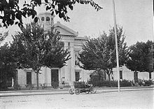
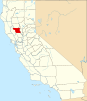
Colusa County is a county located in the U.S. state of California. As of the 2020 census, the population was 21,839. The county seat is Colusa. It is in the northern Sacramento Valley, northwest of the state capital, Sacramento.
West Point is a census-designated place (CDP) in Calaveras County, California, in the United States. As of the 2010 United States Census, West Point's population was 674, down from 746 as of the 2000 census. The town is registered as California Historical Landmark #268. There is an annual West Point Lumberjack Days festival in the community.
Arbuckle is a census-designated place (CDP) in Colusa County, California, United States. The population was 3,028 at the 2010 census, up from 2,332 at the 2000 census. Arbuckle is situated in the southerly portion of Colusa County, approximately 20 miles (32 km) southwest of the City of Colusa, the county seat. The town is characterized by single-family residences, multiple-family units, some mobile homes, and commercial activities. Land surrounding Arbuckle is agriculture including cultivated annual crops, and both active and unmaintained orchards. Various almond hullers may be found near the area. Regional access is provided by the north–south running Interstate 5, along with Old Highway 99 West running alongside Interstate 5.
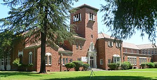
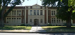
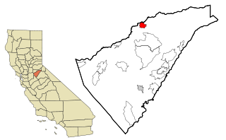
Williams is a city in Colusa County, California. The population was 5,643 at the time of the 2010 census, up from 3,670 at the 2000 census.
Willows is a city and the county seat of Glenn County, California, located in the Sacramento Valley region of Northern California. The city is home to regional government offices, including the California Highway Patrol, the California Department of Motor Vehicles, the United States Bureau of Reclamation and the main offices of the Mendocino National Forest, which comprises about one million acres of Federal land located mostly in mountainous terrain west of Willows. The population was 6,293 at the 2020 census.
Cobb is a census designated place (CDP) in Lake County, California, United States. Cobb is located 1 mile (1.6 km) northwest of Whispering Pines, at an elevation of 2,631 feet (802 m). The population was 1,778 at the 2010 census, up from 1,638 at the 2000 census.
South Whittier is an unincorporated community and census-designated place in Los Angeles County, California just south of the city of Whittier. As of the 2020 census, the CDP had a total population of 56,415, down from 57,156 at the 2010 census.
Le Grand is an unincorporated community and census-designated place (CDP) in Merced County, California, United States. Le Grand is 14 miles (23 km) east-southeast of Merced, the county seat at an elevation of 253 feet (77 m). The population was 1,592 at the 2020 census, down from 1,659 at the 2010 census.
Del Rey Oaks is a city in Monterey County, California, United States. It is located just southeast of Seaside, at an elevation of 82 feet (25 m). The population was 1,592 at the 2020 census. Del Rey Oaks is a member of the Association of Monterey Bay Area Governments, a regional government agency.
American Canyon is a city located in southern Napa County, California, United States, 35 miles (55 km) northeast of San Francisco, part of the San Francisco Bay Area. The 2020 census reported the city's population as 21,837. Its ZIP Code is 94503, and its area code is 707. It is in the Pacific Time time zone and observes Daylight-Saving Time. The city was incorporated in 1992.
North Tustin is an unincorporated community and census designated place (CDP) in Orange County, California. The population was 25,718 at the 2020 census, up from 24,917 in 2010. For statistical purposes, the United States Census Bureau has defined North Tustin as a census-designated place (CDP). It is both the largest CDP and largest unincorporated community in Orange County. The CDP's name was changed from Tustin Foothills in 2005. Located outside the city limits of Tustin, North Tustin has 92705 and 92780 ZIP Codes.
Sunnyside–Tahoe City is a census-designated place (CDP) in Placer County, California, located on the northwest shore of Lake Tahoe. The population was 1,557 at the 2010 census, down from 1,761 at the 2000 census, and a total area of 3.4 sq mi (8.8 km2), all of it land. It comprises two communities, Sunnyside, and Tahoe City.
Empire is a census-designated place (CDP) in Stanislaus County, California, United States. The population was 4,189 at the 2010 census, up from 3,903 at the 2000 census. It is part of the Modesto Metropolitan Statistical Area. Influenced by the Mexican culture, Empire is agriculturally active, and is home to the new Empire Community Park.
New Hampton is a city in, and the county seat of, Chickasaw County, Iowa, United States. The population was 3,494 at the time of the 2020 census.
Bedford is a city in Taylor County, Iowa, United States. The population was 1,508 at the 2020 census. It is the county seat of Taylor County. Lake of Three Fires State Park is located several miles northeast of Bedford.
Bowman is a city in and the county seat of Bowman County, North Dakota, United States. The population was 1,470 at the 2020 census.
Crosby is a city in and the county seat of Divide County, North Dakota, United States. The population was 1,065 at the 2020 census.
Harrington is a city in Lincoln County, Washington, United States. The population was 429 at the 2020 census. It was named after W.P. Harrington, a banker from Colusa, California, who had heavily invested in local land.
New Martinsville is a city in and the county seat of Wetzel County, West Virginia, United States, along the Ohio River. The population was 5,186 at the 2020 census.
Princeton is a census-designated place in Colusa County, California. It lies at an elevation of 82 feet. Its ZIP code is 95970 and its area code is 530. Princeton's population was 303 at the 2010 census.