Red Bluff, California

Last updated

City of Red Bluff
Red Bluff new clocktower.jpg
Cone & Kimball Plaza clocktower, known as the "Center of the City"
Motto: 
"A Great Place To Live"
Tehama County California Incorporated and Unincorporated areas Red Bluff Highlighted.svg
Location in California (left) and Tehama County (right)
Usa edcp relief location map.png
Red pog.svg
City of Red Bluff
Location in the United States
Relief map of California.png
Red pog.svg
City of Red Bluff
City of Red Bluff (California)
Coordinates: 40°10′36″N122°14′17″W / 40.17667°N 122.23806°W / 40.17667; -122.23806
Country United States
State California
County Tehama
Incorporated March 31, 1876 [1]
Area
[2]
   City 7.67 sq mi (19.88 km2)
  Land7.56 sq mi (19.58 km2)
  Water0.11 sq mi (0.30 km2)  1.48%
Elevation
[3]
305 ft (93 m)
Population
 (2020) [4]
   City 14,710
  Density1,900/sq mi (740/km2)
   Urban 18,434
Time zone UTC−8 (Pacific (PST))
  Summer (DST) UTC−7 (PDT)
ZIP code
96080
Area code 530
FIPS code 06-59892
GNIS feature IDs 277581, 2411527
Website Official website OOjs UI icon edit-ltr-progressive.svg

Red Bluff is a city in and the county seat of Tehama County, California, United States. [5] The population was 14,710 at the 2020 census, up from 14,076 at the 2010 census.

Contents

It is located 131 miles (211 kilometers) north of Sacramento, 31 miles (50 km) south of Redding, and it is bisected by Interstate 5. Red Bluff is situated on the banks of the upper Sacramento River. Located in the northernmost part of California’s Central Valley, the city marks the northern end of a vast contiguously cultivated area that extends all the way to Bakersfield, 400 miles (640 km) to the south. Mildly rugged terrain, used as rangeland, separates Red Bluff from the next crop areas to the north in Cottonwood.

It was originally known as Leodocia, but was renamed to Covertsburg in 1853. It got its current name in 1854. [6] Located at the head of navigation on the Sacramento River the town flourished in the mid to late 19th century as a landing point for miners heading to the Trinity County gold fields and later as a temporary terminus for the Southern Pacific Railroad's northward expansion.

Geography

Red Bluff is on the northern edge of the Sacramento Valley, and is the third largest city in the Shasta Cascade region. It is about 31 miles (50 km) south of Redding, 40 miles (64 km) northwest of Chico, and 131 miles (211 km) north of Sacramento.

The city is located at 40°10′36″N122°14′17″W / 40.17667°N 122.23806°W / 40.17667; -122.23806 (40.176640, -122.237951). [7] According to the United States Census Bureau, the city has a total area of 7.7 square miles (20 square kilometers). 7.6 square miles (20 km2) of it is land and 0.1 square miles (0.26 km2) of it is water. The total area is 1.48% water.

History

Odd Fellows Building in downtown Red Bluff (2020) Odd Fellows Building in Red Bluff.jpg
Odd Fellows Building in downtown Red Bluff (2020)
Main Street stores, 1987 Main Street stores, angle view, Red Bluff, California LOC 23537997938.jpg
Main Street stores, 1987

In the early 19th century the Siskiyou Trail was the main north to south path connecting Northern California and Southern Oregon first used by the Native Americans and later fur trappers and hunters. The first European to settle the northern Sacramento Valley in what was then Alta California was Peter Lassen who in 1844 was granted the 24,000 acre Rancho Bosquejo tract from the Mexican government near present-day Vina, about 20 miles southeast of Red Bluff. There he proposed to establish a town but his attempts were thwarted when the California Gold Rush stole the focus of the settlers he had gathered in Missouri. Regardless, the publicity from his colonization efforts attracted new settlers to the valley. In the late 1840s riverboat traffic began expanding northward along the Sacramento River. Lassen's initial attempt to navigate to his ranch in 1849 had failed but the following year a riverboat managed to make the arduous 125-mile journey from Sacramento in 5 months before ultimately being sunk. The discovery of gold near Yreka, California in 1851 brought a new rush northward and settlers soon flooded the area, looking for the quickest route to the gold fields. A site on the Sacramento River just north of Reeds Creek was determined to be the river's navigable head and a small community soon sprung up around the important landing. First known as Leodocia then Covertsburg, by then time a post office was established on October 17, 1853, residents had settled on the name Red Bluff, in recognition of the titular geographical features once prominent along the banks of the Sacramento River. [8] [9] The first postmaster was Samuel Bishop.

Tehama County was created in 1856 and Red Bluff was chosen as the seat of the new county. By 1859 the first permanent courthouse was constructed.

As early as 1854, committees were brought together at Red Bluff to plan a railroad route connecting California to southern Oregon through the Siskyou Mountains via Nobles Pass. The railroad finally reached Red Bluff in 1872 and for a few years it was the terminus, increasing the town's wealth greatly. In the 1880s white supremacists in Red Bluff began an ethnic cleansing campaign against the Chinese residents. In February 1886 thousands of whites in the "Anti-Coolie League" marched on Chinatown and went from house to house, ordering the occupants to leave within ten days. Later that year, after the Chinese population had been expelled, the Chinatown was burned. [10]

Growth slowed by the late 1880s when the railroad was continued north towards Redding but river boat commerce continued well into the 20th century. Mining was largely replaced by agriculture and Red Bluff remained a vital shipping point by rail and eventually highway.

In June 2020, a local Walmart distribution center was the site of a workplace shooting, in which an employee was killed and another four injured. The shooter, identified as a former employee at the distribution center, was then killed by responding police officers. [11]

Climate

Red Bluff has a Mediterranean climate (Köppen: Csa) with cool, wet winters and hot, dry summers. There are an average of 100.1 days annually with highs of 90 °F (32.2 °C) or higher and an average of 21.5 days with lows of 32 °F (0 °C) or lower. The record highest temperature was 121 °F (49.4 °C) on August 7, 1981, and the record lowest temperature was 17 °F (−8.3 °C) on January 9, 1937. Annual precipitation averages 23.21 inches (589.5 mm) with measurable precipitation falling on an average of 71 days. The wettest “rain year” was from July 1994 to June 1995 with 45.96 inches (1,167.4 mm) and the driest from July 1975 to June 1976 with 10.17 inches (258.3 mm). The most rainfall in one month was 21.47 inches (545.3 mm) in January 1995 and the most rainfall in 24 hours was 3.55 inches (90.2 mm) on January 8, 1995. The most snowfall in one month was 15.0 inches (38 cm) in January 1937. On February 24, 2023, Red Bluff received a rare 6 inches (15 cm) of snowfall. [12]

Climate data for Red Bluff, California (Red Bluff Municipal Airport), 1991–2020 normals, extremes 1933present
MonthJanFebMarAprMayJunJulAugSepOctNovDecYear
Record high °F (°C)80
(27)
86
(30)
92
(33)
98
(37)
108
(42)
117
(47)
119
(48)
121
(49)
118
(48)
107
(42)
93
(34)
83
(28)
121
(49)
Mean maximum °F (°C)69.8
(21.0)
74.3
(23.5)
80.7
(27.1)
87.8
(31.0)
97.7
(36.5)
106.9
(41.6)
110.2
(43.4)
107.5
(41.9)
104.7
(40.4)
94.6
(34.8)
79.8
(26.6)
68.4
(20.2)
111.9
(44.4)
Mean daily maximum °F (°C)56.5
(13.6)
60.8
(16.0)
65.7
(18.7)
71.9
(22.2)
81.6
(27.6)
90.8
(32.7)
98.0
(36.7)
96.2
(35.7)
91.4
(33.0)
79.0
(26.1)
64.2
(17.9)
55.7
(13.2)
76.0
(24.4)
Daily mean °F (°C)47.4
(8.6)
50.8
(10.4)
54.7
(12.6)
59.6
(15.3)
68.0
(20.0)
76.4
(24.7)
82.0
(27.8)
79.9
(26.6)
75.4
(24.1)
65.1
(18.4)
53.4
(11.9)
46.8
(8.2)
63.3
(17.4)
Mean daily minimum °F (°C)38.2
(3.4)
40.8
(4.9)
43.7
(6.5)
47.3
(8.5)
54.5
(12.5)
62.0
(16.7)
66.0
(18.9)
63.6
(17.6)
59.3
(15.2)
51.3
(10.7)
42.3
(5.7)
37.8
(3.2)
50.6
(10.3)
Mean minimum °F (°C)28.1
(−2.2)
30.6
(−0.8)
33.4
(0.8)
36.4
(2.4)
43.9
(6.6)
52.1
(11.2)
57.7
(14.3)
56.0
(13.3)
50.3
(10.2)
41.0
(5.0)
31.8
(−0.1)
27.2
(−2.7)
25.0
(−3.9)
Record low °F (°C)17
(−8)
21
(−6)
26
(−3)
28
(−2)
33
(1)
42
(6)
51
(11)
50
(10)
41
(5)
30
(−1)
24
(−4)
13
(−11)
13
(−11)
Average precipitation inches (mm)4.71
(120)
4.15
(105)
2.91
(74)
1.55
(39)
1.25
(32)
0.44
(11)
0.06
(1.5)
0.05
(1.3)
0.19
(4.8)
1.04
(26)
2.54
(65)
4.23
(107)
23.12
(587)
Average precipitation days (≥ 0.01 in)10.39.59.76.65.42.40.30.61.14.07.411.068.3
Source 1: NOAA [13]
Source 2: National Weather Service [14]

Demographics

Historical population
CensusPop.Note
1870 992
1880 2,106112.3%
1890 2,60823.8%
1900 2,7505.4%
1910 3,53028.4%
1920 3,104−12.1%
1930 3,51713.3%
1940 3,8248.7%
1950 4,90528.3%
1960 7,20246.8%
1970 7,6766.6%
1980 9,49023.6%
1990 12,36330.3%
2000 13,1476.3%
2010 14,0767.1%
2020 14,7104.5%
U.S. Decennial Census [15]

2010

At the 2010 census Red Bluff had a population of 14,076. The population density was 1,833.6 inhabitants per square mile (708.0/km2). The racial makeup of Red Bluff was 11,366 (80.7%) White, 128 (0.9%) African American, 438 (3.1%) Native American, 187 (1.3%) Asian, 16 (0.1%) Pacific Islander, 1,168 (8.3%) from other races, and 773 (5.5%) from two or more races. Hispanic or Latino of any race were 3,037 persons (21.6%). [16]

The census reported that 13,637 people (96.9% of the population) lived in households, 150 (1.1%) lived in non-institutionalized group quarters, and 289 (2.1%) were institutionalized.

There were 5,376 households, 2,033 (37.8%) had children under the age of 18 living in them, 1,969 (36.6%) were opposite-sex married couples living together, 1,022 (19.0%) had a female householder with no husband present, 404 (7.5%) had a male householder with no wife present. There were 537 (10.0%) unmarried opposite-sex partnerships, and 27 (0.5%) same-sex married couples or partnerships. 1,629 households (30.3%) were one person and 678 (12.6%) had someone living alone who was 65 or older. The average household size was 2.54. There were 3,395 families (63.2% of households); the average family size was 3.11.

The age distribution was 3,950 people (28.1%) under the age of 18, 1,534 people (10.9%) aged 18 to 24, 3,561 people (25.3%) aged 25 to 44, 3,157 people (22.4%) aged 45 to 64, and 1,874 people (13.3%) who were 65 or older. The median age was 32.2 years. For every 100 females, there were 92.4 males. For every 100 females age 18 and over, there were 87.7 males.

There were 5,872 housing units at an average density of 764.9 per square mile, of the occupied units 2,277 (42.4%) were owner-occupied and 3,099 (57.6%) were rented. The homeowner vacancy rate was 3.5%; the rental vacancy rate was 7.3%. 5,652 people (40.2% of the population) lived in owner-occupied housing units and 7,985 people (56.7%) lived in rental housing units.

2000

At the 2000 census there were 13,147 people in 5,109 households, including 3,239 families, in the city. The population density was 1,768.7 inhabitants per square mile (682.9/km2). There were 5,567 housing units at an average density of 748.9 per square mile (289.2/km2). The racial makeup of the city was 86.7% White, 0.6% Black, 2.2% Native American, 1.6% Asian, 0.1% Pacific Islander, 5.8% from other races, and 3.0% from two or more races. Hispanic or Latino of any race were 13.7%. [17] [18]

Of the 5,109 households 36.2% had children under the age of 18 living with them, 42.4% were married couples living together, 16.5% had a female householder with no husband present, and 36.6% were non-families. 30.7% of households were one person and 14.0% were one person aged 65 or older. The average household size was 2.47 and the average family size was 3.07.

The age distribution was 28.7% under the age of 18, 9.9% from 18 to 24, 28.6% from 25 to 44, 18.0% from 45 to 64, and 14.7% 65 or older. The median age was 34 years. For every 100 females, there were 90.1 males. For every 100 females age 18 and over, there were 84.1 males.

The median income for a household in the city was $27,029, and the median family income was $32,799. Males had a median income of $26,807 versus $21,048 for females. The per capita income for the city was $14,060. About 17.7% of families and 21.1% of the population were below the poverty line, including 29.6% of those under age 18 and 9.7% of those age 65 or over.

Top employers

According to the city's 2022 Annual Comprehensive Financial Report (ACFR), [19] these are the top 10 employers:

#Employer# of Employees
1 County of Tehama 756
2 Saint Elizabeth Community Hospital 610
3 Walmart 340
4 Tehama County Department of Education 285
5 Red Bluff Union Elementary School District 261
6 Red Bluff High School District 213
7City of Red Bluff144
8 The Home Depot 140
9PJ Helicopters180
10 Raley's Supermarkets 85

Events

News

Newspapers

Notable people

Related Research Articles

<span class="mw-page-title-main">Winters, California</span> City in California, United States

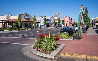
Winters is a city in rural Yolo County, and the western Sacramento Valley, in northern California, United States.

<span class="mw-page-title-main">Glenn County, California</span> County in California, United States

Glenn County is a county located in the U.S. state of California. As of the 2020 census, the population was 28,917. The county seat is Willows. It is located in the Sacramento Valley, in the northern part of the California Central Valley. The Grindstone Rancheria, reservation of the Grindstone Indian Rancheria of Wintun-Wailaki Indians, is located in Glenn County.

<span class="mw-page-title-main">Tehama County, California</span> County in California, United States

Tehama County is a county located in the northern part of the U.S. state of California. As of the 2020 census, the population was 65,829. The county seat and largest city is Red Bluff.

<span class="mw-page-title-main">Colusa, California</span> City in California, United States

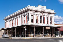
Colusa is a city and county seat of Colusa County, California, located in the Sacramento Valley region of the Central Valley. The population was 5,971 at the 2010 census, up from 5,402 at the 2000 census. Colusi originates from the local Coru Native American tribe, who in the 1840s lived on the opposite side of the Sacramento River.

<span class="mw-page-title-main">Hamilton City, California</span> Census-designated place in California, United States

Hamilton City is a census-designated place (CDP) in Glenn County, California, United States. The population was 1,759 at the 2010 census, down from 1,903 at the 2000 census. Hamilton City is located 9.5 miles (15 km) east of Orland, and 10 miles west of Chico at an elevation of 151 feet. The community is inside area code 530. The default prefix used for wired telephones in the Hamilton City area is 826. The postal ZIP Code is 95951.

<span class="mw-page-title-main">Willows, California</span> City in California, United States

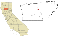
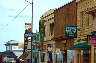
Willows is a city and the county seat of Glenn County, California, located in the Sacramento Valley region of Northern California. The city is home to regional government offices, including the California Highway Patrol, the California Department of Motor Vehicles, the United States Bureau of Reclamation and the main offices of the Mendocino National Forest, which comprises about one million acres of Federal land located mostly in mountainous terrain west of Willows. The population was 6,293 at the 2020 census.

<span class="mw-page-title-main">Susanville, California</span> City in California, United States

Susanville is a city in and is the county seat of Lassen County, California, United States. Susanville is located on the Susan River in the southern part of the county, at an elevation of 4,186 feet (1,276 m). Its population is 16,728 as of the 2020 census, down from 17,947 from the 2010 census. The Susanville urban area contains 8,995 people and 4,233 households.

<span class="mw-page-title-main">Cypress, California</span> City in California, United States

Cypress is a city in northwestern Orange County within Southern California. Its population was 50,151 at the 2020 census.

<span class="mw-page-title-main">Villa Park, California</span> City in California, United States

Villa Park is a city in northern Orange County, California, United States. It was founded in 1962. At the 2010 census, the city had a population of 5,812, making it the smallest city in Orange County.

<span class="mw-page-title-main">Granite Bay, California</span> Census-designated place in California, United States

Granite Bay is a census-designated place (CDP) in Placer County, California, United States. It is part of the Sacramento–Arden-Arcade–Roseville Metropolitan Statistical Area. The population was 21,247 at the 2020 census, up from 20,402 at the 2010 census. The ZIP codes are 95746 and 95661. Granite Bay is a primarily residential suburb of Sacramento and is located just east of Roseville and west of Folsom Lake.

<span class="mw-page-title-main">Lincoln, California</span> City in California, United States

Lincoln is a city in Placer County, California, United States, part of the Sacramento metropolitan area. Located ten miles north of Roseville in an area of rapid suburban development, it grew 282 percent between 2000 and 2010, making it the fastest-growing city over 10,000 people in the U.S. Its 2019 population was estimated to be 48,275.

<span class="mw-page-title-main">Anderson, California</span> City in California, United States

Anderson is a city in Shasta County, California, approximately 10 miles south of Redding. Its population is 11,323 as of the 2020 census, up from 9,932 from the 2010 census.

<span class="mw-page-title-main">Cottonwood, California</span> Census-designated place in the United States

Cottonwood is a census-designated place (CDP) in Shasta County, California, United States. Its population is 6,268 as of the 2020 census, up from 3,316 from the 2010 census. Cottonwood was a stagecoach town where a settlement was established in 1849. The first Post Office was opened in 1852. Cottonwood is equidistant between Redding and Red Bluff, 15 miles (24 km) in either direction. It is 4 miles (6.4 km) south of Anderson.

<span class="mw-page-title-main">Dunsmuir, California</span> City in California, United States

Dunsmuir is a city in Siskiyou County, northern California. It is on the upper Sacramento River. Its population is 1,707 as of the 2020 census, up from 1,650 from the 2010 census.

<span class="mw-page-title-main">Corning, California</span> City in California, United States

Corning is a city in Tehama County, California, that is located about 19 miles (31 km) south of Red Bluff and about 100 miles (160 km) north of Sacramento. The population was 8,244 at the 2020 census, up from 7,663 at the 2010 census.

<span class="mw-page-title-main">Los Molinos, California</span> Census-designated place in California, United States

Los Molinos is a census-designated place (CDP) in Tehama County, California, United States. The population was 2,037 at the 2010 census, up from 1,952 at the 2000 census.

<span class="mw-page-title-main">Tehama, California</span> City in California, United States

Tehama is a city in Tehama County, California, United States. The population was 418 at the 2010 census, down from 432 at the 2000 census.

<span class="mw-page-title-main">Gering, Nebraska</span> City in and county seat of Scotts Bluff County, Nebraska, United States

Gering is a city in and the county seat of Scotts Bluff County, Nebraska, United States, in the Panhandle region of the state. The population was 8,564 at the 2020 census, making it the 17th most populous city in Nebraska.

<span class="mw-page-title-main">Scottsbluff, Nebraska</span> City in Scotts Bluff County, Nebraska, United States

Scottsbluff is a city in Scotts Bluff County, Nebraska, United States, in the Great Plains region. The population was 14,436 at the 2020 census. Scottsbluff is the largest city in the Nebraska Panhandle, and the 13th-most-populous city in Nebraska.

<span class="mw-page-title-main">Bend, California</span> Census-designated place in California, United States

Bend is a census-designated place in Tehama County, California, United States. Bend is located on the Sacramento River 6 miles (9.7 km) north-northeast of Red Bluff. Bend had a post office from 1897 to 1935. The community was originally known as Horsethief Bend; the name was changed to Sander's Bend and later shortened to Bend. The community was named after a nearby meander in the Sacramento River. The population was 619 at the 2010 census.

References

  1. "California Cities by Incorporation Date". California Association of Local Agency Formation Commissions. Archived from the original (Word) on November 3, 2014. Retrieved August 25, 2014.
  2. "2019 U.S. Gazetteer Files". United States Census Bureau. Retrieved July 1, 2020.
  3. "Red Bluff". Geographic Names Information System . United States Geological Survey, United States Department of the Interior . Retrieved November 20, 2014.
  4. "Red Bluff (city) QuickFacts". United States Census Bureau.
  5. "Find a County". National Association of Counties. Archived from the original on May 31, 2011. Retrieved June 7, 2011.
  6. Capace, Nancy (1999). Encyclopedia of California. North American Book Dist LLC. Page 386. ISBN   9780403093182.
  7. "US Gazetteer files: 2010, 2000, and 1990". United States Census Bureau. February 12, 2011. Retrieved April 23, 2011.
  8. "Place Names" (PDF). p. 45. Archived from the original (PDF) on May 8, 2017. Retrieved March 25, 2018.
  9. "Post Offices". Jim Forte Postal History. Retrieved March 26, 2018.
  10. "Red Bluff". Tougaloo College. Retrieved February 12, 2022.
  11. Gross, Jenny; Fazio, Marie (June 27, 2020). "2 Dead in Shooting at Walmart Distribution Center in California, Including Gunman". The New York Times. ISSN   0362-4331 . Retrieved June 28, 2020.
  12. "Tehama County blanketed in snow". February 24, 2023.
  13. "U.S. Climate Normals Quick Access – Station: Red Bluff MUNI AP, CA". National Oceanic and Atmospheric Administration. Retrieved May 23, 2023.
  14. "NOAA Online Weather Data – NWS Sacramento". National Weather Service. Retrieved May 23, 2023.
  15. "Census of Population and Housing". Census.gov. Retrieved June 4, 2015.
  16. "2010 Census Interactive Population Search: CA – Red Bluff city". U.S. Census Bureau. Archived from the original on July 15, 2014. Retrieved July 12, 2014.
  17. "U.S. Census website". United States Census Bureau . Retrieved January 31, 2008.
  18. "96080 Zip Code (Red Bluff, California) Profile – homes, apartments, schools, population, income, averages, housing, demographics, location, statistics, sex offenders, residents and real estate info". www.city-data.com. Archived from the original on January 16, 2017. Retrieved November 19, 2017.
  19. "City Of Red Bluff, California Annual Comprehensive Financial Report For The Fiscal Year Ended June 30, 2022" (PDF). cityofredbluff.org. June 30, 2022. Retrieved September 4, 2023.
  20. Booth, William (April 4, 2005). "Murder, Incorporated?". Washington Post. Archived from the original on November 6, 2011.
  21. Schultz, Jim (November 14, 2017). "Shooter identified as 44-year-old man who had problems with neighbors". Redding Record Searchlight. USA Today. Retrieved November 19, 2017.
  22. "CHL No. 117 Home of Mrs. John Brown – Tehama". California Historic Landmarks . Retrieved February 10, 2022.
  23. Bowles, Samuel (1869) [1865]. Across the Continent : A stage ride over the plains to the Rocky Mountains, the Mormons and the Pacific states, in the summer of 1865, with speaker Colfax. Springfield, Massachusetts. pp. 171–172.{{cite book}}: CS1 maint: location missing publisher (link)